ATL : INVEST 90L
Moderator: S2k Moderators

-
Pedro Fernández

- Tropical Storm

- Posts: 233
- Age: 48
- Joined: Mon Dec 31, 2007 7:24 am
- Location: Costa Tropical (Granada, Spain).
- Contact:
Re: ATL : INVEST 90L=CODE ORANGE
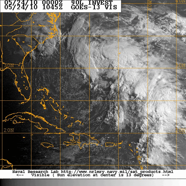
Category 5 wrote:Umm, am I crazy, or do I see multiple spinups on the visible?
Yes... There are some mesovortexes. Another sign of poor organization.
If w-shear doesn't drop.... I don't expect too much from this system.
0 likes
-
HURAKAN

- Professional-Met

- Posts: 46084
- Age: 39
- Joined: Thu May 20, 2004 4:34 pm
- Location: Key West, FL
- Contact:
Re: ATL : INVEST 90L=CODE ORANGE
Jeff Masters:
An extratropical low pressure system (90L) between the Bahamas and Bermuda is moving north-northwest towards North Carolina and is close to tropical storm strength. Last night's ASCAT pass saw a large area of 35 mph winds to the north and east of the center, and buoy 41048 to northeast of 90L's center was seeing sustained ENE winds of 36 mph, gusting to 43 mph this morning. Bermuda is seeing some heavy weather from this storm, with winds blowing at 35 mph on the west end of the island, and the Bermuda radar showing an area of moderate to heavy rain moving over the island. Seas are running 5 - 10 feet in the outer waters of Bermuda today, and are expected to increase to 10 - 14 feet tonight before diminishing on Tuesday.
Strong upper-levels winds out of the west are creating about 25 knots of wind shear over 90L, but the shear has been gradually decreasing over the past day. Visible satellite loops show that 90L does not have a well-defined surface circulation. The main thunderstorm activity is in a large curved band to the north and northeast of the center. This band is several hundred miles removed from the center, which is characteristic of subtropical storms. I expect that 90L will continue to grow more subtropical in nature today through Wednesday as the shear continues to fall. Sea surface temperatures are near 25°C today and will fall to 23 - 24°C on Tuesday. This is warm enough to support a subtropical storm, but probably not a tropical storm. On Wednesday, 90L will be nearing the warm waters of the Gulf Stream, and SSTs will warm again, to the 24 - 25°C range. This is still pretty cool for a tropical storm, and I expect 90L will never become fully tropical. To understand the difference between a tropical and subtropical storm and why we care, see my subtropical storm tutorial.
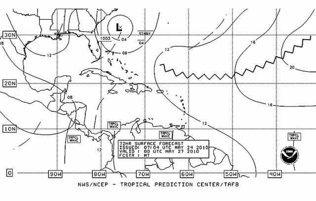
The SHIPS model predicts that shear will fall to the medium 10 - 20 knot range by Tuesday. A large amount of dry air to 90L's southwest associated with the upper-level trough of low pressure on top of the storm, as seen on water vapor satellite loops , will hamper transition of 90L to a subtropical or tropical storm. The system will move slowly towards the Southeast U.S. coast over the next two days, making its closest approach to the coast on Wednesday, when most of the models indicate the center will be 200 - 400 miles southeast of Cape Hatteras, North Carolina. All of the major models currently predict that 90L will not make landfall, but will move slowly eastward out to sea on Thursday, when a trough of low pressure moving across the Eastern U.S. picks up the storm. There presently isn't much to be concerned with about this storm, as it appears that it will remain offshore and will become, at worst, a 40 - 50 mph subtropical storm. The National Hurricane Center (NHC) is giving 90L a medium (30% chance) of developing into a depression or tropical/subtropical storm. Wunderbloggers Weather456 and StormW have more on 90L.
An extratropical low pressure system (90L) between the Bahamas and Bermuda is moving north-northwest towards North Carolina and is close to tropical storm strength. Last night's ASCAT pass saw a large area of 35 mph winds to the north and east of the center, and buoy 41048 to northeast of 90L's center was seeing sustained ENE winds of 36 mph, gusting to 43 mph this morning. Bermuda is seeing some heavy weather from this storm, with winds blowing at 35 mph on the west end of the island, and the Bermuda radar showing an area of moderate to heavy rain moving over the island. Seas are running 5 - 10 feet in the outer waters of Bermuda today, and are expected to increase to 10 - 14 feet tonight before diminishing on Tuesday.
Strong upper-levels winds out of the west are creating about 25 knots of wind shear over 90L, but the shear has been gradually decreasing over the past day. Visible satellite loops show that 90L does not have a well-defined surface circulation. The main thunderstorm activity is in a large curved band to the north and northeast of the center. This band is several hundred miles removed from the center, which is characteristic of subtropical storms. I expect that 90L will continue to grow more subtropical in nature today through Wednesday as the shear continues to fall. Sea surface temperatures are near 25°C today and will fall to 23 - 24°C on Tuesday. This is warm enough to support a subtropical storm, but probably not a tropical storm. On Wednesday, 90L will be nearing the warm waters of the Gulf Stream, and SSTs will warm again, to the 24 - 25°C range. This is still pretty cool for a tropical storm, and I expect 90L will never become fully tropical. To understand the difference between a tropical and subtropical storm and why we care, see my subtropical storm tutorial.
The SHIPS model predicts that shear will fall to the medium 10 - 20 knot range by Tuesday. A large amount of dry air to 90L's southwest associated with the upper-level trough of low pressure on top of the storm, as seen on water vapor satellite loops , will hamper transition of 90L to a subtropical or tropical storm. The system will move slowly towards the Southeast U.S. coast over the next two days, making its closest approach to the coast on Wednesday, when most of the models indicate the center will be 200 - 400 miles southeast of Cape Hatteras, North Carolina. All of the major models currently predict that 90L will not make landfall, but will move slowly eastward out to sea on Thursday, when a trough of low pressure moving across the Eastern U.S. picks up the storm. There presently isn't much to be concerned with about this storm, as it appears that it will remain offshore and will become, at worst, a 40 - 50 mph subtropical storm. The National Hurricane Center (NHC) is giving 90L a medium (30% chance) of developing into a depression or tropical/subtropical storm. Wunderbloggers Weather456 and StormW have more on 90L.
0 likes
-
cwachal
-
HURAKAN
- Professional-Met
- Posts: 46084
- Age: 39
- Joined: Thu May 20, 2004 4:34 pm
- Location: Key West, FL
- Contact:
Re:
cwachal wrote:I know you are a mod but I do have a question isnt that a competitors blog or is that allowed I just want to find out what the rules are
We post here all the information that comes from professional meteorologists as long it's free and open to the public. We appreciate his opinion as much as we appreciate all the comments and analysis that are given by our own members that are professional meteorologists. We don't feel Dr. Masters is a rival in any sense of the word.
0 likes
-
cwachal

-
HURAKAN
- Professional-Met
- Posts: 46084
- Age: 39
- Joined: Thu May 20, 2004 4:34 pm
- Location: Key West, FL
- Contact:
Video Link - http://www.accuweather.com/video.asp
According to the beautiful blonde lady in the video, no Alex this week.
According to the beautiful blonde lady in the video, no Alex this week.
0 likes
-
HURAKAN
- Professional-Met
- Posts: 46084
- Age: 39
- Joined: Thu May 20, 2004 4:34 pm
- Location: Key West, FL
- Contact:
Video Link - http://www.accuweather.com/video/245282 ... -coast.asp
Joe Bastardi talks about 90L and a possible disturbance in the Caribbean
Joe Bastardi talks about 90L and a possible disturbance in the Caribbean
0 likes
-
Category 5

- Category 5

- Posts: 10074
- Age: 36
- Joined: Sun Feb 11, 2007 10:00 pm
- Location: New Brunswick, NJ
- Contact:

I just can't see any development with this system given its a multiple vortex systems and the convection looks like its starting to become more shallow again as well...
0 likes
Personal Forecast Disclaimer:
The posts in this forum are NOT official forecast and should not be used as such. They are just the opinion of the poster and may or may not be backed by sound meteorological data. They are NOT endorsed by any professional institution or storm2k.org. For official information, please refer to the NHC and NWS products
The posts in this forum are NOT official forecast and should not be used as such. They are just the opinion of the poster and may or may not be backed by sound meteorological data. They are NOT endorsed by any professional institution or storm2k.org. For official information, please refer to the NHC and NWS products
-
Category 5
- Category 5
- Posts: 10074
- Age: 36
- Joined: Sun Feb 11, 2007 10:00 pm
- Location: New Brunswick, NJ
- Contact:
Re:
KWT wrote:I just can't see any development with this system given its a multiple vortex systems and the convection looks like its starting to become more shallow again as well...
I agree, that's going to be its ultimate undoing. And it's not like it has alot of time for one of the circulations to take over before it gets shredded.
0 likes
-
HURAKAN
- Professional-Met
- Posts: 46084
- Age: 39
- Joined: Thu May 20, 2004 4:34 pm
- Location: Key West, FL
- Contact:
Re: ATL : INVEST 90L=CODE ORANGE
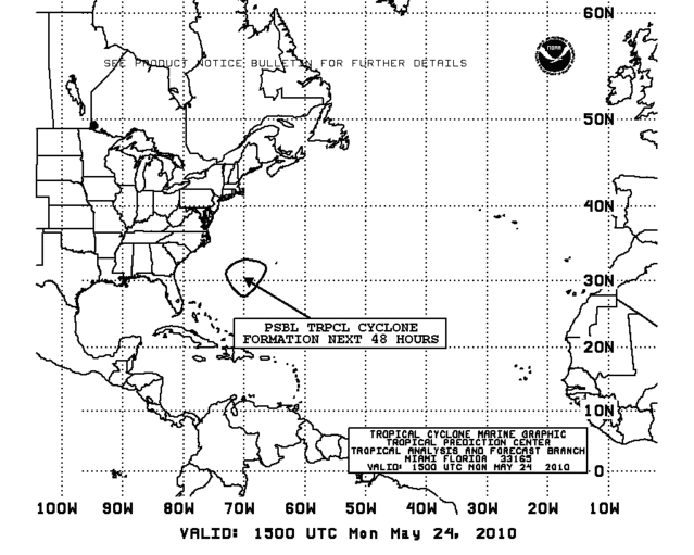
TROPICAL WEATHER DISCUSSION
NWS TPC/NATIONAL HURRICANE CENTER MIAMI FL
205 PM EDT MON MAY 24 2010
...SPECIAL FEATURE...
A DEEP-LAYERED LOW PRESSURE COVERS THE W ATLC NE OF THE BAHAMAS.
TWO 1007 MB CYCLONIC SURFACE CIRCULATIONS ARE CURRENTLY ANALYZED
NEAR 28N70W AND 25N69W. THE SERN CENTER IS FORECAST TO DISSIPATE
AS THE NWRN CENTER SLOWLY PROGRESSES TOWARDS THE NNW. A SURFACE
TROUGH EXTENDS THROUGH BOTH CIRCULATIONS TO TURKS AND CAICOS
ALONG 28N70W 25N68W 20N72W. THE SYSTEM REMAINS DISORGANIZED WITH
THE MAJORITY OF THE CONVECTION WELL REMOVED TO THE NE. SCATTERED
SHOWERS/ISOLATED THUNDERSTORMS ARE N OF 22N BETWEEN 56W-62W.
SIMILAR ACTIVITY IS N OF 28N BETWEEN 62W-74W. ISOLATED SHOWERS
ARE FROM 15N-20N BETWEEN 56W-60W. GALE FORCE WINDS CONTINUE TO
THE NE OF THE SYSTEM. AT THIS TIME THERE IS A MEDIUM CHANCE...30
PERCENT...OF THIS SYSTEM BECOMING A SUBTROPICAL CYCLONE DURING
THE NEXT 48 HOURS.
0 likes
-
pepeavilenho
- Tropical Storm
- Posts: 171
- Joined: Thu Jul 09, 2009 12:01 pm
-
cwachal
-
pepeavilenho
- Tropical Storm
- Posts: 171
- Joined: Thu Jul 09, 2009 12:01 pm
Re: ATL : INVEST 90L=CODE ORANGE
HURAKAN wrote:12z
AL, 90, 2010052418, , BEST, 0, 279N, 704W, 40, 1006, LO
It increases the surface winds, but not the convection....
Maybe we've to wait until Tuesday evening...
0 likes
Yeah looks like the broad circulation is strengthening but the system is unable to develop a single LLC because there is no real convection focused anywhere within the system....
0 likes
Personal Forecast Disclaimer:
The posts in this forum are NOT official forecast and should not be used as such. They are just the opinion of the poster and may or may not be backed by sound meteorological data. They are NOT endorsed by any professional institution or storm2k.org. For official information, please refer to the NHC and NWS products
The posts in this forum are NOT official forecast and should not be used as such. They are just the opinion of the poster and may or may not be backed by sound meteorological data. They are NOT endorsed by any professional institution or storm2k.org. For official information, please refer to the NHC and NWS products
Who is online
Users browsing this forum: No registered users and 40 guests