ATL: EX-Tropical Depression FIVE - Discussion

Moderator: S2k Moderators

Message
Author
User avatar
brunota2003
S2K Supporter
S2K Supporter
Posts: 9476
Age: 34
Joined: Sat Jul 30, 2005 9:56 pm
Location: Stanton, KY...formerly Havelock, NC
Contact:

Re: Re:

#201 Postby brunota2003 » Mon Aug 09, 2010 5:10 pm

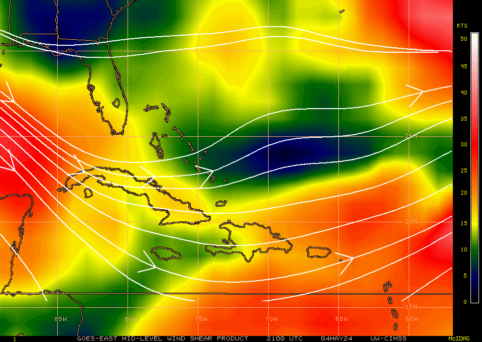
Aric Dunn begin_of_the_skype_highlighting     end_of_the_skype_highlighting wrote:
KWT wrote:I'd personally up the chances to 40% next time round, but I want to see what happens with regards to the old frontal boundary first...


well 30 to 40 not a big deal.. but I jumping on tonight being very beneficial to it as we will lose the boundary interaction over florida that are somewhat inhibiting the eastern semi circle flow..

Plus as it moves away from Florida, more and more of the inflow will be from the ocean itself, versus coming off of land (even if the land is swampy). DMAX should be interesting for this little system.
0 likes   

JonathanBelles
Professional-Met
Professional-Met
Posts: 11430
Age: 35
Joined: Sat Dec 24, 2005 9:00 pm
Location: School: Florida State University (Tallahassee, FL) Home: St. Petersburg, Florida
Contact:

#202 Postby JonathanBelles » Mon Aug 09, 2010 5:11 pm

Looks like I ended up in the dry quadrant today. Only a few storms at my house today. Tomorrow looks like a different story with 60-70% POPs and a slight to moderate chance of waterspouts over the GOM and coastal counties.
0 likes   

Weatherfreak000

Re: Re:

#203 Postby Weatherfreak000 » Mon Aug 09, 2010 5:16 pm

So the longer it's attached the more south the models will go?


It makes little difference. Wxman57 alluded to this earlier. Track guidance remains highly clustered.
Last edited by Weatherfreak000 on Mon Aug 09, 2010 5:16 pm, edited 1 time in total.
0 likes   

User avatar
Ivanhater
Storm2k Moderator
Storm2k Moderator
Posts: 11161
Age: 38
Joined: Fri Jul 01, 2005 8:25 am
Location: Pensacola

Re: ATL: INVEST 94L - Discussion

#204 Postby Ivanhater » Mon Aug 09, 2010 5:16 pm

Image
0 likes   
Michael

Aric Dunn
Category 5
Category 5
Posts: 21238
Age: 42
Joined: Sun Sep 19, 2004 9:58 pm
Location: Ready for the Chase.
Contact:

#205 Postby Aric Dunn » Mon Aug 09, 2010 5:25 pm

if you watch any loop you can see the upper flow shift as it sags south and the upper low heads slowly NW .. this is a sign the upper environment is improving as the SW side of a Upper low is better than the on the west side as it becomes very divergent aloft..
http://www.ssd.noaa.gov/goes/east/gmex/loop-rgb.html
0 likes   
Note: If I make a post that is brief. Please refer back to previous posts for the analysis or reasoning. I do not re-write/qoute what my initial post said each time.
If there is nothing before... then just ask :)

Space & Atmospheric Physicist, Embry-Riddle Aeronautical University,
I believe the sky is falling...

Sanibel
Category 5
Category 5
Posts: 10375
Joined: Mon Aug 30, 2004 11:06 pm
Location: Offshore SW Florida

Re: ATL: INVEST 94L - Discussion

#206 Postby Sanibel » Mon Aug 09, 2010 5:37 pm

The ULL is digging right into it.
0 likes   

lebron23
Category 1
Category 1
Posts: 389
Age: 32
Joined: Sat May 24, 2008 11:58 am
Contact:

Re: ATL: INVEST 94L - Discussion

#207 Postby lebron23 » Mon Aug 09, 2010 5:38 pm

the stronger the system the more west it goes
0 likes   

Frank P
S2K Supporter
S2K Supporter
Posts: 2776
Joined: Fri Aug 29, 2003 10:52 am
Location: Biloxi Beach, Ms
Contact:

Re: ATL: INVEST 94L - Discussion

#208 Postby Frank P » Mon Aug 09, 2010 5:40 pm

Its almost mid August, you would expect something like this to have a little more potential for development, especially since there is so much expectation for developing storms this year.. if it was 2005 we'd have hurricane warnings posted on the MS coast by now.. :)

I just got to believe at some point these systems will began to take off... but it seems like the shear monster has been playing havoc all summer long.. eventually things should take off and the shear monster will settle down.. maybe we're still a couple of weeks away...
0 likes   

User avatar
brunota2003
S2K Supporter
S2K Supporter
Posts: 9476
Age: 34
Joined: Sat Jul 30, 2005 9:56 pm
Location: Stanton, KY...formerly Havelock, NC
Contact:

Re: ATL: INVEST 94L - Discussion

#209 Postby brunota2003 » Mon Aug 09, 2010 5:44 pm

From what I can tell, buoy obs might be hinting at a very, very, very weak llc (I can't plot them like wxman can, so it is difficult to determine with an image). The winds on the eastern side are 6 or 7 knots, though, which is pretty weak.

Of interest will be this observation platform, wnw of Key West (replacement station for the failed Dry Tortugas station).
http://www.ndbc.noaa.gov/station_page.php?station=plsf1

Right now, winds are out of the west at 22 knots, with a pressure of 1011 mb. The winds match (it is south of where Aric was pointing out the low level clouds starting to rotate, so the west wind would be correct), the pressure is still dropping, and the winds are still increasing. It looks like best guess would be 25 knot winds, with a minimum pressure of 1010 millibars at the moment.
0 likes   

Aric Dunn
Category 5
Category 5
Posts: 21238
Age: 42
Joined: Sun Sep 19, 2004 9:58 pm
Location: Ready for the Chase.
Contact:

#210 Postby Aric Dunn » Mon Aug 09, 2010 5:44 pm

Going to be a fun night.. with center reformations and stuff.. lol my favorite time when it all happens on radar :)
0 likes   

User avatar
cycloneye
Admin
Admin
Posts: 145296
Age: 68
Joined: Thu Oct 10, 2002 10:54 am
Location: San Juan, Puerto Rico

Re: ATL: INVEST 94L - Discussion

#211 Postby cycloneye » Mon Aug 09, 2010 5:47 pm

It looks like best guess would be 25 knot winds, with a minimum pressure of 1010 millibars at the moment


Lets see if the 00z Best Track data has those numbers.
0 likes   
Visit the Caribbean-Central America Weather Thread where you can find at first post web cams,radars
and observations from Caribbean basin members Click Here

User avatar
jasons2k
Storm2k Executive
Storm2k Executive
Posts: 8245
Age: 51
Joined: Wed Jul 06, 2005 12:32 pm
Location: The Woodlands, TX

Re: ATL: INVEST 94L - Discussion

#212 Postby jasons2k » Mon Aug 09, 2010 5:49 pm

Looking at Key West radar, it's clear there there are storms at different levels/heights in the atmosphere and they are colliding & moving in different directions all over the place, mostly from west to east and east to west.

In other words, there is still a lot of shear off the SW coast of Florida right now. It's very easy to see on the Key West long range.
0 likes   

User avatar
KWT
Category 5
Category 5
Posts: 31415
Joined: Tue Aug 17, 2004 11:02 am
Location: UK!!!

#213 Postby KWT » Mon Aug 09, 2010 5:52 pm

Well at least we will be able to get a good idea of what is actually happening with this system thanks to good ole radar.

ULL heading NW at a decent clip at the moment, whether that will induce a weakening/strengthening trend will remain to be seen but as the old frontal boundary decays it'll probably be helped by some assistance in terms of upper divergence.
0 likes   
Personal Forecast Disclaimer:
The posts in this forum are NOT official forecast and should not be used as such. They are just the opinion of the poster and may or may not be backed by sound meteorological data. They are NOT endorsed by any professional institution or storm2k.org. For official information, please refer to the NHC and NWS products

User avatar
brunota2003
S2K Supporter
S2K Supporter
Posts: 9476
Age: 34
Joined: Sat Jul 30, 2005 9:56 pm
Location: Stanton, KY...formerly Havelock, NC
Contact:

Re: ATL: INVEST 94L - Discussion

#214 Postby brunota2003 » Mon Aug 09, 2010 5:56 pm

cycloneye wrote:
It looks like best guess would be 25 knot winds, with a minimum pressure of 1010 millibars at the moment


Lets see if the 00z Best Track data has those numbers.

I wouldn't be surprised if it does. That tower has 22 knot winds, with a pressure of 1011, and it isn't even in the heaviest convection...and is still south of the center (with the pressure still dropping).
0 likes   

Ikester
Professional-Met
Professional-Met
Posts: 361
Age: 39
Joined: Mon Jun 21, 2010 5:00 pm
Location: Jacksonville, FL

Re: ATL: INVEST 94L - Discussion

#215 Postby Ikester » Mon Aug 09, 2010 6:00 pm

Any word on recon?
0 likes   

Aric Dunn
Category 5
Category 5
Posts: 21238
Age: 42
Joined: Sun Sep 19, 2004 9:58 pm
Location: Ready for the Chase.
Contact:

#216 Postby Aric Dunn » Mon Aug 09, 2010 6:01 pm

another thing .. this will also be pulled to the convection which is to the south... the NWS local meso forecast the low to be near Key West tomorrow and I would like to agree as it continues to sag south and the center will be pulled/reform closer and under the convection.. so as the ULL Moves NW it should allow the upper environment to improve over night.

shear still dropping pretty quickly..

Image
0 likes   
Note: If I make a post that is brief. Please refer back to previous posts for the analysis or reasoning. I do not re-write/qoute what my initial post said each time.
If there is nothing before... then just ask :)

Space & Atmospheric Physicist, Embry-Riddle Aeronautical University,
I believe the sky is falling...

User avatar
cycloneye
Admin
Admin
Posts: 145296
Age: 68
Joined: Thu Oct 10, 2002 10:54 am
Location: San Juan, Puerto Rico

Re: ATL: INVEST 94L - Discussion

#217 Postby cycloneye » Mon Aug 09, 2010 6:04 pm

Ikester wrote:Any word on recon?


Tomorrow afternoon will be the first mission. There is a thread for recon.

viewtopic.php?f=59&t=108909&p=2032348#p2032348
0 likes   
Visit the Caribbean-Central America Weather Thread where you can find at first post web cams,radars
and observations from Caribbean basin members Click Here

Ikester
Professional-Met
Professional-Met
Posts: 361
Age: 39
Joined: Mon Jun 21, 2010 5:00 pm
Location: Jacksonville, FL

Re: ATL: INVEST 94L - Discussion

#218 Postby Ikester » Mon Aug 09, 2010 6:05 pm

Thanks, I don't know how I missed that. :oops:
0 likes   

User avatar
tailgater
S2K Supporter
S2K Supporter
Posts: 3339
Joined: Sun Jul 11, 2004 9:13 pm
Location: St. Amant La.

Re:

#219 Postby tailgater » Mon Aug 09, 2010 6:12 pm

Aric Dunn wrote:Going to be a fun night.. with center reformations and stuff.. lol my favorite time when it all happens on radar :)

Yeah I heard that!
a couple of inhibiting factors.
Image

WV loop of Dry air to the north and west.
http://www.ssd.noaa.gov/goes/east/gmex/flash-wv.html
0 likes   
The following post is NOT an official forecast and should not be used as such. It is just the opinion of the poster and may or may not be backed by sound meteorological data. It is NOT endorsed by any professional institution including storm2k.org For Official Information please refer to the NHC and NWS products.

User avatar
Comanche
Category 1
Category 1
Posts: 381
Age: 53
Joined: Wed Jul 06, 2005 9:33 am
Location: Clear Lake City Texas

Re: ATL: INVEST 94L - Discussion

#220 Postby Comanche » Mon Aug 09, 2010 6:16 pm

Sanibel wrote:The ULL is digging right into it.


Thank you for saying this, I was thinking maybe I was crazy. All I see is the ULL moving west into it and also wrapping dry air into the area as well. I don't think much of anything will come out of this and I hope this whole season will go down as a year with so much potential yet horrible upper environment. "2010, the year of shear"

http://www.ssd.noaa.gov/goes/east/gmex/flash-wv.html
0 likes   


Return to “2010”

Who is online

Users browsing this forum: Google Adsense [Bot] and 7 guests