ATL: IGOR - Models
Moderator: S2k Moderators

-
lonelymike
- S2K Supporter

- Posts: 634
- Joined: Sat Jul 26, 2008 10:12 am
- Location: walton county fla
Re: ATL: IGOR - Models
No doubt Gator but as KWT has been pointing out this troughy pattern shows no signs of abating. Hard to believe its 9/10 and no major hurricane in the greater atlantic basin 
0 likes
GO SEMINOLES
-
Florida1118
Re: ATL: IGOR - Models
Models still look like a confused mess...Still have to wait a few days and see if a they can start to agree.
0 likes
-
hurricaneCW
- Category 5

- Posts: 1799
- Joined: Wed Mar 03, 2010 6:20 am
- Location: Toms River, NJ
Re: ATL: IGOR - Models
lonelymike wrote:No doubt Gator but as KWT has been pointing out this troughy pattern shows no signs of abating. Hard to believe its 9/10 and no major hurricane in the greater atlantic basin
There are clearly signs that shows stronger western atlantic ridging and less troughiness otherwise there would be no doubt that Igor would recurve well east of the U.S., and even east of Bermuda, probably 55-60W given it's September and Igor is already above 17N, east of 40W.
0 likes
-
SouthFLTropics

- Category 5
- Posts: 4258
- Age: 50
- Joined: Thu Aug 14, 2003 8:04 am
- Location: Port St. Lucie, Florida
Re: ATL: IGOR - Models
hurricaneCW wrote:lonelymike wrote:No doubt Gator but as KWT has been pointing out this troughy pattern shows no signs of abating. Hard to believe its 9/10 and no major hurricane in the greater atlantic basin
There are clearly signs that shows stronger western atlantic ridging and less troughiness otherwise there would be no doubt that Igor would recurve well east of the U.S., and even east of Bermuda, probably 55-60W given it's September and Igor is already above 17N, east of 40W.
With that in mind CW I have been thinking that maybe the seasons are running about 1 to 2 months behind. If the long range models are correct we are heading into more of an August type pattern instead of a late September/early October pattern.
SFT
0 likes
Fourth Generation Florida Native
Personal Storm History: David 79, Andrew 92, Erin 95, Floyd 99, Irene 99, Frances 04, Jeanne 04, Wilma 05, Matthew 16, Irma 17, Ian 22, Nicole 22, Milton 24
Personal Storm History: David 79, Andrew 92, Erin 95, Floyd 99, Irene 99, Frances 04, Jeanne 04, Wilma 05, Matthew 16, Irma 17, Ian 22, Nicole 22, Milton 24
-
hurricaneCW
- Category 5
- Posts: 1799
- Joined: Wed Mar 03, 2010 6:20 am
- Location: Toms River, NJ
Re: ATL: IGOR - Models
It's a matter of timing, the ridging pattern is likely to be temporary if it does transpire. Probably no longer than 7-10 days, which coincidentally, will be the next time the eastern U.S. is likely to experience well above normal temperatures. The trend west in the models is indicative of stronger subtropical ridging/less troughiness to a certain longitude, but it doesn't mean the storm will be able to make it all the way to the U.S. Chances are, it probably has a 10% chance of making it.
0 likes
Re: ATL: IGOR - Models
00z GFS out to 48 hours shows Igor as a hurricane moving west around 17N/45W...still going west
edit: out to 108 hrs, Igor is at 60W below 20N
at 120 hrs, Igor lifting north now at 20N past 60W
AT 168 hrs, recurving around 62W...and at 174, there she goes north..at 240 passing very close to Nova Scotia and Newfoundland
edit: out to 108 hrs, Igor is at 60W below 20N
at 120 hrs, Igor lifting north now at 20N past 60W
AT 168 hrs, recurving around 62W...and at 174, there she goes north..at 240 passing very close to Nova Scotia and Newfoundland
Last edited by caneseddy on Fri Sep 10, 2010 11:35 pm, edited 4 times in total.
0 likes

-
Wx_Warrior
- Category 5
- Posts: 2718
- Joined: Thu Aug 03, 2006 3:58 pm
- Location: Beaumont, TX
-
cycloneye

- Admin

- Posts: 149475
- Age: 69
- Joined: Thu Oct 10, 2002 10:54 am
- Location: San Juan, Puerto Rico
Re: ATL: IGOR - Models
12z Tropical Models Suite

Code: Select all
WHXX01 KWBC 111305
CHGHUR
TROPICAL CYCLONE GUIDANCE MESSAGE
NWS TPC/NATIONAL HURRICANE CENTER MIAMI FL
1305 UTC SAT SEP 11 2010

DISCLAIMER...NUMERICAL MODELS ARE SUBJECT TO LARGE ERRORS.
PLEASE REFER TO NHC OFFICIAL FORECASTS FOR TROPICAL CYCLONE
AND SUBTROPICAL CYCLONE INFORMATION.

ATLANTIC OBJECTIVE AIDS FOR

TROPICAL CYCLONE IGOR (AL112010) 20100911 1200 UTC

        ...00 HRS...   ...12 HRS...   ...24 HRS. ..   ...36 HRS...
        100911  1200   100912  0000   100912  1200   100913  0000

         LAT    LON     LAT    LON     LAT    LON     LAT    LON
BAMS    17.3N  38.7W   18.0N  41.2W   19.0N  44.1W   20.2N  47.3W
BAMD    17.3N  38.7W   17.7N  41.9W   17.9N  45.0W   18.2N  47.5W
BAMM    17.3N  38.7W   18.0N  41.7W   18.6N  44.8W   19.2N  47.5W
LBAR    17.3N  38.7W   17.9N  41.9W   18.6N  45.1W   19.0N  48.3W
SHIP        60KTS          66KTS          75KTS          83KTS
DSHP        60KTS          66KTS          75KTS          83KTS

        ...48 HRS...   ...72 HRS...   ...96 HRS. ..   ..120 HRS...
        100913  1200   100914  1200   100915  1200   100916  1200

         LAT    LON     LAT    LON     LAT    LON     LAT    LON
BAMS    20.7N  50.9W   19.3N  57.6W   16.6N  59.4W   18.4N  55.7W
BAMD    18.3N  49.5W   19.1N  52.4W   21.1N  54.6W   24.1N  57.8W
BAMM    19.5N  50.1W   19.1N  54.5W   19.2N  55.6W   22.6N  56.2W
LBAR    19.5N  51.1W   20.6N  55.4W   21.6N  57.2W   22.8N  59.5W
SHIP        92KTS         108KTS         114KTS         113KTS
DSHP        92KTS         108KTS         114KTS         113KTS

         ...INITIAL CONDITIONS...
LATCUR =  17.3N LONCUR =  38.7W DIRCUR = 275DEG SPDCUR =  18KT
LATM12 =  17.1N LONM12 =  35.0W DIRM12 = 277DEG SPDM12 =  23KT
LATM24 =  16.3N LONM24 =  30.4W
WNDCUR =   60KT RMAXWD =   25NM WNDM12 =   50KT
CENPRS =  995MB OUTPRS = 1012MB OUTRAD =  240NM SDEPTH =   S
RD34NE =  100NM RD34SE =   60NM RD34SW =   60NM RD34NW = 100NM
0 likes
Visit the Caribbean-Central America Weather Thread where you can find at first post web cams,radars
and observations from Caribbean basin members Click Here
and observations from Caribbean basin members Click Here

Re: ATL: IGOR - Models
The persistent break in subtropical ridge over West Atlantic, with each successive trough moving off the East coast, makes me think Igor will most likely miss the Leeward Islands and the US. All the long range guidance shows this pattern continuing for at least the next 7 to 10 days.
0 likes
-
Typhoon_Willie

- Category 5
- Posts: 1042
- Joined: Mon Jun 09, 2003 3:19 pm
- Location: Greenacres City, Florida
Re: ATL: IGOR - Models
According to those model runs Cycloneye just posted Bermuda may be in the cross hairs.
0 likes
-
hurricaneCW
- Category 5
- Posts: 1799
- Joined: Wed Mar 03, 2010 6:20 am
- Location: Toms River, NJ

Re: ATL: IGOR - Models
hurricaneCW wrote:Hit on Bermuda from the gfs.
yeah that doesnt count as a recurve...
0 likes

Re: ATL: IGOR - Models
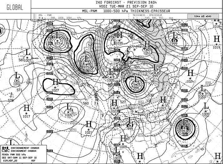
Latest CMC much further west. HWRF also hinting at Igor missing the trough and sneaking under the ridge. Not sure it's an open atlantic recurve yet.
http://moe.met.fsu.edu/cgi-bin/cmctc2.cgi?time=2010091112&field=Sea+Level+Pressure&hour=Animation
http://moe.met.fsu.edu/cgi-bin/hwrftc2.cgi?time=2010091112-invest92l&field=Sea+Level+Pressure&hour=Animation
http://moe.met.fsu.edu/cgi-bin/cmctc2.cgi?time=2010091112&field=Sea+Level+Pressure&hour=Animation
http://moe.met.fsu.edu/cgi-bin/hwrftc2.cgi?time=2010091112-invest92l&field=Sea+Level+Pressure&hour=Animation
0 likes
-
ConvergenceZone
.gif)
- Category 5
- Posts: 5241
- Joined: Fri Jul 29, 2005 1:40 am
- Location: Northern California


Re: ATL: IGOR - Models
12Z UKMET is to the west and slightly to the south of yesterday's 12Z run, at least through 72 hours.
12Z ECMWF still looks fishy (except for Bermuda and perhaps Atlantic Canada, and if you live in those areas that's a might big "except") but looks to be about 200-300 miles west of yesterday's 12Z and today's 00Z ECMWF run.
12Z ECMWF still looks fishy (except for Bermuda and perhaps Atlantic Canada, and if you live in those areas that's a might big "except") but looks to be about 200-300 miles west of yesterday's 12Z and today's 00Z ECMWF run.
Last edited by BigA on Sat Sep 11, 2010 1:51 pm, edited 1 time in total.
0 likes
-
cycloneye
- Admin
- Posts: 149475
- Age: 69
- Joined: Thu Oct 10, 2002 10:54 am
- Location: San Juan, Puerto Rico
Re: ATL: IGOR - Models
18z Tropical Models Suite
Code: Select all
685
WHXX01 KWBC 111844
CHGHUR
TROPICAL CYCLONE GUIDANCE MESSAGE
NWS TPC/NATIONAL HURRICANE CENTER MIAMI FL
1844 UTC SAT SEP 11 2010

DISCLAIMER...NUMERICAL MODELS ARE SUBJECT TO LARGE ERRORS.
PLEASE REFER TO NHC OFFICIAL FORECASTS FOR TROPICAL CYCLONE
AND SUBTROPICAL CYCLONE INFORMATION.

ATLANTIC OBJECTIVE AIDS FOR

TROPICAL CYCLONE IGOR (AL112010) 20100911 1800 UTC

        ...00 HRS...   ...12 HRS...   ...24 HRS. ..   ...36 HRS...
        100911  1800   100912  0600   100912  1800   100913  0600

         LAT    LON     LAT    LON     LAT    LON     LAT    LON
BAMS    17.4N  40.4W   18.2N  42.7W   19.3N  45.5W   20.2N  48.7W
BAMD    17.4N  40.4W   17.6N  43.3W   17.9N  45.8W   18.3N  47.9W
BAMM    17.4N  40.4W   17.8N  43.2W   18.4N  46.0W   18.8N  48.2W
LBAR    17.4N  40.4W   17.9N  43.4W   18.4N  46.6W   18.9N  49.6W
SHIP        60KTS          66KTS          75KTS          85KTS
DSHP        60KTS          66KTS          75KTS          85KTS

        ...48 HRS...   ...72 HRS...   ...96 HRS. ..   ..120 HRS...
        100913  1800   100914  1800   100915  1800   100916  1800

         LAT    LON     LAT    LON     LAT    LON     LAT    LON
BAMS    20.4N  52.0W   18.6N  57.1W   18.2N  56.4W   24.1N  56.1W
BAMD    18.7N  49.6W   20.2N  52.8W   22.5N  56.0W   24.7N  59.6W
BAMM    19.1N  50.5W   19.3N  53.7W   21.2N  55.2W   24.7N  58.5W
LBAR    19.6N  52.4W   21.3N  56.8W   22.4N  59.0W   24.0N  60.2W
SHIP        97KTS         112KTS         123KTS         124KTS
DSHP        97KTS         112KTS         123KTS         124KTS

         ...INITIAL CONDITIONS...
LATCUR =  17.4N LONCUR =  40.4W DIRCUR = 275DEG SPDCUR =  18KT
LATM12 =  17.1N LONM12 =  37.0W DIRM12 = 277DEG SPDM12 =  19KT
LATM24 =  16.6N LONM24 =  32.5W
WNDCUR =   60KT RMAXWD =   25NM WNDM12 =   60KT
CENPRS =  995MB OUTPRS = 1012MB OUTRAD =  240NM SDEPTH =   S
RD34NE =  100NM RD34SE =   60NM RD34SW =   60NM RD34NW = 100NM
0 likes
Visit the Caribbean-Central America Weather Thread where you can find at first post web cams,radars
and observations from Caribbean basin members Click Here
and observations from Caribbean basin members Click Here
Who is online
Users browsing this forum: No registered users and 31 guests