NWS in Mobile places the low 70 miles south of Destin moving west.
http://www.srh.noaa.gov/graphicast.php?site=mob
ATL: EX-Tropical Depression FIVE - Discussion
Moderator: S2k Moderators
-
Dean4Storms
- S2K Supporter

- Posts: 6358
- Age: 63
- Joined: Sun Aug 31, 2003 1:01 pm
- Location: Miramar Bch. FL

Re: ATL: EX-Tropical Depression FIVE - Discussion
MGC wrote:Looks like a sheared naked low to me....but, there is always a chance that some convection could pop near the center thus warenting an upgrade....MGC
Oh I think there is enough present with this one to warrent an upgrade, but upper conditions don't look as good as they were first progged to be as Wxman7 said...now where have we heard that before hmmm....
0 likes
Personal Forecast Disclaimer:
The posts in this forum are NOT official forecast and should not be used as such. They are just the opinion of the poster and may or may not be backed by sound meteorological data. They are NOT endorsed by any professional institution or storm2k.org. For official information, please refer to the NHC and NWS products
The posts in this forum are NOT official forecast and should not be used as such. They are just the opinion of the poster and may or may not be backed by sound meteorological data. They are NOT endorsed by any professional institution or storm2k.org. For official information, please refer to the NHC and NWS products
-
Stormcenter
- S2K Supporter
- Posts: 6689
- Joined: Wed Sep 03, 2003 11:27 am
- Location: Houston, TX
Re: ATL: EX-Tropical Depression FIVE - Discussion
Isn't that what you called it the first time Ex-TD was in the GOM. 
Anyway the convection this time around is much more inpressive especially for
a sheared system. It still has potential (IMO) as long as it remains over
water and the shear lessens somewhat. Neither of course is a done deal.
Anyway the convection this time around is much more inpressive especially for
a sheared system. It still has potential (IMO) as long as it remains over
water and the shear lessens somewhat. Neither of course is a done deal.
MGC wrote:Looks like a sheared naked low to me....but, there is always a chance that some convection could pop near the center thus warenting an upgrade....MGC
0 likes
The only good news is the sheared presentation may allow for slightly less rainfall then was expected as the convection is obviously on the southern side of the system so the rains won't come in until the low is inland.
I still think its going to develop myself...
I still think its going to develop myself...
0 likes
Personal Forecast Disclaimer:
The posts in this forum are NOT official forecast and should not be used as such. They are just the opinion of the poster and may or may not be backed by sound meteorological data. They are NOT endorsed by any professional institution or storm2k.org. For official information, please refer to the NHC and NWS products
The posts in this forum are NOT official forecast and should not be used as such. They are just the opinion of the poster and may or may not be backed by sound meteorological data. They are NOT endorsed by any professional institution or storm2k.org. For official information, please refer to the NHC and NWS products
-
Aric Dunn
- Category 5

- Posts: 21238
- Age: 43
- Joined: Sun Sep 19, 2004 9:58 pm
- Location: Ready for the Chase.
- Contact:
Im sorry although I agree there is a LLC it is still a very sheared system and I guess by definition its a TD with maybe 25kt winds somewhere well removed from the center. But unless there is some sign the shear is going to decrease enough I dont see it making it to TS at this time. the center will never be able to consolidate under the deep convection because of the shear so its going to have a hard time maintaining convergence and thus and convection near the center... maybe if the shear drops say if the upper high shifts back east some then it could reach TS...
http://www.ssd.noaa.gov/goes/flt/t1/loop-rgb.html
http://www.ssd.noaa.gov/goes/flt/t1/loop-rgb.html
0 likes
Note: If I make a post that is brief. Please refer back to previous posts for the analysis or reasoning. I do not re-write/qoute what my initial post said each time.
If there is nothing before... then just ask
Space & Atmospheric Physicist, Embry-Riddle Aeronautical University,
I believe the sky is falling...
If there is nothing before... then just ask
Space & Atmospheric Physicist, Embry-Riddle Aeronautical University,
I believe the sky is falling...
-
MiamiHurricanes10

- S2K Supporter
- Posts: 260
- Joined: Mon Jul 19, 2010 7:56 pm
- Location: Miami, Florida
Re: ATL: EX-Tropical Depression FIVE - Discussion
Elliptical banding features developing. Once these bands get more circular is likely when this thing will ramp up as the circulation tightens. Very likely that Recon will find a tropical depression when they head out at 18:00 UTC (2 PM EDT).

0 likes
-
MiamiHurricanes10
- S2K Supporter
- Posts: 260
- Joined: Mon Jul 19, 2010 7:56 pm
- Location: Miami, Florida
Re: ATL: EX-Tropical Depression FIVE - Discussion
The shear is being overplayed. Yes, 10-20 knots of northeasterly shear are affecting the eastern quadrant of the system. No, not the entire system is experiencing this shear...in fact anticyclonic flow is what most of the system is experiencing, along with 5-10 knots of shear. As it moves SW and then W shear will decrease to favorable conditions. Plus, it may even intensify over the Louisiana marsh land...conditions aloft are favorable there, plus the marsh is very moist and warm.
0 likes
-
Aric Dunn
- Category 5
- Posts: 21238
- Age: 43
- Joined: Sun Sep 19, 2004 9:58 pm
- Location: Ready for the Chase.
- Contact:
Re: ATL: EX-Tropical Depression FIVE - Discussion
MiamiHurricanes10 wrote:The shear is being overplayed. Yes, 10-20 knots of northeasterly shear are affecting the eastern quadrant of the system. No, not the entire system is experiencing this shear...in fact anticyclonic flow is what most of the system is experiencing, along with 5-10 knots of shear. As it moves SW and then W shear will decrease to favorable conditions. Plus, it may even intensify over the Louisiana marsh land...conditions aloft are favorable there, plus the marsh is very moist and warm.
unfortunately the shear is right over the LLC ! it does not matter if the northern half is under low shear and in this case there is no convection there anyway. the shear is not being overplayed its just a statement of current conditions. I dont think anyone said the shear will stay or that it wont strengthen just that right now the shear is holding the system back. So like usual we must wait.. lol

0 likes
Note: If I make a post that is brief. Please refer back to previous posts for the analysis or reasoning. I do not re-write/qoute what my initial post said each time.
If there is nothing before... then just ask
Space & Atmospheric Physicist, Embry-Riddle Aeronautical University,
I believe the sky is falling...
If there is nothing before... then just ask
Space & Atmospheric Physicist, Embry-Riddle Aeronautical University,
I believe the sky is falling...
Yeah I agree MH1, to be honest the NHC could well pull the trigger within the next 6-12hrs IMO, and yeah its sheared but when has that ever stopped the NHC from upgrading in the gulf in the past... 
0 likes
Personal Forecast Disclaimer:
The posts in this forum are NOT official forecast and should not be used as such. They are just the opinion of the poster and may or may not be backed by sound meteorological data. They are NOT endorsed by any professional institution or storm2k.org. For official information, please refer to the NHC and NWS products
The posts in this forum are NOT official forecast and should not be used as such. They are just the opinion of the poster and may or may not be backed by sound meteorological data. They are NOT endorsed by any professional institution or storm2k.org. For official information, please refer to the NHC and NWS products
-
bbadon
- Tropical Storm

- Posts: 190
- Joined: Fri Sep 05, 2003 7:21 am
- Location: Johnson Bayou, LA
- Contact:
Re: ATL: EX-Tropical Depression FIVE - Discussion
It looks to me on long range radar an MLC is developing in the heavier convection. Could this pull the LLC closer to the deeper convection? Also the MLC is south of the LA coast which could provide more time over water. Comments please?
0 likes
-
MiamiHurricanes10
- S2K Supporter
- Posts: 260
- Joined: Mon Jul 19, 2010 7:56 pm
- Location: Miami, Florida
Re: ATL: EX-Tropical Depression FIVE - Discussion
Looks to me like the LLC has advected westward under the convection.

0 likes
-
Aric Dunn
- Category 5
- Posts: 21238
- Age: 43
- Joined: Sun Sep 19, 2004 9:58 pm
- Location: Ready for the Chase.
- Contact:
Re: ATL: EX-Tropical Depression FIVE - Discussion
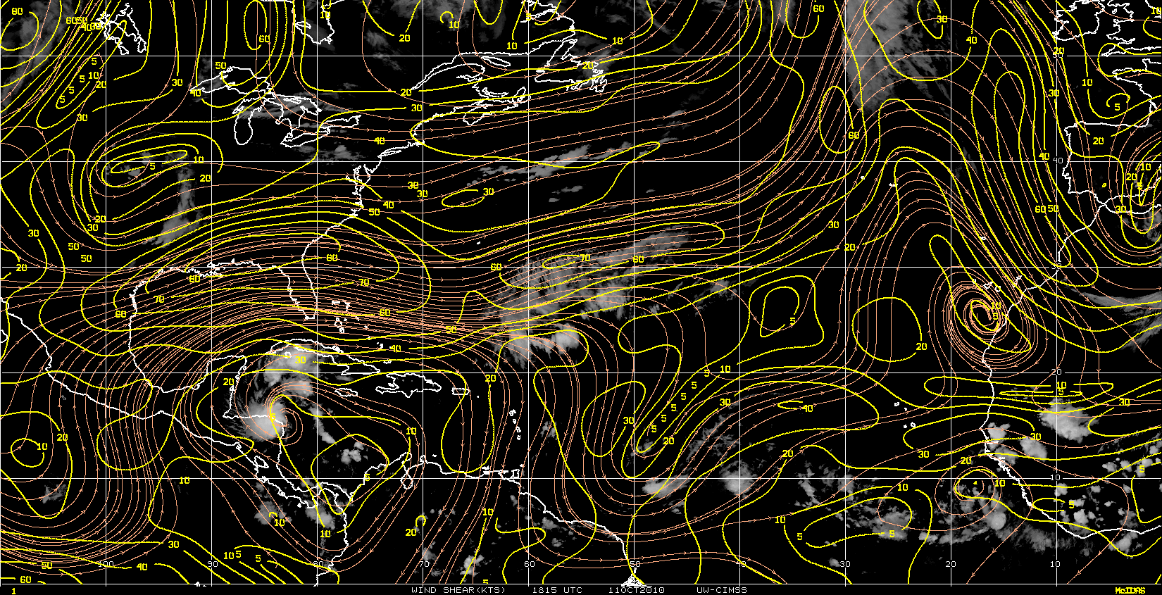
shear is increasing over the LLC as of the 15z cimss which is easily seen on satellite.

0 likes
Note: If I make a post that is brief. Please refer back to previous posts for the analysis or reasoning. I do not re-write/qoute what my initial post said each time.
If there is nothing before... then just ask
Space & Atmospheric Physicist, Embry-Riddle Aeronautical University,
I believe the sky is falling...
If there is nothing before... then just ask
Space & Atmospheric Physicist, Embry-Riddle Aeronautical University,
I believe the sky is falling...
-
MiamiHurricanes10
- S2K Supporter
- Posts: 260
- Joined: Mon Jul 19, 2010 7:56 pm
- Location: Miami, Florida
Re: ATL: EX-Tropical Depression FIVE - Discussion
20 knots is the maximum affecting it as of 15:15 UTC. Anticyclonic flow now above the system...probably why the COC was able to advect westward under the convection.
0 likes
-
vbhoutex

- Storm2k Executive

- Posts: 29149
- Age: 74
- Joined: Wed Oct 09, 2002 11:31 pm
- Location: Cypress, TX
- Contact:
Re: ATL: EX-Tropical Depression FIVE - Discussion
It looks like extd5 is attempting to fill in on the N side of the llc with more and more banding beginning to appear. With the MLC obviously well south under the convection it still has a long way to go to stack and begin any real attempt at "organization". Still appears to be moving W to me with the LLC now almost S of P'cola.IF the LLC were to move SW vs W then I would begin to "worry" that this might make it to TS strength and possibly come further West before the ridge breaks down/splits and takes it inland somewhere over Southern LA.
0 likes
Skywarn, C.E.R.T.
Please click below to donate to STORM2K to help with the expenses of keeping the site going:

Please click below to donate to STORM2K to help with the expenses of keeping the site going:
-
Aric Dunn
- Category 5
- Posts: 21238
- Age: 43
- Joined: Sun Sep 19, 2004 9:58 pm
- Location: Ready for the Chase.
- Contact:
Re: ATL: EX-Tropical Depression FIVE - Discussion
MiamiHurricanes10 wrote:20 knots is the maximum affecting it as of 15:15 UTC. Anticyclonic flow now above the system...probably why the COC was able to advect westward under the convection.
its north of the system and 20kts is a lot of shear.. should still make TD.. but TS is looking less likely..
0 likes
Note: If I make a post that is brief. Please refer back to previous posts for the analysis or reasoning. I do not re-write/qoute what my initial post said each time.
If there is nothing before... then just ask
Space & Atmospheric Physicist, Embry-Riddle Aeronautical University,
I believe the sky is falling...
If there is nothing before... then just ask
Space & Atmospheric Physicist, Embry-Riddle Aeronautical University,
I believe the sky is falling...
-
tolakram
- Admin
- Posts: 20186
- Age: 62
- Joined: Sun Aug 27, 2006 8:23 pm
- Location: Florence, KY (name is Mark)
Re: ATL: EX-Tropical Depression FIVE - Discussion
Loop: http://wwwghcc.msfc.nasa.gov/cgi-bin/ge ... umframes=5
Regardless of the shear maps reality shows a highly sheared system with little or no convection to the north and east.
Regardless of the shear maps reality shows a highly sheared system with little or no convection to the north and east.
0 likes
M a r k
- - - - -
Join us in chat: Storm2K Chatroom Invite. Android and IOS apps also available.
The posts in this forum are NOT official forecasts and should not be used as such. Posts are NOT endorsed by any professional institution or STORM2K.org. For official information and forecasts, please refer to NHC and NWS products.
-
MGC

- S2K Supporter
- Posts: 5940
- Joined: Sun Mar 23, 2003 9:05 pm
- Location: Pass Christian MS, or what is left.
Re: ATL: EX-Tropical Depression FIVE - Discussion
The center on radar looks to be heading west...not sure if the system is vertically stacked due to the shear...the surface circulation might be a bit east of the radar center....sure does not look to be intensifying much....not sure if NHC will upgrade at this time but ya never know. Slim shot it gets upgraded to TS...flip a coin for TD.......MGC
0 likes
-
ColinDelia

- S2K Supporter
- Posts: 918
- Joined: Mon Aug 29, 2005 5:52 am
- Location: The Beach, FL
Re: ATL: EX-Tropical Depression FIVE - Discussion
CIMSS is showing greater divergence now. Looks to me like maybe the upper level high has moved slightly east? (going by the windbarbs presented)
0 likes

-
ColinDelia
- S2K Supporter
- Posts: 918
- Joined: Mon Aug 29, 2005 5:52 am
- Location: The Beach, FL
Re: ATL: EX-Tropical Depression FIVE - Discussion
Divergence 6 hours ago

Divergence 3 hours ago

Divergence (most recent)

Divergence 3 hours ago
Divergence (most recent)
0 likes
Who is online
Users browsing this forum: No registered users and 62 guests