ARABIAN SEA - DEEP DEPRESSION (03A)

Moderator: S2k Moderators

Message
Author
User avatar
HURAKAN
Professional-Met
Professional-Met
Posts: 46086
Age: 38
Joined: Thu May 20, 2004 4:34 pm
Location: Key West, FL
Contact:

#221 Postby HURAKAN » Wed Jun 02, 2010 4:12 pm

Image

WTIO31 PGTW 022100
MSGID/GENADMIN/NAVMARFCSTCEN PEARL HARBOR HI/JTWC//
SUBJ/TROPICAL CYCLONE 03A (PHET) WARNING NR 009//
RMKS/
1. TROPICAL CYCLONE 03A (PHET) WARNING NR 009
01 ACTIVE TROPICAL CYCLONE IN NORTHIO
MAX SUSTAINED WINDS BASED ON ONE-MINUTE AVERAGE
WIND RADII VALID OVER OPEN WATER ONLY
---
WARNING POSITION:
021800Z --- NEAR 18.5N 59.6E
MOVEMENT PAST SIX HOURS - 310 DEGREES AT 05 KTS
POSITION ACCURATE TO WITHIN 040 NM
POSITION BASED ON CENTER LOCATED BY SATELLITE
PRESENT WIND DISTRIBUTION:
MAX SUSTAINED WINDS - 120 KT, GUSTS 145 KT
WIND RADII VALID OVER OPEN WATER ONLY
RADIUS OF 064 KT WINDS - 035 NM NORTHEAST QUADRANT
040 NM SOUTHEAST QUADRANT
035 NM SOUTHWEST QUADRANT
035 NM NORTHWEST QUADRANT
RADIUS OF 050 KT WINDS - 055 NM NORTHEAST QUADRANT
060 NM SOUTHEAST QUADRANT
055 NM SOUTHWEST QUADRANT
045 NM NORTHWEST QUADRANT
RADIUS OF 034 KT WINDS - 095 NM NORTHEAST QUADRANT
115 NM SOUTHEAST QUADRANT
105 NM SOUTHWEST QUADRANT
075 NM NORTHWEST QUADRANT
REPEAT POSIT: 18.5N 59.6E
---
FORECASTS:
12 HRS, VALID AT:
030600Z --- 19.3N 58.8E
MAX SUSTAINED WINDS - 115 KT, GUSTS 140 KT
WIND RADII VALID OVER OPEN WATER ONLY
RADIUS OF 064 KT WINDS - 025 NM NORTHEAST QUADRANT
030 NM SOUTHEAST QUADRANT
025 NM SOUTHWEST QUADRANT
025 NM NORTHWEST QUADRANT
RADIUS OF 050 KT WINDS - 045 NM NORTHEAST QUADRANT
055 NM SOUTHEAST QUADRANT
045 NM SOUTHWEST QUADRANT
035 NM NORTHWEST QUADRANT
RADIUS OF 034 KT WINDS - 095 NM NORTHEAST QUADRANT
115 NM SOUTHEAST QUADRANT
105 NM SOUTHWEST QUADRANT
075 NM NORTHWEST QUADRANT
VECTOR TO 24 HR POSIT: 330 DEG/ 05 KTS
---
24 HRS, VALID AT:
031800Z --- 20.2N 58.2E
MAX SUSTAINED WINDS - 095 KT, GUSTS 115 KT
WIND RADII VALID OVER OPEN WATER ONLY
RADIUS OF 064 KT WINDS - 035 NM NORTHEAST QUADRANT
040 NM SOUTHEAST QUADRANT
035 NM SOUTHWEST QUADRANT
035 NM NORTHWEST QUADRANT
RADIUS OF 050 KT WINDS - 055 NM NORTHEAST QUADRANT
060 NM SOUTHEAST QUADRANT
055 NM SOUTHWEST QUADRANT
045 NM NORTHWEST QUADRANT
RADIUS OF 034 KT WINDS - 090 NM NORTHEAST QUADRANT
110 NM SOUTHEAST QUADRANT
100 NM SOUTHWEST QUADRANT
070 NM NORTHWEST QUADRANT
VECTOR TO 36 HR POSIT: 355 DEG/ 04 KTS
---
36 HRS, VALID AT:
040600Z --- 21.0N 58.1E
MAX SUSTAINED WINDS - 075 KT, GUSTS 090 KT
WIND RADII VALID OVER OPEN WATER ONLY
VECTOR TO 48 HR POSIT: 035 DEG/ 06 KTS
---
EXTENDED OUTLOOK:
48 HRS, VALID AT:
041800Z --- 22.0N 58.8E
MAX SUSTAINED WINDS - 055 KT, GUSTS 070 KT
WIND RADII VALID OVER OPEN WATER ONLY
VECTOR TO 72 HR POSIT: 055 DEG/ 10 KTS
---
72 HRS, VALID AT:
051800Z --- 24.1N 62.3E
MAX SUSTAINED WINDS - 035 KT, GUSTS 045 KT
WIND RADII VALID OVER OPEN WATER ONLY
DISSIPATING AS A SIGNIFICANT TROPICAL CYCLONE OVER WATER
VECTOR TO 96 HR POSIT: 065 DEG/ 13 KTS
---
LONG RANGE OUTLOOK:
NOTE...ERRORS FOR TRACK HAVE AVERAGED NEAR 250 NM
ON DAY 4 AND 350 NM ON DAY 5... AND FOR INTENSITY
NEAR 20 KT EACH DAY.
---
96 HRS, VALID AT:
061800Z --- 26.3N 67.4E
MAX SUSTAINED WINDS - 030 KT, GUSTS 040 KT
WIND RADII VALID OVER OPEN WATER ONLY
DISSIPATING AS A SIGNIFICANT TROPICAL CYCLONE OVER LAND
VECTOR TO 120 HR POSIT: 065 DEG/ 14 KTS
---
120 HRS, VALID AT:
071800Z --- 28.7N 72.9E
MAX SUSTAINED WINDS - 020 KT, GUSTS 030 KT
WIND RADII VALID OVER OPEN WATER ONLY
DISSIPATED AS A SIGNIFICANT TROPICAL CYCLONE OVER LAND
---
REMARKS:
022100Z POSITION NEAR 18.7N 59.4E.
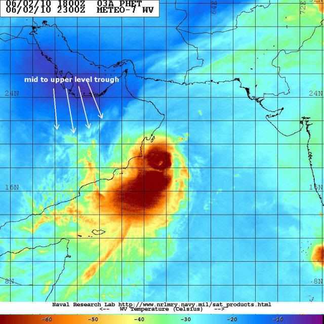
TROPICAL CYCLONE (TC) 03A (PHET), LOCATED APPROXIMATELY 170 NM SOUTH-
SOUTHEAST OF MUSCAT, OMAN, HAS TRACKED NORTHWESTWARD AT 05 KNOTS OVER
THE PAST SIX HOURS. ANIMATED INFRARED SATELLITE IMAGERY SHOWS THE EYE
FEATURE NOTED IN THE PREVIOUS FORECAST HAS BECOME COVERED BY A DENSE
LAYER OF UPPER LEVEL CLOUDS, BUT THE PRESENCE OF A MID LEVEL EYE IS
STILL VISIBLE ON A RECENT 1713Z METOP-A 89 GHZ IMAGE. THE IMAGE ALSO
INDICATES THE DEEPEST CONVECTION REMAINS LOCATED IN THE SOUTHWESTERN
QUADRANT, IN AN AREA OF STRONG GRADIENT CONVERGENCE FROM THE SOUTH-
WEST AND NORTHWEST. A 1711Z ASCAT PASS SHOWED STRONG SOUTHWEST MON-
SOONAL FLOW SUPPORTING A WARM, MOIST AIR MASS MOVING INTO TC 03A. THE
CURRENT INTENSITY IS BASED ON A 6.0/6.5 DVORAK FROM PGTW, WHICH INDI-
CATES A SLIGHT WEAKENING OF TC 03A AS IT BEGINS TO TRACK CLOSER TO
THE COAST OF OMAN. THIS IS SUPPORTED BY THE ANIMATED INFRARED IMAGERY
AS WELL. THE TRACK FOR PHET IS EXPECTED TO REMAIN ON A NORTHWESTWARD
TRACK THROUGH THE NEXT 24 HOURS AS A MID-LEVEL SUBTROPICAL RIDGE
(STR) TO THE EAST OF PHET REMAINS IN PLACE. A TRANSITORY MID-LATITUDE
TROUGH WILL BEGIN TO WEAKEN THE STR ALLOWING TC 03A TO BEGIN TRACKING
NORTHEASTWARD AROUND THE STR. INTENSITY FOR TC 03A IS FORECAST TO
DECREASE THROUGHOUT THE FORECAST PERIOD, AS INCREASING ENTRAINMENT OF
DRY, CONTINENTAL AIR FROM OMAN INTO TC 03A WEAKENS THE SYSTEM. AS
PHET REMAINS OVER OMAN, THE DRY AIR WILL CAUSE A RAPID WEAKENING OF
THE SYSTEM, WITH ONLY A SMALL PERIOD IN WHICH THE LOW LEVEL CIRCULA-
TION CENTER (LLCC) WILL BE BACK OVER WATER. AS THE LLCC QUICKLY
TRACKS INTO INTO THE MID-LATITUDE FLOW, THERE IS LITTLE CHANCE FOR TC
03A TO RE-INTENSIFY. THIS FORECAST IS BASED ON THE CONSENSUS OF
AVAILABLE MODEL AIDS. MAXIMUM SIGNIFICANT WAVE HEIGHT AT 021800Z IS
28 FEET. NEXT WARNINGS AT 030300Z, 030900Z, 031500Z AND 032100Z.//
NNNN
0 likes   

User avatar
P.K.
Professional-Met
Professional-Met
Posts: 5149
Joined: Thu Sep 23, 2004 5:57 pm
Location: Watford, England
Contact:

Re: ARABIAN SEA -VERY SEVERE CYCLONIC STORM PHET (03A)

#222 Postby P.K. » Wed Jun 02, 2010 4:26 pm

This is from the Oman Met Department.

Date: 02/06/2010
Time: 18:00 LST.

The Weather System over Arabian Sea
Warning no. 2

Latest Satellite images and numerical weather prediction charts indicate the tropical cyclone PHET over Arabian Sea has intensified and moved farther towards Omani coasts. Its center at 1800 local located near latitude 18.5 degrees North and longitude 59.5 degrees east. PHET is around 220 km away from Masirah Island with the nearest mass of the convective clouds around 100 km away. Maximum sustained wind speed around the centre are estimated to be around 165 km/h. PHET is expected to continue its movement into a Northwesterly direction towards Sharqiya coast in the next 24 hours with 10 km/h associated with heavy thunder shower accompany with strong winds. Muscat Governate and Aldhakhlia region might be affected by the convective cloud.
People in the affected areas are to take precautions on the low lands from flowing Wadies because of the heavy rain and Fishermen are also advised to be precautious as seas are expected to be rough along the Sultanate's coastal areas especially the coastal areas of the Arabian Sea as wave heights may reach up to 8 metres. Directorate General of Meteorology and Air Navigation (DGMAN) will continue watching the weather situation and give updates accordingly.
Civil Aviation Affairs
Directorate General of Meteorology and Air Navigation (DGMAN)
Department of Forecasting and Observing Practices
0 likes   

User avatar
KWT
Category 5
Category 5
Posts: 31415
Joined: Tue Aug 17, 2004 11:02 am
Location: UK!!!

Re:

#223 Postby KWT » Wed Jun 02, 2010 4:39 pm

CrazyC83 wrote:Certainly peaked at 1200Z - probably around 120 kt - then rapidly weakened. I'd say about 85 kt right now as it has weakened faster than Dvorak constraints allow (the Raw T# of 4.8 translates to about 85 kt though). I believe Gonu was 80 kt when it hit Oman.


Yeah though the JWTC still has it at 120kts, I'm certain winds not even close to that would be translating downwards with that more stable air driving in.
0 likes   
Personal Forecast Disclaimer:
The posts in this forum are NOT official forecast and should not be used as such. They are just the opinion of the poster and may or may not be backed by sound meteorological data. They are NOT endorsed by any professional institution or storm2k.org. For official information, please refer to the NHC and NWS products

ozonepete
Professional-Met
Professional-Met
Posts: 4743
Joined: Mon Sep 07, 2009 3:23 pm
Location: From Ozone Park, NYC / Now in Brooklyn, NY

Re: Re:

#224 Postby ozonepete » Wed Jun 02, 2010 4:50 pm

KWT wrote:
CrazyC83 wrote:Certainly peaked at 1200Z - probably around 120 kt - then rapidly weakened. I'd say about 85 kt right now as it has weakened faster than Dvorak constraints allow (the Raw T# of 4.8 translates to about 85 kt though). I believe Gonu was 80 kt when it hit Oman.


Yeah though the JWTC still has it at 120kts, I'm certain winds not even close to that would be translating downwards with that more stable air driving in.


Yeah, the dry air entrained at mid-levels will cause the thunderstorms near the center to produce strong downdrafts. The downdrafts to the surface will disrupt the RMW (radius of maximum winds) and weaken it. It will be a cat 2 but maybe even only a cat 1 at landfall. And there still is a possibility it will stall out or loop and then go northeast sooner than forecast - you can see the approaching 500mb trough is not far away if you look at the satellite loops.
0 likes   

ocean2011
Tropical Wave
Tropical Wave
Posts: 4
Joined: Fri May 21, 2010 5:31 pm

Re: ARABIAN SEA -VERY SEVERE CYCLONIC STORM PHET (03A)

#225 Postby ocean2011 » Wed Jun 02, 2010 5:04 pm

I think this storm is going to hit Omani costs tomorrow afternoon,
This is also can be followed by the following link
http://weather.kau.edu.sa/content.aspx? ... &cid=39987
and rainfall charts here
http://weather.kau.edu.sa/Pages-%D8%A7% ... D8%B1.aspx

for 850 mb charts
http://weather.kau.edu.sa/Pages-%D8%B7% ... 9-850.aspx

which can show that the forecast for five days that the cyclone will be moving to the east toward Pakistan
0 likes   

ozonepete
Professional-Met
Professional-Met
Posts: 4743
Joined: Mon Sep 07, 2009 3:23 pm
Location: From Ozone Park, NYC / Now in Brooklyn, NY

Re: ARABIAN SEA -VERY SEVERE CYCLONIC STORM PHET (03A)

#226 Postby ozonepete » Wed Jun 02, 2010 5:51 pm

ocean2011 wrote:I think this storm is going to hit Omani costs tomorrow afternoon,
This is also can be followed by the following link
http://weather.kau.edu.sa/content.aspx? ... &cid=39987
and rainfall charts here
http://weather.kau.edu.sa/Pages-%D8%A7% ... D8%B1.aspx

for 850 mb charts
http://weather.kau.edu.sa/Pages-%D8%B7% ... 9-850.aspx

which can show that the forecast for five days that the cyclone will be moving to the east toward Pakistan


Thanks for the links, Ocean2011! They seem to have PHET coming to or near the coast and then moving north-northeastward along it or just inside it. That makes a lot of sense given the difference (nw or ne) between the models
0 likes   

User avatar
HURAKAN
Professional-Met
Professional-Met
Posts: 46086
Age: 38
Joined: Thu May 20, 2004 4:34 pm
Location: Key West, FL
Contact:

#227 Postby HURAKAN » Wed Jun 02, 2010 6:01 pm

Image

Latest
0 likes   

User avatar
Chacor
Category 5
Category 5
Posts: 10229
Joined: Mon Oct 02, 2006 10:43 pm
Location: Singapore

#228 Postby Chacor » Wed Jun 02, 2010 6:19 pm

Good thing this has weakened rapidly. It was looking a lot like Gonu the sequel for a while.
0 likes   

shah8
Category 1
Category 1
Posts: 363
Joined: Wed Aug 30, 2006 4:36 pm

#229 Postby shah8 » Wed Jun 02, 2010 6:22 pm

The rains, man, the rains, not the wind. The path and the rains. Gonu was bad because of *rains* and path.
0 likes   

User avatar
KWT
Category 5
Category 5
Posts: 31415
Joined: Tue Aug 17, 2004 11:02 am
Location: UK!!!

#230 Postby KWT » Wed Jun 02, 2010 6:35 pm

That tail is now bigger then the system itself, what a strange presentation this system has developed with regards to that tail. Either way it isn't that far away from landfall now, going to be a big area that gets heavy rain.
0 likes   
Personal Forecast Disclaimer:
The posts in this forum are NOT official forecast and should not be used as such. They are just the opinion of the poster and may or may not be backed by sound meteorological data. They are NOT endorsed by any professional institution or storm2k.org. For official information, please refer to the NHC and NWS products

User avatar
HURAKAN
Professional-Met
Professional-Met
Posts: 46086
Age: 38
Joined: Thu May 20, 2004 4:34 pm
Location: Key West, FL
Contact:

#231 Postby HURAKAN » Wed Jun 02, 2010 6:37 pm

Image

Latest
0 likes   

ozonepete
Professional-Met
Professional-Met
Posts: 4743
Joined: Mon Sep 07, 2009 3:23 pm
Location: From Ozone Park, NYC / Now in Brooklyn, NY

Re: ARABIAN SEA -VERY SEVERE CYCLONIC STORM PHET (03A)

#232 Postby ozonepete » Wed Jun 02, 2010 7:11 pm

Thanks, Hurakan. A picture is worth a thousand words. This has REALLY bad symmettry now. This and other recent satellite images are showing the trough coming in from the west. Not only is it weakening considerably, but it's becoming more and more likely that it's starting its recurve.

Image
0 likes   

User avatar
KWT
Category 5
Category 5
Posts: 31415
Joined: Tue Aug 17, 2004 11:02 am
Location: UK!!!

#233 Postby KWT » Wed Jun 02, 2010 7:28 pm

The one thing I am noticing on that image there is one hell of an inflow tail there extending to the south of the system. Looks to me like the mid level shear is playing havoc with this system, quite lucky really because it was certainly on its way to category-5 IMO with the structure it had last night.
0 likes   
Personal Forecast Disclaimer:
The posts in this forum are NOT official forecast and should not be used as such. They are just the opinion of the poster and may or may not be backed by sound meteorological data. They are NOT endorsed by any professional institution or storm2k.org. For official information, please refer to the NHC and NWS products

User avatar
HURAKAN
Professional-Met
Professional-Met
Posts: 46086
Age: 38
Joined: Thu May 20, 2004 4:34 pm
Location: Key West, FL
Contact:

#234 Postby HURAKAN » Wed Jun 02, 2010 7:31 pm

Image

eye gone
0 likes   

User avatar
HURAKAN
Professional-Met
Professional-Met
Posts: 46086
Age: 38
Joined: Thu May 20, 2004 4:34 pm
Location: Key West, FL
Contact:

#235 Postby HURAKAN » Wed Jun 02, 2010 8:34 pm

Image

Keeps weakening
0 likes   

CrazyC83
Professional-Met
Professional-Met
Posts: 34001
Joined: Tue Mar 07, 2006 11:57 pm
Location: Deep South, for the first time!

#236 Postby CrazyC83 » Wed Jun 02, 2010 8:42 pm

Without Recon, it is really hard to judge the intensity. I'd have to guess 75 kt right now, but that has quite a bit of uncertainty.
Last edited by CrazyC83 on Wed Jun 02, 2010 8:43 pm, edited 1 time in total.
0 likes   

User avatar
Tom8
Tropical Storm
Tropical Storm
Posts: 195
Joined: Sun Aug 19, 2007 4:36 pm
Location: Poland,Slupsk
Contact:

Re: ARABIAN SEA -VERY SEVERE CYCLONIC STORM PHET (03A)

#237 Postby Tom8 » Wed Jun 02, 2010 8:42 pm

Image

Image
0 likes   

ozonepete
Professional-Met
Professional-Met
Posts: 4743
Joined: Mon Sep 07, 2009 3:23 pm
Location: From Ozone Park, NYC / Now in Brooklyn, NY

Re: ARABIAN SEA -VERY SEVERE CYCLONIC STORM PHET (03A)

#238 Postby ozonepete » Wed Jun 02, 2010 8:45 pm

Elongating fom southwest to northeast. Probably starting the recurve. And still suspicious that it is or has been doing a little counterclockwise loop.
0 likes   

Derek Ortt

#239 Postby Derek Ortt » Wed Jun 02, 2010 9:01 pm

I'll make a quick post, since my first day on the job is not until June 14

http://www.nrlmry.navy.mil/tc-bin/tc_ho ... egreeticks

looks to have underwent an EWRC. The eye, very well defined on microwave, is now quite large. I don't think the weakening was due to dry air, but due to the EWRC
0 likes   

ozonepete
Professional-Met
Professional-Met
Posts: 4743
Joined: Mon Sep 07, 2009 3:23 pm
Location: From Ozone Park, NYC / Now in Brooklyn, NY

Re:

#240 Postby ozonepete » Wed Jun 02, 2010 9:22 pm

Derek Ortt wrote:I'll make a quick post, since my first day on the job is not until June 14

http://www.nrlmry.navy.mil/tc-bin/tc_ho ... egreeticks

looks to have underwent an EWRC. The eye, very well defined on microwave, is now quite large. I don't think the weakening was due to dry air, but due to the EWRC


Hi Derek! Welcome in (prematurely). Since the eyewall on the image you linked to is completely open to the northeast, and other microwave images all day today have shown the same, one has to wonder if the EWRC will ever complete. Do you think it will? And do you think dry air is getting entrained at all yet?
0 likes   


Return to “2010”

Who is online

Users browsing this forum: No registered users and 39 guests