ATL: Ex-Tropical Storm HERMINE - Discussion

Moderator: S2k Moderators

Message
Author
User avatar
HURAKAN
Professional-Met
Professional-Met
Posts: 46086
Age: 38
Joined: Thu May 20, 2004 4:34 pm
Location: Key West, FL
Contact:

Re: ATL: Tropical Storm HERMINE - Discussion

#241 Postby HURAKAN » Mon Sep 06, 2010 8:15 am

Code: Select all

CI# /Pressure/ Vmax
                2.5 /1005.0mb/ 35.0kt

     
             Final T#  Adj T#  Raw T#
                2.5     2.6     3.5


Hermine's look is causing the raw to go haywire!!!
0 likes   

User avatar
HURAKAN
Professional-Met
Professional-Met
Posts: 46086
Age: 38
Joined: Thu May 20, 2004 4:34 pm
Location: Key West, FL
Contact:

#242 Postby HURAKAN » Mon Sep 06, 2010 8:17 am

12z

AL, 10, 2010090612, , BEST, 0, 226N, 954W, 45, 998, TS

45 knots
0 likes   

lonelymike
S2K Supporter
S2K Supporter
Posts: 634
Joined: Sat Jul 26, 2008 10:12 am
Location: walton county fla

Re: ATL: Tropical Storm HERMINE - Discussion

#243 Postby lonelymike » Mon Sep 06, 2010 8:20 am

Are there any oil or gas rigs along Hermaine's path?
0 likes   


GO SEMINOLES

Weatherfreak000

#244 Postby Weatherfreak000 » Mon Sep 06, 2010 8:21 am

It;s amazing to think last night some members were claiming this would fizzle out! :lol:
0 likes   

jinftl
Category 5
Category 5
Posts: 4312
Joined: Tue Aug 31, 2004 4:47 pm
Location: fort lauderdale, fl

Re: ATL: Tropical Storm HERMINE - Discussion

#245 Postby jinftl » Mon Sep 06, 2010 8:23 am

Given that the forecast cone includes a small part of Texas that isn't even in a t.s. watch (let alone a t.s. warning), I would expect a pretty decent jump north at the 11am advisory for watches and warnings...at least to matagorda, maybe even freeport.

Image
0 likes   

User avatar
KWT
Category 5
Category 5
Posts: 31415
Joined: Tue Aug 17, 2004 11:02 am
Location: UK!!!

#246 Postby KWT » Mon Sep 06, 2010 8:23 am

Raw numbers show exactly whats happening with this one, its rapidly strengthening IMO, classic La Nina type system...take a look at Lorenzo from 2007 for a good example...

No reason this can't reach 65-70kts before it comes inland.
0 likes   
Personal Forecast Disclaimer:
The posts in this forum are NOT official forecast and should not be used as such. They are just the opinion of the poster and may or may not be backed by sound meteorological data. They are NOT endorsed by any professional institution or storm2k.org. For official information, please refer to the NHC and NWS products

redfish1
Tropical Storm
Tropical Storm
Posts: 125
Age: 44
Joined: Thu Jun 17, 2010 9:24 pm
Location: Port Arthur, Tx

Re: ATL: Tropical Storm HERMINE - Discussion

#247 Postby redfish1 » Mon Sep 06, 2010 8:27 am

it should be moving NW at this point but it is still moving N what is going on?
0 likes   

hurricaneCW
Category 5
Category 5
Posts: 1794
Joined: Wed Mar 03, 2010 6:20 am
Location: Toms River, NJ

Re:

#248 Postby hurricaneCW » Mon Sep 06, 2010 8:28 am

KWT wrote:Raw numbers show exactly whats happening with this one, its rapidly strengthening IMO, classic La Nina type system...take a look at Lorenzo from 2007 for a good example...

No reason this can't reach 65-70kts before it comes inland.


I agree. It's getting better and better with each frame, very strong and very cold cloud tops around the center. I'll say minimal cane at landfall.
0 likes   

jinftl
Category 5
Category 5
Posts: 4312
Joined: Tue Aug 31, 2004 4:47 pm
Location: fort lauderdale, fl

Re: ATL: Tropical Storm HERMINE - Discussion

#249 Postby jinftl » Mon Sep 06, 2010 8:32 am

There was a swing in heading of 20 deg over the last 6 hours....from just east of due north at 1am to just west of due north at 7am....if that trend continues it will possibly be labeled as heading nnw at 10am cdt.


SUMMARY OF 700 AM CDT...1200 UTC...INFORMATION
----------------------------------------------
PRESENT MOVEMENT...N OR 350 DEGREES AT 10 MPH...17 KM/HR


SUMMARY OF 400 AM CDT...0900 UTC...INFORMATION
----------------------------------------------
PRESENT MOVEMENT...N OR 360 DEGREES AT 8 MPH...13 KM/HR


SUMMARY OF 100 AM CDT...0600 UTC...INFORMATION
----------------------------------------------
PRESENT MOVEMENT...N OR 10 DEGREES AT 7 MPH...11 KM/HR

redfish1 wrote:it should be moving NW at this point but it is still moving N what is going on?
0 likes   

Migle
Tropical Storm
Tropical Storm
Posts: 203
Age: 43
Joined: Fri Aug 27, 2010 5:30 pm
Location: New Orleans

Re: ATL: Tropical Storm HERMINE - Discussion

#250 Postby Migle » Mon Sep 06, 2010 8:34 am

redfish1 wrote:it should be moving NW at this point but it is still moving N what is going on?


It is moving NW right now.

http://www.ssd.noaa.gov/goes/east/watl/loop-avn.html

Put the Tropical Forecast Points on and you can see it going on the NHC track.
0 likes   

User avatar
srainhoutx
S2K Supporter
S2K Supporter
Posts: 6919
Age: 67
Joined: Sun Jan 14, 2007 11:34 am
Location: Haywood County, NC
Contact:

Re: ATL: Tropical Storm HERMINE - Discussion

#251 Postby srainhoutx » Mon Sep 06, 2010 8:34 am

RECON will likely find a very impressive system when they arrive...

Image
0 likes   
Carla/Alicia/Jerry(In The Eye)/Michelle/Charley/Ivan/Dennis/Katrina/Rita/Wilma/Ike/Harvey

Member: National Weather Association
Wx Infinity Forums
http://wxinfinity.com/index.php

Facebook.com/WeatherInfinity
Twitter @WeatherInfinity

User avatar
TexasF6
S2K Supporter
S2K Supporter
Posts: 816
Joined: Mon Aug 09, 2004 9:33 pm
Location: Austin, TX

Re: ATL: Tropical Storm HERMINE - Discussion

#252 Postby TexasF6 » Mon Sep 06, 2010 8:35 am

WOBBLE WATCH THE HERMINE EDITION BEGINS!!!!!!!!!! :double: :flag:
0 likes   

User avatar
KWT
Category 5
Category 5
Posts: 31415
Joined: Tue Aug 17, 2004 11:02 am
Location: UK!!!

#253 Postby KWT » Mon Sep 06, 2010 8:36 am

Probably not going to have a huge amount of time over water but La Nina systems in the BoC have a habit of undergoing RI in the SW.BoC, I can think of at least 4-5 decent hurricanes developing in this region from La Ninas.

Probably 50-55kts already...
Last edited by KWT on Mon Sep 06, 2010 8:37 am, edited 1 time in total.
0 likes   
Personal Forecast Disclaimer:
The posts in this forum are NOT official forecast and should not be used as such. They are just the opinion of the poster and may or may not be backed by sound meteorological data. They are NOT endorsed by any professional institution or storm2k.org. For official information, please refer to the NHC and NWS products

lonelymike
S2K Supporter
S2K Supporter
Posts: 634
Joined: Sat Jul 26, 2008 10:12 am
Location: walton county fla

Re: ATL: Tropical Storm HERMINE - Discussion

#254 Postby lonelymike » Mon Sep 06, 2010 8:36 am

lonelymike wrote:Are there any oil or gas rigs along Hermaine's path?
0 likes   


GO SEMINOLES

Migle
Tropical Storm
Tropical Storm
Posts: 203
Age: 43
Joined: Fri Aug 27, 2010 5:30 pm
Location: New Orleans

Re: ATL: Tropical Storm HERMINE - Discussion

#255 Postby Migle » Mon Sep 06, 2010 8:39 am

TexasF6 wrote:WOBBLE WATCH THE HERMINE EDITION BEGINS!!!!!!!!!! :double: :flag:


It's not wobbling. There's nothing to watch as it is going right on the NHC track. :roll:

It looks real good with some cold cloud tops and deep convection. Even if this does make "landfall" 30 miles south of Brownsville, they are still going to get a lot from this.
0 likes   

jinftl
Category 5
Category 5
Posts: 4312
Joined: Tue Aug 31, 2004 4:47 pm
Location: fort lauderdale, fl

Re: ATL: Tropical Storm HERMINE - Discussion

#256 Postby jinftl » Mon Sep 06, 2010 8:40 am

A few....but hermine should steer clear of the main oil rig areas

Image

lonelymike wrote:
lonelymike wrote:Are there any oil or gas rigs along Hermaine's path?
0 likes   

User avatar
HURAKAN
Professional-Met
Professional-Met
Posts: 46086
Age: 38
Joined: Thu May 20, 2004 4:34 pm
Location: Key West, FL
Contact:

#257 Postby HURAKAN » Mon Sep 06, 2010 8:42 am

Image

RECON on its way
0 likes   

User avatar
Portastorm
Storm2k Moderator
Storm2k Moderator
Posts: 9914
Age: 63
Joined: Fri Jul 11, 2003 9:16 am
Location: Round Rock, TX
Contact:

Re: ATL: Tropical Storm HERMINE - Discussion

#258 Postby Portastorm » Mon Sep 06, 2010 8:43 am

I'll state the obvious -- wow, that is A LOT of moisture headed our way!
0 likes   

User avatar
Starburst
S2K Supporter
S2K Supporter
Posts: 484
Joined: Sun Aug 28, 2005 11:03 pm
Location: Beeville, TX
Contact:

Re: Re:

#259 Postby Starburst » Mon Sep 06, 2010 8:45 am

Cryomaniac wrote:
wxman57 wrote:
Cryomaniac wrote:Slightly irrelevant, but how do you pronounce Hermine? Like Hermione without the 'o' or as "her-mean"?


It's pronounced her-MEEN, as per NHC name pronunciation guide at nhc.noaa.gov.


Thanks.


NHC Page I was looking at has it pronounced tropical storm Hermine (pronounced Er-meen-e)
0 likes   

jinftl
Category 5
Category 5
Posts: 4312
Joined: Tue Aug 31, 2004 4:47 pm
Location: fort lauderdale, fl

Re: ATL: Tropical Storm HERMINE - Discussion

#260 Postby jinftl » Mon Sep 06, 2010 8:45 am

NATIONAL WEATHER SERVICE AUSTIN/SAN ANTONIO TX
417 AM CDT MON SEP 6 2010

....FLASH FLOOD WATCH IN EFFECT FROM LATE TONIGHT THROUGH
WEDNESDAY MORNING...

THE NATIONAL WEATHER SERVICE IN AUSTIN/SAN ANTONIO HAS ISSUED A

* FLASH FLOOD WATCH FOR THE FOLLOWING COUNTIES IN SOUTH CENTRAL
TEXAS...ATASCOSA...BASTROP...BEXAR...CALDWELL...COMAL...
DEWITT...FAYETTE...FRIO...GONZALES...GUADALUPE...HAYS...
KARNES...LAVACA...LEE...MEDINA...TRAVIS...WILLIAMSON AND
WILSON.

* FROM LATE TONIGHT THROUGH WEDNESDAY MORNING

* EXPECT NUMEROUS BANDS OF HEAVY SHOWERS AND THUNDERSTORMS TO
BEGIN MOVING OVER SOUTH CENTRAL TEXAS LATE TONIGHT. HEAVY
RAINFALL RATES OF 1 TO 3 INCHES PER HOUR WILL BE POSSIBLE.
WIDESPREAD RAINS OF 2 TO 5 INCHES ARE EXPECTED...WITH HIGHER
TOTALS OF 5 TO 10 INCHES POSSIBLE BY MIDDAY WEDNESDAY.

* THE CUMULATIVE HEAVY RAINFALL IS EXPECTED TO PRODUCE SIGNIFICANT
RISES IN AREA RIVERS AND STREAMS...WITH THE HIGHEST THREAT FOR
RIVER RISES EXPECTED ON WEDNESDAY.


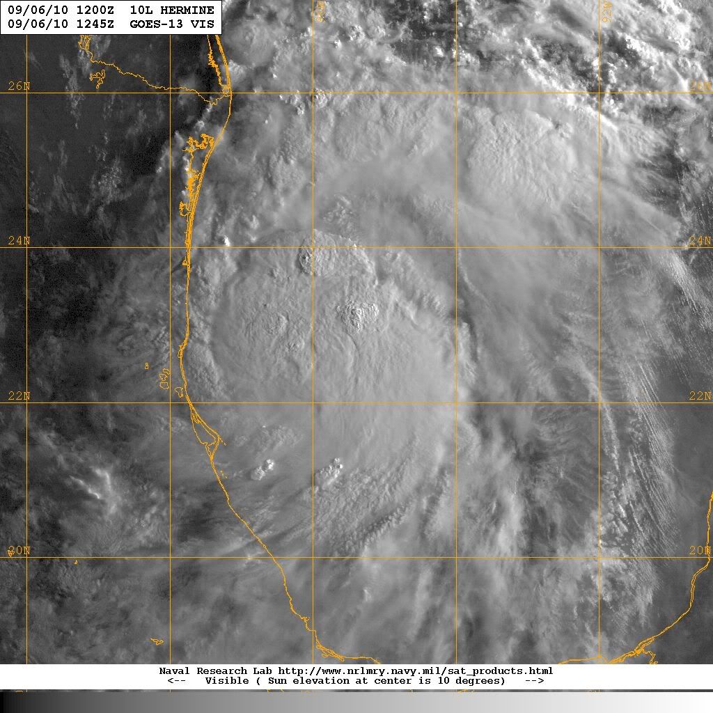
Portastorm wrote:I'll state the obvious -- wow, that is A LOT of moisture headed our way!
0 likes   


Return to “2010”

Who is online

Users browsing this forum: No registered users and 3 guests