ATL: INVEST 95L - DISCUSSION

Moderator: S2k Moderators

Message
Author
User avatar
brunota2003
S2K Supporter
S2K Supporter
Posts: 9476
Age: 34
Joined: Sat Jul 30, 2005 9:56 pm
Location: Stanton, KY...formerly Havelock, NC
Contact:

Re:

#261 Postby brunota2003 » Sun Jul 04, 2010 2:54 pm

Weatherfreak000 wrote:Vorticity maps show that area actually decreased substantially. I'm not certain this is in as good shape as you guys may think.

Look at the size of the system...it is so small, it is a wonder the maps didn't show it shrinking more!
0 likes   

User avatar
KWT
Category 5
Category 5
Posts: 31415
Joined: Tue Aug 17, 2004 11:02 am
Location: UK!!!

#262 Postby KWT » Sun Jul 04, 2010 2:54 pm

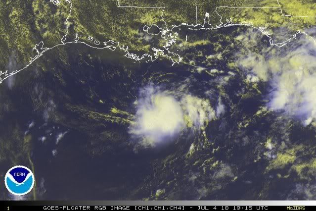
Yep there is a clear circulation and the high resolution Sat.imagery shows this system is wrapping up very quickly and probably is on its way to depression status...

Hard to ignore the wrapping effect going on, probably some very quick development occuring due to its small size...could be TD2 very soon...
0 likes   
Personal Forecast Disclaimer:
The posts in this forum are NOT official forecast and should not be used as such. They are just the opinion of the poster and may or may not be backed by sound meteorological data. They are NOT endorsed by any professional institution or storm2k.org. For official information, please refer to the NHC and NWS products

User avatar
cycloneye
Admin
Admin
Posts: 145294
Age: 68
Joined: Thu Oct 10, 2002 10:54 am
Location: San Juan, Puerto Rico

Re: ATL: INVEST 95L - DISCUSSION

#263 Postby cycloneye » Sun Jul 04, 2010 2:55 pm

LaBreeze wrote:
cycloneye wrote:Rising from the dead.

04/1845 UTC 27.5N 89.8W T1.0/1.0 95L -- Atlantic


What do you mean?


Is the first time that SSD dvorak releases numbers for 95L.

http://www.ssd.noaa.gov/PS/TROP/tdpositions.html
0 likes   
Visit the Caribbean-Central America Weather Thread where you can find at first post web cams,radars
and observations from Caribbean basin members Click Here

User avatar
LaBreeze
Category 5
Category 5
Posts: 1497
Joined: Thu Sep 04, 2003 1:57 pm
Location: SW Louisiana

Re: ATL: INVEST 95L - DISCUSSION

#264 Postby LaBreeze » Sun Jul 04, 2010 2:55 pm

How fast is this little system moving? In which direction? Would it have any time to develop at all?
0 likes   

User avatar
bahamaswx
Category 5
Category 5
Posts: 1542
Joined: Sat Sep 13, 2003 1:11 am
Location: Georgetown, Bahamas

Re: ATL: INVEST 95L - DISCUSSION

#265 Postby bahamaswx » Sun Jul 04, 2010 2:59 pm

LaBreeze wrote:How fast is this little system moving? In which direction? Would it have any time to develop at all?


Just eyeballing the above gif I'd say slightly south of west, perhaps ~12mph. Still waiting for it to turn north.
0 likes   

JonathanBelles
Professional-Met
Professional-Met
Posts: 11430
Age: 35
Joined: Sat Dec 24, 2005 9:00 pm
Location: School: Florida State University (Tallahassee, FL) Home: St. Petersburg, Florida
Contact:

#266 Postby JonathanBelles » Sun Jul 04, 2010 3:00 pm

Meteorologically looks like a Tropical Depression to me. The last ASCAT pass had it as a closed system with light winds. Local obs also seem to point toward a closed low. Satellite is impressive with obvious circulation, good inflow, and building outflow. Shear doesnt seem to be a problem although it is quite high for a cyclogenesis.
0 likes   

User avatar
KWT
Category 5
Category 5
Posts: 31415
Joined: Tue Aug 17, 2004 11:02 am
Location: UK!!!

Re: ATL: INVEST 95L - DISCUSSION

#267 Postby KWT » Sun Jul 04, 2010 3:00 pm

Steve wrote:Looks cool the way it's wrapping up, but there really isn't any support for a depression. I checked most of the buoys, and the highest sustained was around 15k south of Terrebonne Parish. Highest gusts anywhere were around 19k which I think was Shell Beach which isn't actually anywhere near the mass of convection but is near the coastal showers that have been moving across South LA all day today south of New Orleans. MSLP near most of the coastal buoys was running from about 29.94 to 29.96 which was generally between .02 and .05 lower than it was yesterday. Obviously the circulation is there, and it's a miniature low pressure system. In the loop above, you can see what appears to be the low level center starting to pull north(ish).


If this system is as small as it looks, then the winds that may support TD status are probably in a very small zone indeed, Marco's winds were only extending 10 miles from the center so its quite possible that 95L has winds of 20-25kts in that very small system.
0 likes   
Personal Forecast Disclaimer:
The posts in this forum are NOT official forecast and should not be used as such. They are just the opinion of the poster and may or may not be backed by sound meteorological data. They are NOT endorsed by any professional institution or storm2k.org. For official information, please refer to the NHC and NWS products

User avatar
brunota2003
S2K Supporter
S2K Supporter
Posts: 9476
Age: 34
Joined: Sat Jul 30, 2005 9:56 pm
Location: Stanton, KY...formerly Havelock, NC
Contact:

#268 Postby brunota2003 » Sun Jul 04, 2010 3:03 pm

Too bad recon was canceled for today...with it being such a small system, the X pattern wouldn't have to be very big at all. Would definitely be curious what they would find.
0 likes   

User avatar
LaBreeze
Category 5
Category 5
Posts: 1497
Joined: Thu Sep 04, 2003 1:57 pm
Location: SW Louisiana

Re: ATL: INVEST 95L - DISCUSSION

#269 Postby LaBreeze » Sun Jul 04, 2010 3:06 pm

I'm in SW LA and we're having beautiful skies and it almost seems like a northeasterly breeze (slight). Nice break from all of the rain in recent days. :flag:
0 likes   

User avatar
Hurricane Andrew
S2K Supporter
S2K Supporter
Posts: 1891
Age: 26
Joined: Sun May 23, 2010 2:53 pm
Location: KS

#270 Postby Hurricane Andrew » Sun Jul 04, 2010 3:15 pm

Notice this intensified right overe the oil spill!
0 likes   

The Enthusiast
NREMT-AEMT, WX nerd

Irene '11, Sandy '12, Irma '17 (SAR)

"Hard to think we were born to live this way..." -Wage War

ozonepete
Professional-Met
Professional-Met
Posts: 4743
Joined: Mon Sep 07, 2009 3:23 pm
Location: From Ozone Park, NYC / Now in Brooklyn, NY

Re: ATL: INVEST 95L - DISCUSSION

#271 Postby ozonepete » Sun Jul 04, 2010 3:16 pm

Looks like it's developing rapidly now.

Image
0 likes   

Weatherfreak000

Re: ATL: INVEST 95L - DISCUSSION

#272 Postby Weatherfreak000 » Sun Jul 04, 2010 3:18 pm

I would say everything that is ANYTHING in the Atlantic Basin right now is intensifying rapidly.
0 likes   

I-wall
Tropical Storm
Tropical Storm
Posts: 210
Joined: Wed Sep 10, 2008 5:24 pm

Re: ATL: INVEST 95L - DISCUSSION

#273 Postby I-wall » Sun Jul 04, 2010 3:19 pm

Wow, this sure did spin up quickly. Looks like a depression in my amateur opinion.
0 likes   

User avatar
Thunder44
Category 5
Category 5
Posts: 5922
Age: 44
Joined: Mon Jun 09, 2003 7:53 pm
Location: New York City

Re: ATL: INVEST 95L - DISCUSSION

#274 Postby Thunder44 » Sun Jul 04, 2010 3:19 pm

Cold-cloud tops are warming. That's not indication of system that is developing rapdily. I don't think NHC will upgrade this evening:

http://www.ssd.noaa.gov/goes/flt/t1/flash-avn.html
0 likes   

User avatar
wxman57
Moderator-Pro Met
Moderator-Pro Met
Posts: 22978
Age: 67
Joined: Sat Jun 21, 2003 8:06 pm
Location: Houston, TX (southwest)

Re: ATL: INVEST 95L - DISCUSSION

#275 Postby wxman57 » Sun Jul 04, 2010 3:21 pm

Looks kind of like Marco did in the BoC now. I think the surface center may be a bit north of the mid-level center, but they may be aligning. Wouldn't be surprised if the NHC issues a special statement tonight.
0 likes   

User avatar
wxman57
Moderator-Pro Met
Moderator-Pro Met
Posts: 22978
Age: 67
Joined: Sat Jun 21, 2003 8:06 pm
Location: Houston, TX (southwest)

Re:

#276 Postby wxman57 » Sun Jul 04, 2010 3:21 pm

Hurricane Andrew wrote:Notice this intensified right overe the oil spill!


It's west of the oil spill in MC-252.
0 likes   

User avatar
KWT
Category 5
Category 5
Posts: 31415
Joined: Tue Aug 17, 2004 11:02 am
Location: UK!!!

Re: ATL: INVEST 95L - DISCUSSION

#277 Postby KWT » Sun Jul 04, 2010 3:23 pm

Thunder44 wrote:Cold-cloud tops are warming. That's not indication of system that is developing rapdily. I don't think NHC will upgrade this evening:

http://www.ssd.noaa.gov/goes/flt/t1/flash-avn.html


I don't think the IR really matters, its clearly wrapping, its obvious as you can get now really that this is developing into a TD, IMO its pretty clear cut...tops are warming due to D-Min, soon as that eases they will deepen again.
0 likes   
Personal Forecast Disclaimer:
The posts in this forum are NOT official forecast and should not be used as such. They are just the opinion of the poster and may or may not be backed by sound meteorological data. They are NOT endorsed by any professional institution or storm2k.org. For official information, please refer to the NHC and NWS products

ToxicTiger
Tropical Low
Tropical Low
Posts: 11
Age: 66
Joined: Mon Aug 25, 2008 8:37 pm
Location: Baton Rouge, LA

Re: ATL: INVEST 95L - DISCUSSION

#278 Postby ToxicTiger » Sun Jul 04, 2010 3:25 pm

This does not look like a healthy environment for cyclogenisis to me.

Image
0 likes   

I-wall
Tropical Storm
Tropical Storm
Posts: 210
Joined: Wed Sep 10, 2008 5:24 pm

Re: ATL: INVEST 95L - DISCUSSION

#279 Postby I-wall » Sun Jul 04, 2010 3:28 pm

ToxicTiger wrote:This does not look like a healthy environment for cyclogenisis to me.

Image

I dont think so either. But, regardless of that, it looks like something is forming.
0 likes   

User avatar
cycloneye
Admin
Admin
Posts: 145294
Age: 68
Joined: Thu Oct 10, 2002 10:54 am
Location: San Juan, Puerto Rico

Re: ATL: INVEST 95L - DISCUSSION

#280 Postby cycloneye » Sun Jul 04, 2010 3:29 pm

A special Tropical Weather Outlook soon?
0 likes   
Visit the Caribbean-Central America Weather Thread where you can find at first post web cams,radars
and observations from Caribbean basin members Click Here


Return to “2010”

Who is online

Users browsing this forum: No registered users and 3 guests