Wx_Warrior wrote:It was a response to the impression that some are claiming it's moving North.
O.k. - thanks.
Moderator: S2k Moderators
Wx_Warrior wrote:It was a response to the impression that some are claiming it's moving North.

Wx_Warrior wrote:It was a response to the impression that some are claiming it's moving North.
Wx_Warrior wrote:It was a response to the impression that some are claiming it's moving North.
Dean4Storms wrote:Wx_Warrior wrote:It was a response to the impression that some are claiming it's moving North.
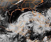
Must of been my post. Yes, watch the sat loop above and high Resolution imagery and over the last 6 hours it has turned more NW, very evident.


ozonepete wrote:Regardless of what happens when it nears Texas later in the week, this has everything going right for it in terms of strengthening for at least the next two days. High SSTs, upper level high right over it, convection blossoming right over the center whiles it's not even far offshore. Looks like a really good candidate for RI, especially once it gets north of the Yucatan.
mpic wrote:From the spaghetti models, it looks like we will have a clear indication by about noon on Tuesday if not before?


drezee wrote:I will try and find some old pics of Opal from 95. This looks a lot like Opal when it started if I recall...had a similar pressure field when it came off the yucatan as well...
drezee wrote:drezee wrote:I will try and find some old pics of Opal from 95. This looks a lot like Opal when it started if I recall...had a similar pressure field when it came off the yucatan as well...
ok, I was dead on...This is a lot like Opal went in at 1003mb and by the time recon got there right on the coast it was 994mb...and yes, that is a 987mb pressure on a 45kt storm...
http://www.nhc.noaa.gov/1995opal.html
01/0000 21.3 89.9 994 45 " "
0600 21.1 90.7 987 45 " "
1200 20.9 91.2 986 45 " "
I am going to go out on a limb here and say once it consolidates...it may do an Opal-type bomb...

Users browsing this forum: No registered users and 131 guests