ATL: Ex Tropical Storm EARL - Discussion
Moderator: S2k Moderators

Re: ATL: Hurricane EARL - Discussion
Curious as to whether the flooding warnings are more storm surge than rainfall.
0 likes
-
jlauderdal
- S2K Supporter

- Posts: 7240
- Joined: Wed May 19, 2004 5:46 am
- Location: NE Fort Lauderdale
- Contact:
Re: ATL: Hurricane EARL - Discussion
dixiebreeze wrote:Anyone recall if Earl even remotely resembles Hugo?
yes, they were both majors
0 likes
-
jlauderdal
- S2K Supporter
- Posts: 7240
- Joined: Wed May 19, 2004 5:46 am
- Location: NE Fort Lauderdale
- Contact:
Re: ATL: Hurricane EARL - Discussion
mpic wrote:Curious as to whether the flooding warnings are more storm surge than rainfall.
there is coastal flooding and the flash flooding, two different things..one comes from the sky the other comes from the ocean, both are a problem if you are in the affected area
0 likes
-
hurricaneCW
- Category 5

- Posts: 1799
- Joined: Wed Mar 03, 2010 6:20 am
- Location: Toms River, NJ
Re: ATL: Hurricane EARL - Discussion
I think of Earl, as of now, like a 2nd rate Hugo. Hugo was one of the biggest east coast monsters that we've ever recorded and not to mention one of the rarest. Earl is much weaker than Hugo and Earl will likely not make landfall on the east coast. I believe the east coast has been spared once again from a direct hit but Earl is as close as you can get with a major east coast landfall.
0 likes
-
thetruesms

- Professional-Met

- Posts: 844
- Age: 42
- Joined: Thu Aug 16, 2007 1:14 pm
- Location: Tallahasee, FL
- Contact:
Re: ATL: Hurricane EARL - Discussion
Somewhat - the GFDL's outermost grid is 75 degrees x 75 degrees, so the influence of the model providing the initial and boundary conditions is mitigated. Otherwise, if the regional model couldn't provide a significant difference from the global paired to it, what's the point of having the regional model at all? However, there is enough of an influence that can cause a noticeable difference.webke wrote:NOGAPS provides the initial conditions for the model, and since the GFDL is a regional model, it also needs a global to supply it boundary conditions, which the GFDN would also get from NOGAPS. So, while the initial data and the general hemispheric flow come from NOGAPS with the same reliability, everything that happens within the model's domain comes from the regional model's physics.
So if I understand you correctly if the data from the NOGAPS is incorrect the output of the GFDN will be also. The interesting thing is that the model run for the NOGAPS was in line with the GFS>
0 likes
-
ozonepete
- Professional-Met
- Posts: 4743
- Joined: Mon Sep 07, 2009 3:23 pm
- Location: From Ozone Park, NYC / Now in Brooklyn, NY
Re: ATL: Hurricane EARL - Discussion
We've got another problem developing here, I think. There could be Fujiwhara effect, where two cyclones that get close enough to each other begin rotating around the midpoint of the line between their centers. This usually starts happening when the centers of the two cyclones are within 800 nm of each other, and the centers of these two are now about 650 nautical miles apart from what I see. When they are roughly equal in intensity they will rotate around each other in a cyclonic fashion. If one is much weaker than the other, the weaker one rotates around the stronger one and often eventually gets absorbed into it, but while that is happening the path of the stronger one can become erratic.
In this case that could mean that Earl may start trying to move west or southwestward, but due to the weakness of Fiona, I wouldn't think it would be be significant. At any rate, it's a wild card that should be watched, because if you watch the latest satellite loops, Fiona is really moving in quite close to Earl now.
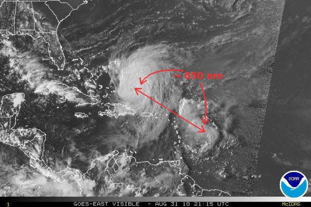
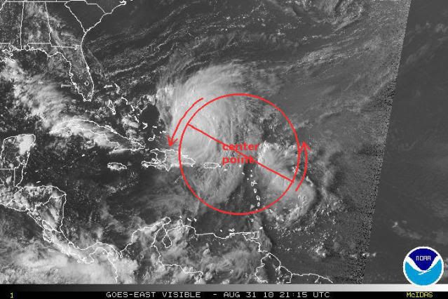
In this case that could mean that Earl may start trying to move west or southwestward, but due to the weakness of Fiona, I wouldn't think it would be be significant. At any rate, it's a wild card that should be watched, because if you watch the latest satellite loops, Fiona is really moving in quite close to Earl now.
0 likes
Re: ATL: Hurricane EARL - Discussion
jlauderdal wrote:mpic wrote:Curious as to whether the flooding warnings are more storm surge than rainfall.
there is coastal flooding and the flash flooding, two different things..one comes from the sky the other comes from the ocean, both are a problem if you are in the affected area
The reason I ask is that won't most of the EC be on the dry side as opposed to the dirty side....how close does Earl have to come to cause widespread flooding due to rain?
0 likes
-
webke

- S2K Supporter
- Posts: 290
- Age: 70
- Joined: Sun Sep 05, 2004 12:39 pm
- Location: North Myrtle Beach SC
Re: ATL: Hurricane EARL - Discussion
thetruesms wrote:Somewhat - the GFDL's outermost grid is 75 degrees x 75 degrees, so the influence of the model providing the initial and boundary conditions is mitigated. Otherwise, if the regional model couldn't provide a significant difference from the global paired to it, what's the point of having the regional model at all? However, there is enough of an influence that can cause a noticeable difference.webke wrote:NOGAPS provides the initial conditions for the model, and since the GFDL is a regional model, it also needs a global to supply it boundary conditions, which the GFDN would also get from NOGAPS. So, while the initial data and the general hemispheric flow come from NOGAPS with the same reliability, everything that happens within the model's domain comes from the regional model's physics.
So if I understand you correctly if the data from the NOGAPS is incorrect the output of the GFDN will be also. The interesting thing is that the model run for the NOGAPS was in line with the GFS>
Thanks for clearing that up.
0 likes
-
ozonepete
- Professional-Met
- Posts: 4743
- Joined: Mon Sep 07, 2009 3:23 pm
- Location: From Ozone Park, NYC / Now in Brooklyn, NY
Re: ATL: Hurricane EARL - Discussion
hurricaneCW wrote:I think of Earl, as of now, like a 2nd rate Hugo. Hugo was one of the biggest east coast monsters that we've ever recorded and not to mention one of the rarest. Earl is much weaker than Hugo and Earl will likely not make landfall on the east coast. I believe the east coast has been spared once again from a direct hit but Earl is as close as you can get with a major east coast landfall.
Earl right now is about the same intensity that Hugo was at landfall at Charleston.
0 likes

Re: ATL: Hurricane EARL - Discussion
i asked about that fujiwhara effect earlier and a pro met told me that it is unlikely because earl is just so much stronger than fiona, I would logically think though that as it got closer, it could suck some strength away from earl and the interaction would weaken both system
0 likes
-
ozonepete
- Professional-Met
- Posts: 4743
- Joined: Mon Sep 07, 2009 3:23 pm
- Location: From Ozone Park, NYC / Now in Brooklyn, NY
Re: ATL: Hurricane EARL - Discussion
mpic wrote:jlauderdal wrote:mpic wrote:Curious as to whether the flooding warnings are more storm surge than rainfall.
there is coastal flooding and the flash flooding, two different things..one comes from the sky the other comes from the ocean, both are a problem if you are in the affected area
The reason I ask is that won't most of the EC be on the dry side as opposed to the dirty side....how close does Earl have to come to cause widespread flooding due to rain?
The heaviest rains are usually on the NORTHWEST side of a hurricane going from the Carolinas northward - that is where the area of maximum vorticity and deformation zones occur. Also there is lift up against the upsloping Appalachians that helps produce more heavy rain. The maximum WINDS are on the east side. ProMets correct me if that's too general a statement.
0 likes
-
webke
- S2K Supporter
- Posts: 290
- Age: 70
- Joined: Sun Sep 05, 2004 12:39 pm
- Location: North Myrtle Beach SC
Re: ATL: Hurricane EARL - Discussion
hurricaneCW wrote:I think of Earl, as of now, like a 2nd rate Hugo. Hugo was one of the biggest east coast monsters that we've ever recorded and not to mention one of the rarest. Earl is much weaker than Hugo and Earl will likely not make landfall on the east coast. I believe the east coast has been spared once again from a direct hit but Earl is as close as you can get with a major east coast landfall.
I was on the north side of Hugo, and it was suppose to make landfall in Myrtle Beach only to change direction at the last minute and head toward Charleston. I would never say at this point that Earl would not likely have a change of heart and direction, anything is possible in the tropics.
Last edited by webke on Tue Aug 31, 2010 5:49 pm, edited 2 times in total.
0 likes
-
ozonepete
- Professional-Met
- Posts: 4743
- Joined: Mon Sep 07, 2009 3:23 pm
- Location: From Ozone Park, NYC / Now in Brooklyn, NY
Re: ATL: Hurricane EARL - Discussion
CronkPSU wrote:i asked about that fujiwhara effect earlier and a pro met told me that it is unlikely because earl is just so much stronger than fiona, I would logically think though that as it got closer, it could suck some strength away from earl and the interaction would weaken both system
Well in past cases, when one was much stronger than the other, the strong one often did not lose strength, but it did show some erratic motion. So the interaction doesn't necessarily weaken both.
0 likes
Re: ATL: Hurricane EARL - Discussion
100 mile difference in 48 hours is well within the standard margin of error
0 likes
Re: ATL: Hurricane EARL - Discussion
Thanks, ozonepete. Trying to make my elderly parents in NC understand that they need to pay attention although they aren't right on the coast.
0 likes
-
hurricaneCW
- Category 5
- Posts: 1799
- Joined: Wed Mar 03, 2010 6:20 am
- Location: Toms River, NJ
Re: ATL: Hurricane EARL - Discussion
I hope Earl follows the track and stays offshore but what will really be interesting is seeing how Earl responds to the environment above 30N. Will he get really massive? What kind of wobbling will we see? How is the trough going to interact with him. Earl should expand once he gets further north. As Danielle went north of 35N, she gained a very large wind field and I bet we'll see the same from Earl.
0 likes
-
SunnyThoughts
- Category 5
- Posts: 2263
- Joined: Wed Jul 09, 2003 12:42 pm
- Location: Pensacola, Florida

-
ozonepete
- Professional-Met
- Posts: 4743
- Joined: Mon Sep 07, 2009 3:23 pm
- Location: From Ozone Park, NYC / Now in Brooklyn, NY
Re: ATL: Hurricane EARL - Discussion
mpic wrote:Thanks, ozonepete. Trying to make my elderly parents in NC understand that they need to pay attention although they aren't right on the coast.
Good Luck to them and you
0 likes
-
ozonepete
- Professional-Met
- Posts: 4743
- Joined: Mon Sep 07, 2009 3:23 pm
- Location: From Ozone Park, NYC / Now in Brooklyn, NY
Re: ATL: Hurricane EARL - Discussion
hurricaneCW wrote:I hope Earl follows the track and stays offshore but what will really be interesting is seeing how Earl responds to the environment above 30N. Will he get really massive? What kind of wobbling will we see? How is the trough going to interact with him. Earl should expand once he gets further north. As Danielle went north of 35N, she gained a very large wind field and I bet we'll see the same from Earl.
It already is well on its way to getting massive. Watch the loops.
Last edited by ozonepete on Tue Aug 31, 2010 5:53 pm, edited 1 time in total.
0 likes
-
Tstormwatcher

- S2K Supporter
- Posts: 3086
- Joined: Thu Oct 20, 2005 7:31 pm
- Location: New Bern, NC
Re: ATL: Hurricane EARL - Discussion
mpic wrote:jlauderdal wrote:mpic wrote:Curious as to whether the flooding warnings are more storm surge than rainfall.
there is coastal flooding and the flash flooding, two different things..one comes from the sky the other comes from the ocean, both are a problem if you are in the affected area
The reason I ask is that won't most of the EC be on the dry side as opposed to the dirty side....how close does Earl have to come to cause widespread flooding due to rain?
I was on the east side of Floyd when it hit NC. We had rain but not very much. Those west of Floyd, from Rocky Mount south to Fayetteville recieved up to 20 inches, had historic flooding. So the west is not always the dry side, but it is usually the less windy side.
0 likes
Who is online
Users browsing this forum: No registered users and 38 guests