ATL: KARL - Ex-Hurricane - Discussion
Moderator: S2k Moderators
-
srainhoutx

- S2K Supporter

- Posts: 6919
- Age: 68
- Joined: Sun Jan 14, 2007 11:34 am
- Location: Haywood County, NC
- Contact:
Re: ATL : INVEST 92L - Discussion
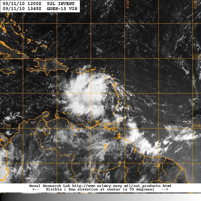
Still lacking deep convection on the eastern half. Another day or so will likely be needed to ramp this up IMO.
0 likes
Carla/Alicia/Jerry(In The Eye)/Michelle/Charley/Ivan/Dennis/Katrina/Rita/Wilma/Ike/Harvey
Member: National Weather Association
Wx Infinity Forums
http://wxinfinity.com/index.php
Facebook.com/WeatherInfinity
Twitter @WeatherInfinity
Member: National Weather Association
Wx Infinity Forums
http://wxinfinity.com/index.php
Facebook.com/WeatherInfinity
Twitter @WeatherInfinity

Re: ATL : INVEST 92L - Discussion
Hats off to the NAM...It never waivered and has been on this every single run since tuesday...The "only" model that remained consistant with development...
0 likes
-
Ivanhater

- Storm2k Moderator

- Posts: 11221
- Age: 39
- Joined: Fri Jul 01, 2005 8:25 am
- Location: Pensacola
Re:
Vortex wrote:Im very concerned for folks in DR/Haiti...It appears based on the synoptics that the center will pass over or very near Haiti with torrential rains likely across the island....
Heavy rain looks to be a certainty for Hispaniola.
0 likes
Michael


Re: ATL : INVEST 92L - Discussion
Vortex wrote:Hats off to the NAM...It never waivered and has been on this every single run since tuesday...The "only" model that remained consistant with development...
yeah vortex, the NAM has consistently developed 92L. I agree this disturbance is well on its way to being a TD. A few models, HWRF and NAM, and yesterdays CMC, bring the system north of the greater antilles. There is a considerable weakness off the SE US that is forecast to deepen over the next few days. If 92L ramps up quickly, it may feel this weakness and get tugged north of the GA. It would probably cross over Hispanola to get to the north side. I think that would be disasterous for the island of Hispanola with mudslides and heavy flooding if that occurred. Wish we had recon today to pinpoint that LLC - there is some rotation on the NE side of the convection this morning.

0 likes
Re: ATL : INVEST 92L - Discussion
Interesting that the 06Z HWRF pegs the LLC at 15.5-64.5 for its 8 am position today. That's where I placed the circulation center from SAT this morning.
http://moe.met.fsu.edu/cgi-bin/hwrftc2.cgi?time=2010091106-invest92l&field=Sea+Level+Pressure&hour=Animation
http://moe.met.fsu.edu/cgi-bin/hwrftc2.cgi?time=2010091106-invest92l&field=Sea+Level+Pressure&hour=Animation
0 likes

Re: ATL : INVEST 92L - Discussion
The HWRF has 92L heading eventually up this way according to the 06 run.
0 likes
12Z Nam still rolling out but like the 6z run it begins a more poleward turn beyond H+54....Given its presentation currently and the fact were likely to have a deeper system in about 2 days this solution can not be ignored...
http://www.nco.ncep.noaa.gov/pmb/nwprod ... loop.shtml
http://www.nco.ncep.noaa.gov/pmb/nwprod ... loop.shtml
0 likes


-
srainhoutx
- S2K Supporter
- Posts: 6919
- Age: 68
- Joined: Sun Jan 14, 2007 11:34 am
- Location: Haywood County, NC
- Contact:
Re: ATL : INVEST 92L - Discussion
Nice anticyclonic flow becoming established. Certainly looking better structurally aloft than it has.
0 likes
Carla/Alicia/Jerry(In The Eye)/Michelle/Charley/Ivan/Dennis/Katrina/Rita/Wilma/Ike/Harvey
Member: National Weather Association
Wx Infinity Forums
http://wxinfinity.com/index.php
Facebook.com/WeatherInfinity
Twitter @WeatherInfinity
Member: National Weather Association
Wx Infinity Forums
http://wxinfinity.com/index.php
Facebook.com/WeatherInfinity
Twitter @WeatherInfinity

This was yesterday's 6Z GFDL run....Sure looks plausible looking at the current/forecasted synoptics....
http://moe.met.fsu.edu/cgi-bin/gfdltc2. ... =Animation
http://moe.met.fsu.edu/cgi-bin/gfdltc2. ... =Animation
0 likes
-
jlauderdal
- S2K Supporter
- Posts: 7240
- Joined: Wed May 19, 2004 5:46 am
- Location: NE Fort Lauderdale
- Contact:
Re: ATL : INVEST 92L - Discussion
srainhoutx wrote:Still lacking deep convection on the eastern half. Another day or so will likely be needed to ramp this up IMO.
yep, we had sunday/monday as the target a few days ago, needed to get away from the SW carib and sure enough its right on schedule, modeling seems to be heading to the hispanola eastern cuba shredder but we shall see what happens, lots of luv for the nam this morning
0 likes
-
wxman57

- Moderator-Pro Met

- Posts: 23175
- Age: 68
- Joined: Sat Jun 21, 2003 8:06 pm
- Location: Houston, TX (southwest)
Re: ATL : INVEST 92L - Discussion
There's a weakness in the ridge to the north over the next 2-3 days but there's a massive ridge over Texas and the NW Gulf to the west of 92L. Either it turns north very shortly or it's Mexico-bound. Texas looks to be OK with the high overhead. I don't think it's turning north, so my money is on Mexico, maybe south of Tampico.
0 likes
-
gatorcane

- S2K Supporter
- Posts: 23708
- Age: 48
- Joined: Sun Mar 13, 2005 3:54 pm
- Location: Boca Raton, FL
I just don't see it making it north of the Greater Antilles. There is alot of convection at the moment, but that does not mean its deepening. Still looks like the whole blob is moving west. As WxMan notes, the weakness is gone in about 2 or 3 days, that would prevent a turn to the NW in the WCAR towards the GOM.
As for Haiti, I wouldn't claim any kind of disaster is setting up with the rain potential, could easily slide south brushing them with rain, but not enough to be disastrous.
As for Haiti, I wouldn't claim any kind of disaster is setting up with the rain potential, could easily slide south brushing them with rain, but not enough to be disastrous.
Last edited by gatorcane on Sat Sep 11, 2010 9:53 am, edited 4 times in total.
0 likes
If the 12Z NAM is correct this would be an absolute disaster for Hispanolia...
H+ 84
http://www.nco.ncep.noaa.gov/pmb/nwprod ... p_084l.gif
H+ 84
http://www.nco.ncep.noaa.gov/pmb/nwprod ... p_084l.gif
0 likes
-
srainhoutx
- S2K Supporter
- Posts: 6919
- Age: 68
- Joined: Sun Jan 14, 2007 11:34 am
- Location: Haywood County, NC
- Contact:
Re: ATL : INVEST 92L - Discussion
We do have a model thread for 92L. Perhaps we should be posting model output in that Topic. 
0 likes
Carla/Alicia/Jerry(In The Eye)/Michelle/Charley/Ivan/Dennis/Katrina/Rita/Wilma/Ike/Harvey
Member: National Weather Association
Wx Infinity Forums
http://wxinfinity.com/index.php
Facebook.com/WeatherInfinity
Twitter @WeatherInfinity
Member: National Weather Association
Wx Infinity Forums
http://wxinfinity.com/index.php
Facebook.com/WeatherInfinity
Twitter @WeatherInfinity
-
jlauderdal
- S2K Supporter
- Posts: 7240
- Joined: Wed May 19, 2004 5:46 am
- Location: NE Fort Lauderdale
- Contact:
Re:
CrazyC83 wrote:I sure hope this isn't Haiti's doomsday storm!!!
flooding rains are a given in that part of the world so lets not get too dramatic every time a tropical system sets up shop over that area, if it isnt this one it will be the next one, its just a fact of life
0 likes
Who is online
Users browsing this forum: No registered users and 62 guests