GOC: EX-TROPICAL CYCLONE PAUL (22P) - Final Advisory
Moderator: S2k Moderators


-
HURAKAN

- Professional-Met

- Posts: 46084
- Age: 39
- Joined: Thu May 20, 2004 4:34 pm
- Location: Key West, FL
- Contact:

WTPS31 PGTW 282100
MSGID/GENADMIN/NAVMARFCSTCEN PEARL HARBOR HI/JTWC//
SUBJ/TROPICAL CYCLONE 22P (PAUL) WARNING NR 003//
RMKS/
1. TROPICAL CYCLONE 22P (PAUL) WARNING NR 003
01 ACTIVE TROPICAL CYCLONE IN SOUTHPAC
MAX SUSTAINED WINDS BASED ON ONE-MINUTE AVERAGE
WIND RADII VALID OVER OPEN WATER ONLY
---
WARNING POSITION:
281800Z --- NEAR 13.3S 136.6E
MOVEMENT PAST SIX HOURS - 135 DEGREES AT 01 KTS
POSITION ACCURATE TO WITHIN 040 NM
POSITION BASED ON CENTER LOCATED BY SATELLITE
PRESENT WIND DISTRIBUTION:
MAX SUSTAINED WINDS - 040 KT, GUSTS 050 KT
WIND RADII VALID OVER OPEN WATER ONLY
RADIUS OF 034 KT WINDS - 035 NM NORTHEAST QUADRANT
035 NM SOUTHEAST QUADRANT
030 NM SOUTHWEST QUADRANT
025 NM NORTHWEST QUADRANT
REPEAT POSIT: 13.3S 136.6E
---
FORECASTS:
12 HRS, VALID AT:
290600Z --- 13.5S 136.6E
MAX SUSTAINED WINDS - 050 KT, GUSTS 065 KT
WIND RADII VALID OVER OPEN WATER ONLY
RADIUS OF 034 KT WINDS - 035 NM NORTHEAST QUADRANT
045 NM SOUTHEAST QUADRANT
040 NM SOUTHWEST QUADRANT
035 NM NORTHWEST QUADRANT
VECTOR TO 24 HR POSIT: 235 DEG/ 02 KTS
---
24 HRS, VALID AT:
291800Z --- 13.7S 136.3E
MAX SUSTAINED WINDS - 055 KT, GUSTS 070 KT
WIND RADII VALID OVER OPEN WATER ONLY
RADIUS OF 050 KT WINDS - 020 NM NORTHEAST QUADRANT
020 NM SOUTHEAST QUADRANT
020 NM SOUTHWEST QUADRANT
020 NM NORTHWEST QUADRANT
RADIUS OF 034 KT WINDS - 035 NM NORTHEAST QUADRANT
045 NM SOUTHEAST QUADRANT
045 NM SOUTHWEST QUADRANT
035 NM NORTHWEST QUADRANT
VECTOR TO 36 HR POSIT: 245 DEG/ 02 KTS
---
36 HRS, VALID AT:
300600Z --- 13.9S 135.9E
MAX SUSTAINED WINDS - 045 KT, GUSTS 055 KT
WIND RADII VALID OVER OPEN WATER ONLY
VECTOR TO 48 HR POSIT: 250 DEG/ 03 KTS
---
EXTENDED OUTLOOK:
48 HRS, VALID AT:
301800Z --- 14.1S 135.4E
MAX SUSTAINED WINDS - 040 KT, GUSTS 050 KT
WIND RADII VALID OVER OPEN WATER ONLY
DISSIPATING AS A SIGNIFICANT TROPICAL CYCLONE OVER LAND
---
REMARKS:
282100Z POSITION NEAR 13.3S 136.6E.
TROPICAL CYCLONE (TC) 22P (PAUL), LOCATED APPROXIMATELY 340 NM EAST
OF DARWIN, AUSTRALIA, HAS BEEN QUASI-STATIONARY OVER THE PAST SIX
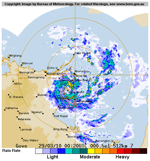
HOURS. ANIMATED INFRARED IMAGERY AND A RADAR LOOP FROM GOVE,
AUSTRALIA SHOW DEEPENING CONVECTIVE BANDING WRAPPING TIGHTLY AROUND
A LOW LEVEL CIRCULATION CENTER (LLCC) WITHIN THE PAST 12 HOURS.
INITIAL INTENSITY IS BASED ON NORTHEAST ISLAND OBSERVATIONS,
APPROXIMATELY 30 NM AWAY FROM THE LLCC, OF 38 KNOTS AND 997 MB.
UPPER LEVEL ANALYSIS INDICATES TC 22P IS LOCATED BENEATH AN AREA OF
DIVERGENCE AND LOW VERTICAL WIND SHEAR, WITH GOOD RADIAL OUTFLOW.
PAUL IS CURRENTLY TRACKING IN A WEAK STEERING ENVIRONMENT BETWEEN A
NEAR EQUATORIAL RIDGE AND A LOW- TO MID-LEVEL SUBTROPICAL RIDGE
(STR) TO THE SOUTH. AS THE STR BUILDS IN AND TAKES STEERING CONTROL,
TC 22P IS FORECAST TO TURN SOUTHWESTWARD AND CONTINUE TO INTENSIFY
AS IT TRACKS OVER THE WARM WATER OF THE GULF OF CARPENTARIA. PAUL IS
EXPECTED TO REACH LAND BY TAU 32 AND BEGIN DISSIPATING AS A
SIGNIFICANT TROPICAL CYCLONE BY TAU 48. AVAILABLE NUMERICAL MODEL
GUIDANCE IS IN POOR AGREEMENT DUE TO DIFFERENCES IN THE STEERING
ENVIRONMENT DEPICTION. MAXIMUM SIGNIFICANT WAVE HEIGHT AT 281800Z IS
15 FEET. NEXT WARNINGS AT 290900Z AND 292100Z.//
NNNN
0 likes
-
HURAKAN
- Professional-Met
- Posts: 46084
- Age: 39
- Joined: Thu May 20, 2004 4:34 pm
- Location: Key West, FL
- Contact:
TROPICAL CYCLONE ADVICE NUMBER 19
Issued by the BUREAU OF METEOROLOGY, DARWIN
at 11:00 am CST Monday 29 March 2010
A Cyclone WARNING continues for coastal and island communities from Milingimbi
to Numbulwar, including Nhulunbuy and Groote Eylandt.
A Cyclone WATCH continues for coastal and island communities from west to
Maningrida and south to Port Roper.
At 9:30 am CST Tropical Cyclone Paul, Category 2 was estimated to be 130
kilometres south southwest of Nhulunbuy and 65 kilometres north of Alyangula,
moving south southwest at 4 kilometres per hour parallel to the coast.
The cyclone is currently close to the coast and is expected to move inland and
weaken slightly later today.
DESTRUCTIVE WINDS with gusts to 130 kilometres per hour are likely on the coast
near Cape Shield as the cyclone moves inland.
GALES with gusts to 110 kilometres per hour are currently being experienced
between Nhulunbuy and Numbulwar, including Groote Eylandt. GALES may extend
north to Elcho Island and west to Milingimbi during Tuesday if the cyclone takes
a more northerly track. GALES may extend further west to Maningrida or south to
Port Roper during Wednesday, depending on the cyclone's future movement.
A STORM TIDE is expected between CAPE SHIELD and PORT ROPER. Tides are likely to
rise significantly above the normal high tide, with DAMAGING WAVES and DANGEROUS
FLOODING today.
HEAVY RAIN may lead to localised flooding and significant stream rises over the
eastern Top End and northern Roper-McArthur Districts today and Wednesday.
Details of Tropical Cyclone Paul at 9:30 am CST:
.Centre located near...... 13.3 degrees South 136.4 degrees East
.Location accuracy........ within 30 kilometres
.Recent movement.......... towards the south southwest at 4 kilometres per hour
.Wind gusts near centre... 130 kilometres per hour
.Severity category........ 2
.Central pressure......... 987 hectoPascals
The next advice will be issued by 2:00 pm CST Monday 29 March.
This advice is available on telephone NT-1300 659 211
DARWIN Tropical Cyclone Warning Centre

0 likes
-
HURAKAN
- Professional-Met
- Posts: 46084
- Age: 39
- Joined: Thu May 20, 2004 4:34 pm
- Location: Key West, FL
- Contact:
TROPICAL CYCLONE TECHNICAL BULLETIN: AUSTRALIA - NORTHERN REGION
Issued by DARWIN TROPICAL CYCLONE WARNING CENTRE
at: 0228 UTC 29/03/2010
Name: Tropical Cyclone Paul
Identifier: 11U
Data At: 0000 UTC
Latitude: 13.3S
Longitude: 136.4E
Location Accuracy: within 15 nm [30 km]
Movement Towards: south southwest [194 deg]
Speed of Movement: 2 knots [4 km/h]
Maximum 10-Minute Wind: 50 knots [95 km/h]
Maximum 3-Second Wind Gust: 70 knots [130 km/h]
Central Pressure: 987 hPa
Radius of 34-knot winds NE quadrant: 60 nm [110 km]
Radius of 34-knot winds SE quadrant: 60 nm [110 km]
Radius of 34-knot winds SW quadrant: 45 nm [85 km]
Radius of 34-knot winds NW quadrant: 45 nm [85 km]
Radius of 48-knot winds NE quadrant: 20 nm [35 km]
Radius of 48-knot winds SE quadrant: 20 nm [35 km]
Radius of 48-knot winds SW quadrant: 20 nm [35 km]
Radius of 48-knot winds NW quadrant: 20 nm [35 km]
Radius of 64-knot winds:
Radius of Maximum Winds: 15 nm [30 km]
Dvorak Intensity Code: D4.0/4.0/1.0/24HRS
Pressure of outermost isobar: 1004 hPa
Radius of outermost closed isobar: 150 nm [280 km]
Storm Depth: Deep
FORECAST DATA
Date/Time : Location : Loc. Accuracy: Max Wind : Central Pressure
[UTC] : degrees : nm [km]: knots[km/h]: hPa
+12: 29/1200: 13.3S 136.0E: 045 [085]: 050 [095]: 985
+24: 30/0000: 13.3S 135.6E: 075 [140]: 040 [075]: 992
+36: 30/1200: 13.4S 135.5E: 110 [200]: 035 [065]: 995
+48: 31/0000: 13.7S 135.5E: 140 [260]: 030 [055]: 998
+60: 31/1200: 13.7S 136.7E: 190 [345]: 040 [075]: 993
+72: 01/0000: 13.9S 137.1E: 235 [435]: 050 [095]: 986
REMARKS:
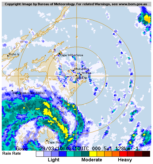
TC Paul is moving slowly southwest parallel to the Arnhem coast, south of
Nhulunbuy. A relatively large, ragged eye is evident on Gove radar. At 0000Z
re-assessed DT=4.0 with a 1.1 wrap. MET=4.0, PAT=4.0. Dvorak FT=4.0, with Vis
imagery since 00Z suggesting emergence of a Banding Eye pattern.
The broadscale environment remains favourable for further intensification, with
low vertical wind shear and good outflow to the south and north of the system.
The cyclone is forecast to move slowly west close to the coast during the next
6-12 hours and remain at similar intensity. While NWP still shows significant
longer-term divergence, a consensus has the TC move westwards initially, over
land, so slight weakening expected. Subsequently, the influence of a mid-level
ridge should see the low move eastwards again and move over Gulf waters in the
72 hour period, where rapid intensification may occur.
Copyright Commonwealth of Australia
==
The next bulletin for this system will be issued by: 29/0730 UTC by Darwin TCWC.
Issued by DARWIN TROPICAL CYCLONE WARNING CENTRE
at: 0228 UTC 29/03/2010
Name: Tropical Cyclone Paul
Identifier: 11U
Data At: 0000 UTC
Latitude: 13.3S
Longitude: 136.4E
Location Accuracy: within 15 nm [30 km]
Movement Towards: south southwest [194 deg]
Speed of Movement: 2 knots [4 km/h]
Maximum 10-Minute Wind: 50 knots [95 km/h]
Maximum 3-Second Wind Gust: 70 knots [130 km/h]
Central Pressure: 987 hPa
Radius of 34-knot winds NE quadrant: 60 nm [110 km]
Radius of 34-knot winds SE quadrant: 60 nm [110 km]
Radius of 34-knot winds SW quadrant: 45 nm [85 km]
Radius of 34-knot winds NW quadrant: 45 nm [85 km]
Radius of 48-knot winds NE quadrant: 20 nm [35 km]
Radius of 48-knot winds SE quadrant: 20 nm [35 km]
Radius of 48-knot winds SW quadrant: 20 nm [35 km]
Radius of 48-knot winds NW quadrant: 20 nm [35 km]
Radius of 64-knot winds:
Radius of Maximum Winds: 15 nm [30 km]
Dvorak Intensity Code: D4.0/4.0/1.0/24HRS
Pressure of outermost isobar: 1004 hPa
Radius of outermost closed isobar: 150 nm [280 km]
Storm Depth: Deep
FORECAST DATA
Date/Time : Location : Loc. Accuracy: Max Wind : Central Pressure
[UTC] : degrees : nm [km]: knots[km/h]: hPa
+12: 29/1200: 13.3S 136.0E: 045 [085]: 050 [095]: 985
+24: 30/0000: 13.3S 135.6E: 075 [140]: 040 [075]: 992
+36: 30/1200: 13.4S 135.5E: 110 [200]: 035 [065]: 995
+48: 31/0000: 13.7S 135.5E: 140 [260]: 030 [055]: 998
+60: 31/1200: 13.7S 136.7E: 190 [345]: 040 [075]: 993
+72: 01/0000: 13.9S 137.1E: 235 [435]: 050 [095]: 986
REMARKS:
TC Paul is moving slowly southwest parallel to the Arnhem coast, south of
Nhulunbuy. A relatively large, ragged eye is evident on Gove radar. At 0000Z
re-assessed DT=4.0 with a 1.1 wrap. MET=4.0, PAT=4.0. Dvorak FT=4.0, with Vis
imagery since 00Z suggesting emergence of a Banding Eye pattern.
The broadscale environment remains favourable for further intensification, with
low vertical wind shear and good outflow to the south and north of the system.
The cyclone is forecast to move slowly west close to the coast during the next
6-12 hours and remain at similar intensity. While NWP still shows significant
longer-term divergence, a consensus has the TC move westwards initially, over
land, so slight weakening expected. Subsequently, the influence of a mid-level
ridge should see the low move eastwards again and move over Gulf waters in the
72 hour period, where rapid intensification may occur.
Copyright Commonwealth of Australia
==
The next bulletin for this system will be issued by: 29/0730 UTC by Darwin TCWC.
0 likes

-
HurricaneBill
- Category 5

- Posts: 3419
- Joined: Sun Apr 11, 2004 5:51 pm
- Location: East Longmeadow, MA, USA
Re: GOC: TROPICAL CYCLONE PAUL (22P)
Small TCs near Australia have a tendency to spin up quickly.
0 likes


-
HURAKAN
- Professional-Met
- Posts: 46084
- Age: 39
- Joined: Thu May 20, 2004 4:34 pm
- Location: Key West, FL
- Contact:
Re: GOC: TROPICAL CYCLONE PAUL (22P)
Sanibel wrote:Getting that mean look but ran out of water.
It never has had too much water to work with
0 likes


-
HURAKAN
- Professional-Met
- Posts: 46084
- Age: 39
- Joined: Thu May 20, 2004 4:34 pm
- Location: Key West, FL
- Contact:
TROPICAL CYCLONE ADVICE NUMBER 20
Issued by the BUREAU OF METEOROLOGY, DARWIN
at 2:00 pm CST Monday 29 March 2010
A Cyclone WARNING continues for coastal and island communities from Milingimbi
to Numbulwar, including Nhulunbuy and Groote Eylandt.
A Cyclone WATCH continues for coastal and island communities west to Maningrida
and south to Port Roper.
At 12:30 pm CST Tropical Cyclone Paul, Category 2 was estimated to be 80
kilometres north of Alyangula and 125 kilometres south southwest of Nhulunbuy,
moving southwest at 4 kilometres per hour parallel to the coast.
The cyclone is currently close to the coast and is expected to move inland and
weaken slightly early on Tuesday.
DESTRUCTIVE WINDS with gusts to 140 kilometres per hour are likely on the coast
near Cape Shield as the cyclone moves inland.
GALES with gusts to 110 kilometres per hour are currently being experienced
between Nhulunbuy and Numbulwar, including Groote Eylandt. GALES may extend
north to Elcho Island and west to Milingimbi during Tuesday if the cyclone takes
a more northerly track. GALES may extend further west to Maningrida or south to
Port Roper during Wednesday, depending on the cyclone's future movement.
A STORM TIDE is expected between CAPE SHIELD and PORT ROPER. Tides are likely to
rise significantly above the normal high tide, with DAMAGING WAVES and DANGEROUS
FLOODING today and Tuesday.
HEAVY RAIN may lead to localised flooding and significant stream rises over the
eastern Top End and northern Roper-McArthur Districts today and Tuesday.
Details of Tropical Cyclone Paul at 12:30 pm CST:
.Centre located near...... 13.2 degrees South 136.3 degrees East
.Location accuracy........ within 30 kilometres
.Recent movement.......... towards the southwest at 4 kilometres per hour
.Wind gusts near centre... 140 kilometres per hour
.Severity category........ 2
.Central pressure......... 983 hectoPascals
The next advice will be issued by 5:00 pm CST Monday 29 March.
This advice is available on telephone NT-1300 659 211
DARWIN Tropical Cyclone Warning Centre
0 likes
-
Crostorm

- Category 5
- Posts: 2060
- Age: 51
- Joined: Mon Dec 25, 2006 3:51 pm
- Location: Croatia-Europe
- Contact:
Re: GOC: TROPICAL CYCLONE PAUL (22P)
IDDP0002
Australian Government Bureau of Meteorology
Northern Territory
Darwin Regional Forecasting Centre
TOP PRIORITY FOR IMMEDIATE BROADCAST
Media: The Standard Emergency Warning Signal should NOT be used with this
warning.
TROPICAL CYCLONE WARNING
TROPICAL CYCLONE ADVICE NUMBER 22
Issued by the BUREAU OF METEOROLOGY, DARWIN
at 7:26 pm CST Monday 29 March 2010
A Cyclone WARNING continues for coastal and island communities from Milingimbi
to Numbulwar, including Nhulunbuy and Groote Eylandt.
A Cyclone WATCH continues for coastal and island communities west to Maningrida
and south to Port McArthur.
At 6:30 pm CST Tropical Cyclone Paul, Category 2 was estimated to be 70
kilometres north northwest of Alyangula and 150 kilometres south southwest of
Nhulunbuy, moving southwest at 5 kilometres per hour.
The cyclone is currently close to the coast and is expected to move inland and
weaken slightly early on Tuesday. On Wednesday it is likely the cyclone will
move back into Gulf of Carpentaria where it may reintensify.
DESTRUCTIVE WINDS with gusts to 140 kilometres per hour are likely on the coast
near Cape Shield as the cyclone moves inland.
GALES with gusts to 110 kilometres per hour are currently being experienced
between Nhulunbuy and Numbulwar, including Groote Eylandt. GALES may extend
north to Elcho Island and west to Milingimbi during Tuesday if the cyclone takes
a more northerly track. GALES are likely to extend south to Port McArthur or
possibly west to Maningrida during Wednesday, depending on the cyclone's future
movement.
A STORM TIDE is expected between CAPE SHIELD and PORT ROPER. Tides are likely to
rise significantly above the normal high tide, with DAMAGING WAVES and DANGEROUS
FLOODING tonight and Tuesday.
HEAVY RAIN may lead to localised flooding and significant stream rises over the
eastern Top End and northern Roper-McArthur Districts tonight and Tuesday.
Details of Tropical Cyclone Paul at 6:30 pm CST:
.Centre located near...... 13.4 degrees South 136.1 degrees East
.Location accuracy........ within 30 kilometres
.Recent movement.......... towards the southwest at 5 kilometres per hour
.Wind gusts near centre... 140 kilometres per hour
.Severity category........ 2
.Central pressure......... 983 hectoPascals
The next advice will be issued by 11:00 pm CST Monday 29 March.
This advice is available on telephone NT-1300 659 211
DARWIN Tropical Cyclone Warning Centre
0 likes

-
HURAKAN
- Professional-Met
- Posts: 46084
- Age: 39
- Joined: Thu May 20, 2004 4:34 pm
- Location: Key West, FL
- Contact:
WTPS31 PGTW 290900
MSGID/GENADMIN/NAVMARFCSTCEN PEARL HARBOR HI/JTWC//
SUBJ/TROPICAL CYCLONE 22P (PAUL) WARNING NR 004//
RMKS/
1. TROPICAL CYCLONE 22P (PAUL) WARNING NR 004
01 ACTIVE TROPICAL CYCLONE IN SOUTHPAC
MAX SUSTAINED WINDS BASED ON ONE-MINUTE AVERAGE
WIND RADII VALID OVER OPEN WATER ONLY
---
WARNING POSITION:
290600Z --- NEAR 13.4S 136.2E
MOVEMENT PAST SIX HOURS - 245 DEGREES AT 02 KTS
POSITION ACCURATE TO WITHIN 060 NM
POSITION BASED ON CENTER LOCATED BY A COMBINATION OF
SATELLITE AND RADAR
PRESENT WIND DISTRIBUTION:
MAX SUSTAINED WINDS - 060 KT, GUSTS 075 KT
WIND RADII VALID OVER OPEN WATER ONLY
RADIUS OF 050 KT WINDS - 015 NM NORTHEAST QUADRANT
015 NM SOUTHEAST QUADRANT
015 NM SOUTHWEST QUADRANT
015 NM NORTHWEST QUADRANT
RADIUS OF 034 KT WINDS - 025 NM NORTHEAST QUADRANT
025 NM SOUTHEAST QUADRANT
030 NM SOUTHWEST QUADRANT
025 NM NORTHWEST QUADRANT
REPEAT POSIT: 13.4S 136.2E
---
FORECASTS:
12 HRS, VALID AT:
291800Z --- 13.5S 135.9E
MAX SUSTAINED WINDS - 060 KT, GUSTS 075 KT
WIND RADII VALID OVER OPEN WATER ONLY
RADIUS OF 050 KT WINDS - 015 NM NORTHEAST QUADRANT
015 NM SOUTHEAST QUADRANT
010 NM SOUTHWEST QUADRANT
010 NM NORTHWEST QUADRANT
RADIUS OF 034 KT WINDS - 025 NM NORTHEAST QUADRANT
025 NM SOUTHEAST QUADRANT
020 NM SOUTHWEST QUADRANT
020 NM NORTHWEST QUADRANT
VECTOR TO 24 HR POSIT: 250 DEG/ 02 KTS
---
24 HRS, VALID AT:
300600Z --- 13.6S 135.6E
MAX SUSTAINED WINDS - 050 KT, GUSTS 065 KT
WIND RADII VALID OVER OPEN WATER ONLY
VECTOR TO 36 HR POSIT: 250 DEG/ 03 KTS
---
36 HRS, VALID AT:
301800Z --- 13.8S 135.1E
MAX SUSTAINED WINDS - 035 KT, GUSTS 045 KT
WIND RADII VALID OVER OPEN WATER ONLY
DISSIPATING AS A SIGNIFICANT TROPICAL CYCLONE OVER LAND
---
REMARKS:
290900Z POSITION NEAR 13.4S 136.1E.
TROPICAL CYCLONE (TC) 22P (PAUL), LOCATED APPROXIMATELY 315 NM EAST
OF DARWIN, AUSTRALIA, HAS MOVED SLOWLY SOUTHWESTWARD AT 02 KNOTS OVER
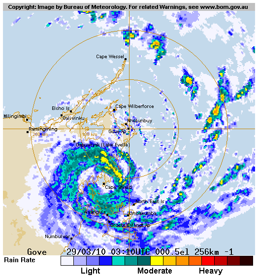
THE PAST SIX HOURS. ANIMATED INFRARED IMAGERY AND A RADAR LOOP FROM
GOVE, AUSTRALIA SHOW DEEP CONVECTIVE BANDING WRAPPING TIGHTLY AROUND
A LOW LEVEL CIRCULATION CENTER. INITIAL INTENSITY IS BASED ON DVORAK
ESTIMATES FROM PGTW, KNES, AND ADRM, AND EXTRAPOLATED FROM NEARBY
OBSERVING STATIONS. UPPER LEVEL ANALYSIS INDICATES TC 22P IS UNDER A
RIDGE AXIS IN AN AREA OF DIVERGENCE AND LOW VERTICAL WIND SHEAR, WITH
GOOD RADIAL OUTFLOW, AS EVIDENCED ON ANIMATED WATER VAPOR IMAGERY.
PAUL IS CURRENTLY TRACKING IN A WEAK STEERING ENVIRONMENT BETWEEN A
NEAR EQUATORIAL RIDGE AND A LOW- TO MID-LEVEL SUBTROPICAL RIDGE (STR)
TO THE SOUTH. THE STR APPEARS TO BE SLOWLY GAINING CONTROL, CAUSING
THE SYSTEM TO TURN SOUTHWESTWARD. TC 22P WILL MAINTAIN CURRENT
INTENSITY OVER THE NEXT 12 HOURS AS IT TRACKS OVER THE BLUE MUD BAY
BEFORE IT MAKES LANDFALL AND SLOWLY DISSIPATE AS A SIGNIFICANT
TROPICAL CYCLONE OVER LAND. THE AVAILABLE NUMERICAL MODEL GUIDANCE IS
IN POOR AGREEMENT DUE TO DIFFERENCES IN THE STEERING ENVIRONMENT
DEPICTION. MAXIMUM SIGNIFICANT WAVE HEIGHT AT 290600Z IS 16 FEET.
NEXT WARNINGS AT 292100Z AND 300900Z.//
NNNN
0 likes
-
HURAKAN
- Professional-Met
- Posts: 46084
- Age: 39
- Joined: Thu May 20, 2004 4:34 pm
- Location: Key West, FL
- Contact:
TROPICAL CYCLONE TECHNICAL BULLETIN: AUSTRALIA - NORTHERN REGION
Issued by DARWIN TROPICAL CYCLONE WARNING CENTRE
at: 1335 UTC 29/03/2010
Name: Tropical Cyclone Paul
Identifier: 11U
Data At: 1200 UTC
Latitude: 13.4S
Longitude: 136.0E
Location Accuracy: within 15 nm [30 km]
Movement Towards: west southwest [256 deg]
Speed of Movement: 2 knots [4 km/h]
Maximum 10-Minute Wind: 55 knots [100 km/h]
Maximum 3-Second Wind Gust: 75 knots [140 km/h]
Central Pressure: 982 hPa
Radius of 34-knot winds NE quadrant: 60 nm [110 km]
Radius of 34-knot winds SE quadrant: 60 nm [110 km]
Radius of 34-knot winds SW quadrant: 45 nm [85 km]
Radius of 34-knot winds NW quadrant: 45 nm [85 km]
Radius of 48-knot winds NE quadrant: 20 nm [35 km]
Radius of 48-knot winds SE quadrant: 20 nm [35 km]
Radius of 48-knot winds SW quadrant: 20 nm [35 km]
Radius of 48-knot winds NW quadrant: 20 nm [35 km]
Radius of 64-knot winds:
Radius of Maximum Winds: 15 nm [30 km]
Dvorak Intensity Code: T3.5/4.0 MINUS/D0.5/24HRS
Pressure of outermost isobar: 1004 hPa
Radius of outermost closed isobar: 150 nm [280 km]
Storm Depth: Deep
FORECAST DATA
Date/Time : Location : Loc. Accuracy: Max Wind : Central Pressure
[UTC] : degrees : nm [km]: knots[km/h]: hPa
+12: 30/0000: 13.3S 135.3E: 045 [085]: 040 [075]: 993
+24: 30/1200: 13.4S 135.0E: 075 [140]: 030 [055]: 997
+36: 31/0000: 13.5S 135.3E: 110 [200]: 030 [055]: 998
+48: 31/1200: 13.6S 135.9E: 140 [260]: 040 [075]: 992
+60: 01/0000: 13.8S 136.1E: 190 [345]: 045 [085]: 989
+72: 01/1200: 14.1S 136.6E: 235 [435]: 055 [100]: 983
REMARKS:
The cyclone is crossing the coast just south of Cape Shield. During Tuesday it
is expected to weaken as it remains over land. On Wednesday the influence of a
passing short wave trough to the south should see the ridge erode, and the low
is likely to move eastwards over Gulf waters again during Wednesday, with rapid
intensification possible. However some models indicate the ridge will not be
completely eroded and the system will remain over land. Alternatively if the
system weakens sufficiently quickly then the lower level steering winds will
move it westwards.
The DT was hovering between 3.5 and 4.0 in the images leading up to 12Z. MET is
3.5 and PAT agrees so FT is set at 3.5 with CI held to 4.0.
Aside from the influence of land, the broadscale environment remains favourable
for further intensification, with low vertical wind shear and good outflow,
particularly to the southeast of the system.
Copyright Commonwealth of Australia
==
The next bulletin for this system will be issued by: 29/1930 UTC by Darwin TCWC.
0 likes
Who is online
Users browsing this forum: No registered users and 38 guests