ATL: Ex COLIN - Discussion

Moderator: S2k Moderators

Message
Author
User avatar
wzrgirl1
Category 5
Category 5
Posts: 1246
Joined: Sat Sep 04, 2004 6:44 am
Location: Pembroke Pines, Florida

Re: ATL : INVEST 91L - DISCUSSION

#41 Postby wzrgirl1 » Sun Aug 01, 2010 6:48 am

cycloneye wrote:
wzrgirl1 wrote:My graphic still shows 40%...wonder why it didn't update.


It takes a few minutes to update.


Yes it did. I just have no patience. Let the real season begin. We need to pace ourselves because the next 10-12 days should be an emotional roller coaster for those in the islands and the east coast of US.
0 likes   

WeatherGuesser
Category 5
Category 5
Posts: 2672
Joined: Tue Jun 29, 2010 6:46 am

Re:

#42 Postby WeatherGuesser » Sun Aug 01, 2010 6:53 am

cwachal wrote:This reminds me of a storm that has plenty of time to strengthen even if it does it slowly we could still be looking at a major hurricane sometime during its path


Or one that whizzes itself out, turns and heads for the UK.
0 likes   

jinftl
Category 5
Category 5
Posts: 4312
Joined: Tue Aug 31, 2004 4:47 pm
Location: fort lauderdale, fl

Re: ATL : INVEST 91L - DISCUSSION

#43 Postby jinftl » Sun Aug 01, 2010 6:54 am

Probably the next 90 days will be a roller coaster....so far out, and with so much uncertainty it is way too soon to be too alarmed about this system, esp. when it isn't a td yet with an organized center. Not too soon to keep a watchful eye, though.

As a rule of thumb, once an area is in the 5-day 'cone of uncertainty', it is time to raise the level of attention and consider/begin preparation...until then, the margin of error once you get out beyond 120 hours is hundreds of miles and is basically speculation. Intensity forecasts beyond that timeframe are even more prone to error.


wzrgirl1 wrote:
cycloneye wrote:
wzrgirl1 wrote:My graphic still shows 40%...wonder why it didn't update.


It takes a few minutes to update.


Yes it did. I just have no patience. Let the real season begin. We need to pace ourselves because the next 10-12 days should be an emotional roller coaster for those in the islands and the east coast of US.
0 likes   

User avatar
srainhoutx
S2K Supporter
S2K Supporter
Posts: 6919
Age: 66
Joined: Sun Jan 14, 2007 11:34 am
Location: Haywood County, NC
Contact:

Re: ATL : INVEST 91L - DISCUSSION

#44 Postby srainhoutx » Sun Aug 01, 2010 6:57 am

HPC:

ATTENTION WILL LIKELY BE FOCUSED IN THE DAYS TO COME ON THE
POSSIBILITY OF A TROPICAL SYSTEM APPROACHING THE BAHAMAS LATE IN
THE PERIOD.
0 likes   
Carla/Alicia/Jerry(In The Eye)/Michelle/Charley/Ivan/Dennis/Katrina/Rita/Wilma/Ike/Harvey

Member: National Weather Association
Wx Infinity Forums
http://wxinfinity.com/index.php

Facebook.com/WeatherInfinity
Twitter @WeatherInfinity

User avatar
wzrgirl1
Category 5
Category 5
Posts: 1246
Joined: Sat Sep 04, 2004 6:44 am
Location: Pembroke Pines, Florida

Re: ATL : INVEST 91L - DISCUSSION

#45 Postby wzrgirl1 » Sun Aug 01, 2010 7:05 am

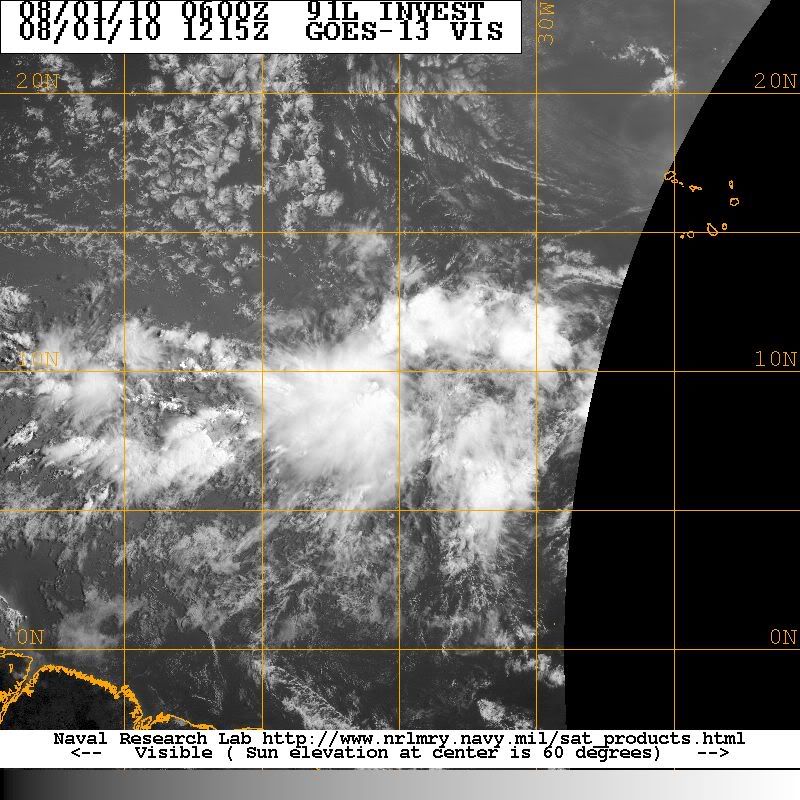
[quote="jinftl"]Probably the next 90 days will be a roller coaster....so far out, and with so much uncertainty it is way too soon to be too alarmed about this system, esp. when it isn't a td yet with an organized center. Not too soon to keep a watchful eye, though.

As a rule of thumb, once an area is in the 5-day 'cone of uncertainty', it is time to raise the level of attention and consider/begin preparation...until then, the margin of error once you get out beyond 120 hours is hundreds of miles and is basically speculation. Intensity forecasts beyond that timeframe are even more prone to error.


No worries. Not getting alarmed in any way. Just looking at the synoptics down the road and noticing a few things that spark my interest. With the high building, retreating, and then building again, makes for an interesting few days don't you think? You and I both being enthusiasts, and living in one of the highest percentages of hurricane targets (and pretty darn close to each other in proximity) :D will definitely be keeping a watchful eye I am sure.
0 likes   

User avatar
srainhoutx
S2K Supporter
S2K Supporter
Posts: 6919
Age: 66
Joined: Sun Jan 14, 2007 11:34 am
Location: Haywood County, NC
Contact:

Re: ATL : INVEST 91L - DISCUSSION

#46 Postby srainhoutx » Sun Aug 01, 2010 7:14 am

For the first 3-4 days, the track looks fairly straight forward. A W to WNW motion seems very reasonable. The very slow movement is interesting and worrisome for our Island neighbors.
0 likes   
Carla/Alicia/Jerry(In The Eye)/Michelle/Charley/Ivan/Dennis/Katrina/Rita/Wilma/Ike/Harvey

Member: National Weather Association
Wx Infinity Forums
http://wxinfinity.com/index.php

Facebook.com/WeatherInfinity
Twitter @WeatherInfinity

User avatar
Hurricane Andrew
S2K Supporter
S2K Supporter
Posts: 1891
Age: 25
Joined: Sun May 23, 2010 2:53 pm
Location: KS

#47 Postby Hurricane Andrew » Sun Aug 01, 2010 7:17 am

Does anyone think it might Do a recurve a bit to late and hit the EC? I go on vacation to Lancaster in 3 weeks. I don't need it to be wrecked.

FUrthermore, I LIVE 60 Miles N of NYC, so i don't need to be pounded with a Cat 3 hurricane.
0 likes   

The Enthusiast
NREMT-AEMT, WX nerd

Irene '11, Sandy '12, Irma '17 (SAR)

"Hard to think we were born to live this way..." -Wage War

jinftl
Category 5
Category 5
Posts: 4312
Joined: Tue Aug 31, 2004 4:47 pm
Location: fort lauderdale, fl

Re: ATL : INVEST 91L - DISCUSSION

#48 Postby jinftl » Sun Aug 01, 2010 7:18 am

Am i wrong to interpret the slow speed as an indication that the ridge steering it is not so strong? I recall waves/systems this far east being steered by strong ridges moving 15-20 mph, sometimes faster. Would that indicate that if this does develop well east of the islands, it is more likely to recurve (if the slow speed is a sign of a weak ridge steering it).

Have there been systems at 35W that were moving 5-10 mph that sped up and made it to the islands or u.s.?

srainhoutx wrote:For the first 3-4 days, the track looks fairly straight forward. A W to WNW motion seems very reasonable. The very slow movement is interesting and worrisome for our Island neighbors.
0 likes   

mountainfrog
Tropical Wave
Tropical Wave
Posts: 1
Joined: Sat Jun 19, 2010 9:55 am
Location: Samaná, Dominican Republic
Contact:

A Baddie in the Making

#49 Postby mountainfrog » Sun Aug 01, 2010 7:18 am

Hmm, I don't trust that thing.
It's now high enough to get kicked into a spin, the ocean is 'hot' for fuelling, no wind shears in sight.
Lot of time to strengthen and do damage in our Caribbean islands.
It does not look good. :(

m'frog
0 likes   

User avatar
Hurricane Andrew
S2K Supporter
S2K Supporter
Posts: 1891
Age: 25
Joined: Sun May 23, 2010 2:53 pm
Location: KS

#50 Postby Hurricane Andrew » Sun Aug 01, 2010 7:20 am

@Mountain Frog-Yeah, it looks like the N carribean islands will get Pounded. get your hurricane Plans ready!
Last edited by Hurricane Andrew on Sun Aug 01, 2010 7:33 am, edited 1 time in total.
0 likes   

The Enthusiast
NREMT-AEMT, WX nerd

Irene '11, Sandy '12, Irma '17 (SAR)

"Hard to think we were born to live this way..." -Wage War

jinftl
Category 5
Category 5
Posts: 4312
Joined: Tue Aug 31, 2004 4:47 pm
Location: fort lauderdale, fl

Re:

#51 Postby jinftl » Sun Aug 01, 2010 7:25 am

Way too soon to say anyone is going to get pounded by an invest 1500+ miles east of the islands which is moving 5-10 mph and isn't organized enough yet to even be a 30 mph td....don't you think?

Many invests come off the coast of africa each season...and lots can happen in the next week....of course hurricane plans should be ready on June 1, but there is a difference between being vigilant and prepared and making dire predictions of doom and gloom this far out.

Hurricane Andrew wrote:@Mountain Frog-Yeah, it looks like the N carribean islands will get Pounded. get your hurricane Plans ready!
0 likes   

lonelymike
S2K Supporter
S2K Supporter
Posts: 634
Joined: Sat Jul 26, 2008 10:12 am
Location: walton county fla

Re: ATL : INVEST 91L - DISCUSSION

#52 Postby lonelymike » Sun Aug 01, 2010 7:31 am

Anybody got a nifty hurricane history map of systems that formed around this area?
0 likes   


GO SEMINOLES

User avatar
srainhoutx
S2K Supporter
S2K Supporter
Posts: 6919
Age: 66
Joined: Sun Jan 14, 2007 11:34 am
Location: Haywood County, NC
Contact:

Re: ATL : INVEST 91L - DISCUSSION

#53 Postby srainhoutx » Sun Aug 01, 2010 7:47 am

Latest 2km View

Image
0 likes   
Carla/Alicia/Jerry(In The Eye)/Michelle/Charley/Ivan/Dennis/Katrina/Rita/Wilma/Ike/Harvey

Member: National Weather Association
Wx Infinity Forums
http://wxinfinity.com/index.php

Facebook.com/WeatherInfinity
Twitter @WeatherInfinity

User avatar
cycloneye
Admin
Admin
Posts: 139593
Age: 67
Joined: Thu Oct 10, 2002 10:54 am
Location: San Juan, Puerto Rico

Re: ATL : INVEST 91L - DISCUSSION

#54 Postby cycloneye » Sun Aug 01, 2010 7:49 am

12z Best Track

AL, 91, 2010080112, , BEST, 0, 91N, 354W, 25, 1008, LO

ftp://ftp.tpc.ncep.noaa.gov/atcf/tcweb/ ... 010.invest
0 likes   
Visit the Caribbean-Central America Weather Thread where you can find at first post web cams,radars
and observations from Caribbean basin members Click Here

jlauderdal
S2K Supporter
S2K Supporter
Posts: 6810
Joined: Wed May 19, 2004 5:46 am
Location: NE Fort Lauderdale
Contact:

Re:

#55 Postby jlauderdal » Sun Aug 01, 2010 7:51 am

Hurricane Andrew wrote:Does anyone think it might Do a recurve a bit to late and hit the EC? I go on vacation to Lancaster in 3 weeks. I don't need it to be wrecked.

FUrthermore, I LIVE 60 Miles N of NYC, so i don't need to be pounded with a Cat 3 hurricane.


if we new that we would be zillionzires, its too far out, 5 days is about max for anything reliable and that has a 300 mile error on nhc track
0 likes   

clfenwi
Category 5
Category 5
Posts: 3331
Joined: Thu Jun 09, 2005 12:54 pm

Re: ATL : INVEST 91L - DISCUSSION

#56 Postby clfenwi » Sun Aug 01, 2010 7:58 am

lonelymike wrote:Anybody got a nifty hurricane history map of systems that formed around this area?


All-time tropical depression and storms that were within 2° of 91L's 12Z best track position:

Image

Created with NOAA's hurricane historical tracks.
0 likes   

User avatar
cycloneye
Admin
Admin
Posts: 139593
Age: 67
Joined: Thu Oct 10, 2002 10:54 am
Location: San Juan, Puerto Rico

Re: ATL : INVEST 91L - DISCUSSION

#57 Postby cycloneye » Sun Aug 01, 2010 8:07 am

clfenwi wrote:
lonelymike wrote:Anybody got a nifty hurricane history map of systems that formed around this area?


All-time tropical depression and storms that were within 2° of 91L's 12Z best track position:

http://img340.imageshack.us/img340/4945/91lclimatology08011200.png

Created with NOAA's hurricane historical tracks.


There are very powerful ones in those tracks.
0 likes   
Visit the Caribbean-Central America Weather Thread where you can find at first post web cams,radars
and observations from Caribbean basin members Click Here

User avatar
cycloneye
Admin
Admin
Posts: 139593
Age: 67
Joined: Thu Oct 10, 2002 10:54 am
Location: San Juan, Puerto Rico

Re: ATL : INVEST 91L - DISCUSSION

#58 Postby cycloneye » Sun Aug 01, 2010 8:09 am

SSD first dvorak T numbers for 91L.

01/1200 UTC 8.7N 34.4W T1.5/1.5 91L -- Atlantic
0 likes   
Visit the Caribbean-Central America Weather Thread where you can find at first post web cams,radars
and observations from Caribbean basin members Click Here

User avatar
OverlandHurricane
S2K Supporter
S2K Supporter
Posts: 58
Joined: Thu Aug 28, 2008 4:50 pm
Location: Minnesota

Re: ATL : INVEST 91L - DISCUSSION

#59 Postby OverlandHurricane » Sun Aug 01, 2010 8:13 am

clfenwi wrote:
lonelymike wrote:Anybody got a nifty hurricane history map of systems that formed around this area?


All-time tropical depression and storms that were within 2° of 91L's 12Z best track position:

Created with NOAA's hurricane historical tracks.


Yep, there are some blockbusters on that map. Inez, Allen, Andrew, Georges, Ivan the Terrible, Frances...

Also, thank you for linking to the Historic Hurricane Track interactive map. I had no idea that such a thing existed.
0 likes   

User avatar
Aquawind
Category 5
Category 5
Posts: 6714
Age: 60
Joined: Mon Jun 16, 2003 10:41 pm
Location: Salisbury, NC
Contact:

#60 Postby Aquawind » Sun Aug 01, 2010 8:16 am

Those were some mean Hurricanes..We need King TUTT and Mr Shear to join the party and hang with Collin for a couple weeks. Stay Safe Islanders! Warming tops ATM soo slow and westward unfortunately..
0 likes   


Return to “2010”

Who is online

Users browsing this forum: No registered users and 26 guests