Date: Sep 06 23:01:00 EDT
Type: Tropical Storm
City: Brownsville
County: Cameron
State: TX
Source: Broadcast Media
Details: Media weatherbug station at Lone
Star National Bank in Brownsville reports
Gust to 53 mph. Time is Approx.
ATL: Ex-Tropical Storm HERMINE - Discussion
Moderator: S2k Moderators
10PM CDT regional obs showing winds picking up:
TXZ248>255-070400-
DEEP SOUTH TEXAS
CITY SKY/WX TMP DP RH WIND PRES REMARKS
BROWNSVILLE HVY RAIN 80 76 87 E23G31 29.63F FOG
PORT ISABEL LGT RAIN 83 78 85 E18G30 29.70S HX 93
*SOUTH PADRE CLOUDY 82 77 83 E36G46 29.68F HX 91
HARLINGEN RAIN 79 75 89 NE14G20 29.70F
*HEBBRONVILLE CLOUDY 80 74 82 E14G20 29.82R
MCALLEN LGT RAIN 80 76 87 NE13 29.73F
*WESLACO RAIN 77 75 93 NE15G22 29.72F
FALFURRIAS CLOUDY 81 77 88 E12 29.78R
EDINBURG RAIN 80 77 90 E12 29.75S
*ZAPATA CLOUDY 79 74 83 CALM 29.79R
Here's the METAR for Brownsville that Aric noted:
KBRO 070313Z 08031G44KT 1 3/4SM +RA BR BKN012 BKN019 OVC027 26/24 A2960 RMK AO2 PK WND 08044/0307 PRESFR P0021
And from S Padre Island:
KSPL 070335Z AUTO 09038G45KT 27/25 A2968 RMK AO2 PWINO PNO
0 likes

Yep. Edge of circulation just at the border. TS hit for Brownsville and the US even if it's courtesy of 1 if by land. That makes 2 hits, 4 TS condition US events (Alex, Bonnie, Hermine, Earl) and 2 or 3 unclassified TD conditions thus far. That's fairly busy for any season. But we've got a while to go yet.
0 likes
-
Aric Dunn
- Category 5

- Posts: 21238
- Age: 43
- Joined: Sun Sep 19, 2004 9:58 pm
- Location: Ready for the Chase.
- Contact:
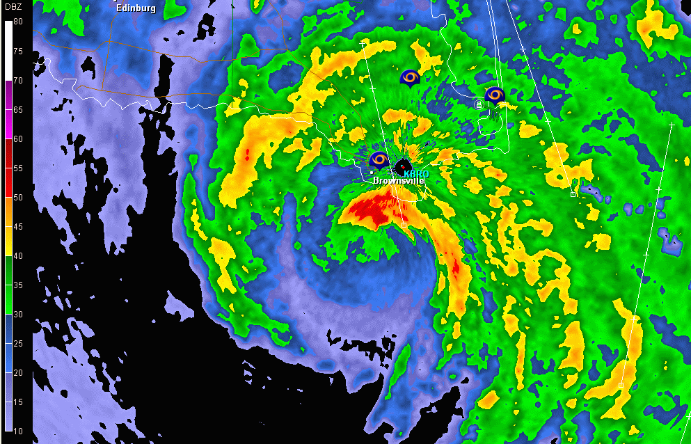
its maintaining quite well ... most of the circ is still over water.. which is what i figured would happen because its angle of approach to the coast.
well the edge of the max winds in the doppler velocities are almost to texas ans Brownsville .. next 20 minutes they should hit the NWS and some reporting stations then we will see if the 60 to 70 kts swath I see is close or not..
well the edge of the max winds in the doppler velocities are almost to texas ans Brownsville .. next 20 minutes they should hit the NWS and some reporting stations then we will see if the 60 to 70 kts swath I see is close or not..
Last edited by Aric Dunn on Mon Sep 06, 2010 10:48 pm, edited 1 time in total.
0 likes
Note: If I make a post that is brief. Please refer back to previous posts for the analysis or reasoning. I do not re-write/qoute what my initial post said each time.
If there is nothing before... then just ask
Space & Atmospheric Physicist, Embry-Riddle Aeronautical University,
I believe the sky is falling...
If there is nothing before... then just ask
Space & Atmospheric Physicist, Embry-Riddle Aeronautical University,
I believe the sky is falling...
-
Houstonia

- S2K Supporter

- Posts: 829
- Age: 61
- Joined: Fri Oct 11, 2002 9:45 am
- Location: Sharpstown, Houston, Harris County, Southeast Texas.
Re:
Texashawk wrote:I swear this thing is going north again... maybe even a touch NNE... looks like it might go directly over Brownsville... could be interesting if it keeps going just a touch east of north...
Gene Norman on Houston's KHOU is saying there is concern that Hermine might move back out over water and follow the coastline north. Of course Gene Norman can sometimes blow things out of proportion...
0 likes
-
Dave

- Retired Staff

- Posts: 13442
- Age: 75
- Joined: Tue Aug 01, 2006 3:57 pm
- Location: Milan Indiana
- Contact:
Going to drop this warning here considering most are watching this thread...
BULLETIN - EAS ACTIVATION REQUESTED
TORNADO WARNING
NATIONAL WEATHER SERVICE BROWNSVILLE TX
1048 PM CDT MON SEP 6 2010
THE NATIONAL WEATHER SERVICE IN BROWNSVILLE HAS ISSUED A
* TORNADO WARNING FOR...
SOUTHERN CAMERON COUNTY IN DEEP SOUTH TEXAS.
* UNTIL 1115 PM CDT
* AT 1048 PM CDT...NATIONAL WEATHER SERVICE DOPPLER RADAR INDICATED A
TORNADO 6 MILES NORTHEAST OF BROWNSVILLE...MOVING NORTHWEST AT 60
MPH.
* THE TORNADO WILL BE NEAR...
BROWNSVILLE.
OLMITO.
RANCHO VIEJO.
SAN BENITO.
HARLINGEN.
0 likes
-
Texashawk

- Category 2

- Posts: 579
- Joined: Tue Aug 14, 2007 1:50 am
- Location: Missouri City, TX (Houston)
Re: Re:
Houstonia wrote:Texashawk wrote:I swear this thing is going north again... maybe even a touch NNE... looks like it might go directly over Brownsville... could be interesting if it keeps going just a touch east of north...
Gene Norman on Houston's KHOU is saying there is concern that Hermine might move back out over water and follow the coastline north. Of course Gene Norman can sometimes blow things out of proportion...
Oh, that wacky Gene!!! We love him.
0 likes
-
Aric Dunn
- Category 5
- Posts: 21238
- Age: 43
- Joined: Sun Sep 19, 2004 9:58 pm
- Location: Ready for the Chase.
- Contact:
67 mph at grand isle resort south padre island ... I imagine stronger winds are farther south just no reporting stations are there to report.. there is probably hurricane force winds near Brownsville on the coast..
0 likes
Note: If I make a post that is brief. Please refer back to previous posts for the analysis or reasoning. I do not re-write/qoute what my initial post said each time.
If there is nothing before... then just ask
Space & Atmospheric Physicist, Embry-Riddle Aeronautical University,
I believe the sky is falling...
If there is nothing before... then just ask
Space & Atmospheric Physicist, Embry-Riddle Aeronautical University,
I believe the sky is falling...
-
WeatherGuesser
- Category 5
- Posts: 2672
- Joined: Tue Jun 29, 2010 6:46 am
Re: ATL: Tropical Storm HERMINE - Discussion
wxman57 wrote:I think Hurricane Hermine will move ashore just north of Brownsville tomorrow morning. Fairly confident landfall won't be north of Corpus.
Never did make H1, and came in s/o BRO
utweather wrote:Wow! I think most of us here were looking thousands of miles away in the Atlantic, checking out SAL and anything else, every once in while one of the models would show something in the western gulf but we'd say what is that and ignore it, but lo and behold something forms out of nowhere right under our noses, crazy
At least one of us was watching this several days ago in the Pacific before it crossed over and as it crossed over.
0 likes
-
Aric Dunn
- Category 5
- Posts: 21238
- Age: 43
- Joined: Sun Sep 19, 2004 9:58 pm
- Location: Ready for the Chase.
- Contact:
the NWS this hour has sustained at 45 gusting to 61 mph
0 likes
Note: If I make a post that is brief. Please refer back to previous posts for the analysis or reasoning. I do not re-write/qoute what my initial post said each time.
If there is nothing before... then just ask
Space & Atmospheric Physicist, Embry-Riddle Aeronautical University,
I believe the sky is falling...
If there is nothing before... then just ask
Space & Atmospheric Physicist, Embry-Riddle Aeronautical University,
I believe the sky is falling...
-
Aric Dunn
- Category 5
- Posts: 21238
- Age: 43
- Joined: Sun Sep 19, 2004 9:58 pm
- Location: Ready for the Chase.
- Contact:
matching pretty well with radar estimates.. after a little reduction... there is still likely hurricane force gust along the coast..
0 likes
Note: If I make a post that is brief. Please refer back to previous posts for the analysis or reasoning. I do not re-write/qoute what my initial post said each time.
If there is nothing before... then just ask
Space & Atmospheric Physicist, Embry-Riddle Aeronautical University,
I believe the sky is falling...
If there is nothing before... then just ask
Space & Atmospheric Physicist, Embry-Riddle Aeronautical University,
I believe the sky is falling...
-
blazess556
- Professional-Met

- Posts: 250
- Joined: Mon Aug 31, 2009 10:51 pm
- Location: Germantown, MD
-
Aric Dunn
- Category 5
- Posts: 21238
- Age: 43
- Joined: Sun Sep 19, 2004 9:58 pm
- Location: Ready for the Chase.
- Contact:
Re:
blazess556 wrote:Gusts to 69 mph at BRO
yep you beat me too its well inland too.. there could easily be 75 to even 80 along the coast.
0 likes
Note: If I make a post that is brief. Please refer back to previous posts for the analysis or reasoning. I do not re-write/qoute what my initial post said each time.
If there is nothing before... then just ask
Space & Atmospheric Physicist, Embry-Riddle Aeronautical University,
I believe the sky is falling...
If there is nothing before... then just ask
Space & Atmospheric Physicist, Embry-Riddle Aeronautical University,
I believe the sky is falling...
-
dwsqos2
Re: ATL: Tropical Storm HERMINE - Discussion
Given that KBRO doesn't have marine exposure, I'm kind of impressed.
0 likes
The 11PM CDT obs from the South Texas Regional Weather Roundup:
TXZ248>255-070500-
DEEP SOUTH TEXAS
CITY SKY/WX TMP DP RH WIND PRES REMARKS
BROWNSVILLE HVY RAIN 79 77 94 E45G61 29.53F FOG
PORT ISABEL RAIN 82 77 84 E33G51 29.66F HX 90
*SOUTH PADRE N/A 81 77 89 E46G54 29.67F
HARLINGEN RAIN 79 75 89 E22G35 29.67F FOG
*HEBBRONVILLE LGT RAIN 78 75 92 E14 29.84R
MCALLEN LGT RAIN 78 76 93 NE13 29.72F
*WESLACO LGT RAIN 77 75 94 NE14G20 29.69F
FALFURRIAS CLOUDY 80 76 87 E12 29.79S
EDINBURG LGT RAIN 79 76 90 E13G26 29.74F
*ZAPATA CLOUDY 80 74 84 NE3 29.81R
$$
TXZ213>215-236>238-242>244-246-247-251-254-255-070500-
CMAN STATIONS
STATION/POSITION TIME TEMP WIND PRES WAVE
AIR SEA DIR/SP/G HT/PER
(UTC) (F) (DEG/KT/KT) (MB) (FT/S)
SABINE PASS 0400 84 86 130/ 16/ 19 1015.3
SEA RIM ST PARK 0300 83 120/ 14/ 18 1014.1
GALVESTON PIER 0400 85 84 110/ 19/ 23 N/A
EAGLE POINT 0400 84 83 120/ 17/ 19 1013.8
MORGANS POINT 0400 83 83 110/ 12/ 14 1012.4
PORT O`CONNOR 0300 84 140/ 18/ 21 N/A
PORT ARANSAS 0300 81 86 110/ 19/ 22 1010.4
MALAQUITE BEACH 0400 79 85 110/ 21/ 25 N/A
BAFFIN BAY 0300 80/ 21/ 24 N/A
PORT ISABEL 0400 79 85 110/ 34/ 43 1005.0
$$
And the METAR reported above showing Brownsville with winds E 44 mph gusting to 69 mph:
KBRO 070401Z 11038G60KT 1 3/4SM +RA BR SCT011 BKN016 OVC025 26/24 A2951 RMK AO2 PK WND 12060/0401 P0002
0 likes
-
Aric Dunn
- Category 5
- Posts: 21238
- Age: 43
- Joined: Sun Sep 19, 2004 9:58 pm
- Location: Ready for the Chase.
- Contact:
widespread power outages reported in and around brownsville.
0 likes
Note: If I make a post that is brief. Please refer back to previous posts for the analysis or reasoning. I do not re-write/qoute what my initial post said each time.
If there is nothing before... then just ask
Space & Atmospheric Physicist, Embry-Riddle Aeronautical University,
I believe the sky is falling...
If there is nothing before... then just ask
Space & Atmospheric Physicist, Embry-Riddle Aeronautical University,
I believe the sky is falling...
Who is online
Users browsing this forum: No registered users and 57 guests