827
wtps31 pgtw 262100
msgid/genadmin/navmarfcstcen Pearl Harbor hi/jtwc//
subj/tropical cyclone 09p (olga) warning nr 005//
ref/a/msg/navmarfcstcen Pearl Harbor hi/261721zjan2010//
ampn/ref a is a tropical cyclone formation alert.//
Subj: tropical cyclone 09p (olga) warning nr 005
1. Tropical cyclone 09p (olga) warning nr 005
01 active tropical cyclone in southpac
Max sustained winds based on one-minute average
wind radii valid over open water only
---
warning position:
261800z --- near 16.4s 137.9e
movement past six hours - 325 degrees at 07 kts
position accurate to within 060 nm
position based on center located by a combination of
satellite, radar and synoptic data
present wind distribution:
Max sustained winds - 035 kt, gusts 045 kt
wind radii valid over open water only
repeat posit: 16.4s 137.9e
---
forecasts:
12 hrs, valid at:
270600z --- 15.7s 137.0e
Max sustained winds - 040 kt, gusts 050 kt
wind radii valid over open water only
radius of 034 kt winds - 040 nm northeast quadrant
040 nm southeast quadrant
040 nm southwest quadrant
040 nm northwest quadrant
vector to 24 hr posit: 330 deg/ 03 kts
---
24 hrs, valid at:
271800z --- 15.2s 136.7e
Max sustained winds - 045 kt, gusts 055 kt
wind radii valid over open water only
radius of 034 kt winds - 045 nm northeast quadrant
045 nm southeast quadrant
045 nm southwest quadrant
045 nm northwest quadrant
vector to 36 hr posit: 075 deg/ 02 kts
---
36 hrs, valid at:
280600z --- 15.1s 137.1e
Max sustained winds - 055 kt, gusts 070 kt
wind radii valid over open water only
radius of 050 kt winds - 020 nm northeast quadrant
020 nm southeast quadrant
020 nm southwest quadrant
020 nm northwest quadrant
radius of 034 kt winds - 050 nm northeast quadrant
050 nm southeast quadrant
050 nm southwest quadrant
050 nm northwest quadrant
vector to 48 hr posit: 105 deg/ 02 kts
---
extended outlook:
48 hrs, valid at:
281800z --- 15.2s 137.5e
Max sustained winds - 065 kt, gusts 080 kt
wind radii valid over open water only
radius of 050 kt winds - 035 nm northeast quadrant
025 nm southeast quadrant
025 nm southwest quadrant
035 nm northwest quadrant
radius of 034 kt winds - 065 nm northeast quadrant
045 nm southeast quadrant
045 nm southwest quadrant
065 nm northwest quadrant
vector to 72 hr posit: 125 deg/ 05 kts
---
72 hrs, valid at:
291800z --- 16.2s 139.1e
Max sustained winds - 080 kt, gusts 100 kt
wind radii valid over open water only
radius of 064 kt winds - 025 nm northeast quadrant
020 nm southeast quadrant
020 nm southwest quadrant
025 nm northwest quadrant
radius of 050 kt winds - 040 nm northeast quadrant
030 nm southeast quadrant
030 nm southwest quadrant
040 nm northwest quadrant
radius of 034 kt winds - 075 nm northeast quadrant
050 nm southeast quadrant
055 nm southwest quadrant
075 nm northwest quadrant
vector to 96 hr posit: 130 deg/ 09 kts
---
long range outlook:
note...errors for track have averaged near 250 nm
on day 4 and 350 nm on day 5... and for intensity
near 20 kt each day.
---
96 hrs, valid at:
301800z --- 18.6s 142.1e
Max sustained winds - 060 kt, gusts 075 kt
wind radii valid over open water only
dissipating as a significant tropical cyclone over land
vector to 120 hr posit: 145 deg/ 11 kts
---
120 hrs, valid at:
311800z --- 22.4s 144.8e
Max sustained winds - 030 kt, gusts 040 kt
wind radii valid over open water only
dissipated as a significant tropical cyclone over land
---
remarks:
262100z position near 16.2s 137.7e.
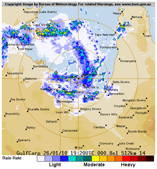
Tropical cyclone (tc) 09p (olga), located approximately 100 nm
west of Mornington Island, has tracked northwestward at 07 knots
over the past six hours. Animated infrared satellite imagery, radar
imagery from the Mornington Island radar, and a 261628z AMSR-E 85 ghz
microwave image indicate that the system has regenerated along the
southern coast of the Gulf of Carpentaria with improved
consolidation and tightly curved banding wrapping into the low level
circulation center (LLCC). The current intensity is based on Dvorak
estimates ranging from 30 to 35 knots from adrm and pgtw. The system
is currently located in a region of high SST (31c) and favorable ohc
values. Upper level analysis indicates that the system is under an
upper level anticyclone with weak vertical wind shear and good
radial outflow. The system is currently tracking northwestward along
the northern periphery of a low to mid level subtropical ridge (str)
over central Australia. The str is expected to build northwestward
after tau 12, therefore, the system is forecast to slow and turn
north to northeastward. By tau 48 a deepening shortwave trough will
break down the str and, in combination with the near-equatorial
ridge, provide an eastward to southeastward steering influence. Tc
09p is expected to slowly intensify through tau 24 due to continued
land interaction, but is forecast to intensify at a 15-20 knot rate
per day under very favorable conditions. After tau 72 the system is
expected to weaken as it interacts with land and should dissipate
by tau 120. Numerical model guidance is in good agreement with this
forecast although there are slight differences in the timing of the
turn eastward. This warning supersedes and cancels ref a,
navmarfcstcen 261721z Jan 10 tropical cyclone formation alert


