ATL: MATTHEW - Ex-Tropical Storm - Discussion

Moderator: S2k Moderators

Message
Author
User avatar
cycloneye
Admin
Admin
Posts: 139339
Age: 67
Joined: Thu Oct 10, 2002 10:54 am
Location: San Juan, Puerto Rico

Re: ATL : INVEST 95L - Discussion

#61 Postby cycloneye » Tue Sep 21, 2010 11:54 am

tgenius wrote:
cycloneye wrote:The squadron is not waiting two days to start missions towards 95L as the first TCPOD released today has the first mission for tommorow afternoon. See the complete TCPOD at 95L recon thread. viewtopic.php?f=59&t=109486&p=2071564#p2071564


Luis, does that lead you to believe they feel the threat is significant from this?


It looks like they see this as a big threat and dont want to wait longer to start investigating it.
0 likes   
Visit the Caribbean-Central America Weather Thread where you can find at first post web cams,radars
and observations from Caribbean basin members Click Here

User avatar
KWT
Category 5
Category 5
Posts: 31391
Joined: Tue Aug 17, 2004 11:02 am
Location: UK!!!

#62 Postby KWT » Tue Sep 21, 2010 11:57 am

Not all that surprising they've got recon ready, given the models are quite supportive of this becoming a decent system...

The models will be all over the place the next few days, there are many different variables that could have a role on strength/track down the line...

At least the next 2-3 days are easy, just a little north of west (maybe 275-280) and steadily strengthening, IMO probably into a TS before it gets close to CA.
0 likes   
Personal Forecast Disclaimer:
The posts in this forum are NOT official forecast and should not be used as such. They are just the opinion of the poster and may or may not be backed by sound meteorological data. They are NOT endorsed by any professional institution or storm2k.org. For official information, please refer to the NHC and NWS products

Vortmax1
Category 1
Category 1
Posts: 360
Joined: Wed Jul 07, 2010 11:35 pm
Location: Port Salerno, FL
Contact:

#63 Postby Vortmax1 » Tue Sep 21, 2010 12:04 pm

The tropics may make up for lost time in terms of direct impacts from tropical storms and/or hurricanes on the U.S., as the nearby waters of the Gulf of Mexico, Caribbean and the southwestern Atlantic are primed to explode during October.


Image


October may be the month the southeastern U.S. is battered by multiple tropical storms or hurricanes.

AccuWeather.com Hurricane Expert Joe Bastardi remains very concerned that the raging La Niña and its associated cool waters in the tropical Pacific have created a tremendous imbalance.


more.....

http://www.accuweather.com/blogs/news/s ... -in-th.asp
Last edited by Vortmax1 on Tue Sep 21, 2010 12:12 pm, edited 1 time in total.
0 likes   

ospreygrad
Tropical Low
Tropical Low
Posts: 43
Joined: Mon Sep 20, 2010 10:43 am
Location: Jacksonville, FL

Re:

#64 Postby ospreygrad » Tue Sep 21, 2010 12:08 pm

Vortmax1 wrote:The tropics may make up for lost time in terms of direct impacts from tropical storms and/or hurricanes on the U.S., as the nearby waters of the Gulf of Mexico, Caribbean and the southwestern Atlantic are primed to explode during October.


Image


October may be the month the southeastern U.S. is battered by multiple tropical storms or hurricanes.

AccuWeather.com Hurricane Expert Joe Bastardi remains very concerned that the raging La Niña and its associated cool waters in the tropical Pacific have created a tremendous imbalance.


more.....http://www.accuweather.com/blo ... -in-th.asp


Thanks for posting this. Yep, the La Nina really has me concerned about the remainder of the hurricane season here in Florida and along the Gulf and SE Atlatic coasts. I have an unsettling feeling that the worst is still to come.
0 likes   

Vortmax1
Category 1
Category 1
Posts: 360
Joined: Wed Jul 07, 2010 11:35 pm
Location: Port Salerno, FL
Contact:

#65 Postby Vortmax1 » Tue Sep 21, 2010 12:14 pm

There is always some truth in what Joe B has to say.
I have also been concerned about the heat content.
It has to go somewhere so it won't just stay trapped in the tropics forever.
0 likes   

CrazyC83
Professional-Met
Professional-Met
Posts: 33393
Joined: Tue Mar 07, 2006 11:57 pm
Location: Deep South, for the first time!

#66 Postby CrazyC83 » Tue Sep 21, 2010 12:16 pm

My early prediction for the rest of September and October: 4/3/2 (one of them a strong Cat 5). For November, I am thinking 1 more named storm, which I think will be a major hurricane.
0 likes   

User avatar
KWT
Category 5
Category 5
Posts: 31391
Joined: Tue Aug 17, 2004 11:02 am
Location: UK!!!

#67 Postby KWT » Tue Sep 21, 2010 12:17 pm

Well actually the heat content can stayed trapped and instead of all being blown off at once by a hurricane slow upwelling over the period of months with a particular type of pattern would be just as effective as well...

Still this does look like a rather typical La Nina type system, esp if it takes till say 75-80W to develop...

SE States and the Gulf coast need to keep a close eye on it, though for now the threat to the west Gulf seems to be reducing...
0 likes   
Personal Forecast Disclaimer:
The posts in this forum are NOT official forecast and should not be used as such. They are just the opinion of the poster and may or may not be backed by sound meteorological data. They are NOT endorsed by any professional institution or storm2k.org. For official information, please refer to the NHC and NWS products

User avatar
ColinDelia
S2K Supporter
S2K Supporter
Posts: 918
Joined: Mon Aug 29, 2005 5:52 am
Location: The Beach, FL

Re: ATL : INVEST 95L - Discussion

#68 Postby ColinDelia » Tue Sep 21, 2010 12:21 pm

Any thoughts on the upper air environment? There's a ULL to the NE which looks like it won't move all that much or be much of a player in 95 L's future.

The GFS forecasts an upper level high to form over Hispaniola in about 24 hours and for 95L to be on the southern or southeastern edge of this high (and so not directly under it). I believe that TCs a good distance to the Southeast of a 200 mb high tend to be slow developers. I remember this from a paper I am pretty sure but have to go digging for it.

Reminds me of when the GFS had Gaston at the edge of that upper level high and hence wasn't under it. In opposition to the statistical models the GFS didn't develop Gaston and ended up verifying.

An argument for slow development the next few days in accordance with the globals? (Not bombing anyway)

But then the 200 mb high hasn't formed over Hispaniola yet and one wonder whether one is forming over 95 as we speak. now that I just contradicted myself ...

Thoughts and criticism welcome especially what would the logic be for developing TCs in physical relation to upper level highs? That's above my pay rank ;-)
0 likes   

Vortmax1
Category 1
Category 1
Posts: 360
Joined: Wed Jul 07, 2010 11:35 pm
Location: Port Salerno, FL
Contact:

#69 Postby Vortmax1 » Tue Sep 21, 2010 12:28 pm

I understand what you're saying KWT.
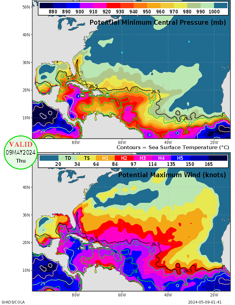
But there's a pressure cooker going in the Caribbean right now and the quick relief valve is a tropical cyclone.


Image
0 likes   

ospreygrad
Tropical Low
Tropical Low
Posts: 43
Joined: Mon Sep 20, 2010 10:43 am
Location: Jacksonville, FL

#70 Postby ospreygrad » Tue Sep 21, 2010 12:31 pm

My goodness, look at the potential fuel in the form of ocean heat content sitting in the NW Caribbean Sea right now. Any tropical cyclone that could be in that region can really explode right now.
0 likes   

User avatar
KWT
Category 5
Category 5
Posts: 31391
Joined: Tue Aug 17, 2004 11:02 am
Location: UK!!!

#71 Postby KWT » Tue Sep 21, 2010 12:36 pm

Yep indeed it is Vortmax, then again heat content is vastly over-rated anyway, I've seen the blue shadings support 100-110kts systems before as long as they aren't moving very slowly...the high heat content really only matters to very slow movers and cat-5 hurricanes at the top edge of thier possible strength.

Anyway good agreement on this being very close to CA in 4 days time, the exacts of the track are very difficult to call though and as I said the difference between a track slightly north of where the models suggests maybe as much as 120kts in strength, at least in theory anyway!

I suspect the overall outcome will be the system to stay close to CA, then lift N/NNE into Florida via W.Cuba...historically there have been some decent hurricanes taking that track, I'd imagine Irene 1999 was the most recent example.
0 likes   
Personal Forecast Disclaimer:
The posts in this forum are NOT official forecast and should not be used as such. They are just the opinion of the poster and may or may not be backed by sound meteorological data. They are NOT endorsed by any professional institution or storm2k.org. For official information, please refer to the NHC and NWS products

Vortmax1
Category 1
Category 1
Posts: 360
Joined: Wed Jul 07, 2010 11:35 pm
Location: Port Salerno, FL
Contact:

#72 Postby Vortmax1 » Tue Sep 21, 2010 12:39 pm

Absolutely KWT...There's Cat 5 written all over the area!


Image
0 likes   

cwachal

#73 Postby cwachal » Tue Sep 21, 2010 12:41 pm

Almost the entire map of that is supportive of at least a TD... I have never seen that big of a region covered and I have never seen that big of a Cat 5 area
0 likes   

User avatar
cycloneye
Admin
Admin
Posts: 139339
Age: 67
Joined: Thu Oct 10, 2002 10:54 am
Location: San Juan, Puerto Rico

Re: ATL: INVEST 95L - Discussion

#74 Postby cycloneye » Tue Sep 21, 2010 12:44 pm

Up to 50%

T20 KNHC 211741
TWOAT
TROPICAL WEATHER OUTLOOK
NWS TPC/NATIONAL HURRICANE CENTER MIAMI FL
200 PM EDT TUE SEP 21 2010

FOR THE NORTH ATLANTIC...CARIBBEAN SEA AND THE GULF OF MEXICO...

THE NATIONAL HURRICANE CENTER IS ISSUING ADVISORIES ON HURRICANE
IGOR...LOCATED ABOUT 75 MILES NORTH-NORTHEAST OF ST. JOHNS
NEWFOUNDLAND...AND ON TROPICAL STORM LISA...LOCATED ABOUT 530 MILES
WEST-NORTHWEST OF THE CAPE VERDE ISLANDS.

SHOWERS AND THUNDERSTORMS LOCATED OVER THE WINDWARD ISLANDS AND MOST
OF THE SOUTHEASTERN CARIBBEAN SEA ARE ASSOCIATED WITH A VIGOROUS
TROPICAL WAVE MOVING WESTWARD AT ABOUT 15 MPH. NEARBY SURFACE
OBSERVATIONS...ALONG WITH DATA FROM A NATIONAL SCIENCE FOUNDATION
AIRCRAFT CONDUCTING A RESEARCH MISSION INTO THIS SYSTEM...INDICATE
THE CIRCULATION OF THE DISTURBANCE HAS BECOME BETTER DEFINED. A
WIND GUST TO 48 MPH WAS RECENTLY REPORTED ON THE ISLAND OF ST. LUCIA
DURING A HEAVY SQUALL. ENVIRONMENTAL CONDITIONS ARE EXPECTED TO
BECOME MORE CONDUCIVE FOR A TROPICAL DEPRESSION TO FORM DURING
THE NEXT COUPLE OF DAYS. THERE IS A MEDIUM CHANCE...50 PERCENT...
OF THIS SYSTEM BECOMING A TROPICAL CYCLONE DURING THE NEXT 48
HOURS. LOCALLY HEAVY RAINFALL AND STRONG GUSTY WINDS WILL BE
POSSIBLE ACROSS THE WINDWARD ISLANDS THIS AFTERNOON AND TONIGHT...
AND GRADUALLY SPREAD WESTWARD ACROSS THE NETHERLANDS ANTILLES...AND
OVER THE NORTHERN COASTS OF VENEZUELA AND COLOMBIA ON WEDNESDAY.

ELSEWHERE...TROPICAL CYCLONE FORMATION IS NOT EXPECTED DURING THE
NEXT 48 HOURS.

$$
FORECASTER STEWART/AVILA

Image
0 likes   
Visit the Caribbean-Central America Weather Thread where you can find at first post web cams,radars
and observations from Caribbean basin members Click Here

Vortmax1
Category 1
Category 1
Posts: 360
Joined: Wed Jul 07, 2010 11:35 pm
Location: Port Salerno, FL
Contact:

#75 Postby Vortmax1 » Tue Sep 21, 2010 12:48 pm

50% is definitely what it looks like this afternoon.
I'm happy to see Avila and Stewart are on duty... :lol:
0 likes   

ospreygrad
Tropical Low
Tropical Low
Posts: 43
Joined: Mon Sep 20, 2010 10:43 am
Location: Jacksonville, FL

#76 Postby ospreygrad » Tue Sep 21, 2010 12:49 pm

Wow, NHC up to 50%, really ramping up 95L's development potential in the next couple of days. The system is looking very robust this afternoon.
0 likes   

otowntiger
Category 5
Category 5
Posts: 1787
Joined: Tue Aug 31, 2004 7:06 pm
Location: Orlando

Re:

#77 Postby otowntiger » Tue Sep 21, 2010 12:49 pm

KWT wrote:Yep indeed it is Vortmax, then again heat content is vastly over-rated anyway, I've seen the blue shadings support 100-110kts systems before as long as they aren't moving very slowly...the high heat content really only matters to very slow movers and cat-5 hurricanes at the top edge of thier possible strength.

Anyway good agreement on this being very close to CA in 4 days time, the exacts of the track are very difficult to call though and as I said the difference between a track slightly north of where the models suggests maybe as much as 120kts in strength, at least in theory anyway!

I suspect the overall outcome will be the system to stay close to CA, then lift N/NNE into Florida via W.Cuba...historically there have been some decent hurricanes taking that track, I'd imagine Irene 1999 was the most recent example.
Don't forget Charley. He did a number on Southwest and Central Florida in '04 taking that sort of a track. The odd thing about Charley was he did that in the middle of August. It was a very unique situation with a unusually strong front coming through for that time of year.
0 likes   

User avatar
SoupBone
Category 5
Category 5
Posts: 3073
Joined: Tue Sep 20, 2005 5:24 pm

Re: ATL: INVEST 95L - Discussion

#78 Postby SoupBone » Tue Sep 21, 2010 12:50 pm

Vortmax1 wrote:Absolutely KWT...There's Cat 5 written all over the area!


If all it took was heat content then Alex, TD2, Bonnie, TD5, etc. would have exploded into Cat 5's. Obviously we have a different setup then we did with those storms, but heat content is only a small part of that equation. Also Cat 5's need near perfect conditions to form.
0 likes   

User avatar
KWT
Category 5
Category 5
Posts: 31391
Joined: Tue Aug 17, 2004 11:02 am
Location: UK!!!

#79 Postby KWT » Tue Sep 21, 2010 12:52 pm

Yeah Charley is a good example, esp as the upper trough had the strength of a typical early October trough.

50% looks solid to me as well, thats a very detailed update, thats almost a discussion in its own right!

Whats quite interesting as well is how strong the wave actually is, its producing decent 40-50mph gusts in the squalls so even if it doesn't develop too much before landfall it could still be quite potent....though I suspect thats a rather unlikely call...
0 likes   
Personal Forecast Disclaimer:
The posts in this forum are NOT official forecast and should not be used as such. They are just the opinion of the poster and may or may not be backed by sound meteorological data. They are NOT endorsed by any professional institution or storm2k.org. For official information, please refer to the NHC and NWS products

User avatar
ConvergenceZone
Category 5
Category 5
Posts: 4833
Joined: Fri Jul 29, 2005 1:40 am
Location: Northern California

#80 Postby ConvergenceZone » Tue Sep 21, 2010 12:53 pm

Up to 50%


You called it earlier KWT....
:wink:
Last edited by ConvergenceZone on Tue Sep 21, 2010 1:05 pm, edited 1 time in total.
0 likes   


Return to “2010”

Who is online

Users browsing this forum: No registered users and 4 guests