

This is what happens when you can't develop a MLC over the broad low pressure system. It'll probably be a good thing if the whole lot can die and then start again over the W.Caribbean with the help of land friction.
It worked for pre-Dolly, and it may well work here.
Either way I can't see anything popping before Friday now, if at all...
ATL: TROPICAL DEPRESSION ALEX - DISCUSSION
Moderator: S2k Moderators
0 likes
Personal Forecast Disclaimer:
The posts in this forum are NOT official forecast and should not be used as such. They are just the opinion of the poster and may or may not be backed by sound meteorological data. They are NOT endorsed by any professional institution or storm2k.org. For official information, please refer to the NHC and NWS products
The posts in this forum are NOT official forecast and should not be used as such. They are just the opinion of the poster and may or may not be backed by sound meteorological data. They are NOT endorsed by any professional institution or storm2k.org. For official information, please refer to the NHC and NWS products
-
Weatherfreak000


-
lrak

- S2K Supporter

- Posts: 1770
- Age: 59
- Joined: Thu Jun 21, 2007 2:48 pm
- Location: Corpus Christi, TX
Re: ATL: INVEST 93L - DISCUSSION
Finally it looks like its started 
pressure is falling http://www.ndbc.noaa.gov/station_page.php?station=42057
pressure is falling http://www.ndbc.noaa.gov/station_page.php?station=42057
Last edited by lrak on Wed Jun 23, 2010 4:41 pm, edited 1 time in total.
0 likes
AKA karl
Also
Personal Forecast Disclaimer:
My posts on this forum are NOT official forecast and should not be used as such. My posts are my basic observations and are definitely not backed by any "well some" meteorological knowledge. For official information, please refer to the NHC and NWS products.
Also
Personal Forecast Disclaimer:
My posts on this forum are NOT official forecast and should not be used as such. My posts are my basic observations and are definitely not backed by any "well some" meteorological knowledge. For official information, please refer to the NHC and NWS products.
-
wxman57

- Moderator-Pro Met

- Posts: 23175
- Age: 68
- Joined: Sat Jun 21, 2003 8:06 pm
- Location: Houston, TX (southwest)
Re: ATL: INVEST 93L - DISCUSSION
Surface obs indicate a wave axis just west of Jamaica. Any rotation is not at the surface. I also see mid-level rotation south of the DR and south of Jamaica. The system still needs a few days to organize, but I don't like the looks of it. I'm thinking at least a 50% shot of development by 48 hrs and beyond.
0 likes
-
Ivanhater

- Storm2k Moderator

- Posts: 11221
- Age: 39
- Joined: Fri Jul 01, 2005 8:25 am
- Location: Pensacola
Re: ATL: INVEST 93L - DISCUSSION
I don't think it has started yet, probably die out again. I have yet to see a real "burst" that is needed to take control of the spread out vorticity and become a dominate low pressure area, at least not yet.
0 likes
Michael
-
lrak
- S2K Supporter
- Posts: 1770
- Age: 59
- Joined: Thu Jun 21, 2007 2:48 pm
- Location: Corpus Christi, TX
Re: ATL: INVEST 93L - DISCUSSION
Check out the 42057 buoy  http://www.ndbc.noaa.gov/station_page.php?station=42057
0 likes
AKA karl
Also
Personal Forecast Disclaimer:
My posts on this forum are NOT official forecast and should not be used as such. My posts are my basic observations and are definitely not backed by any "well some" meteorological knowledge. For official information, please refer to the NHC and NWS products.
Also
Personal Forecast Disclaimer:
My posts on this forum are NOT official forecast and should not be used as such. My posts are my basic observations and are definitely not backed by any "well some" meteorological knowledge. For official information, please refer to the NHC and NWS products.
-
wxman57
- Moderator-Pro Met
- Posts: 23175
- Age: 68
- Joined: Sat Jun 21, 2003 8:06 pm
- Location: Houston, TX (southwest)
Re: ATL: INVEST 93L - DISCUSSION
lrak wrote:Check out the 42057 buoy
NE to ENE wind 5-6 kts? It's west of the wave axis. What are you implying about the observation?
0 likes
-
tolakram
- Admin

- Posts: 20186
- Age: 62
- Joined: Sun Aug 27, 2006 8:23 pm
- Location: Florence, KY (name is Mark)
Re: ATL: INVEST 93L - DISCUSSION
Either this is just a vortex or an LLC is forming, in my opinion. here's a better link to the loop.
http://wwwghcc.msfc.nasa.gov/cgi-bin/ge ... mframes=18
Speed it up to better see the formation of ... something.
http://wwwghcc.msfc.nasa.gov/cgi-bin/ge ... mframes=18
Speed it up to better see the formation of ... something.
0 likes
M a r k
- - - - -
Join us in chat: Storm2K Chatroom Invite. Android and IOS apps also available.
The posts in this forum are NOT official forecasts and should not be used as such. Posts are NOT endorsed by any professional institution or STORM2K.org. For official information and forecasts, please refer to NHC and NWS products.
-
lrak
- S2K Supporter
- Posts: 1770
- Age: 59
- Joined: Thu Jun 21, 2007 2:48 pm
- Location: Corpus Christi, TX
Re: ATL: INVEST 93L - DISCUSSION
Just that the pressure has fallen wxman57.
0 likes
AKA karl
Also
Personal Forecast Disclaimer:
My posts on this forum are NOT official forecast and should not be used as such. My posts are my basic observations and are definitely not backed by any "well some" meteorological knowledge. For official information, please refer to the NHC and NWS products.
Also
Personal Forecast Disclaimer:
My posts on this forum are NOT official forecast and should not be used as such. My posts are my basic observations and are definitely not backed by any "well some" meteorological knowledge. For official information, please refer to the NHC and NWS products.
Re: ATL: INVEST 93L - DISCUSSION
wxman57 wrote:Surface obs indicate a wave axis just west of Jamaica. Any rotation is not at the surface. I also see mid-level rotation south of the DR and south of Jamaica. The system still needs a few days to organize, but I don't like the looks of it. I'm thinking at least a 50% shot of development by 48 hrs and beyond.
Yeah, I think the chances are decent for this one down the road, perhaps just before the YUcatan as frictional forces start to increase. For now though I think its obviously got a long way to go though still, but at least there is still a broad circulation to work from.
This is reminding me alot of the struggles pre-Dolly had, as well as the general track as well...
0 likes
Personal Forecast Disclaimer:
The posts in this forum are NOT official forecast and should not be used as such. They are just the opinion of the poster and may or may not be backed by sound meteorological data. They are NOT endorsed by any professional institution or storm2k.org. For official information, please refer to the NHC and NWS products
The posts in this forum are NOT official forecast and should not be used as such. They are just the opinion of the poster and may or may not be backed by sound meteorological data. They are NOT endorsed by any professional institution or storm2k.org. For official information, please refer to the NHC and NWS products
-
tolakram
- Admin
- Posts: 20186
- Age: 62
- Joined: Sun Aug 27, 2006 8:23 pm
- Location: Florence, KY (name is Mark)
Re: ATL: INVEST 93L - DISCUSSION
Pressure is falling.
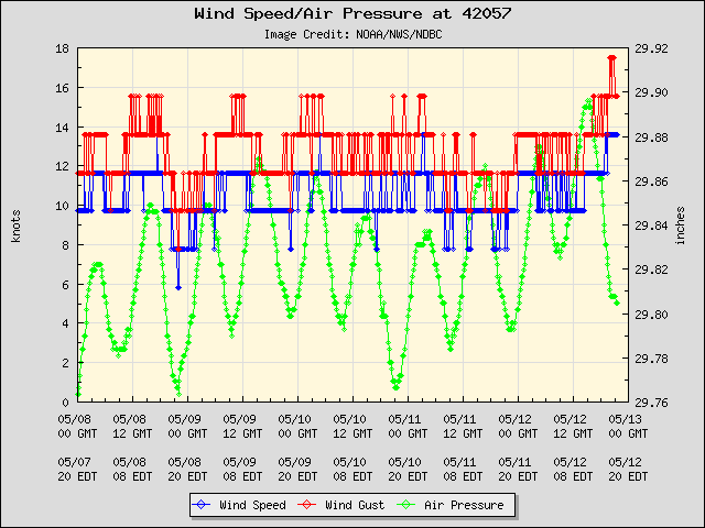
http://www.ndbc.noaa.gov/station_page.php?station=42057
But I don't think I would say wind shear is ideal for formation.

http://www.ndbc.noaa.gov/station_page.php?station=42057
But I don't think I would say wind shear is ideal for formation.
0 likes
M a r k
- - - - -
Join us in chat: Storm2K Chatroom Invite. Android and IOS apps also available.
The posts in this forum are NOT official forecasts and should not be used as such. Posts are NOT endorsed by any professional institution or STORM2K.org. For official information and forecasts, please refer to NHC and NWS products.
- - - - -
Join us in chat: Storm2K Chatroom Invite. Android and IOS apps also available.
The posts in this forum are NOT official forecasts and should not be used as such. Posts are NOT endorsed by any professional institution or STORM2K.org. For official information and forecasts, please refer to NHC and NWS products.
-
tolakram
- Admin
- Posts: 20186
- Age: 62
- Joined: Sun Aug 27, 2006 8:23 pm
- Location: Florence, KY (name is Mark)
Re: ATL: INVEST 93L - DISCUSSION
tolakram wrote:Either this is just a vortex or an LLC is forming, in my opinion. here's a better link to the loop.
http://wwwghcc.msfc.nasa.gov/cgi-bin/ge ... mframes=18
Speed it up to better see the formation of ... something.
Quoting myself here ... also note the satellite capture is in relatively high speed mode, every 10 minutes. Makes for a nice smooth loop. To me the circulation is quite clear.

0 likes
M a r k
- - - - -
Join us in chat: Storm2K Chatroom Invite. Android and IOS apps also available.
The posts in this forum are NOT official forecasts and should not be used as such. Posts are NOT endorsed by any professional institution or STORM2K.org. For official information and forecasts, please refer to NHC and NWS products.
- - - - -
Join us in chat: Storm2K Chatroom Invite. Android and IOS apps also available.
The posts in this forum are NOT official forecasts and should not be used as such. Posts are NOT endorsed by any professional institution or STORM2K.org. For official information and forecasts, please refer to NHC and NWS products.
-
Ivanhater
- Storm2k Moderator
- Posts: 11221
- Age: 39
- Joined: Fri Jul 01, 2005 8:25 am
- Location: Pensacola
Re: ATL: INVEST 93L - DISCUSSION
That would make sense Mark, that is where the models want to start developing this. Maybe when it slows and sets up in the western caribbean it will develop. Most of the convective activity has been east of the lowest pressure and maybe it will finally catch up with the LLC Friday and cook up.
0 likes
Michael
Yeah there is at least an attempt at something at lower levels trying to form there, though there has been broad circulation there for a while, it really needs to get a big convective burst over that rather than to the east.
Also shear does look a little higher than I thought it'd be...the GFS thus far has done a good job not calling for development, but then again most models don't do anything till W.Caribbean.
Also shear does look a little higher than I thought it'd be...the GFS thus far has done a good job not calling for development, but then again most models don't do anything till W.Caribbean.
0 likes
Personal Forecast Disclaimer:
The posts in this forum are NOT official forecast and should not be used as such. They are just the opinion of the poster and may or may not be backed by sound meteorological data. They are NOT endorsed by any professional institution or storm2k.org. For official information, please refer to the NHC and NWS products
The posts in this forum are NOT official forecast and should not be used as such. They are just the opinion of the poster and may or may not be backed by sound meteorological data. They are NOT endorsed by any professional institution or storm2k.org. For official information, please refer to the NHC and NWS products
Re: ATL: INVEST 93L - DISCUSSION
Pressure trumps appearance. Maybe if it heads north it will organize.
If I were to judge by eye alone I would say a hostile environment wore the Low down and it won't develop.
If I were to judge by eye alone I would say a hostile environment wore the Low down and it won't develop.
0 likes
-
Weatherfreak000
Re: ATL: INVEST 93L - DISCUSSION
Sanibel wrote:Pressure trumps appearance. Maybe if it heads north it will organize.
If I were to judge by eye alone I would say a hostile environment wore the Low down and it won't develop.
Yeah but remember this is heading into a region that is well known for June systems, and the W.Gom/BoC tends to be very favourable region for development at this time of year. I think this has a decent chance still.
0 likes
Personal Forecast Disclaimer:
The posts in this forum are NOT official forecast and should not be used as such. They are just the opinion of the poster and may or may not be backed by sound meteorological data. They are NOT endorsed by any professional institution or storm2k.org. For official information, please refer to the NHC and NWS products
The posts in this forum are NOT official forecast and should not be used as such. They are just the opinion of the poster and may or may not be backed by sound meteorological data. They are NOT endorsed by any professional institution or storm2k.org. For official information, please refer to the NHC and NWS products

Who is online
Users browsing this forum: No registered users and 34 guests