
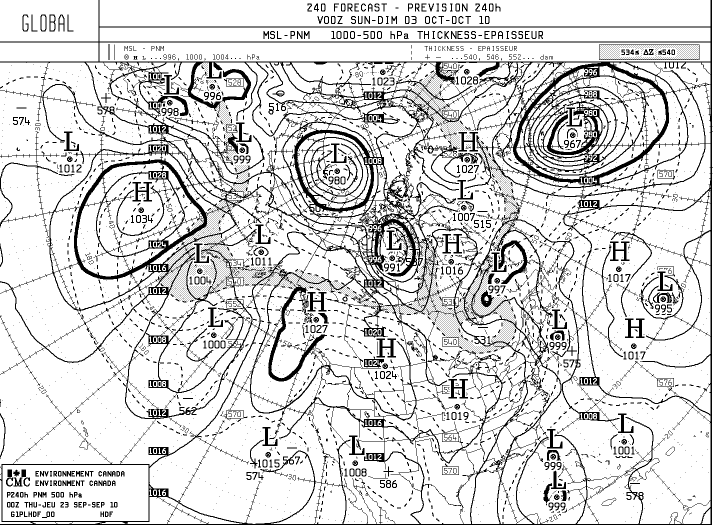
0z CMC...cut off low shoots NE ala NOGAPS...but like strings out 95L to just a huge area of low pressure....weird..
http://moe.met.fsu.edu/cgi-bin/cmctc2.c ... =Animation
ATL: MATTHEW - Models
Moderator: S2k Moderators
Re: ATL: INVEST 95L - Models
0 likes
-
Wx_Warrior
- Category 5

- Posts: 2718
- Joined: Thu Aug 03, 2006 3:58 pm
- Location: Beaumont, TX
-
vbhoutex

- Storm2k Executive

- Posts: 29149
- Age: 74
- Joined: Wed Oct 09, 2002 11:31 pm
- Location: Cypress, TX
- Contact:
Re: ATL: INVEST 95L - Models
ROCK wrote:0z CMC...cut off low shoots NE ala NOGAPS...but like strings out 95L to just a huge area of low pressure....weird..
http://moe.met.fsu.edu/cgi-bin/cmctc2.c ... =Animation
Maybe not so weird if you think about 95L/?? getting to the Yucatan and losing most of its' core just before/as the trough picks it up. The front is depicted to make it all the way to the Yucatan and I honestly am not sure it will, but if we go with that scenario it isn't quite as weird as it seems.
0 likes
Skywarn, C.E.R.T.
Please click below to donate to STORM2K to help with the expenses of keeping the site going:

Please click below to donate to STORM2K to help with the expenses of keeping the site going:

Re: ATL: INVEST 95L - Models
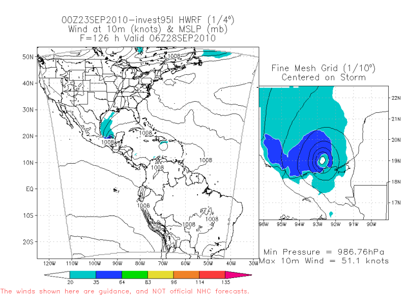
Damn.. the GFDL blows this up into a major hurricane 937mb 134kts.

0 likes
-
HurricaneRobert
- Category 3

- Posts: 812
- Joined: Fri May 18, 2007 9:31 pm
-
FLpanhandle91

- Category 5
- Posts: 1039
- Age: 34
- Joined: Mon Sep 13, 2010 3:50 pm
- Location: Fort Walton Beach, FL
Re: ATL: INVEST 95L - Models
HurricaneRobert wrote:That is a very Wilma-esque run.
god forbid..
0 likes
-
HurricaneRobert
- Category 3
- Posts: 812
- Joined: Fri May 18, 2007 9:31 pm
Re: ATL: INVEST 95L - Models
FLpanhandle91 wrote:
god forbid..
It does remind you of her in the early stages, though.

We'll see. I think it is a bit early for a Caribbean buster.
0 likes
-
Wx_Warrior
- Category 5
- Posts: 2718
- Joined: Thu Aug 03, 2006 3:58 pm
- Location: Beaumont, TX

-
Wx_Warrior
- Category 5
- Posts: 2718
- Joined: Thu Aug 03, 2006 3:58 pm
- Location: Beaumont, TX
-
Wx_Warrior
- Category 5
- Posts: 2718
- Joined: Thu Aug 03, 2006 3:58 pm
- Location: Beaumont, TX

This upper cutoff low is causing some serious model uncertainties, some of the models just shear this one totally out but slightly alter the timing and you've got a Wilma type system running into Florida.
Honestly this is going to be a tough call, this thread has a long way to run yet!
If it does stay offshore near the Yucatan I see no reason why this won't strengthen decently into a strong system...but this is a complex set-up and there could quite easily be some shear from the cutoff low yet, we'll have to see!
0 likes
Personal Forecast Disclaimer:
The posts in this forum are NOT official forecast and should not be used as such. They are just the opinion of the poster and may or may not be backed by sound meteorological data. They are NOT endorsed by any professional institution or storm2k.org. For official information, please refer to the NHC and NWS products
The posts in this forum are NOT official forecast and should not be used as such. They are just the opinion of the poster and may or may not be backed by sound meteorological data. They are NOT endorsed by any professional institution or storm2k.org. For official information, please refer to the NHC and NWS products
06z GFS doesn't really do much out to 96hrs, takes the system just to the north of Honduras and sits there for a while as well...
If it is a TC its probably a close call as to whether its far enough away from land to really strengthen much, but either way flooding rains would be an issue.
If it is a TC its probably a close call as to whether its far enough away from land to really strengthen much, but either way flooding rains would be an issue.
0 likes
Personal Forecast Disclaimer:
The posts in this forum are NOT official forecast and should not be used as such. They are just the opinion of the poster and may or may not be backed by sound meteorological data. They are NOT endorsed by any professional institution or storm2k.org. For official information, please refer to the NHC and NWS products
The posts in this forum are NOT official forecast and should not be used as such. They are just the opinion of the poster and may or may not be backed by sound meteorological data. They are NOT endorsed by any professional institution or storm2k.org. For official information, please refer to the NHC and NWS products
System moves near due east between 120-144hrs and strengthens, seems a slightly odd solution but both the ECM and GFS are suggesting that will be the case...we will see!
0 likes
Personal Forecast Disclaimer:
The posts in this forum are NOT official forecast and should not be used as such. They are just the opinion of the poster and may or may not be backed by sound meteorological data. They are NOT endorsed by any professional institution or storm2k.org. For official information, please refer to the NHC and NWS products
The posts in this forum are NOT official forecast and should not be used as such. They are just the opinion of the poster and may or may not be backed by sound meteorological data. They are NOT endorsed by any professional institution or storm2k.org. For official information, please refer to the NHC and NWS products
168hrs sees a strengthening system swinging back WNW, quite an interesting solution, down to 997mbs just south of Cuba:
http://raleighwx.easternuswx.com/models ... cal168.gif
http://raleighwx.easternuswx.com/models ... cal168.gif
0 likes
Personal Forecast Disclaimer:
The posts in this forum are NOT official forecast and should not be used as such. They are just the opinion of the poster and may or may not be backed by sound meteorological data. They are NOT endorsed by any professional institution or storm2k.org. For official information, please refer to the NHC and NWS products
The posts in this forum are NOT official forecast and should not be used as such. They are just the opinion of the poster and may or may not be backed by sound meteorological data. They are NOT endorsed by any professional institution or storm2k.org. For official information, please refer to the NHC and NWS products
06z GFS seems a little bit slower then the 00z GFS with the forward motion but seems to be quicker with exiting the cutoff low and takes the system on a path probably very similar to Irene once past Cuba...just a smidge further north and across S.Florida.
Would give a good chunk of the state some decent winds though thats for sure!
ps, then the system really races to the north into N.GA by 228hrs and starts to go extratropical inland by 240hrs.
Would give a good chunk of the state some decent winds though thats for sure!
ps, then the system really races to the north into N.GA by 228hrs and starts to go extratropical inland by 240hrs.
Last edited by KWT on Thu Sep 23, 2010 5:46 am, edited 1 time in total.
0 likes
Personal Forecast Disclaimer:
The posts in this forum are NOT official forecast and should not be used as such. They are just the opinion of the poster and may or may not be backed by sound meteorological data. They are NOT endorsed by any professional institution or storm2k.org. For official information, please refer to the NHC and NWS products
The posts in this forum are NOT official forecast and should not be used as such. They are just the opinion of the poster and may or may not be backed by sound meteorological data. They are NOT endorsed by any professional institution or storm2k.org. For official information, please refer to the NHC and NWS products


-
HURAKAN

- Professional-Met

- Posts: 46084
- Age: 39
- Joined: Thu May 20, 2004 4:34 pm
- Location: Key West, FL
- Contact:
Re: ATL: INVEST 95L - Models
Code: Select all
808
WHXX01 KWBC 230847
CHGHUR
TROPICAL CYCLONE GUIDANCE MESSAGE
NWS TPC/NATIONAL HURRICANE CENTER MIAMI FL
0847 UTC THU SEP 23 2010

DISCLAIMER...NUMERICAL MODELS ARE SUBJECT TO LARGE ERRORS.
PLEASE REFER TO NHC OFFICIAL FORECASTS FOR TROPICAL CYCLONE
AND SUBTROPICAL CYCLONE INFORMATION.

ATLANTIC OBJECTIVE AIDS FOR

DISTURBANCE INVEST (AL952010) 20100923 0600 UTC

        ...00 HRS...   ...12 HRS...   ...24 HRS. ..   ...36 HRS...
        100923  0600   100923  1800   100924  0600   100924  1800

         LAT    LON     LAT    LON     LAT    LON     LAT    LON
BAMS    13.0N  73.1W   13.7N  75.5W   14.3N  77.8W   15.0N  80.4W
BAMD    13.0N  73.1W   13.1N  75.5W   13.2N  78.0W   13.4N  80.4W
BAMM    13.0N  73.1W   13.4N  75.3W   13.8N  77.7W   14.3N  80.1W
LBAR    13.0N  73.1W   13.4N  75.7W   14.0N  78.8W   14.6N  81.9W
SHIP        30KTS          37KTS          47KTS          60KTS
DSHP        30KTS          37KTS          47KTS          60KTS

        ...48 HRS...   ...72 HRS...   ...96 HRS. ..   ..120 HRS...
        100925  0600   100926  0600   100927  0600   100928  0600

         LAT    LON     LAT    LON     LAT    LON     LAT    LON
BAMS    15.6N  82.8W   16.9N  87.5W   17.7N  90.4W   16.7N  91.3W
BAMD    13.8N  82.7W   15.1N  86.2W   16.6N  87.9W   16.9N  88.5W
BAMM    14.9N  82.5W   16.4N  86.7W   17.7N  89.4W   17.0N  90.6W
LBAR    15.3N  84.8W   17.6N  89.9W   20.1N  92.8W   22.0N  92.5W
SHIP        73KTS          96KTS         109KTS         113KTS
DSHP        73KTS          67KTS          41KTS          28KTS

         ...INITIAL CONDITIONS...
LATCUR =  13.0N LONCUR =  73.1W DIRCUR = 280DEG SPDCUR =  13KT
LATM12 =  12.6N LONM12 =  70.5W DIRM12 = 277DEG SPDM12 =  12KT
LATM24 =  12.5N LONM24 =  67.5W
WNDCUR =   30KT RMAXWD =   60NM WNDM12 =   25KT
CENPRS = 1007MB OUTPRS = 1010MB OUTRAD =  130NM SDEPTH =   S
RD34NE =    0NM RD34SE =    0NM RD34SW =    0NM RD34NW =   0NM

$$
NNNN
0 likes
Cheers for that ronjon, it seems like the ensembles are slower at lifting this system out though the actual position is very close to what the GFS has been expecting for 180-192hrs, so just a little slower in the end.
0 likes
Personal Forecast Disclaimer:
The posts in this forum are NOT official forecast and should not be used as such. They are just the opinion of the poster and may or may not be backed by sound meteorological data. They are NOT endorsed by any professional institution or storm2k.org. For official information, please refer to the NHC and NWS products
The posts in this forum are NOT official forecast and should not be used as such. They are just the opinion of the poster and may or may not be backed by sound meteorological data. They are NOT endorsed by any professional institution or storm2k.org. For official information, please refer to the NHC and NWS products
-
SouthFLTropics

- Category 5
- Posts: 4258
- Age: 50
- Joined: Thu Aug 14, 2003 8:04 am
- Location: Port St. Lucie, Florida
Run after run we are consistantly seeing a threat to a good portion of Florida by some of the more reliable models. I think it is fair to start assuming that we are going to see some impacts from this system. The question is how much, how strong?
SFT
SFT
0 likes
Fourth Generation Florida Native
Personal Storm History: David 79, Andrew 92, Erin 95, Floyd 99, Irene 99, Frances 04, Jeanne 04, Wilma 05, Matthew 16, Irma 17, Ian 22, Nicole 22, Milton 24
Personal Storm History: David 79, Andrew 92, Erin 95, Floyd 99, Irene 99, Frances 04, Jeanne 04, Wilma 05, Matthew 16, Irma 17, Ian 22, Nicole 22, Milton 24
Hurakan, good agreement now at least for the first 72hrs of a track just to the north of Honduras...
There is some models though trying to take this into the BoC so will be interesting to watch if more models try and do the same thing...also seems to be an awful lot of uncertainty with what happens once the steering currents go slack.
Real tough call!
There is some models though trying to take this into the BoC so will be interesting to watch if more models try and do the same thing...also seems to be an awful lot of uncertainty with what happens once the steering currents go slack.
Real tough call!
0 likes
Personal Forecast Disclaimer:
The posts in this forum are NOT official forecast and should not be used as such. They are just the opinion of the poster and may or may not be backed by sound meteorological data. They are NOT endorsed by any professional institution or storm2k.org. For official information, please refer to the NHC and NWS products
The posts in this forum are NOT official forecast and should not be used as such. They are just the opinion of the poster and may or may not be backed by sound meteorological data. They are NOT endorsed by any professional institution or storm2k.org. For official information, please refer to the NHC and NWS products
Who is online
Users browsing this forum: No registered users and 35 guests