ATL : INVEST 90L
Moderator: S2k Moderators
-
wxman57

- Moderator-Pro Met

- Posts: 23175
- Age: 68
- Joined: Sat Jun 21, 2003 8:06 pm
- Location: Houston, TX (southwest)
Re: ATL : INVEST 90L
I don't think this low will amount to much. Will probably drift NW over the next 2-3 days but with some continued westerly shear, most effects should remain offshore. Probably won't get named.
0 likes


-
brunota2003

- S2K Supporter

- Posts: 9476
- Age: 35
- Joined: Sat Jul 30, 2005 9:56 pm
- Location: Stanton, KY...formerly Havelock, NC
- Contact:
-
dolebot_Broward_NW
- Category 2

- Posts: 529
- Joined: Fri Sep 10, 2004 6:38 am


Re: ATL : INVEST 90L
Looks good, but I hope it kicks out of the way ASAP, as it's helping squash any chance of rain for S FL...making the weather here quite boring.
0 likes


-
Pedro Fernández

- Tropical Storm

- Posts: 233
- Age: 48
- Joined: Mon Dec 31, 2007 7:24 am
- Location: Costa Tropical (Granada, Spain).
- Contact:

Not a bad little convective burst from 90L, I've few doubts the NHC are taking a close look at this system with convection slightly strengthening again....
0 likes
Personal Forecast Disclaimer:
The posts in this forum are NOT official forecast and should not be used as such. They are just the opinion of the poster and may or may not be backed by sound meteorological data. They are NOT endorsed by any professional institution or storm2k.org. For official information, please refer to the NHC and NWS products
The posts in this forum are NOT official forecast and should not be used as such. They are just the opinion of the poster and may or may not be backed by sound meteorological data. They are NOT endorsed by any professional institution or storm2k.org. For official information, please refer to the NHC and NWS products
-
JonathanBelles
- Professional-Met

- Posts: 11430
- Age: 35
- Joined: Sat Dec 24, 2005 9:00 pm
- Location: School: Florida State University (Tallahassee, FL) Home: St. Petersburg, Florida
- Contact:
Re:
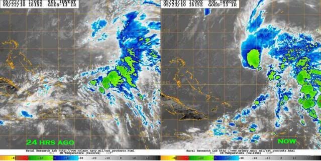
Pedro Fernández wrote:Wind shear has dropped to only 10 KT over the system (CIMSS), while it was aorund 30-40 in the map before...
Deep convection is closer and closer of the LLCC.
I was waiting for someone to comment on that. This low seems to be making its own shear drought. The area around the low has the lowest shear in the Atlantic, and shear continues to fall. I'm quite confused by it over all. Even with the lower shear, the vertical column from the LLC to MLC is very tilted from SW to NE.
0 likes

Re: ATL : INVEST 90L
It reminds me to the early extratropical stage of 2007 subtropical storm Andrea with plenty of dry air to its west and plenty of moisture to its east and there are no analyzed fronts attached to it, so I still think it has a chance to develop although conditions need to improve a little more and I'm not sure that it will happen.
0 likes
-
Pedro Fernández
- Tropical Storm
- Posts: 233
- Age: 48
- Joined: Mon Dec 31, 2007 7:24 am
- Location: Costa Tropical (Granada, Spain).
- Contact:
Re: Re:
fact789 wrote:Pedro Fernández wrote:Wind shear has dropped to only 10 KT over the system (CIMSS), while it was aorund 30-40 in the map before...
Deep convection is closer and closer of the LLCC.
I was waiting for someone to comment on that. This low seems to be making its own shear drought. The area around the low has the lowest shear in the Atlantic, and shear continues to fall. I'm quite confused by it over all. Even with the lower shear, the vertical column from the LLC to MLC is very tilted from SW to NE.
Hmmm... Perhaps the low needs a few time to feel the lower shear in its structure... I'm sure if this low shear persists, we could see a tropical transition. If there is enough time to make it.
0 likes
Re: Re:
fact789 wrote: Even with the lower shear, the vertical column from the LLC to MLC is very tilted from SW to NE.
It doesn't seem to be very well stacked at all and IMO still has a classic shear signature, the shear does seem to have decreased compared with yesterday but its still at the top end of what you'd like it to be to get some sort of development.
0 likes
Personal Forecast Disclaimer:
The posts in this forum are NOT official forecast and should not be used as such. They are just the opinion of the poster and may or may not be backed by sound meteorological data. They are NOT endorsed by any professional institution or storm2k.org. For official information, please refer to the NHC and NWS products
The posts in this forum are NOT official forecast and should not be used as such. They are just the opinion of the poster and may or may not be backed by sound meteorological data. They are NOT endorsed by any professional institution or storm2k.org. For official information, please refer to the NHC and NWS products
-
cycloneye

- Admin

- Posts: 149585
- Age: 69
- Joined: Thu Oct 10, 2002 10:54 am
- Location: San Juan, Puerto Rico
Re: ATL : INVEST 90L
From 2:05 PM EDT discussion:
SPECIAL FEATURES...
A SURFACE TROUGH EXTENDS FROM 27N69W THROUGH A WEAKENING 1008 MB
LOW NEAR 25N70W TO THE TURKS AND CAICOS NEAR 22N72W. SATELLITE
SUGGESTS THAT A SECOND LOW IS DEVELOPING TO THE NORTH OF THE
CURRENT LOW AND WILL BE ADDED AT 23/1800 UTC. SCATTERED SHOWERS/
ISOLATED THUNDERSTORMS ARE N AND E OF THE LOW WITHIN 120/150 NM
OF LINE FROM 22N58W TO 29N69W AND ISOLATED/SCATTERED SHOWERS
WITH ISOLATED THUNDERSTORMS WITHIN 60/75 NM OF LINE FROM 21N67W
TO 23N65W. GALE FORCE WINDS ARE FOUND FROM 27N-29N BETWEEN
64W-70W. THIS SYSTEM IS EXPECTED TO MOVE N AND BE N OF THE
REGION BY LATE TUE NIGHT THEN WILL DRIFT E THROUGH THU.
0 likes
Visit the Caribbean-Central America Weather Thread where you can find at first post web cams,radars
and observations from Caribbean basin members Click Here
and observations from Caribbean basin members Click Here
-
Hurricanehink

- S2K Supporter
- Posts: 2046
- Joined: Sun Nov 16, 2003 2:05 pm
- Location: New Jersey
-
djones65
- Category 1

- Posts: 264
- Age: 60
- Joined: Mon Jun 20, 2005 12:05 am
- Location: Ocean Springs, MS
The reason the shear values are "down" is because the upper level circulation is more closely co-located with the low level circulation. In other words, as the upper level cyclone tries to become stacked over the low level circulation the shear values will be low, but it is still within a large trough and very cold temps aloft. If the upper level and low level circulations can become aligned a transition could occur with time. I personally think the system will eventually become aligned and could become a subtropical storm by Monday night or Tuesday, but shear values are useless with this system and should be disregarded. This is not a situation in which the circulation is strengthening from the surface upward (where shear would be critical for it). Satellite imagery over the past 24 hours clearly show that the upper level and low level circulations are becoming more closely aligned. If this continues I believe we'll see a gradual transition to subtropical.
0 likes
Who is online
Users browsing this forum: No registered users and 56 guests