ATL: INVEST 94L - DISCUSSION

Moderator: S2k Moderators

Message
Author
User avatar
Gustywind
Category 5
Category 5
Posts: 12334
Joined: Mon Sep 03, 2007 7:29 am
Location: Baie-Mahault, GUADELOUPE

#81 Postby Gustywind » Sat Jun 26, 2010 6:11 pm

Latest weather forecast of Meteo-France Guadeloupe concerning 94L:
For info we're always in yellow alert for a risk of strong showers/tstorms.
:rarrow: http://www.meteo.fr/temps/domtom/antill ... ivi_gd.pdf (french version for those who want to improve theirc french :), weheras i have translated much of this text in text to highlight the info)
Synopsis:

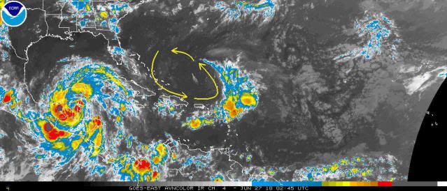
An important perturbed area crosses the nothern part of the Lesser Antilles, bringing locally strong cells of tstorms between Dominica and St Marteen. Strong showers have already reached la Désirade (more than 60mm) and Le
Moule (40 mm) this morning , then the northern tip of the island (Nord Basse-Terre) from Petit-
Bourg (more than 100 mm ) at Saint-Rose (near 60 mm) this afternoon.

Forecasts:This tstorm activity should continue tonight and tommorow morning. Tstorms developps locally and could bring strong amounts of water locally. An improvement of the weather is expected tommorow afternoon.

Commentary/Consequences:
No orange alert is expected. Be prudent and vigilant!

Summary:
The impact expected is moderate.

Validity/Duration of this feature:
Until tommrow morning 27th of June.
Next weather forecast tommorow 6AM.
0 likes   

User avatar
Gustywind
Category 5
Category 5
Posts: 12334
Joined: Mon Sep 03, 2007 7:29 am
Location: Baie-Mahault, GUADELOUPE

#82 Postby Gustywind » Sat Jun 26, 2010 6:12 pm

Lightnings are making the show right now with the rain, more and more since 5 minutes :eek:
0 likes   

User avatar
Gustywind
Category 5
Category 5
Posts: 12334
Joined: Mon Sep 03, 2007 7:29 am
Location: Baie-Mahault, GUADELOUPE

#83 Postby Gustywind » Sat Jun 26, 2010 6:21 pm

It's boombing i have to shut down my computer, lightnings amplifies thunder is rubling very strongly. Tstorms are very close to the house now i'm living now, too much :eek:
0 likes   

User avatar
cycloneye
Admin
Admin
Posts: 139758
Age: 67
Joined: Thu Oct 10, 2002 10:54 am
Location: San Juan, Puerto Rico

Re:

#84 Postby cycloneye » Sat Jun 26, 2010 6:24 pm

Gustywind wrote:It's boombing i have to shut down my computer, lightnings amplifies thunder is rubling very strongly. Tstorms are very close to the house now i'm living now, too much :eek:


Be careful there and stay safe.
0 likes   
Visit the Caribbean-Central America Weather Thread where you can find at first post web cams,radars
and observations from Caribbean basin members Click Here

User avatar
KWT
Category 5
Category 5
Posts: 31391
Joined: Tue Aug 17, 2004 11:02 am
Location: UK!!!

#85 Postby KWT » Sat Jun 26, 2010 6:27 pm

Yeah looks like there is still plenty of acitivity with this whole region that is being amplified by the shear from the jet streak.
0 likes   
Personal Forecast Disclaimer:
The posts in this forum are NOT official forecast and should not be used as such. They are just the opinion of the poster and may or may not be backed by sound meteorological data. They are NOT endorsed by any professional institution or storm2k.org. For official information, please refer to the NHC and NWS products

User avatar
HURAKAN
Professional-Met
Professional-Met
Posts: 46086
Age: 37
Joined: Thu May 20, 2004 4:34 pm
Location: Key West, FL
Contact:

#86 Postby HURAKAN » Sat Jun 26, 2010 6:36 pm

805
ABNT20 KNHC 262333
TWOAT
TROPICAL WEATHER OUTLOOK
NWS TPC/NATIONAL HURRICANE CENTER MIAMI FL
800 PM EDT SAT JUN 26 2010

FOR THE NORTH ATLANTIC...CARIBBEAN SEA AND THE GULF OF MEXICO...

THE NATIONAL HURRICANE CENTER IS ISSUING ADVISORIES ON TROPICAL
STORM ALEX...LOCATED 15 MILES SOUTHEAST OF BELIZE CITY.

DISORGANIZED CLOUDINESS AND SHOWERS EXTENDING FROM THE NORTHERN
LEEWARD ISLANDS NORTHEASTWARD INTO THE ATLANTIC FOR SEVERAL HUNDRED
MILES ARE ASSOCIATED WITH A TROPICAL WAVE INTERACTING WITH AN
UPPER-LEVEL TROUGH. CONDITIONS ARE EXPECTED TO REMAIN UNFAVORABLE
FOR TROPICAL CYCLONE FORMATION AS THIS SYSTEM MOVES TOWARD THE
NORTH-NORTHWEST AT 10 TO 15 MPH. THERE IS A LOW CHANCE...NEAR 0
PERCENT...OF THIS SYSTEM BECOMING A TROPICAL CYCLONE DURING THE
NEXT 48 HOURS.


ELSEWHERE...TROPICAL CYCLONE FORMATION IS NOT EXPECTED DURING THE
NEXT 48 HOURS.

$$
FORECASTER BRENNAN
Last edited by HURAKAN on Sat Jun 26, 2010 6:44 pm, edited 1 time in total.
0 likes   

User avatar
KWT
Category 5
Category 5
Posts: 31391
Joined: Tue Aug 17, 2004 11:02 am
Location: UK!!!

#87 Postby KWT » Sat Jun 26, 2010 6:42 pm

Looks like 94L is just about done according to the NHC, I think most of the attention will be on Alex for the next few days anyway...
0 likes   
Personal Forecast Disclaimer:
The posts in this forum are NOT official forecast and should not be used as such. They are just the opinion of the poster and may or may not be backed by sound meteorological data. They are NOT endorsed by any professional institution or storm2k.org. For official information, please refer to the NHC and NWS products

User avatar
HURAKAN
Professional-Met
Professional-Met
Posts: 46086
Age: 37
Joined: Thu May 20, 2004 4:34 pm
Location: Key West, FL
Contact:

Re:

#88 Postby HURAKAN » Sat Jun 26, 2010 6:45 pm

KWT wrote:Looks like 94L is just about done according to the NHC, I think most of the attention will be on Alex for the next few days anyway...


Nothing can be expected until much later on. If 94L continues to interact with the ULL, no development can be expected.
0 likes   

User avatar
msbee
S2K Supporter
S2K Supporter
Posts: 3010
Joined: Wed Jun 11, 2003 10:11 am
Location: St. Maarten

Re:

#89 Postby msbee » Sat Jun 26, 2010 7:16 pm

Gustywind wrote:It's boombing i have to shut down my computer, lightnings amplifies thunder is rubling very strongly. Tstorms are very close to the house now i'm living now, too much :eek:


Gusty
stay safe
hope everything is OK there.
0 likes   
Too many hurricanes to remember

User avatar
Gustywind
Category 5
Category 5
Posts: 12334
Joined: Mon Sep 03, 2007 7:29 am
Location: Baie-Mahault, GUADELOUPE

Re: Re:

#90 Postby Gustywind » Sat Jun 26, 2010 8:07 pm

msbee wrote:
Gustywind wrote:It's boombing i have to shut down my computer, lightnings amplifies thunder is rubling very strongly. Tstorms are very close to the house now i'm living now, too much :eek:


Gusty
stay safe
hope everything is OK there.

Thanks Cycloneye, Msbee and the others for these thoughts, i appreciate sincerely :) Oh boy what a mess with these tstorms!!! :eek: This perturbed area is much more electric than the previous last week for sure :eek:!
They were enough strong sometimes, lightnings were making the show and i have wrote my last lost! We experienced a brief poweroutages during 5 secondes but hopefully all is ok, no problem i'm ok. Rain has stopped as the lightnings, thunder is rumbling less lourder, so good news for us :). After that i advice you my friend in the others islands to be very prudent, 94L is not organized but does not give up even to moving away so be carefull!
0 likes   

User avatar
Gustywind
Category 5
Category 5
Posts: 12334
Joined: Mon Sep 03, 2007 7:29 am
Location: Baie-Mahault, GUADELOUPE

Re: Re:

#91 Postby Gustywind » Sat Jun 26, 2010 8:09 pm

cycloneye wrote:
Gustywind wrote:It's boombing i have to shut down my computer, lightnings amplifies thunder is rubling very strongly. Tstorms are very close to the house now i'm living now, too much :eek:


Be careful there and stay safe.

Thanks Luis :) i'm ok.
0 likes   

Weatherfreak000

#92 Postby Weatherfreak000 » Sat Jun 26, 2010 8:35 pm

94L still flaring up. Still some potential I believe.
0 likes   

ozonepete
Professional-Met
Professional-Met
Posts: 4743
Joined: Mon Sep 07, 2009 3:23 pm
Location: From Ozone Park, NYC / Now in Brooklyn, NY

Re: ATL: INVEST 94L - DISCUSSION

#93 Postby ozonepete » Sat Jun 26, 2010 10:49 pm

The TUTT that has been interacting with 94L has gradually eased up and is gone now. Over the past few days it has degenerated from a very large positively tilted upper level trough to a negatively tilted one that has naturally evolved into an upper level low. That ULL is now contracting and moving westward. This could very well finally allow the very persistent wave that was 94L to start intensifying. Persistence is always significant in tropical cyclone development. Worth watching.

Image
0 likes   

User avatar
HURAKAN
Professional-Met
Professional-Met
Posts: 46086
Age: 37
Joined: Thu May 20, 2004 4:34 pm
Location: Key West, FL
Contact:

#94 Postby HURAKAN » Sat Jun 26, 2010 11:40 pm

ARLENE, 1999:

"A mid/upper level low emerged from a diffused front on June 8. This low was located several hundred miles north of Puerto Rico. Around this time, a tropical wave passed near the low. Over the next two days, the low level cloud swirl did not significantly develop, as wind shear was present. Convection began to gather near the center as wind shear was decreasing because of an upper level low moving away. It was estimated that by June 11 the low had strengthened into a tropical depression, therefore becoming Tropical Depression One, while it was centered about 345 miles (555 km) from Bermuda."

Link - http://en.wikipedia.org/wiki/Tropical_S ... %281999%29

Image
0 likes   

User avatar
HURAKAN
Professional-Met
Professional-Met
Posts: 46086
Age: 37
Joined: Thu May 20, 2004 4:34 pm
Location: Key West, FL
Contact:

#95 Postby HURAKAN » Sat Jun 26, 2010 11:47 pm

Image

Vorticity is increasing
0 likes   

User avatar
HURAKAN
Professional-Met
Professional-Met
Posts: 46086
Age: 37
Joined: Thu May 20, 2004 4:34 pm
Location: Key West, FL
Contact:

#96 Postby HURAKAN » Sat Jun 26, 2010 11:48 pm

AL, 94, 2010062700, , BEST, 0, 173N, 604W, 25, 1013, DB

It's alive!!!
0 likes   

ozonepete
Professional-Met
Professional-Met
Posts: 4743
Joined: Mon Sep 07, 2009 3:23 pm
Location: From Ozone Park, NYC / Now in Brooklyn, NY

Re: ATL: INVEST 94L - DISCUSSION

#97 Postby ozonepete » Sun Jun 27, 2010 2:07 am

Something's gotta give with this system. The lower level wave action is pushing up really hard to the west due to the trade winds. It all hinges on what that receding ULL does. If the ULL weakens, this has a good chance of developing.
0 likes   

User avatar
Gustywind
Category 5
Category 5
Posts: 12334
Joined: Mon Sep 03, 2007 7:29 am
Location: Baie-Mahault, GUADELOUPE

#98 Postby Gustywind » Sun Jun 27, 2010 4:48 am

Code Yellow
Image
000
ABNT20 KNHC 270600
TWOAT
TROPICAL WEATHER OUTLOOK
NWS TPC/NATIONAL HURRICANE CENTER MIAMI FL
200 AM EDT SUN JUN 27 2010

FOR THE NORTH ATLANTIC...CARIBBEAN SEA AND THE GULF OF MEXICO...

THE NATIONAL HURRICANE CENTER IS ISSUING ADVISORIES ON TROPICAL
STORM ALEX...LOCATED OVER THE SOUTHERN YUCATAN PENINSULA ABOUT 165
MILES SOUTHEAST OF CAMPECHE MEXICO.

DISORGANIZED CLOUDINESS AND SHOWERS EXTENDING FROM THE NORTHERN
LEEWARD ISLANDS NORTHEASTWARD INTO THE ATLANTIC FOR SEVERAL HUNDRED
MILES ARE ASSOCIATED WITH A TROPICAL WAVE INTERACTING WITH AN
UPPER-LEVEL TROUGH. CONDITIONS ARE EXPECTED TO REMAIN UNFAVORABLE
FOR TROPICAL CYCLONE FORMATION AS THIS SYSTEM MOVES TOWARD THE
NORTHWEST AT 5 TO 10 MPH. THERE IS A LOW CHANCE...NEAR 0
PERCENT...OF THIS SYSTEM BECOMING A TROPICAL CYCLONE DURING THE
NEXT 48 HOURS.


ELSEWHERE...TROPICAL CYCLONE FORMATION IS NOT EXPECTED DURING THE
NEXT 48 HOURS.

$$
FORECASTER STEWART
0 likes   

User avatar
Gustywind
Category 5
Category 5
Posts: 12334
Joined: Mon Sep 03, 2007 7:29 am
Location: Baie-Mahault, GUADELOUPE

#99 Postby Gustywind » Sun Jun 27, 2010 4:51 am

Image
Image
0 likes   

User avatar
KWT
Category 5
Category 5
Posts: 31391
Joined: Tue Aug 17, 2004 11:02 am
Location: UK!!!

#100 Postby KWT » Sun Jun 27, 2010 5:05 am

Well if nothing else this system is enhancing storm activity in the NE Caribbean with some cells having developed overnight.

Still at near 0% chance though!
0 likes   
Personal Forecast Disclaimer:
The posts in this forum are NOT official forecast and should not be used as such. They are just the opinion of the poster and may or may not be backed by sound meteorological data. They are NOT endorsed by any professional institution or storm2k.org. For official information, please refer to the NHC and NWS products


Return to “2010”

Who is online

Users browsing this forum: No registered users and 6 guests