ATL : INVEST 90L - COMPUTER MODELS
Moderator: S2k Moderators
-
HURAKAN

- Professional-Met

- Posts: 46084
- Age: 39
- Joined: Thu May 20, 2004 4:34 pm
- Location: Key West, FL
- Contact:
000
WHXX01 KWBC 211221
CHGHUR
TROPICAL CYCLONE GUIDANCE MESSAGE
NWS TPC/NATIONAL HURRICANE CENTER MIAMI FL
1221 UTC FRI MAY 21 2010
DISCLAIMER...NUMERICAL MODELS ARE SUBJECT TO LARGE ERRORS.
PLEASE REFER TO NHC OFFICIAL FORECASTS FOR TROPICAL CYCLONE
AND SUBTROPICAL CYCLONE INFORMATION.
ATLANTIC OBJECTIVE AIDS FOR
DISTURBANCE INVEST (AL902010) 20100521 1200 UTC
...00 HRS... ...12 HRS... ...24 HRS. .. ...36 HRS...
100521 1200 100522 0000 100522 1200 100523 0000
LAT LON LAT LON LAT LON LAT LON
BAMS 27.5N 72.3W 27.5N 73.1W 27.4N 74.4W 27.1N 75.7W
BAMD 27.5N 72.3W 27.4N 69.8W 28.0N 68.7W 29.3N 68.7W
BAMM 27.5N 72.3W 27.3N 72.4W 27.2N 73.0W 27.2N 73.6W
LBAR 27.5N 72.3W 27.9N 71.3W 28.2N 70.7W 28.7N 70.1W
SHIP 25KTS 26KTS 26KTS 24KTS
DSHP 25KTS 26KTS 26KTS 24KTS
...48 HRS... ...72 HRS... ...96 HRS. .. ..120 HRS...
100523 1200 100524 1200 100525 1200 100526 1200
LAT LON LAT LON LAT LON LAT LON
BAMS 26.6N 77.3W 25.4N 80.6W 24.6N 83.6W 24.5N 85.7W
BAMD 30.9N 69.1W 34.6N 70.0W 36.6N 74.4W 36.3N 79.7W
BAMM 26.8N 74.3W 25.4N 75.4W 25.5N 71.4W 31.0N 66.6W
LBAR 29.2N 69.7W 30.9N 68.7W 35.2N 66.9W 38.7N 65.6W
SHIP 19KTS 0KTS 0KTS 0KTS
DSHP 19KTS 0KTS 0KTS 0KTS
...INITIAL CONDITIONS...
LATCUR = 27.5N LONCUR = 72.3W DIRCUR = 300DEG SPDCUR = 2KT
LATM12 = 27.4N LONM12 = 71.7W DIRM12 = 326DEG SPDM12 = 2KT
LATM24 = 27.0N LONM24 = 71.8W
WNDCUR = 25KT RMAXWD = 40NM WNDM12 = 15KT
CENPRS = 1013MB OUTPRS = 1015MB OUTRAD = 80NM SDEPTH = S
RD34NE = 0NM RD34SE = 0NM RD34SW = 0NM RD34NW = 0NM
$$
NNNN

All over the place
WHXX01 KWBC 211221
CHGHUR
TROPICAL CYCLONE GUIDANCE MESSAGE
NWS TPC/NATIONAL HURRICANE CENTER MIAMI FL
1221 UTC FRI MAY 21 2010
DISCLAIMER...NUMERICAL MODELS ARE SUBJECT TO LARGE ERRORS.
PLEASE REFER TO NHC OFFICIAL FORECASTS FOR TROPICAL CYCLONE
AND SUBTROPICAL CYCLONE INFORMATION.
ATLANTIC OBJECTIVE AIDS FOR
DISTURBANCE INVEST (AL902010) 20100521 1200 UTC
...00 HRS... ...12 HRS... ...24 HRS. .. ...36 HRS...
100521 1200 100522 0000 100522 1200 100523 0000
LAT LON LAT LON LAT LON LAT LON
BAMS 27.5N 72.3W 27.5N 73.1W 27.4N 74.4W 27.1N 75.7W
BAMD 27.5N 72.3W 27.4N 69.8W 28.0N 68.7W 29.3N 68.7W
BAMM 27.5N 72.3W 27.3N 72.4W 27.2N 73.0W 27.2N 73.6W
LBAR 27.5N 72.3W 27.9N 71.3W 28.2N 70.7W 28.7N 70.1W
SHIP 25KTS 26KTS 26KTS 24KTS
DSHP 25KTS 26KTS 26KTS 24KTS
...48 HRS... ...72 HRS... ...96 HRS. .. ..120 HRS...
100523 1200 100524 1200 100525 1200 100526 1200
LAT LON LAT LON LAT LON LAT LON
BAMS 26.6N 77.3W 25.4N 80.6W 24.6N 83.6W 24.5N 85.7W
BAMD 30.9N 69.1W 34.6N 70.0W 36.6N 74.4W 36.3N 79.7W
BAMM 26.8N 74.3W 25.4N 75.4W 25.5N 71.4W 31.0N 66.6W
LBAR 29.2N 69.7W 30.9N 68.7W 35.2N 66.9W 38.7N 65.6W
SHIP 19KTS 0KTS 0KTS 0KTS
DSHP 19KTS 0KTS 0KTS 0KTS
...INITIAL CONDITIONS...
LATCUR = 27.5N LONCUR = 72.3W DIRCUR = 300DEG SPDCUR = 2KT
LATM12 = 27.4N LONM12 = 71.7W DIRM12 = 326DEG SPDM12 = 2KT
LATM24 = 27.0N LONM24 = 71.8W
WNDCUR = 25KT RMAXWD = 40NM WNDM12 = 15KT
CENPRS = 1013MB OUTPRS = 1015MB OUTRAD = 80NM SDEPTH = S
RD34NE = 0NM RD34SE = 0NM RD34SW = 0NM RD34NW = 0NM
$$
NNNN
All over the place
0 likes
-
AJC3

- Admin

- Posts: 4156
- Age: 62
- Joined: Tue Aug 31, 2004 7:04 pm
- Location: Ballston Spa, New York
- Contact:
Re:
HURAKAN wrote: All over the place
LOL...true. Fortunately, given the B/I nature of this system, this is a case where the hurricane track guidance can be crapcanned in favor of the global models. The ECM and GFS are in pretty good agreement with the track of this low, although the ECM continues to be several MB deeper with the intensity.
0 likes
-
Cookie

- S2K Supporter

- Posts: 477
- Age: 38
- Joined: Sun Dec 14, 2008 11:13 am
- Location: Isle Of lewis scotland
Re: Re:
AJC3 wrote:HURAKAN wrote: All over the place
LOL...true. Fortunately, given the B/I nature of this system, this is a case where the hurricane track guidance can be crapcanned in favor of the global models. The ECM and GFS are in pretty good agreement with the track of this low, although the ECM continues to be several MB deeper with the intensity.
B/I nature?
0 likes
-
cycloneye

- Admin
- Posts: 149584
- Age: 69
- Joined: Thu Oct 10, 2002 10:54 am
- Location: San Juan, Puerto Rico
Re: ATL : INVEST 90L - COMPUTER MODELS
Here is the SHIP first data about 90L.Shear is horrendous.
Code: Select all
   *   ATLANTIC SHIPS INTENSITY FORECAST       *
                    *      GOES DATA AVAILABLE                  *
                    *      OHC  DATA AVAILABLE                  *
                    *      INVEST  AL902010  05/21/10  12 UTC   *

TIME (HR)          0     6    12    18    24    36    48    60    72    84    96   108   120
V (KT) NO LAND    25    25    26    26    26    24    19   DIS   DIS   DIS   DIS   DIS   DIS
V (KT) LAND       25    25    26    26    26    24    19   DIS   DIS   DIS   DIS   DIS   DIS
V (KT) LGE mod    25    24    23    22    20    17   DIS   DIS   DIS   DIS   DIS   DIS   DIS

SHEAR (KT)        47    44    48    54    52    45    48    54    52    53    34    24    12
SHEAR DIR        278   271   268   275   284   268   271   265   267   253   250   235   286
SST (C)         23.8  23.9  23.9  23.9  23.9  23.8  24.0  24.4  25.0  25.4  24.8  24.3  21.8
POT. INT. (KT)    92    92    93    94    94    93    95    98   102   108   106   103    88
ADJ. POT. INT.    80    79    80    81    81    81    83    85    89    97    98    94    81
200 MB T (C)   -55.0 -54.1 -53.8 -53.9 -53.9 -53.9 -53.5 -52.7 -52.4 -51.1 -51.5 -52.0 -52.7
TH_E DEV (C)       5     5     6     6     7     7     8     9     8     9     8     8     7
700-500 MB RH     61    54    48    44    46    45    40    33    28    32    36    34    35
GFS VTEX (KT)      8     7     8     8     9    12    14    15    17    19    19    15    13
850 MB ENV VOR   -12     2    14    19    25    32    49    56    51    40    64   100    81
200 MB DIV        23    24    23     5    29    28    19   -21   -36   -30   -19    18     6
LAND (KM)        772   767   762   732   702   643   575   524   458   402   633   941   996
LAT (DEG N)     27.5  27.4  27.3  27.3  27.2  27.2  26.8  26.2  25.4  24.5  25.5  28.1  31.0
LONG(DEG W)     72.3  72.4  72.4  72.7  73.0  73.6  74.3  74.9  75.4  74.6  71.4  68.7  66.6
STM SPEED (KT)     2     1     1     3     3     3     4     4     4     9    16    18    17
HEAT CONTENT       0     0     0     0     0     0     0     0     0     0     0     0     0

  FORECAST TRACK FROM BAMM      INITIAL HEADING/SPEED (DEG/KT):300/  2      CX,CY:  -1/  1
  T-12 MAX WIND:  15            PRESSURE OF STEERING LEVEL (MB):  795  (MEAN=624)
  GOES IR BRIGHTNESS TEMP. STD DEV.  50-200 KM RAD:  15.2 (MEAN=14.5)
  % GOES IR PIXELS WITH T < -20 C    50-200 KM RAD:  19.0 (MEAN=65.0)

                        INDIVIDUAL CONTRIBUTIONS TO INTENSITY CHANGE
                         6   12   18   24   36   48   60   72   84   96  108  120
                        ----------------------------------------------------------
  SAMPLE MEAN CHANGE     1.   2.   3.   4.   6.   8.   9.  11.  11.  12.  13.  13.
  SST POTENTIAL         -1.  -2.  -3.  -3.  -3.  -1.   3.   8.  11.  13.  14.  15.
  VERTICAL SHEAR MAG     2.   4.   6.   6.   4.  -4. -17. -28. -37. -41. -40. -40.
  VERTICAL SHEAR DIR     0.   0.   0.   0.   0.   1.   1.   1.   1.   0.   1.   1.
  PERSISTENCE            0.  -1.  -1.  -1.  -1.  -1.  -1.  -1.  -1.   0.   0.   0.
  200/250 MB TEMP.       0.   0.   1.   1.   1.   1.   1.   1.   0.  -1.  -1.  -1.
  THETA_E EXCESS         0.  -1.  -2.  -2.  -3.  -4.  -4.  -6.  -7.  -8.  -9. -10.
  700-500 MB RH          0.   0.   0.   0.   0.   0.   0.   1.   1.   1.   1.   1.
  GFS VORTEX TENDENCY    0.   0.   0.   1.   2.   4.   4.   6.   8.   8.   4.   2.
  850 MB ENV VORTICITY   0.   0.   0.   0.   0.   0.   0.   1.   1.   1.   2.   2.
  200 MB DIVERGENCE      0.   0.   0.   0.   0.   0.  -1.  -2.  -3.  -3.  -3.  -3.
  ZONAL STORM MOTION     0.   0.   0.   0.   0.  -1.  -1.  -2.  -2.  -2.  -3.  -3.
  STEERING LEVEL PRES    0.   0.  -1.  -1.  -1.  -2.  -2.  -3.  -4.  -3.  -3.  -2.
  DAYS FROM CLIM. PEAK   0.   0.   0.   0.   0.  -1.  -1.  -1.  -1.  -1.   0.  -1.
  GOES PREDICTORS       -1.  -2.  -2.  -3.  -5.  -6.  -6.  -6.  -7.  -6.  -6.  -5.
  OCEAN HEAT CONTENT     0.   0.   0.   0.   0.   0.  -1.  -1.  -1.  -1.   0.   0.
                        ----------------------------------------------------------
  TOTAL CHANGE           0.   1.   1.   1.  -1.  -6. -15. -22. -30. -32. -32. -31.

   ** 2009 ATLANTIC RI INDEX AL902010     INVEST 05/21/10  12 UTC **
           ( 30 KT OR MORE MAX WIND INCREASE IN NEXT 24 HR)

 12 HR PERSISTENCE (KT):   0.0 Range:-45.0 to  30.0 Scaled/Wgted Val:  0.6/  1.3
 850-200 MB SHEAR (KT) :  49.0 Range: 26.2 to   3.2 Scaled/Wgted Val:  0.0/  0.0
 D200 (10**7s-1)       :  20.8 Range:-21.0 to 140.0 Scaled/Wgted Val:  0.3/  0.4
 POT = MPI-VMAX (KT)   :  55.1 Range: 33.5 to 126.5 Scaled/Wgted Val:  0.2/  0.1
 850-700 MB REL HUM (%):  67.0 Range: 56.0 to  85.0 Scaled/Wgted Val:  0.4/  0.2
 % area w/pixels <-30 C:  14.0 Range: 16.0 to 100.0 Scaled/Wgted Val:  0.0/  0.0
 STD DEV OF IR BR TEMP :  15.2 Range: 30.6 to   3.2 Scaled/Wgted Val:  0.6/  0.9
 Heat content (KJ/cm2) :   0.0 Range:  0.0 to 130.0 Scaled/Wgted Val:  0.0/  0.0

 Prob of RI for 25 kt RI threshold=     4% is   0.3 times the sample mean(12.3%)
 Prob of RI for 30 kt RI threshold=     3% is   0.3 times the sample mean( 8.0%)
 Prob of RI for 35 kt RI threshold=     1% is   0.3 times the sample mean( 4.8%)

   ##         ANNULAR HURRICANE INDEX (AHI) AL902010     INVEST 05/21/10  12 UTC         ##
   ##         ERR=3, IR & SHIPS DATA > 12h APART
0 likes
Visit the Caribbean-Central America Weather Thread where you can find at first post web cams,radars
and observations from Caribbean basin members Click Here
and observations from Caribbean basin members Click Here

Yeah but cycloneye the track they have is totally wrong, the global models take this system totally the opposite way to what that model is suggesting!
Therefore I think we best not assume that it has any real grip on the upper patterns beyond the next 36-48hrs IMO.
Therefore I think we best not assume that it has any real grip on the upper patterns beyond the next 36-48hrs IMO.
0 likes
Personal Forecast Disclaimer:
The posts in this forum are NOT official forecast and should not be used as such. They are just the opinion of the poster and may or may not be backed by sound meteorological data. They are NOT endorsed by any professional institution or storm2k.org. For official information, please refer to the NHC and NWS products
The posts in this forum are NOT official forecast and should not be used as such. They are just the opinion of the poster and may or may not be backed by sound meteorological data. They are NOT endorsed by any professional institution or storm2k.org. For official information, please refer to the NHC and NWS products
-
SouthFloridawx

- S2K Supporter
- Posts: 8346
- Age: 47
- Joined: Tue Jul 26, 2005 1:16 am
- Location: Sarasota, FL
- Contact:


-
cycloneye
- Admin
- Posts: 149584
- Age: 69
- Joined: Thu Oct 10, 2002 10:54 am
- Location: San Juan, Puerto Rico
Re: ATL : INVEST 90L - COMPUTER MODELS
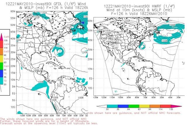
First run by GFDL on 90L gives only 6 hours of life to it.  Of course as time goes on,the data will be more precise and plenty for GFDL and HWRF to have better runs.
http://moe.met.fsu.edu/cgi-bin/gfdltc2. ... =Animation
Fri May 21 13:19:56 EDT 2010
WHXX04 KWBC 211714
CHGQLM
ATTENTION...NATIONAL HURRICANE CENTER
NCEP COUPLED GFDL HURRICANE MODEL FORECAST MADE FOR
TROPICAL DEPRESSION INVEST 90L
INITIAL TIME 12Z MAY 21
DISCLAIMER ... THIS INFORMATION IS PROVIDED AS GUIDANCE. IT
REQUIRES INTERPRETATION BY HURRICANE SPECIALISTS AND SHOULD
NOT BE CONSIDERED AS A FINAL PRODUCT. PLEASE SEE THE TPC/NHC
OFFICIAL FORECAST.
FORECAST STORM POSITION
HOUR LATITUDE LONGITUDE HEADING/SPEED(KT)
0 27.1 72.2 300./ 1.9
6 26.9 72.9 254./ 6.4
STORM DISSIPATED AT 6 HRS AT THE ABOVE PSN
0 likes
Visit the Caribbean-Central America Weather Thread where you can find at first post web cams,radars
and observations from Caribbean basin members Click Here
and observations from Caribbean basin members Click Here
-
Category 5

- Category 5

- Posts: 10074
- Age: 36
- Joined: Sun Feb 11, 2007 10:00 pm
- Location: New Brunswick, NJ
- Contact:
Re: ATL : INVEST 90L - COMPUTER MODELS
Won't see much more model disagreement than that. (first post)
0 likes
-
cycloneye
- Admin
- Posts: 149584
- Age: 69
- Joined: Thu Oct 10, 2002 10:54 am
- Location: San Juan, Puerto Rico
Re: ATL : INVEST 90L - COMPUTER MODELS
0 likes
Visit the Caribbean-Central America Weather Thread where you can find at first post web cams,radars
and observations from Caribbean basin members Click Here
and observations from Caribbean basin members Click Here
-
cycloneye
- Admin
- Posts: 149584
- Age: 69
- Joined: Thu Oct 10, 2002 10:54 am
- Location: San Juan, Puerto Rico
Re: ATL : INVEST 90L - COMPUTER MODELS
12z ECMWF
The 12z EURO run has what looks like a moderate to strong sub or tropical storm.By 240 hours,it will be kicked to the NE by a front but wow,this will last for many days if the EURO is right.
120 hours

168 hours

240 hours

The 12z EURO run has what looks like a moderate to strong sub or tropical storm.By 240 hours,it will be kicked to the NE by a front but wow,this will last for many days if the EURO is right.
120 hours
168 hours
240 hours
0 likes
Visit the Caribbean-Central America Weather Thread where you can find at first post web cams,radars
and observations from Caribbean basin members Click Here
and observations from Caribbean basin members Click Here


-
cycloneye
- Admin
- Posts: 149584
- Age: 69
- Joined: Thu Oct 10, 2002 10:54 am
- Location: San Juan, Puerto Rico
Re: ATL : INVEST 90L - COMPUTER MODELS
0 likes
Visit the Caribbean-Central America Weather Thread where you can find at first post web cams,radars
and observations from Caribbean basin members Click Here
and observations from Caribbean basin members Click Here
-
Hurricaneman

- Category 5
- Posts: 7404
- Age: 45
- Joined: Tue Aug 31, 2004 3:24 pm
- Location: central florida
Re: ATL : INVEST 90L - COMPUTER MODELS
Jeez, that would be a heck of a storm for May, this may need to be watched in later runs
0 likes


-
OuterBanker
- S2K Supporter
- Posts: 1761
- Joined: Wed Feb 26, 2003 10:53 am
- Location: Nags Head, NC
- Contact:
Euro is for wish casters, really ramps it up and keeps it hanging around (don't personally care for where it takes it).
GFS is out to sea (that's the one I'll take)
Euro has been more accurate of late. especially long range forecasts. GFS has been more accurate in short term.
Three cheers for the GFS (may they be right this time).
GFS is out to sea (that's the one I'll take)
Euro has been more accurate of late. especially long range forecasts. GFS has been more accurate in short term.
Three cheers for the GFS (may they be right this time).
0 likes

-
cycloneye
- Admin
- Posts: 149584
- Age: 69
- Joined: Thu Oct 10, 2002 10:54 am
- Location: San Juan, Puerto Rico
Re: ATL : INVEST 90L - COMPUTER MODELS
This second run by GFDL at 18z gives a little more life to 90L,24 hours. Also below is the 18z HWRF loop.
18z GFDL Loop
CHGQLM
ATTENTION...NATIONAL HURRICANE CENTER
NCEP COUPLED GFDL HURRICANE MODEL FORECAST MADE FOR
TROPICAL DEPRESSION INVEST 90L
INITIAL TIME 18Z MAY 21
DISCLAIMER ... THIS INFORMATION IS PROVIDED AS GUIDANCE. IT
REQUIRES INTERPRETATION BY HURRICANE SPECIALISTS AND SHOULD
NOT BE CONSIDERED AS A FINAL PRODUCT. PLEASE SEE THE TPC/NHC
OFFICIAL FORECAST.
FORECAST STORM POSITION
HOUR LATITUDE LONGITUDE HEADING/SPEED(KT)
0 24.8 72.7 165./ 1.9
6 24.4 73.0 218./ 4.9
12 24.0 73.2 207./ 4.0
18 23.6 73.3 191./ 4.3
24 23.2 73.4 192./ 4.4
STORM DISSIPATED AT 24 HRS AT THE ABOVE PSN.
18z HWRF Loop
0 likes
Visit the Caribbean-Central America Weather Thread where you can find at first post web cams,radars
and observations from Caribbean basin members Click Here
and observations from Caribbean basin members Click Here
Who is online
Users browsing this forum: No registered users and 57 guests