BEGIN
NHC_ATCF
invest_al952010.invest
FSTDA
R
U
040
010
0000
201007021236
NONE
NOTIFY=ATRP
END
INVEST, AL, L, , , , , 95, 2010, DB, O, 2010070212, 9999999999, , , , , , METWATCH, , AL952010
AL, 95, 2010070118, , BEST, 0, 306N, 829W, 20, 1009, LO, 0, , 0, 0, 0, 0,
AL, 95, 2010070200, , BEST, 0, 304N, 833W, 20, 1009, LO, 0, , 0, 0, 0, 0,
AL, 95, 2010070206, , BEST, 0, 302N, 836W, 20, 1009, LO, 0, , 0, 0, 0, 0,
AL, 95, 2010070212, , BEST, 0, 300N, 840W, 20, 1015, LO, 34, NEQ, 0, 0, 0, 0, 1018, 150, 15, 0, 0, L, 0, , 0, 0, INVEST, D,
When was the last time it appeared on the map before a thread was made. :o
ATL: INVEST 95L - DISCUSSION
Moderator: S2k Moderators
-
tolakram
- Admin

- Posts: 20186
- Age: 62
- Joined: Sun Aug 27, 2006 8:23 pm
- Location: Florence, KY (name is Mark)
ATL: INVEST 95L - DISCUSSION
0 likes
M a r k
- - - - -
Join us in chat: Storm2K Chatroom Invite. Android and IOS apps also available.
The posts in this forum are NOT official forecasts and should not be used as such. Posts are NOT endorsed by any professional institution or STORM2K.org. For official information and forecasts, please refer to NHC and NWS products.
-
tolakram
- Admin
- Posts: 20186
- Age: 62
- Joined: Sun Aug 27, 2006 8:23 pm
- Location: Florence, KY (name is Mark)
Re: ATL: INVEST 95L - DISCUSSION

0 likes
M a r k
- - - - -
Join us in chat: Storm2K Chatroom Invite. Android and IOS apps also available.
The posts in this forum are NOT official forecasts and should not be used as such. Posts are NOT endorsed by any professional institution or STORM2K.org. For official information and forecasts, please refer to NHC and NWS products.
- - - - -
Join us in chat: Storm2K Chatroom Invite. Android and IOS apps also available.
The posts in this forum are NOT official forecasts and should not be used as such. Posts are NOT endorsed by any professional institution or STORM2K.org. For official information and forecasts, please refer to NHC and NWS products.

Well I personally wouldn't think that much comes from it but a weak sub/tropical system is within the realms of whats possible, esp when the shear eases down. Much depends on exactly how much real estate it creates for itself though really.
0 likes
Personal Forecast Disclaimer:
The posts in this forum are NOT official forecast and should not be used as such. They are just the opinion of the poster and may or may not be backed by sound meteorological data. They are NOT endorsed by any professional institution or storm2k.org. For official information, please refer to the NHC and NWS products
The posts in this forum are NOT official forecast and should not be used as such. They are just the opinion of the poster and may or may not be backed by sound meteorological data. They are NOT endorsed by any professional institution or storm2k.org. For official information, please refer to the NHC and NWS products
-
DTWright

- Tropical Low

- Posts: 37
- Age: 66
- Joined: Sun Jun 27, 2010 4:48 pm
- Location: ( AKA Sabanic ) Mobile, AL
- Contact:
Re: ATL: INVEST 95L - DISCUSSION
All this may do is just make matters much worse as far as the oil is concerned. 32 miles of Alabama and Baldwin county beaches were affected by the oil yesterday.
0 likes

Re: ATL: INVEST 95L - DISCUSSION
DTWright wrote:All this may do is just make matters much worse as far as the oil is concerned. 32 miles of Alabama and Baldwin county beaches were affected by the oil yesterday.
Yes this system will probably get huge attention even if it does end up being a weak system, we just need to hope it stays east, though the track will take it westwards close to the coast.
EVery little bit further south will give it more space and chance to develop. Probably 30-40% overall chance of development based on some keen models.
0 likes
Personal Forecast Disclaimer:
The posts in this forum are NOT official forecast and should not be used as such. They are just the opinion of the poster and may or may not be backed by sound meteorological data. They are NOT endorsed by any professional institution or storm2k.org. For official information, please refer to the NHC and NWS products
The posts in this forum are NOT official forecast and should not be used as such. They are just the opinion of the poster and may or may not be backed by sound meteorological data. They are NOT endorsed by any professional institution or storm2k.org. For official information, please refer to the NHC and NWS products
-
Janie2006

- Category 5

- Posts: 1329
- Joined: Mon Sep 18, 2006 3:28 pm
- Location: coastal Ms aka home of the hurricanes
Re: ATL: INVEST 95L - DISCUSSION
It looks like we've a chance at home brew. If anything forms it's going to be sloppy.....rainy and breezy. The big elephant in the corner of course is the oil.
Although....that vorticity continues to deepen and spread to the SW.
Although....that vorticity continues to deepen and spread to the SW.
Last edited by Janie2006 on Fri Jul 02, 2010 8:26 am, edited 1 time in total.
0 likes

Re: ATL: INVEST 95L - DISCUSSION
New Orleans AFD:
A BLEND OF THE 00Z RUNS OF THE NAM/GFS/ECMWF FORECAST A LOW
PRESSURE SYSTEM TO MOVE WEST-SOUTHWEST FROM THE NORTHEAST GULF
INTO THE NORTH CENTRAL GULF ON SATURDAY...THEN WEST-NORTHWEST
TOWARDS THE SOUTHEAST LOUISIANA COASTAL WATERS...WEST OF SOUTHWEST
PASS...SATURDAY NIGHT. THE GFS IS STILL THE MOST WELL DEVELOPED
WITH A STACKED CIRCULAR PATTERN FROM THE SURFACE UP TO 700 MB WITH
A STRONG WAVE AT 500 MB ABOVE THE LOWER LEVEL CENTER. THE ECMWF IS
NOT THAT MUCH DIFFERENT THAN THE GFS OTHER THAN HAVING MORE OF AN
APPEARANCE OF AN INVERTED TROUGH ON THE SOUTHERN END. THE 06Z RUN
OF THE NAM HAS A STRONG INVERTED TROUGH VERSUS A CLOSED LOW. THE
CANADIAN GEM REMAINS THE ODDBALL RUN SHOWING THE LOW REMAINING
OVER THE NORTHEAST GULF THROUGH SATURDAY NIGHT. AS FAR AS
POTENTIAL TROPICAL DEVELOPMENT...NORTHERLY SHEAR AND DRY AIR ON
THE NORTH SIDE OF THE LOW SHOULD INHIBIT ANY DEEP CONVECTION FROM
WRAPPING AROUND THE LOW CENTER...SO ANY DEVELOPMENT SHOULD BE
SLOW THE NEXT 24 HOURS AT LEAST. HEADING THROUGH THE DAY ON
SATURDAY INTO SATURDAY NIGHT...WILL HAVE TO WATCH AND SEE IF A
COMBINATION OF THINGS CAN HAPPEN. ONE...IF A STACKED SURFACE TO
MID LEVEL LOW PRESSURE AREA DEVELOPS...TWO...IF CONVECTION CAN GET
ORGANIZED NEAR THE LOW CENTER...AND THREE...IF SHEAR WILL RELAX.
THERE IS A GREAT DEAL OF UNCERTAINTY...BUT REAL DATA LATER TODAY
SHOULD GIVE A GOOD CLUE...AND HOPEFULLY THE MODELS WILL INGEST AND
INITIALIZE THE DATA PROPERLY.
0 likes
-
thetruesms

- Professional-Met

- Posts: 844
- Age: 42
- Joined: Thu Aug 16, 2007 1:14 pm
- Location: Tallahasee, FL
- Contact:
I don't think I'm really feeling this one as far as development goes. Although really, even if it gets stuck as a kind of weak low/inverted trough, it will definitely have an impact on spill efforts. It's a shame this is looking to drift west for the time being, because it's actually in a not too terrible spot right now
0 likes


-
wx247

- S2K Supporter

- Posts: 14279
- Age: 42
- Joined: Wed Feb 05, 2003 10:35 pm
- Location: Monett, Missouri
- Contact:
800 AM EDT FRI JUL 2 2010
FOR THE NORTH ATLANTIC...CARIBBEAN SEA AND THE GULF OF MEXICO...
1. A WEAK NON-TROPICAL LOW PRESSURE AREA...ASSOCIATED WITH A FRONTAL
ZONE...CENTERED OVER THE EXTREME NORTHEASTERN GULF OF MEXICO IS
EXPECTED TO DRIFT WESTWARD DURING THE NEXT DAY OR TWO. THIS LOW
WILL BE MONITORED FOR ANY SIGNS OF TROPICAL OR SUBTROPICAL
DEVELOPMENT. THERE IS A LOW CHANCE...10 PERCENT...OF THIS SYSTEM
BECOMING A TROPICAL OR SUBTROPICAL CYCLONE DURING THE NEXT 48
HOURS.
0 likes
Personal Forecast Disclaimer:
The posts in this forum are NOT official forecast and should not be used as such. They are just the opinion of the poster and may or may not be backed by sound meteorological data. They are NOT endorsed by any professional institution or storm2k.org. For official information, please refer to the NHC and NWS products.
The posts in this forum are NOT official forecast and should not be used as such. They are just the opinion of the poster and may or may not be backed by sound meteorological data. They are NOT endorsed by any professional institution or storm2k.org. For official information, please refer to the NHC and NWS products.
-
hurricaneCW
- Category 5
- Posts: 1799
- Joined: Wed Mar 03, 2010 6:20 am
- Location: Toms River, NJ
Re: ATL: INVEST 95L - DISCUSSION
How could it develop if its inland. Even a move towards the west wouldn't really move it into the water.
0 likes
-
HURAKAN

- Professional-Met
- Posts: 46084
- Age: 39
- Joined: Thu May 20, 2004 4:34 pm
- Location: Key West, FL
- Contact:
Re: ATL: INVEST 95L - DISCUSSION
hurricaneCW wrote:How could it develop if its inland. Even a move towards the west wouldn't really move it into the water.
Right now it's moving west-southwest
0 likes
-
hurricaneCW
- Category 5
- Posts: 1799
- Joined: Wed Mar 03, 2010 6:20 am
- Location: Toms River, NJ
Re: ATL: INVEST 95L - DISCUSSION
HURAKAN wrote:hurricaneCW wrote:How could it develop if its inland. Even a move towards the west wouldn't really move it into the water.
Right now it's moving west-southwest
Even so it wouldn't have a lot of breathing room plus the shear is way too high and there is plenty of dry air around. I don't think anything will come out of it but you never know. Any disturbance near the oil spill is bound to cause problems.
0 likes


Little 95L does appear to have warm temps on its side: http://www.nhc.noaa.gov/tafb/atl_anal.gif
0 likes
-
Frank P
- S2K Supporter
- Posts: 2779
- Joined: Fri Aug 29, 2003 10:52 am
- Location: Biloxi Beach, Ms
- Contact:
Re: ATL: INVEST 95L - DISCUSSION
I remembered when min hurricane Danny formed off the SE coast of LA, then moved ENE and sat in Mobile Bay dumping about 30 inches of rain, seemed like it just sat in Mobile bay for at least a day or so..... not saying this is going to do that, but the set up might be similar, its always a possibility, except this time in could be in reverse, from Fl to La.. just some premature speculation on my part.. 
0 likes
Re: ATL: INVEST 95L - DISCUSSION
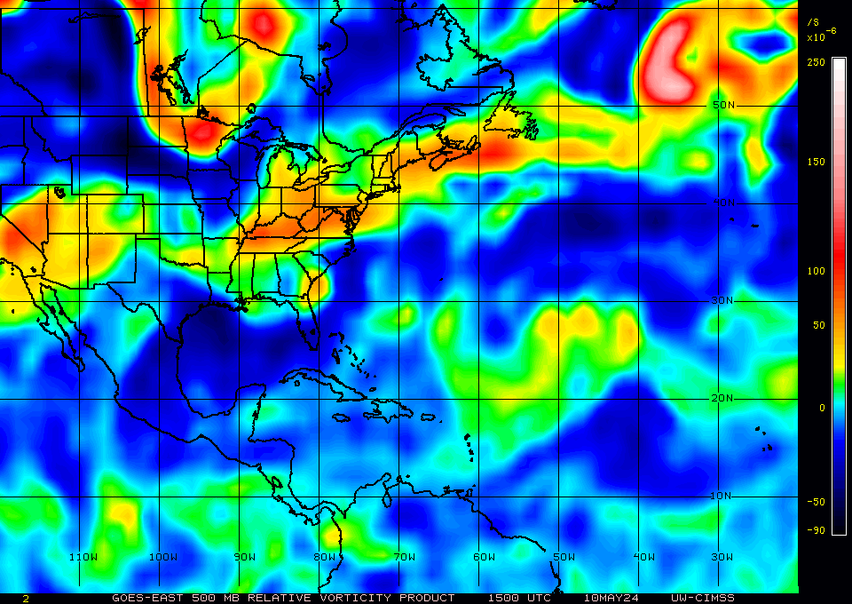
The shear definitely seems to be letting up. Looks like the shear zone is moving off to the west. Once the shear lets up then 95L can worry about fighting the dry air, but not before. You can see on the graphics below that the MLC is definitely displaced south of the LLC.
Shear tendency 5 day movie:
http://cimss.ssec.wisc.edu/tropic2/real-time/atlantic/movies/wg8sht/wg8shtjava.html
850 mb vorticity:

700 mb vorticity:
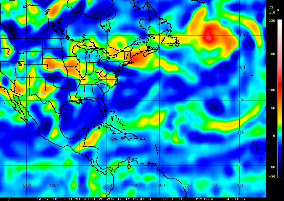
500 mb vorticity:
Shear tendency 5 day movie:
http://cimss.ssec.wisc.edu/tropic2/real-time/atlantic/movies/wg8sht/wg8shtjava.html
850 mb vorticity:
700 mb vorticity:
500 mb vorticity:
0 likes
-
Frank P
- S2K Supporter
- Posts: 2779
- Joined: Fri Aug 29, 2003 10:52 am
- Location: Biloxi Beach, Ms
- Contact:
Re: ATL: INVEST 95L - DISCUSSION
Looks like its moving either due west or just south of west on the latest sat loop presentation... and at a decent clip too...
0 likes
Re: ATL: INVEST 95L - DISCUSSION
Frank P wrote:Looks like its moving either due west or just south of west on the latest sat loop presentation... and at a decent clip too...
That may be bad for development, if it follows the shear.
0 likes
Who is online
Users browsing this forum: No registered users and 44 guests