ATL : TROPICAL DEPRESSION BONNIE - MODELS

Moderator: S2k Moderators

Message
Author
User avatar
cycloneye
Admin
Admin
Posts: 139598
Age: 67
Joined: Thu Oct 10, 2002 10:54 am
Location: San Juan, Puerto Rico

ATL : TROPICAL DEPRESSION BONNIE - MODELS

#1 Postby cycloneye » Mon Jul 19, 2010 5:30 am


WHXX01 KWBC 190909
CHGHUR
TROPICAL CYCLONE GUIDANCE MESSAGE
NWS TPC/NATIONAL HURRICANE CENTER MIAMI FL
0909 UTC MON JUL 19 2010

DISCLAIMER...NUMERICAL MODELS ARE SUBJECT TO LARGE ERRORS.
PLEASE REFER TO NHC OFFICIAL FORECASTS FOR TROPICAL CYCLONE
AND SUBTROPICAL CYCLONE INFORMATION.

ATLANTIC OBJECTIVE AIDS FOR

DISTURBANCE INVEST (AL972010) 20100719 0600 UTC

...00 HRS... ...12 HRS... ...24 HRS. .. ...36 HRS...
100719 0600 100719 1800 100720 0600 100720 1800

LAT LON LAT LON LAT LON LAT LON
BAMS 19.1N 62.4W 20.3N 65.9W 21.3N 69.3W 22.5N 72.7W
BAMD 19.1N 62.4W 20.1N 64.5W 21.0N 66.2W 21.6N 67.9W
BAMM 19.1N 62.4W 20.1N 65.1W 20.7N 67.6W 21.3N 70.1W
LBAR 19.1N 62.4W 19.9N 64.6W 20.6N 67.1W 21.3N 69.8W
SHIP 25KTS 29KTS 33KTS 36KTS
DSHP 25KTS 29KTS 33KTS 36KTS

...48 HRS... ...72 HRS... ...96 HRS. .. ..120 HRS...
100721 0600 100722 0600 100723 0600 100724 0600

LAT LON LAT LON LAT LON LAT LON
BAMS 23.4N 75.6W 24.4N 81.6W 25.3N 87.4W 26.5N 92.3W
BAMD 22.1N 69.3W 22.8N 72.1W 23.8N 75.2W 24.5N 79.8W
BAMM 21.5N 72.3W 21.5N 76.8W 21.8N 80.7W 22.9N 84.3W
LBAR 21.9N 72.7W 22.8N 78.8W 24.0N 83.8W 24.6N 85.9W
SHIP 39KTS 46KTS 56KTS 64KTS
DSHP 39KTS 46KTS 41KTS 44KTS

...INITIAL CONDITIONS...
LATCUR = 19.1N LONCUR = 62.4W DIRCUR = 295DEG SPDCUR = 11KT
LATM12 = 18.1N LONM12 = 60.1W DIRM12 = 297DEG SPDM12 = 14KT
LATM24 = 16.7N LONM24 = 56.7W
WNDCUR = 25KT RMAXWD = 75NM WNDM12 = 20KT
CENPRS = 1014MB OUTPRS = 1017MB OUTRAD = 175NM SDEPTH = S
RD34NE = 0NM RD34SE = 0NM RD34SW = 0NM RD34NW = 0NM

Image
0 likes   
Visit the Caribbean-Central America Weather Thread where you can find at first post web cams,radars
and observations from Caribbean basin members Click Here

User avatar
KWT
Category 5
Category 5
Posts: 31391
Joined: Tue Aug 17, 2004 11:02 am
Location: UK!!!

#2 Postby KWT » Mon Jul 19, 2010 5:37 am

As mad as it sounds I don't think the extrap is going to be that far off from what happens with this system's track.

It's certainly heading towards typical July developmental zone. Upper high should carry on taking this one into the Gulf, the the models are quite keen on lifting the system up as the upper ridge starts to decay...how long that takes will key as to the landfall.
0 likes   
Personal Forecast Disclaimer:
The posts in this forum are NOT official forecast and should not be used as such. They are just the opinion of the poster and may or may not be backed by sound meteorological data. They are NOT endorsed by any professional institution or storm2k.org. For official information, please refer to the NHC and NWS products

KyleEverett
Tropical Low
Tropical Low
Posts: 36
Joined: Sun Jun 27, 2010 9:13 pm

Re: ATL : INVEST 97L - MODELS

#3 Postby KyleEverett » Mon Jul 19, 2010 5:46 am

In the previous thread about this system Ivan posted the DGEX that first hinted at a NOLA from the east hit, but the model run after that showed it recurving into West Florida south of Tampa after entering the gulf.

Considering its an extension of the NAM using GFS data take it as you may.
0 likes   

User avatar
cycloneye
Admin
Admin
Posts: 139598
Age: 67
Joined: Thu Oct 10, 2002 10:54 am
Location: San Juan, Puerto Rico

Re: ATL : INVEST 97L - MODELS

#4 Postby cycloneye » Mon Jul 19, 2010 6:52 am

Nothing strong at the first run of this model,only the track is interesting. By the way,GFDL has nothing yet for 97L as a track nor strengh.

06z HWRF
0 likes   
Visit the Caribbean-Central America Weather Thread where you can find at first post web cams,radars
and observations from Caribbean basin members Click Here

rockyman
Category 5
Category 5
Posts: 1967
Joined: Thu Jun 26, 2003 12:24 pm
Location: Dauphin Island, AL

Re: ATL : INVEST 97L - MODELS

#5 Postby rockyman » Mon Jul 19, 2010 8:06 am

cycloneye wrote:Nothing strong at the first run of this model,only the track is interesting. By the way,GFDL has nothing yet for 97L as a track nor strengh.

06z HWRF


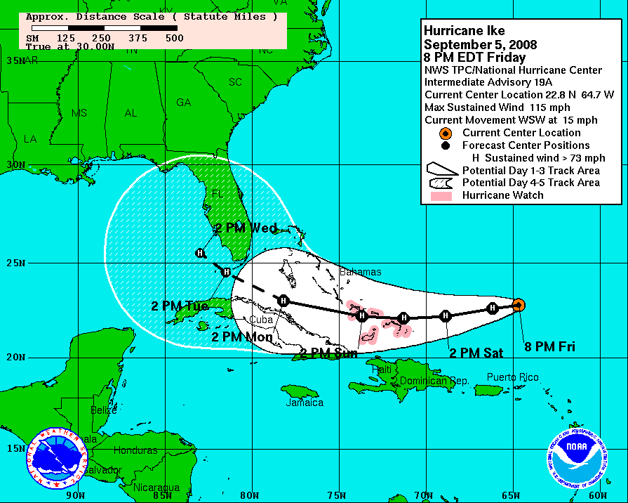
That's an Ike-like track (WSW across Cuba, then back WNW into the Gulf).
IKE PROJECTED PATH WHILE IT WAS NORTH OF PUERTO RICO (THIS IS NOT 97L):
Image
0 likes   

User avatar
petit_bois
Tropical Storm
Tropical Storm
Posts: 227
Joined: Tue Jun 22, 2010 12:04 pm
Location: Petit Bois Island Mississippi

Re: ATL : INVEST 97L - MODELS

#6 Postby petit_bois » Mon Jul 19, 2010 8:55 am

rockyman wrote:
cycloneye wrote:Nothing strong at the first run of this model,only the track is interesting. By the way,GFDL has nothing yet for 97L as a track nor strengh.

06z HWRF


That's an Ike-like track (WSW across Cuba, then back WNW into the Gulf).
IKE PROJECTED PATH WHILE IT WAS NORTH OF PUERTO RICO (THIS IS NOT 97L):
http://www.nhc.noaa.gov/archive/2008/gr ... _019_A.GIF


Hurrican in September can't be compared to a invest in mid July
0 likes   
Resident of the Atlantic Basin's Major Hurricane Hit Capital!
Camille (200+winds), Frederic, Goerges, Katrina... and many many more.

Disclaimer: I'm likely the smartest guy here... but I have no idea where a tropical cyclone will go. I suggest you take my opinion as a grain of salt. I suggest you look to the National Hurricane Center for accurate info.

clfenwi
Category 5
Category 5
Posts: 3331
Joined: Thu Jun 09, 2005 12:54 pm

Re: ATL : INVEST 97L - MODELS

#7 Postby clfenwi » Mon Jul 19, 2010 9:11 am

12z tropical models

Code: Select all

934
WHXX01 KWBC 191407
CHGHUR
TROPICAL CYCLONE GUIDANCE MESSAGE
NWS TPC/NATIONAL HURRICANE CENTER MIAMI FL
1407 UTC MON JUL 19 2010
 
DISCLAIMER...NUMERICAL MODELS ARE SUBJECT TO LARGE ERRORS.
PLEASE REFER TO NHC OFFICIAL FORECASTS FOR TROPICAL CYCLONE
AND SUBTROPICAL CYCLONE INFORMATION.
 
ATLANTIC OBJECTIVE AIDS FOR
 
DISTURBANCE INVEST (AL972010) 20100719 1200 UTC
 
        ...00 HRS...   ...12 HRS...   ...24 HRS. ..   ...36 HRS...
        100719  1200   100720  0000   100720  1200   100721  0000
 
         LAT    LON     LAT    LON     LAT    LON     LAT    LON
BAMS    19.2N  65.0W   20.2N  68.6W   21.3N  72.5W   22.4N  75.7W
BAMD    19.2N  65.0W   19.8N  66.8W   20.3N  68.6W   20.7N  70.3W
BAMM    19.2N  65.0W   19.9N  67.4W   20.3N  69.8W   20.7N  72.1W
LBAR    19.2N  65.0W   20.1N  67.7W   20.8N  70.7W   21.5N  73.6W
SHIP        25KTS          30KTS          36KTS          39KTS
DSHP        25KTS          30KTS          36KTS          39KTS
 
        ...48 HRS...   ...72 HRS...   ...96 HRS. ..   ..120 HRS...
        100721  1200   100722  1200   100723  1200   100724  1200
 
         LAT    LON     LAT    LON     LAT    LON     LAT    LON
BAMS    23.0N  78.9W   24.1N  85.4W   25.6N  91.4W   27.7N  96.1W
BAMD    20.8N  71.9W   21.2N  74.9W   21.9N  78.1W   23.0N  81.8W
BAMM    20.6N  74.4W   20.2N  78.8W   20.4N  82.6W   21.2N  85.9W
LBAR    22.1N  76.6W   23.2N  82.8W   24.7N  88.4W     .0N    .0W
SHIP        42KTS          45KTS          56KTS          66KTS
DSHP        42KTS          45KTS          56KTS          66KTS
 
         ...INITIAL CONDITIONS...
LATCUR =  19.2N LONCUR =  65.0W DIRCUR = 285DEG SPDCUR =  16KT
LATM12 =  18.5N LONM12 =  61.4W DIRM12 = 289DEG SPDM12 =  14KT
LATM24 =  17.4N LONM24 =  58.6W
WNDCUR =   25KT RMAXWD =   75NM WNDM12 =   20KT
CENPRS = 1014MB OUTPRS = 1017MB OUTRAD =  175NM SDEPTH =   S
RD34NE =    0NM RD34SE =    0NM RD34SW =    0NM RD34NW =   0NM
 
$$
NNNN


Image
Last edited by clfenwi on Mon Jul 19, 2010 9:23 am, edited 1 time in total.
0 likes   

rockyman
Category 5
Category 5
Posts: 1967
Joined: Thu Jun 26, 2003 12:24 pm
Location: Dauphin Island, AL

Re: ATL : INVEST 97L - MODELS

#8 Postby rockyman » Mon Jul 19, 2010 9:21 am

petit_bois wrote:
rockyman wrote:
cycloneye wrote:Nothing strong at the first run of this model,only the track is interesting. By the way,GFDL has nothing yet for 97L as a track nor strengh.

06z HWRF


That's an Ike-like track (WSW across Cuba, then back WNW into the Gulf).
IKE PROJECTED PATH WHILE IT WAS NORTH OF PUERTO RICO (THIS IS NOT 97L):
http://www.nhc.noaa.gov/archive/2008/gr ... _019_A.GIF


Hurricane in September can't be compared to a invest in mid July


Sure it can.
0 likes   

User avatar
cycloneye
Admin
Admin
Posts: 139598
Age: 67
Joined: Thu Oct 10, 2002 10:54 am
Location: San Juan, Puerto Rico

Re: ATL : INVEST 97L - MODELS

#9 Postby cycloneye » Mon Jul 19, 2010 9:22 am

SHIP goes to hurricane in 120 hours. Here are the 12z tracks.

Image
0 likes   
Visit the Caribbean-Central America Weather Thread where you can find at first post web cams,radars
and observations from Caribbean basin members Click Here

User avatar
ROCK
Category 5
Category 5
Posts: 9254
Age: 53
Joined: Tue Aug 17, 2004 7:30 am
Location: Kemah, Texas

Re: ATL : INVEST 97L - MODELS

#10 Postby ROCK » Mon Jul 19, 2010 9:26 am

with the high building in the SE in the short and mid term. I WNW track like this is not that crazy...it is July and not August or Sept when you have SV digging enough eroding the high.
0 likes   

Dean4Storms
S2K Supporter
S2K Supporter
Posts: 6356
Age: 61
Joined: Sun Aug 31, 2003 1:01 pm
Location: Miramar Bch. FL

#11 Postby Dean4Storms » Mon Jul 19, 2010 9:44 am

I don't think a track that far south of Florida verifies.
0 likes   

User avatar
ROCK
Category 5
Category 5
Posts: 9254
Age: 53
Joined: Tue Aug 17, 2004 7:30 am
Location: Kemah, Texas

Re:

#12 Postby ROCK » Mon Jul 19, 2010 10:16 am

Dean4Storms wrote:I don't think a track that far south of Florida verifies.


Neither do I but its not going to plow right through the ridge either...
0 likes   

User avatar
Ivanhater
Storm2k Moderator
Storm2k Moderator
Posts: 10859
Age: 37
Joined: Fri Jul 01, 2005 8:25 am
Location: Pensacola

Re: ATL : INVEST 97L - MODELS

#13 Postby Ivanhater » Mon Jul 19, 2010 10:22 am

The OFCI models is interesting...isn't that the "internal NHC track"

Image
0 likes   
Michael

caneman

Re: ATL : INVEST 97L - MODELS

#14 Postby caneman » Mon Jul 19, 2010 10:24 am

No likely it will stay that far South! It shouldn't develop much if it traverses along the North part of the islands as inflow would be interrupted, if not the mountains killing it. We shall see though.
0 likes   

User avatar
ROCK
Category 5
Category 5
Posts: 9254
Age: 53
Joined: Tue Aug 17, 2004 7:30 am
Location: Kemah, Texas

Re: ATL : INVEST 97L - MODELS

#15 Postby ROCK » Mon Jul 19, 2010 10:27 am

Ivanhater wrote:The OFCI models is interesting...isn't that the "internal NHC track"

http://orcasystems.ca/zoo.jpg


nice pic of a EPAC system...Ivan.... :lol:
0 likes   

User avatar
Ivanhater
Storm2k Moderator
Storm2k Moderator
Posts: 10859
Age: 37
Joined: Fri Jul 01, 2005 8:25 am
Location: Pensacola

Re: ATL : INVEST 97L - MODELS

#16 Postby Ivanhater » Mon Jul 19, 2010 10:30 am

Dang it..I'm showing 97L :grr:
0 likes   
Michael

User avatar
A1A
Tropical Storm
Tropical Storm
Posts: 151
Joined: Mon Oct 17, 2005 1:03 pm
Location: Central Texas

Re: ATL : INVEST 97L - MODELS

#17 Postby A1A » Mon Jul 19, 2010 10:34 am

I'm missing something here - I see GOM in Ivan's pics.
0 likes   

User avatar
Nikki
S2K Supporter
S2K Supporter
Posts: 291
Joined: Mon Jun 21, 2010 3:38 pm
Location: Santa Fe, TX (yes I typed that right TEXAS not New Mexico, I am about 20 miles from Galveston, TX)

Re: ATL : INVEST 97L - MODELS

#18 Postby Nikki » Mon Jul 19, 2010 10:36 am

I also see the GOM in Ivan's picture....
0 likes   
My name is Nicole and this is what I go by in Storm2k chat! Come chat with us! We have fun in there too!!

A teacher's purpose is not to create students in her own image, but to develop students who can create their own image. ~Author Unknown

Alicia, Allison, Rita, Ike

User avatar
Ivanhater
Storm2k Moderator
Storm2k Moderator
Posts: 10859
Age: 37
Joined: Fri Jul 01, 2005 8:25 am
Location: Pensacola

Re: ATL : INVEST 97L - MODELS

#19 Postby Ivanhater » Mon Jul 19, 2010 10:38 am

Ok, well the OFCI model (the one with the hurricane symbols), I believe is the internal NHC track. Someone correct me if I'm wrong...
0 likes   
Michael

User avatar
canes101
Tropical Storm
Tropical Storm
Posts: 122
Joined: Mon Jun 14, 2010 7:00 am

Re: ATL : INVEST 97L - MODELS

#20 Postby canes101 » Mon Jul 19, 2010 10:45 am

Ivanhater wrote:Ok, well the OFCI model (the one with the hurricane symbols), I believe is the internal NHC track. Someone correct me if I'm wrong...

No your right..

Image
0 likes   
2010 Archive: HURRICANE ALEX, TD TWO, TS BONNIE, TS COLIN, TD FIVE, HURRICANE DANIELLE, HURRICANE EARL, TS FIONA, TS GASTON, TS HERMINE, HURRICANE IGOR, HURRICANE JULIA, HURRICANE KARL, HURRICANE LISA, TS MATTHEW, TS NICOLE, HURRICANE OTTO, HURRICANE PAULA (Active)


Return to “2010”

Who is online

Users browsing this forum: No registered users and 26 guests