ATL: INVEST 94L - DISCUSSION
Moderator: S2k Moderators


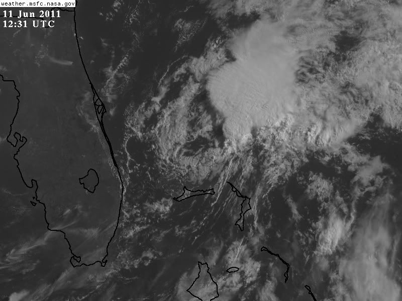
This invest could develop off the Gulf Stream and become a depression. I looked at Tropical Depression One of 09' and it faced harder conditions than 94L. Hold on little buddy, you'll get there. Just keep fighting.
______________________________
Do you Smell what he is COOKING

______________________________
Do you Smell what he is COOKING
0 likes
_____________________
There can be only one Hypercane.....

There can be only one Hypercane.....

Re: ATL: INVEST 94L - DISCUSSION
The 850mb vorticity is the strongest it's been since it's inception.
http://tropic.ssec.wisc.edu/real-time/a ... g8vorZ.GIF
It just happens to be under the most shear MID\Upper level in the basin.
http://tropic.ssec.wisc.edu/real-time/a ... idshrZ.GIF
http://tropic.ssec.wisc.edu/real-time/a ... wg8sht.GIF
If it moves northward as progged conditions get SLIGHTLY better
0 likes
The following post is NOT an official forecast and should not be used as such. It is just the opinion of the poster and may or may not be backed by sound meteorological data. It is NOT endorsed by any professional institution including storm2k.org For Official Information please refer to the NHC and NWS products.
-
wxman57

- Moderator-Pro Met

- Posts: 23172
- Age: 68
- Joined: Sat Jun 21, 2003 8:06 pm
- Location: Houston, TX (southwest)
Re: ATL: INVEST 94L - DISCUSSION
Development chances close to zero. Tremendous shear and SSTs drop fast as it moves north. Already in sub-80F water.
0 likes

000
ABNT20 KNHC 110546
TWOAT
TROPICAL WEATHER OUTLOOK
NWS NATIONAL HURRICANE CENTER MIAMI FL
200 AM EDT SAT JUN 11 2011
FOR THE NORTH ATLANTIC...CARIBBEAN SEA AND THE GULF OF MEXICO...
A SURFACE LOW PRESSURE SYSTEM LOCATED OVER THE NORTHWESTERN BAHAMAS
AND A LARGE UPPER-LEVEL TROUGH OVER THE GULF OF MEXICO ARE
PRODUCING A AREA OF CLOUDINESS AND THUNDERSTORMS THAT EXTENDS FROM
CUBA ACROSS THE BAHAMAS INTO THE ATLANTIC FOR SEVERAL HUNDRED
MILES. UPPER-LEVEL WINDS REMAIN UNFAVORABLE FOR SIGNIFICANT
DEVELOPMENT. THERE IS A LOW CHANCE...10 PERCENT...OF THIS SYSTEM
BECOMING A TROPICAL OR SUBTROPICAL CYCLONE DURING THE NEXT 48 HOURS
AS IT MOVES SLOWLY NORTHWARD OR NORTH-NORTHEASTWARD.
ELSEWHERE...TROPICAL CYCLONE FORMATION IS NOT EXPECTED DURING THE
NEXT 48 HOURS.
$$
FORECASTER BEVEN
0 likes
-
cycloneye

- Admin

- Posts: 149364
- Age: 69
- Joined: Thu Oct 10, 2002 10:54 am
- Location: San Juan, Puerto Rico
Re: ATL: INVEST 94L - DISCUSSION
TROPICAL WEATHER OUTLOOK
NWS NATIONAL HURRICANE CENTER MIAMI FL
800 AM EDT SAT JUN 11 2011
FOR THE NORTH ATLANTIC...CARIBBEAN SEA AND THE GULF OF MEXICO...
AN ELONGATED AREA OF LOW PRESSURE CENTERED OVER THE NORTHWESTERN
BAHAMAS IS PRODUCING CLOUDINESS AND THUNDERSTORMS PRIMARILY OVER
THE ADJACENT ATLANTIC. UPPER-LEVEL WINDS ARE UNFAVORABLE FOR
DEVELOPMENT AND THERE IS A LOW CHANCE...NEAR 0 PERCENT...OF THIS
SYSTEM BECOMING A TROPICAL OR SUBTROPICAL CYCLONE DURING THE NEXT
48 HOURS AS IT MOVES SLOWLY TOWARD THE NORTH OR NORTHEASTWARD.
ELSEWHERE...TROPICAL CYCLONE FORMATION IS NOT EXPECTED DURING THE
NEXT 48 HOURS.
$$
FORECASTER AVILA
0 likes
Visit the Caribbean-Central America Weather Thread where you can find at first post web cams,radars
and observations from Caribbean basin members Click Here
and observations from Caribbean basin members Click Here
-
OuterBanker
- S2K Supporter

- Posts: 1761
- Joined: Wed Feb 26, 2003 10:53 am
- Location: Nags Head, NC
- Contact:
LOL. 94l has the most persistant little llc I've seen in a while. As long as we have that upper level shear it will never develop. It doesn't look like that has even the slightest chance of happening.
Then again it has been a week now and it's still there.
To be honest though, the Atlantic is still too hostile to permit any development.
And very typical I might add.
Then again it has been a week now and it's still there.
To be honest though, the Atlantic is still too hostile to permit any development.
And very typical I might add.
0 likes

-
cycloneye
- Admin
- Posts: 149364
- Age: 69
- Joined: Thu Oct 10, 2002 10:54 am
- Location: San Juan, Puerto Rico
Re: ATL: INVEST 94L - DISCUSSION
For the second time is deactivated
NHC_ATCF
invest_DEACTIVATE_al942011.ren
FSTDA
R
U
040
010
0000
201106121416
NONE
NOTIFY=ATRP
END
NHC_ATCF
invest_DEACTIVATE_al942011.ren
FSTDA
R
U
040
010
0000
201106121416
NONE
NOTIFY=ATRP
END
0 likes
Visit the Caribbean-Central America Weather Thread where you can find at first post web cams,radars
and observations from Caribbean basin members Click Here
and observations from Caribbean basin members Click Here
-
brunota2003

- S2K Supporter
- Posts: 9476
- Age: 35
- Joined: Sat Jul 30, 2005 9:56 pm
- Location: Stanton, KY...formerly Havelock, NC
- Contact:
Re: ATL: INVEST 94L - DISCUSSION
Even though it has been deactivated, it sure does have a tight LLC, and it is moving to the southeast:

0 likes

Re: ATL: INVEST 94L - DISCUSSION
At least it's a sheared LLC at this point...
P.S. It did rain early last evening - a good thunderstorm with 2.75 inches of rain to my west, and enough that it put out the Everglades brush fire - guess my nose was a week slow (lol), but more likely it's a good lesson that God send the help when it's needed, and not when we think it's needed - had the rain come last Monday it would have not been at the right time to put out the fire...
I was out at the fire line yesterday morning and the smoke cloud extended up to approximately 10,000 feet...
Frank
0 likes
-
thetruesms

- Professional-Met

- Posts: 844
- Age: 42
- Joined: Thu Aug 16, 2007 1:14 pm
- Location: Tallahasee, FL
- Contact:
Re: ATL: INVEST 94L - DISCUSSION
well, put out is a little strong, but it is nice to have it almost fully contained and move on to mopup with this one.Frank2 wrote:At least it's a sheared LLC at this point...
P.S. It did rain early last evening - a good thunderstorm with 2.75 inches of rain to my west, and enough that it put out the Everglades brush fire - guess my nose was a week slow (lol), but more likely it's a good lesson that God send the help when it's needed, and not when we think it's needed - had the rain come last Monday it would have not been at the right time to put out the fire...
I was out at the fire line yesterday morning and the smoke cloud extended up to approximately 10,000 feet...
Frank
0 likes
Who is online
Users browsing this forum: No registered users and 21 guests