
Wouldn't the upwelling be more of an issue if this system had lower pressures and higher winds? I suppose if it intensifies and then meanders back and forth over its own track, it would become an issue. Hurricane Georges made its (final) landfall with about a 9' surge after reversing itself over its own track. Maybe the upwelling there was a blessing!! Of course, Georges was quite the storm in its earlier days!!KWT wrote:The only good thing is the heat content isn't that amazing close to the coast. Its good enough for a few days but if this thing just sits there its going to upwell itself into problems...
Of course by that time it could well be a hurricane knocking on the door anyway and any upwelling would be too late.
ATL: LEE - Remnants - Discussion
Moderator: S2k Moderators
Re:
0 likes
Betsy '65, Camille '69, Frederic '79, Elena '85, Georges '98, Isidore '02, Katrina '05, Isaac '12, Nate '17
-
CYCLONE MIKE
- Category 5

- Posts: 2183
- Joined: Tue Aug 31, 2004 6:04 pm
- Location: Gonzales, LA
Re: ATL: INVEST 93L - Discussion
Will definitely be interesting how dry air, shear, and upwelling adversely affects this over the weekend. Anyone have any updated shear maps for the weekend?
0 likes
-
ConvergenceZone
.gif)
- Category 5
- Posts: 5241
- Joined: Fri Jul 29, 2005 1:40 am
- Location: Northern California
Re: ATL: INVEST 93L - Discussion
CYCLONE MIKE wrote:Will definitely be interesting how dry air, shear, and upwelling adversely affects this over the weekend. Anyone have any updated shear maps for the weekend?
I wouldn't worry about the shear as they said that suppose to start to lessen...It's lessened a bit already....
0 likes
-
CYCLONE MIKE
- Category 5
- Posts: 2183
- Joined: Tue Aug 31, 2004 6:04 pm
- Location: Gonzales, LA
Re: ATL: INVEST 93L - Discussion
ConvergenceZone wrote:CYCLONE MIKE wrote:Will definitely be interesting how dry air, shear, and upwelling adversely affects this over the weekend. Anyone have any updated shear maps for the weekend?
I wouldn't worry about the shear as they said that suppose to start to lessen...It's lessened a bit already....
CZ, read yesterday from a few pro's saying shear was supposed to be in the 15-25kt range all thru the weekend. Has this changed?
0 likes
-
Over my head

- Tropical Depression

- Posts: 86
- Joined: Sat Aug 18, 2007 7:52 pm
- Location: Southeast Texas
Re: ATL: INVEST 93L - Discussion
I have been thinking about Humberto this evening. He was sneaky and crept in unexpectedly after midnight. 
0 likes
-
CYCLONE MIKE
- Category 5
- Posts: 2183
- Joined: Tue Aug 31, 2004 6:04 pm
- Location: Gonzales, LA
Re: ATL: INVEST 93L - Models
About 45 minutes ago, they re-ran the tropical models to utilize the revised 18Z best track position that recon helped establish

Code: Select all
WHXX01 KWBC 012232
CHGHUR
TROPICAL CYCLONE GUIDANCE MESSAGE
NWS NATIONAL HURRICANE CENTER MIAMI FL
2232 UTC THU SEP 1 2011

DISCLAIMER...NUMERICAL MODELS ARE SUBJECT TO LARGE ERRORS.
PLEASE REFER TO NHC OFFICIAL FORECASTS FOR TROPICAL CYCLONE
AND SUBTROPICAL CYCLONE INFORMATION.

ATLANTIC OBJECTIVE AIDS FOR

DISTURBANCE THIRTEEN (AL132011) 20110901 1800 UTC

        ...00 HRS...   ...12 HRS...   ...24 HRS. ..   ...36 HRS...
        110901  1800   110902  0600   110902  1800   110903  0600

         LAT    LON     LAT    LON     LAT    LON     LAT    LON
BAMS    26.6N  91.4W   27.2N  93.2W   27.7N  94.5W   27.6N  95.6W
BAMD    26.6N  91.4W   26.9N  92.6W   27.1N  93.5W   27.2N  94.0W
BAMM    26.6N  91.4W   27.1N  92.8W   27.5N  93.9W   27.5N  94.5W
LBAR    26.6N  91.4W   27.0N  92.3W   27.5N  93.3W   28.0N  94.0W
SHIP        30KTS          33KTS          40KTS          46KTS
DSHP        30KTS          33KTS          40KTS          46KTS

        ...48 HRS...   ...72 HRS...   ...96 HRS. ..   ..120 HRS...
        110903  1800   110904  1800   110905  1800   110906  1800

         LAT    LON     LAT    LON     LAT    LON     LAT    LON
BAMS    27.2N  96.1W   26.0N  93.6W   28.9N  89.7W   31.6N  89.9W
BAMD    27.2N  94.3W   27.9N  93.0W   29.7N  91.9W   30.9N  92.4W
BAMM    27.4N  94.6W   28.2N  91.9W   30.8N  90.4W   32.4N  90.9W
LBAR    28.5N  95.0W   29.4N  96.3W   30.2N  97.0W   31.5N  97.2W
SHIP        56KTS          66KTS          68KTS          60KTS
DSHP        56KTS          44KTS          30KTS          27KTS

         ...INITIAL CONDITIONS...
LATCUR =  26.6N LONCUR =  91.4W DIRCUR = 310DEG SPDCUR =   2KT
LATM12 =  25.6N LONM12 =  88.7W DIRM12 = 306DEG SPDM12 =  14KT
LATM24 =  24.1N LONM24 =  87.0W
WNDCUR =   30KT RMAXWD =   75NM WNDM12 =   30KT
CENPRS = 1008MB OUTPRS = 1013MB OUTRAD =  180NM SDEPTH =   M
RD34NE =    0NM RD34SE =    0NM RD34SW =    0NM RD34NW =   0NM

$$
NNNN

0 likes

Re: Re:
Ixolib wrote:Wouldn't the upwelling be more of an issue if this system had lower pressures and higher winds? I suppose if it intensifies and then meanders back and forth over its own track, it would become an issue. Hurricane Georges made its (final) landfall with about a 9' surge after reversing itself over its own track. Maybe the upwelling there was a blessing!! Of course, Georges was quite the storm in its earlier days!!
to an extent but even a weak system is going to induce upwelling and cooling of the SST's if it spends enough time dotted into one place, it just won't make that much difference given a TS doesn't really need much heat content at all...
0 likes
Personal Forecast Disclaimer:
The posts in this forum are NOT official forecast and should not be used as such. They are just the opinion of the poster and may or may not be backed by sound meteorological data. They are NOT endorsed by any professional institution or storm2k.org. For official information, please refer to the NHC and NWS products
The posts in this forum are NOT official forecast and should not be used as such. They are just the opinion of the poster and may or may not be backed by sound meteorological data. They are NOT endorsed by any professional institution or storm2k.org. For official information, please refer to the NHC and NWS products
-
paintplaye
- Category 1

- Posts: 380
- Joined: Sun Jul 20, 2008 11:25 pm
Re:
CYCLONE MIKE wrote:Huge blowup of convection sse of weak llc. Any chance this could get pulled further south into the stronger area of storms tonight or reform?
I was thinking the same but this could also be part of daytime heating and part of the daily thunderstorm explosion on the Yucatan. I have been watching that area all day though and convection is persistent.
0 likes
Re: ATL: INVEST 93L - Models
SHIPS diagnostics for the above run. Note that it assumed the NHC's forecast track (vice BAMM)
(Edited for improved formatting)
Code: Select all
 *   ATLANTIC SHIPS INTENSITY FORECAST       *
                    * GOES AVAILABLE,       OHC AVAILABLE       *
                    *      INVEST  AL932011  09/01/11  18 UTC   *

TIME (HR)          0     6    12    18    24    36    48    60    72    84    96   108   120
V (KT) NO LAND    30    31    32    35    39    45    54    61    66    70    69    68    63
V (KT) LAND       30    31    32    35    39    45    54    61    44    35    30    28    27
V (KT) LGE mod    30    31    31    32    33    36    40    45    36    31    29    27    27
Storm Type      TROP  TROP  TROP  TROP  TROP  TROP  TROP  TROP  TROP  TROP  TROP  TROP  TROP

SHEAR (KT)        19    20    23    21    15    16     6    11    10    11     9    14     7
SHEAR ADJ (KT)    -2     0     1    -2    -6     3     0     0    -1    -2     0    -7    -3
SHEAR DIR        283   274   292   297   274   272   257   259   248   222   267   272   338
SST (C)         30.8  30.8  30.8  30.8  30.7  30.7  30.6  30.4  30.3  30.1  30.1  29.9  29.7
POT. INT. (KT)   172   171   170   168   168   168   168   167   167   166   166   164   161
ADJ. POT. INT.   168   163   158   154   150   150   148   141   138   135   135   134   133
200 MB T (C)   -51.7 -51.5 -51.7 -51.6 -51.3 -50.9 -50.5 -50.1 -50.0 -49.6 -49.7 -49.7 -49.7
TH_E DEV (C)       9    10     8     7     9     7     9     6     9     4     2     0     1
700-500 MB RH     68    62    56    57    57    51    50    48    49    46    42    25    21
GFS VTEX (KT)     10    12    11    13    16    18    22    24    25    26    25    26    24
850 MB ENV VOR     0     0   -15    -6    21    18    60    82   129   114    89    83    84
200 MB DIV        50    63    37    38    79    57    54    48    42    18   -22    -5    -5
700-850 TADV      -6    -4   -10    -4    -1     6     1     4     1    -8    -5    -5     4
LAND (KM)        283   244   205   190   175   138    56     5   -17   -41   -55   -41    -4
LAT (DEG N)     26.6  xx.x  xx.x  xx.x  xx.x  xx.x  xx.x  xx.x  xx.x  xx.x  xx.x  xx.x  xx.x
LONG(DEG W)     91.4 xxx.x xxx.x xxx.x xxx.x xxx.x xxx.x xxx.x xxx.x xxx.x xxx.x xxx.x xxx.x
STM SPEED (KT)    10     8     6     4     3     3     3     2     1     1     1     2     3
HEAT CONTENT     161   112    64    52    37    18     7     2     1    34    36    42     2

  FORECAST TRACK FROM OFPI      INITIAL HEADING/SPEED (DEG/KT):310/  2      CX,CY:  -1/  1
  T-12 MAX WIND:  30            PRESSURE OF STEERING LEVEL (MB):  691  (MEAN=623)
  GOES IR BRIGHTNESS TEMP. STD DEV.  50-200 KM RAD:  20.2 (MEAN=14.5)
  % GOES IR PIXELS WITH T < -20 C    50-200 KM RAD:  22.0 (MEAN=65.0)

                        INDIVIDUAL CONTRIBUTIONS TO INTENSITY CHANGE
                         6   12   18   24   36   48   60   72   84   96  108  120
                        ----------------------------------------------------------
  SAMPLE MEAN CHANGE     1.   2.   3.   4.   6.   8.   9.  11.  12.  12.  13.  13.
  SST POTENTIAL          0.  -1.   0.   1.   5.  11.  18.  22.  26.  29.  31.  32.
  VERTICAL SHEAR MAG     1.   3.   4.   5.   6.   7.   6.   5.   4.   5.   4.   4.
  VERTICAL SHEAR ADJ     0.   0.   0.   1.   1.   1.   1.   1.   2.   2.   2.   1.
  VERTICAL SHEAR DIR     0.   0.   0.   0.   1.   1.   2.   3.   3.   4.   5.   4.
  PERSISTENCE            0.  -1.  -1.  -1.  -1.  -1.  -1.  -1.  -1.   0.   0.   0.
  200/250 MB TEMP.       0.  -1.  -1.  -2.  -3.  -5.  -6.  -8. -10. -11. -13. -15.
  THETA_E EXCESS         0.   0.  -1.  -1.  -1.  -2.  -3.  -4.  -6.  -9. -12. -15.
  700-500 MB RH          0.   0.   0.   0.   0.   0.  -1.   0.   0.   0.   0.   0.
  GFS VORTEX TENDENCY    0.   0.   1.   3.   5.   9.  10.  11.  12.  11.  11.   9.
  850 MB ENV VORTICITY   0.   0.  -1.  -1.  -1.  -1.   0.   1.   2.   3.   4.   4.
  200 MB DIVERGENCE      0.   0.   1.   1.   2.   3.   3.   3.   3.   2.   1.   1.
  850-700 T ADVEC        0.   0.   0.   0.   0.   0.   0.   0.   0.   0.   0.   1.
  ZONAL STORM MOTION     0.   0.   0.   0.  -1.  -1.  -1.  -1.  -2.  -2.  -3.  -3.
  STEERING LEVEL PRES    0.   0.   0.   0.  -1.  -1.  -1.  -1.  -2.  -1.  -1.  -1.
  DAYS FROM CLIM. PEAK   0.   0.   0.   0.   0.   1.   1.   1.   1.   0.   0.   0.
  GOES PREDICTORS       -1.  -2.  -3.  -4.  -5.  -6.  -6.  -6.  -6.  -5.  -4.  -4.
  OCEAN HEAT CONTENT     1.   2.   2.   1.   0.   0.   0.   0.   0.   0.   0.   0.
                        ----------------------------------------------------------
  TOTAL CHANGE           1.   2.   5.   9.  15.  24.  31.  36.  40.  39.  38.  33.

   ** 2011 ATLANTIC RI INDEX AL932011     INVEST 09/01/11  18 UTC **

 12 HR PERSISTENCE (KT):   0.0 Range:-45.0 to  30.0 Scaled/Wgted Val:  0.6/  2.0
 850-200 MB SHEAR (KT) :  19.5 Range: 26.2 to   3.2 Scaled/Wgted Val:  0.3/  0.6
 STD DEV OF IR BR TEMP :  20.2 Range: 34.1 to   3.2 Scaled/Wgted Val:  0.4/  0.9
 D200 (10**7s-1)       :  53.4 Range:-21.0 to 165.0 Scaled/Wgted Val:  0.4/  0.8
 POT = MPI-VMAX (KT)   : 128.5 Range: 33.8 to 126.5 Scaled/Wgted Val:  1.0/  1.1
 850-700 MB REL HUM (%):  70.0 Range: 56.0 to  85.0 Scaled/Wgted Val:  0.5/  0.3
 Heat content (KJ/cm2) :  85.2 Range:  0.0 to 130.0 Scaled/Wgted Val:  0.7/  0.0
 % area w/pixels <-30 C:  15.0 Range: 17.0 to 100.0 Scaled/Wgted Val:  0.0/  0.0

 Prob of RI for 25 kt RI threshold=     4% is   0.3 times the sample mean(12.8%)
 Prob of RI for 30 kt RI threshold=     3% is   0.3 times the sample mean( 8.4%)
 Prob of RI for 35 kt RI threshold=     2% is   0.3 times the sample mean( 5.0%)
 Prob of RI for 40 kt RI threshold=     1% is   0.3 times the sample mean( 3.4%)

   ##         ANNULAR HURRICANE INDEX (AHI) AL932011     INVEST 09/01/11  18 UTC         ##
   ## STORM NOT ANNULAR, SCREENING STEP FAILED, NPASS=4 NFAIL=3                          ##
   ## AHI=  0   (AHI OF 100 IS BEST FIT TO ANN. STRUC., 1 IS MARGINAL, 0 IS NOT ANNULAR) ##

** PROBLTY OF AT LEAST 1 SCNDRY EYEWL FORMTN EVENT AL932011     INVEST 09/01/2011  18 UTC **
TIME(HR)   0-12  12-24(0-24)  24-36(0-36)  36-48(0-48)
CLIMO(%)     0      0(  0)       0(  0)       0(  0)     <-- PROB BASED ON INTENSITY ONLY
PROB(%)      0      0(  0)       0(  0)       0(  0)     <-- FULL MODEL PROB (RAN NORMALLY)
(Edited for improved formatting)
Last edited by clfenwi on Thu Sep 01, 2011 6:24 pm, edited 1 time in total.
0 likes
-
SouthFloridawx

- S2K Supporter

- Posts: 8346
- Age: 47
- Joined: Tue Jul 26, 2005 1:16 am
- Location: Sarasota, FL
- Contact:
Re: ATL: INVEST 93L - Models
Looks like the shear will be a bit better tomorrow and the next day.
0 likes
-
Rgv20

- S2K Supporter
- Posts: 2466
- Age: 39
- Joined: Wed Jan 05, 2011 5:42 pm
- Location: Edinburg/McAllen Tx
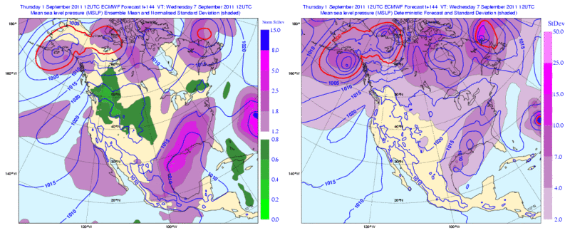
Look at the spread in the 12zECMWF Ensembles at 144hrs, anywhere from South Texas to Mobile AL!! Such a delicate situation..
0 likes
The following post is NOT an official forecast and should not be used as such. It is just the opinion of the poster and may or may not be backed by sound meteorological data. It is NOT endorsed by any professional institution including storm2k.org For Official Information please refer to the NHC and NWS products.

ATL: INVEST 93L - Models
Wow...NWS sure bumped up my rain/wind for this upcoming weekend for my area!(Extreme SE TX Beaumont area).. I wasn't expecting that!
0 likes
-
CYCLONE MIKE
- Category 5
- Posts: 2183
- Joined: Tue Aug 31, 2004 6:04 pm
- Location: Gonzales, LA
Re: ATL: INVEST 93L - Discussion
Looks like it might have pulled some energy from the yucatan but originated in the central gulf. Still blowing up btw. Seems to be the strongest area of convection in the gulf right now. Anyone else have any thoughts?
0 likes
-
CYCLONE MIKE
- Category 5
- Posts: 2183
- Joined: Tue Aug 31, 2004 6:04 pm
- Location: Gonzales, LA
Re: ATL: INVEST 93L - Models
Ships shows pretty slow but steady strengthening. Kind of thought it would intensify quicker once a llc formed and the shear relaxed.
Last edited by CYCLONE MIKE on Thu Sep 01, 2011 6:40 pm, edited 1 time in total.
0 likes
-
SouthFloridawx
- S2K Supporter
- Posts: 8346
- Age: 47
- Joined: Tue Jul 26, 2005 1:16 am
- Location: Sarasota, FL
- Contact:
Re: ATL: INVEST 93L - Models
So it's officially Tropical Depression 13L.
422
WHXX01 KWBC 012232
CHGHUR
TROPICAL CYCLONE GUIDANCE MESSAGE
NWS NATIONAL HURRICANE CENTER MIAMI FL
2232 UTC THU SEP 1 2011
DISCLAIMER...NUMERICAL MODELS ARE SUBJECT TO LARGE ERRORS.
PLEASE REFER TO NHC OFFICIAL FORECASTS FOR TROPICAL CYCLONE
AND SUBTROPICAL CYCLONE INFORMATION.
ATLANTIC OBJECTIVE AIDS FOR
DISTURBANCE THIRTEEN (AL132011) 20110901 1800 UTC
...00 HRS... ...12 HRS... ...24 HRS. .. ...36 HRS...
110901 1800 110902 0600 110902 1800 110903 0600
LAT LON LAT LON LAT LON LAT LON
BAMS 26.6N 91.4W 27.2N 93.2W 27.7N 94.5W 27.6N 95.6W
BAMD 26.6N 91.4W 26.9N 92.6W 27.1N 93.5W 27.2N 94.0W
BAMM 26.6N 91.4W 27.1N 92.8W 27.5N 93.9W 27.5N 94.5W
LBAR 26.6N 91.4W 27.0N 92.3W 27.5N 93.3W 28.0N 94.0W
SHIP 30KTS 33KTS 40KTS 46KTS
DSHP 30KTS 33KTS 40KTS 46KTS
...48 HRS... ...72 HRS... ...96 HRS. .. ..120 HRS...
110903 1800 110904 1800 110905 1800 110906 1800
LAT LON LAT LON LAT LON LAT LON
BAMS 27.2N 96.1W 26.0N 93.6W 28.9N 89.7W 31.6N 89.9W
BAMD 27.2N 94.3W 27.9N 93.0W 29.7N 91.9W 30.9N 92.4W
BAMM 27.4N 94.6W 28.2N 91.9W 30.8N 90.4W 32.4N 90.9W
LBAR 28.5N 95.0W 29.4N 96.3W 30.2N 97.0W 31.5N 97.2W
SHIP 56KTS 66KTS 68KTS 60KTS
DSHP 56KTS 44KTS 30KTS 27KTS
...INITIAL CONDITIONS...
LATCUR = 26.6N LONCUR = 91.4W DIRCUR = 310DEG SPDCUR = 2KT
LATM12 = 25.6N LONM12 = 88.7W DIRM12 = 306DEG SPDM12 = 14KT
LATM24 = 24.1N LONM24 = 87.0W
WNDCUR = 30KT RMAXWD = 75NM WNDM12 = 30KT
CENPRS = 1008MB OUTPRS = 1013MB OUTRAD = 180NM SDEPTH = M
RD34NE = 0NM RD34SE = 0NM RD34SW = 0NM RD34NW = 0NM
$$
NNNN
0 likes
-
SouthFloridawx
- S2K Supporter
- Posts: 8346
- Age: 47
- Joined: Tue Jul 26, 2005 1:16 am
- Location: Sarasota, FL
- Contact:
Re: ATL: INVEST 93L - Discussion
422
WHXX01 KWBC 012232
CHGHUR
TROPICAL CYCLONE GUIDANCE MESSAGE
NWS NATIONAL HURRICANE CENTER MIAMI FL
2232 UTC THU SEP 1 2011
DISCLAIMER...NUMERICAL MODELS ARE SUBJECT TO LARGE ERRORS.
PLEASE REFER TO NHC OFFICIAL FORECASTS FOR TROPICAL CYCLONE
AND SUBTROPICAL CYCLONE INFORMATION.
ATLANTIC OBJECTIVE AIDS FOR
DISTURBANCE THIRTEEN (AL132011) 20110901 1800 UTC
...00 HRS... ...12 HRS... ...24 HRS. .. ...36 HRS...
110901 1800 110902 0600 110902 1800 110903 0600
LAT LON LAT LON LAT LON LAT LON
BAMS 26.6N 91.4W 27.2N 93.2W 27.7N 94.5W 27.6N 95.6W
BAMD 26.6N 91.4W 26.9N 92.6W 27.1N 93.5W 27.2N 94.0W
BAMM 26.6N 91.4W 27.1N 92.8W 27.5N 93.9W 27.5N 94.5W
LBAR 26.6N 91.4W 27.0N 92.3W 27.5N 93.3W 28.0N 94.0W
SHIP 30KTS 33KTS 40KTS 46KTS
DSHP 30KTS 33KTS 40KTS 46KTS
0 likes
-
PTrackerLA

- Category 5
- Posts: 5281
- Age: 42
- Joined: Thu Oct 10, 2002 8:40 pm
- Location: Lafayette, LA
Re: ATL: INVEST 93L - Models
Looks like SHIPS takes it up to a 75mph hurricane. I can't wait to see the official track for this one  .
.
0 likes
-
PTrackerLA
- Category 5
- Posts: 5281
- Age: 42
- Joined: Thu Oct 10, 2002 8:40 pm
- Location: Lafayette, LA
Re: ATL: INVEST 93L - Models
Saw the models! All have shifted East (again) GGGRRRR...... 
I give up....we're losing our battle Texas! LA....Have fun!
I give up....we're losing our battle Texas! LA....Have fun!
0 likes
Who is online
Users browsing this forum: No registered users and 41 guests