ATL: NATE - Remnants - Discussion

Moderator: S2k Moderators

Message
Author
User avatar
WxGuy1
Professional-Met
Professional-Met
Posts: 538
Joined: Sat Oct 22, 2005 12:55 pm
Location: Oklahoma

Re:

#141 Postby WxGuy1 » Wed Sep 07, 2011 1:33 am

Rgv20 wrote:IMO if 96L develops close to the NW Yucatan than odd are it would take the NE option as suggested by the 12zECMWF and 0zCMC but if it were to develop more south than a more WNW heading would be likely like the GFS and NAM are forecasting.


Based entirely on anecdotal evidence (e.g. remembering past tropical cyclones in the area), I agree with your assessment. I don't recall many (if any) instances of a tropical cyclone in the BoC (at a latitude south of the northern tip of the Yucatan peninsula in the Gulf of Mexico) that ended up moving northeastward and making landfall in the eastern or northeastern GoM. Now, I'm sure it has happened before, but it seems like the vast majority of the time, tropical cyclones in the BoC end up heading westward into Mexico, with some isolated instances of storms heading northwestward and making landfall in extreme southern Texas. The 00z GFS and 00z HWRF develop a cyclone in the BoC and, eventually, move it westward into Mexico. The 00z CMC (which tends to spin up way too many lows into raging cyclones it seems) is farther north, and ends up taking 96L into the northern GoM. Interestingly, the 12z ECMWF (haven't seen the 00z yet) develops 96L at a relatively low latitude in the BoC, yet still ends up moving it northward and making landfall in the northern GoM.

So, the end result is that the forecast is very uncertain. This shouldn't be surprising, though, since we don't even have a tropical cyclone yet. The variability amongst the ensemble members (SREF, GFS global ensembles, etc.) is very large, although none that I've seen yet indicate that Texas is a candidate for seeing much rainfall from whatever is to become of 96L.

EDIT:
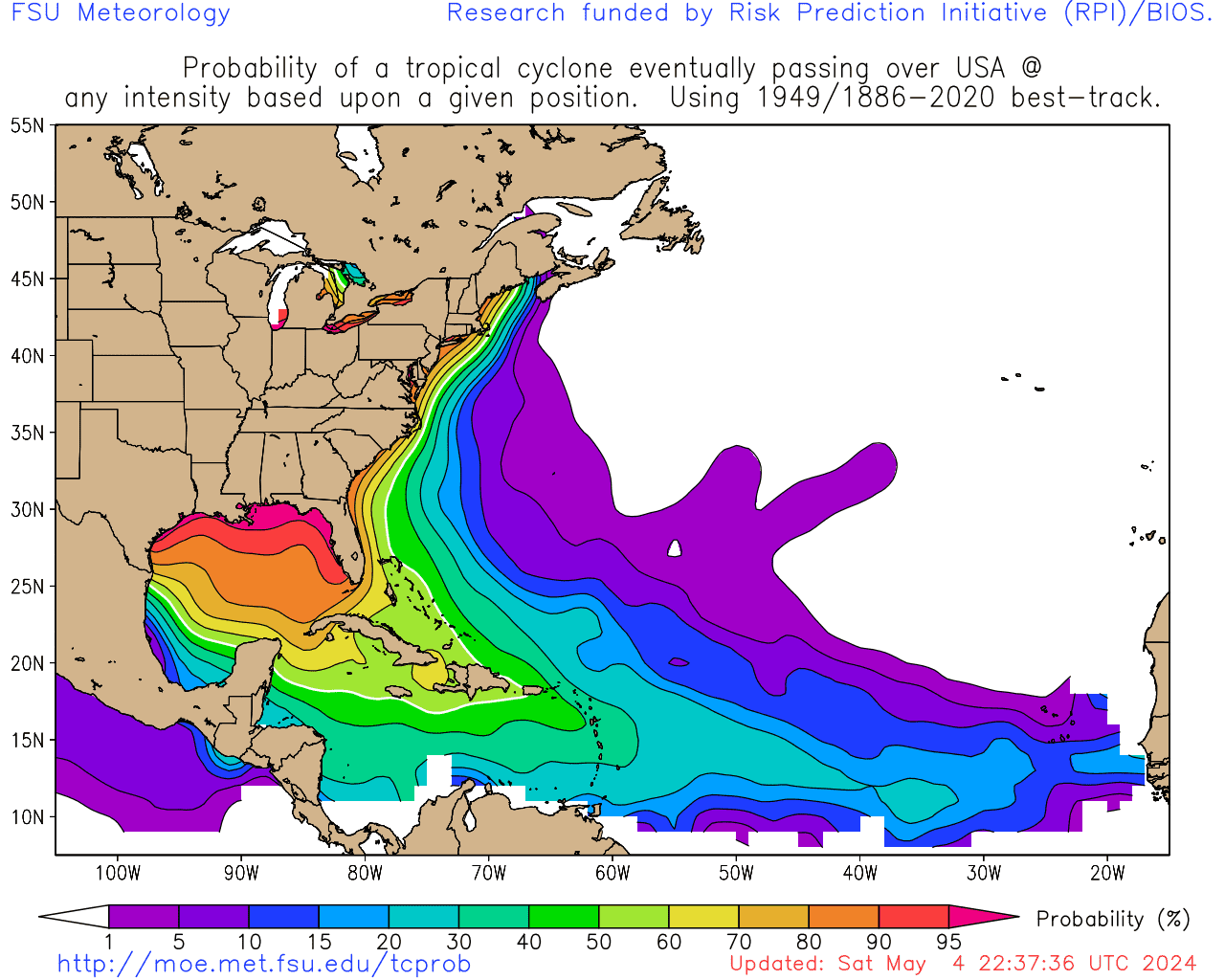
Based on THIS PLOT, my observation above is relatively accurate -- for cyclones that are essentially south of the northern tip of the Yucatan, there is a <50% probability of a U.S. landfall based on historical data. The probability rapid increases for those cyclones that occur at and north of the latitude of the tip of the Yucatan. Just FYI. Note also that storms in TD14's current location have had a ~30% of hitting the U.S., but that's for another thread.
0 likes   

maxintensity
Tropical Storm
Tropical Storm
Posts: 165
Joined: Tue Aug 02, 2011 9:54 pm

#142 Postby maxintensity » Wed Sep 07, 2011 1:49 am

Euro shows Lee #2 although it does hit LA as a hurricane. Just sits there for days.
0 likes   

User avatar
Kohlecane
Category 2
Category 2
Posts: 567
Age: 32
Joined: Sun Jul 31, 2011 11:03 pm
Location: Beaufort, SC

Re: ATL: INVEST 96L - Discussion

#143 Postby Kohlecane » Wed Sep 07, 2011 2:29 am

OK first of all .............. and that's what im going to leave you with, cause i dont wanna get banned from here but that is BOGUSSSSSSSSSSSSS\
0 likes   
Once I see the REDS and GREENS Converge on a Base Velocity. ... I'm There!!

This is NOT an Official Forecast....Just my Opinion. For official information, please refer to the NHC and NWS products.
HIGHLIGHTS : '13 El Reno Tornado : 2013 Storm Chaser Tour, Joaquin; SC flood event, Matthew '16, Lowcountry Snow storm Jan '18

User avatar
LaBreeze
Category 5
Category 5
Posts: 1497
Joined: Thu Sep 04, 2003 1:57 pm
Location: SW Louisiana

Re:

#144 Postby LaBreeze » Wed Sep 07, 2011 4:18 am

maxintensity wrote:Euro shows Lee #2 although it does hit LA as a hurricane. Just sits there for days.

How believable is the Euro? What is the time frame that it shows concerning this, what part of LA, and what strength is it showing at this time? I know this is way out in the future, but I was just wondering since I'm not very good at reading models. Thanks in advance.
0 likes   

User avatar
KWT
Category 5
Category 5
Posts: 31391
Joined: Tue Aug 17, 2004 11:02 am
Location: UK!!!

#145 Postby KWT » Wed Sep 07, 2011 4:44 am

The ECM certainly stands out for its forecast, alot slower motion this run. GFS continues to bury this into Mexico which maybe a slightly more realistic solution...
0 likes   
Personal Forecast Disclaimer:
The posts in this forum are NOT official forecast and should not be used as such. They are just the opinion of the poster and may or may not be backed by sound meteorological data. They are NOT endorsed by any professional institution or storm2k.org. For official information, please refer to the NHC and NWS products

User avatar
Cyclenall
Category 5
Category 5
Posts: 6628
Joined: Thu Jun 08, 2006 10:01 pm
Location: Ontario, Canada

Re: ATL: INVEST 96L - Models

#146 Postby Cyclenall » Wed Sep 07, 2011 4:48 am

bigdan35 wrote:It dont look that bad.

[img]http://img716.imageshack.us/img716/4973/slp19.png[ /img]

Uploaded with [url=http://imageshack.us]ImageShack.us[ /url]

That looks really bad, nearly a major hurricane possibly into the soaked regions of the Gulf coast. Not to mention future Maria slamming the islands big time.
0 likes   

User avatar
KWT
Category 5
Category 5
Posts: 31391
Joined: Tue Aug 17, 2004 11:02 am
Location: UK!!!

#147 Postby KWT » Wed Sep 07, 2011 4:56 am

CMC is quite strong, ECM is probably a 2/3, GFS also probably makes a weak hurricane though it buries itself into land near where Karl made landfall last year.
0 likes   
Personal Forecast Disclaimer:
The posts in this forum are NOT official forecast and should not be used as such. They are just the opinion of the poster and may or may not be backed by sound meteorological data. They are NOT endorsed by any professional institution or storm2k.org. For official information, please refer to the NHC and NWS products

User avatar
KWT
Category 5
Category 5
Posts: 31391
Joined: Tue Aug 17, 2004 11:02 am
Location: UK!!!

#148 Postby KWT » Wed Sep 07, 2011 5:00 am

Its quite logical that there'd be alot of dry air around given you've got a very severe drought going on in Texas, sorta quite logical really...
0 likes   
Personal Forecast Disclaimer:
The posts in this forum are NOT official forecast and should not be used as such. They are just the opinion of the poster and may or may not be backed by sound meteorological data. They are NOT endorsed by any professional institution or storm2k.org. For official information, please refer to the NHC and NWS products

Javlin
Category 5
Category 5
Posts: 1568
Age: 63
Joined: Fri Jul 09, 2004 7:58 pm
Location: ms gulf coast

#149 Postby Javlin » Wed Sep 07, 2011 6:13 am

For what it is worth 06 NAM in the center of the GOM @84hrs

http://raleighwx.americanwx.com/models/ ... ort084.gif
0 likes   

rockyman
Category 5
Category 5
Posts: 1967
Joined: Thu Jun 26, 2003 12:24 pm
Location: Dauphin Island, AL

ATL: INVEST 96L - Discussion

#150 Postby rockyman » Wed Sep 07, 2011 6:37 am

From Crowne this morning:

So, my thinking is that we will have a tropical storm develop in the far southern Gulf of Mexico within the next 24 to 36 hours. From there, I think we will see a slow northward track this weekend with this system intensifying possibly into a hurricane. I think the European model may be too quick in its track into the northern Gulf coast and a track inland somewhere between the central Louisiana coast and the western Florida Panhandle on Tuesday or Wednesday as a hurricane is quite possible.

Read entire discussion here:
http://www.crownweather.com/index.php?page_id=4557
0 likes   

clfenwi
Category 5
Category 5
Posts: 3331
Joined: Thu Jun 09, 2005 12:54 pm

Re: ATL: INVEST 96L - Models

#151 Postby clfenwi » Wed Sep 07, 2011 6:46 am

06Z HWRF keeps the same idea it had in the 00Z run.

ATTENTION...NATIONAL HURRICANE CENTER

NCEP COUPLED HWRF HURRICANE MODEL FORECAST MADE FOR

TROPICAL DEPRESSION INVEST 96L

INITIAL TIME 6Z SEP 7

FORECAST POSITIONS (FROM STATS.SHORT FILE...)

HOUR LATITUDE LONGITUDE MIN PRESS (hPa) MAX SFC WIND (KTS)

HOUR: 0.0 LONG: -93.20 LAT: 20.50 MIN PRESS (hPa): 1006.00 MAX SURF WIND (KNOTS): 25.00
HOUR: 6.0 LONG: -92.90 LAT: 20.10 MIN PRESS (hPa): 1008.00 MAX SURF WIND (KNOTS): 30.00
HOUR: 12.0 LONG: -92.70 LAT: 20.00 MIN PRESS (hPa): 1008.00 MAX SURF WIND (KNOTS): 31.00
HOUR: 18.0 LONG: -92.30 LAT: 19.90 MIN PRESS (hPa): 1007.00 MAX SURF WIND (KNOTS): 35.00
HOUR: 24.0 LONG: -92.00 LAT: 20.00 MIN PRESS (hPa): 1005.00 MAX SURF WIND (KNOTS): 33.00
HOUR: 30.0 LONG: -92.00 LAT: 19.90 MIN PRESS (hPa): 1003.00 MAX SURF WIND (KNOTS): 41.00
HOUR: 36.0 LONG: -91.60 LAT: 20.10 MIN PRESS (hPa): 1001.00 MAX SURF WIND (KNOTS): 43.00
HOUR: 42.0 LONG: -91.60 LAT: 20.40 MIN PRESS (hPa): 999.00 MAX SURF WIND (KNOTS): 44.00
HOUR: 48.0 LONG: -91.60 LAT: 20.70 MIN PRESS (hPa): 993.00 MAX SURF WIND (KNOTS): 49.00
HOUR: 54.0 LONG: -91.60 LAT: 21.00 MIN PRESS (hPa): 989.00 MAX SURF WIND (KNOTS): 52.00
HOUR: 60.0 LONG: -91.50 LAT: 21.50 MIN PRESS (hPa): 982.00 MAX SURF WIND (KNOTS): 59.00
HOUR: 66.0 LONG: -91.60 LAT: 22.00 MIN PRESS (hPa): 978.00 MAX SURF WIND (KNOTS): 62.00
HOUR: 72.0 LONG: -91.70 LAT: 22.50 MIN PRESS (hPa): 972.00 MAX SURF WIND (KNOTS): 69.00
HOUR: 78.0 LONG: -91.80 LAT: 23.00 MIN PRESS (hPa): 971.00 MAX SURF WIND (KNOTS): 71.00
HOUR: 84.0 LONG: -91.90 LAT: 23.30 MIN PRESS (hPa): 968.00 MAX SURF WIND (KNOTS): 79.00
HOUR: 90.0 LONG: -92.10 LAT: 23.60 MIN PRESS (hPa): 967.00 MAX SURF WIND (KNOTS): 83.00
HOUR: 96.0 LONG: -92.40 LAT: 23.70 MIN PRESS (hPa): 965.00 MAX SURF WIND (KNOTS): 80.00
HOUR: 102.0 LONG: -92.60 LAT: 23.80 MIN PRESS (hPa): 968.00 MAX SURF WIND (KNOTS): 80.00
HOUR: 108.0 LONG: -93.10 LAT: 23.80 MIN PRESS (hPa): 966.00 MAX SURF WIND (KNOTS): 79.00
HOUR: 114.0 LONG: -93.40 LAT: 23.60 MIN PRESS (hPa): 966.00 MAX SURF WIND (KNOTS): 87.00
HOUR: 120.0 LONG: -93.80 LAT: 23.40 MIN PRESS (hPa): 960.00 MAX SURF WIND (KNOTS): 81.00
HOUR: 126.0 LONG: -94.20 LAT: 23.00 MIN PRESS (hPa): 958.00 MAX SURF WIND (KNOTS): 94.00
FORECAST RAN UNCOUPLED


Image

Loop
0 likes   

rockyman
Category 5
Category 5
Posts: 1967
Joined: Thu Jun 26, 2003 12:24 pm
Location: Dauphin Island, AL

ATL: INVEST 96L - Discussion

#152 Postby rockyman » Wed Sep 07, 2011 6:46 am

Code red 60%

A BROAD AREA OF LOW PRESSURE LOCATED OVER THE EXTREME SOUTHWESTERN
GULF OF MEXICO IS SHOWING SOME SIGNS OF ORGANIZATION. ENVIRONMENTAL
CONDITIONS APPEAR FAVORABLE FOR DEVELOPMENT AND THIS SYSTEM COULD
BECOME A TROPICAL DEPRESSION DURING THE NEXT DAY OR SO. THIS
SYSTEM HAS A HIGH CHANCE...60 PERCENT...OF BECOMING A TROPICAL
CYCLONE AS IT MOVES LITTLE DURING THE NEXT 48 HOURS. AN AIR FORCE
RESERVE HURRICANE HUNTER AIRCRAFT IS SCHEDULED TO INVESTIGATE LOW THIS AFTERNOON...IF NECESSARY.
0 likes   

clfenwi
Category 5
Category 5
Posts: 3331
Joined: Thu Jun 09, 2005 12:54 pm

Re: ATL: INVEST 96L - Models

#153 Postby clfenwi » Wed Sep 07, 2011 6:55 am

06Z GFDL, 18Z run brought it into the Pacific, 00Z run lost the circulation. This looks to be similar to the GFS, winding the storm down before it reaches the coast of Mexico

HOUR: .0 LONG: -93.10 LAT: 20.72 MIN PRESS (hPa): 1008.18 MAX SURF WIND (KNOTS): 29.48
HOUR: 6.0 LONG: -93.23 LAT: 20.42 MIN PRESS (hPa): 1003.89 MAX SURF WIND (KNOTS): 41.32
HOUR: 12.0 LONG: -93.19 LAT: 20.16 MIN PRESS (hPa): 1002.39 MAX SURF WIND (KNOTS): 47.37
HOUR: 18.0 LONG: -92.95 LAT: 19.89 MIN PRESS (hPa): 998.48 MAX SURF WIND (KNOTS): 44.95
HOUR: 24.0 LONG: -92.88 LAT: 19.78 MIN PRESS (hPa): 996.79 MAX SURF WIND (KNOTS): 41.28
HOUR: 30.0 LONG: -92.95 LAT: 19.73 MIN PRESS (hPa): 993.92 MAX SURF WIND (KNOTS): 47.75
HOUR: 36.0 LONG: -92.88 LAT: 19.63 MIN PRESS (hPa): 990.60 MAX SURF WIND (KNOTS): 52.86
HOUR: 42.0 LONG: -92.86 LAT: 19.44 MIN PRESS (hPa): 985.40 MAX SURF WIND (KNOTS): 62.00
HOUR: 48.0 LONG: -92.69 LAT: 19.29 MIN PRESS (hPa): 983.08 MAX SURF WIND (KNOTS): 64.12
HOUR: 54.0 LONG: -92.70 LAT: 19.62 MIN PRESS (hPa): 981.36 MAX SURF WIND (KNOTS): 59.14
HOUR: 60.0 LONG: -92.78 LAT: 19.83 MIN PRESS (hPa): 981.18 MAX SURF WIND (KNOTS): 55.96
HOUR: 66.0 LONG: -92.83 LAT: 20.19 MIN PRESS (hPa): 982.66 MAX SURF WIND (KNOTS): 51.30
HOUR: 72.0 LONG: -93.33 LAT: 20.23 MIN PRESS (hPa): 982.63 MAX SURF WIND (KNOTS): 54.53
HOUR: 78.0 LONG: -93.81 LAT: 20.40 MIN PRESS (hPa): 981.91 MAX SURF WIND (KNOTS): 58.27
HOUR: 84.0 LONG: -93.97 LAT: 20.41 MIN PRESS (hPa): 981.37 MAX SURF WIND (KNOTS): 57.68
HOUR: 90.0 LONG: -94.27 LAT: 20.40 MIN PRESS (hPa): 981.52 MAX SURF WIND (KNOTS): 56.89
HOUR: 96.0 LONG: -94.51 LAT: 20.16 MIN PRESS (hPa): 980.24 MAX SURF WIND (KNOTS): 67.56
HOUR:102.0 LONG: -94.99 LAT: 20.41 MIN PRESS (hPa): 978.16 MAX SURF WIND (KNOTS): 80.81
HOUR:108.0 LONG: -95.73 LAT: 20.51 MIN PRESS (hPa): 980.02 MAX SURF WIND (KNOTS): 83.25
HOUR:114.0 LONG: -96.43 LAT: 20.22 MIN PRESS (hPa): 983.60 MAX SURF WIND (KNOTS): 78.39
HOUR:120.0 LONG: -96.40 LAT: 20.13 MIN PRESS (hPa): 1005.42 MAX SURF WIND (KNOTS): 35.79
-99.9 -99.90 -99.90


Wind swath

Image


Loop (as of this moment images haven't loaded yet, but they will)
0 likes   

clfenwi
Category 5
Category 5
Posts: 3331
Joined: Thu Jun 09, 2005 12:54 pm

ATL: NATE - Recon Discussion

#154 Postby clfenwi » Wed Sep 07, 2011 7:07 am

Please put questions and comments in this thread. First mission, assuming it is a go, launches at 1500Z / 1000 CDT for an 18Z fix.
0 likes   

User avatar
northjaxpro
S2K Supporter
S2K Supporter
Posts: 8900
Joined: Mon Sep 27, 2010 11:21 am
Location: Jacksonville, FL

#155 Postby northjaxpro » Wed Sep 07, 2011 7:09 am

Yeah, convection is gradually building around the surface circulation of 96L this morning. As a matter of fact, the satellite appearance is the best I have seen yet, despite the dry air pressing down on the system from the north. The south and southwest inflow into the system from the Eastern Pacific is providing sufficient juice to kick start 96L for the short term to allow for development. Also, very little movement expected from 96L for the next 48 hours.

Here is the 8 a.m. TWD excerpt on 96L from NHC:

THE 1007 MB SURFACE LOW IS CENTERED IN THE S GULF OF MEXICO NEAR
21N93W AT 07/0900 UTC AND REMAINS AT THE TAIL END OF A
QUASI-STATIONARY FRONTAL BOUNDARY.
CLUSTERS OF SCATTERED
MODERATE/ISOLATED STRONG CONVECTION ARE S OF 22N TO INLAND OVER
S MEXICO BETWEEN 92W-96W. THIS SYSTEM IS SHOWING SOME SIGNS OF
ORGANIZATION. ENVIRONMENTAL CONDITIONS APPEAR FAVORABLE FOR
DEVELOPMENT. IT IS POSSIBLE THAT THIS FEATURE MAY BECOME
A TROPICAL DEPRESSION DURING THE NEXT 48 HOURS. IT IS FORECAST
TO MOVE LITTLE DURING THE NEXT 48 HOURS.
0 likes   
NEVER, EVER SAY NEVER in the tropics and weather in general, and most importantly, with life itself!!

________________________________________________________________________________________

Fay 2008 Beryl 2012 Debby 2012 Colin 2016 Hermine 2016 Julia 2016 Matthew 2016 Irma 2017 Dorian 2019

clfenwi
Category 5
Category 5
Posts: 3331
Joined: Thu Jun 09, 2005 12:54 pm

ATL: NATE - Recon

#156 Postby clfenwi » Wed Sep 07, 2011 7:09 am

Mission scheduled for today. HDOBS, RECCO observations, dropsondes and Vortex messages go here.

2. SUSPECT AREA (GULF OF MEXICO)
FLIGHT ONE -- TEAL 75
A. 07/1800Z
B. AFXXX 01IIA INVEST
C. 07/1500Z
D. 20.5N 92.0W
E. 07/1730Z TO 07/2200Z
F. SFC TO 10,000 FT


Please post comment questions in the topic below

http://www.storm2k.org/phpbb2/viewtopic.php?f=59&t=111819
0 likes   

clfenwi
Category 5
Category 5
Posts: 3331
Joined: Thu Jun 09, 2005 12:54 pm

Re: ATL: INVEST 96L - Discussion

#157 Postby clfenwi » Wed Sep 07, 2011 7:36 am

SSD Dvorak estimate

07/1145 UTC 20.0N 93.2W T1.0/1.0 96L

Visible

Image

12Z Best track

AL, 96, 2011090712, , BEST, 0, 200N, 934W, 25, 1007, DB,
0 likes   

User avatar
Rgv20
S2K Supporter
S2K Supporter
Posts: 2458
Age: 37
Joined: Wed Jan 05, 2011 5:42 pm
Location: Edinburg/McAllen Tx

Re: Re:

#158 Postby Rgv20 » Wed Sep 07, 2011 7:37 am

WxGuy1 wrote:
So, the end result is that the forecast is very uncertain. This shouldn't be surprising, though, since we don't even have a tropical cyclone yet. The variability amongst the ensemble members (SREF, GFS global ensembles, etc.) is very large, although none that I've seen yet indicate that Texas is a candidate for seeing much rainfall from whatever is to become of 96L.


Unfortunately your right it looks like its going to be tough for Texas to get some Rain out of 96L. NW aloft should protect Texas from whatever 96L becomes.

At the end of the day a lot will depend on where the actual center is going to get its act together to see where will it go....I will be more incline to follow the GFS for now.
0 likes   
The following post is NOT an official forecast and should not be used as such. It is just the opinion of the poster and may or may not be backed by sound meteorological data. It is NOT endorsed by any professional institution including storm2k.org For Official Information please refer to the NHC and NWS products.

Stormcenter
S2K Supporter
S2K Supporter
Posts: 6617
Joined: Wed Sep 03, 2003 11:27 am
Location: Houston, TX

#159 Postby Stormcenter » Wed Sep 07, 2011 8:30 am

The EURO "may" be out to lunch on this one.
0 likes   

Aric Dunn
Category 5
Category 5
Posts: 21228
Age: 41
Joined: Sun Sep 19, 2004 9:58 pm
Location: Ready for the Chase.
Contact:

#160 Postby Aric Dunn » Wed Sep 07, 2011 9:22 am

They will likely find a depression when recon gets there later. it clearly has a well defined circ.. convection is a little meager but persistent. given the model support and current trends they will likely upgrade. I guess the only thing that would hold them back is it being still attached to the frontal boundary a little.
0 likes   
Note: If I make a post that is brief. Please refer back to previous posts for the analysis or reasoning. I do not re-write/qoute what my initial post said each time.
If there is nothing before... then just ask :)

Space & Atmospheric Physicist, Embry-Riddle Aeronautical University,
I believe the sky is falling...


Return to “2011”

Who is online

Users browsing this forum: No registered users and 13 guests