ATL: ARLENE - Remnants
Moderator: S2k Moderators
-
Dean4Storms
- S2K Supporter

- Posts: 6358
- Age: 63
- Joined: Sun Aug 31, 2003 1:01 pm
- Location: Miramar Bch. FL

Re: ATL: INVEST 95L - Discussion
Winds out of north and picking up on La Mancha Beach north of Veracruz.
0 likes
Re: ATL: INVEST 95L - Discussion
Looks like heavy convection firing up over Yucatan from afternoon land heating is turning the UL winds around in the opposite direction.
An anti-cyclone may be in the near future and could see a big drop in shear.
http://www.tropicalatlantic.com/satellite/custom/index.htm?satellite=GOES-E+CONUS&type=Animation&numframes=15&width=1000&height=800&info=vis&zoom=2&palette=ir.pal&quality=100&map=standard&mapcolor=black&lat=20&lon=-90
An anti-cyclone may be in the near future and could see a big drop in shear.
http://www.tropicalatlantic.com/satellite/custom/index.htm?satellite=GOES-E+CONUS&type=Animation&numframes=15&width=1000&height=800&info=vis&zoom=2&palette=ir.pal&quality=100&map=standard&mapcolor=black&lat=20&lon=-90
0 likes


-
alan1961

- Category 2

- Posts: 771
- Joined: Mon Mar 20, 2006 11:58 am
- Location: Derby, Derbyshire, England
- Contact:
Re: ATL: INVEST 95L - Discussion
tailgater wrote:NDG wrote:tailgater wrote::uarrow:
Just to the west of your L there is an eddy that can be seen easily on the VIS loop
Yeah, I noticed that but seems to be rotating soutward.
As you(I think it was you) said it's probably rotating around the wave axis. There is just not much to this invest yet.
Thats about where the eddy seems to be rotating.

0 likes
-
wxman57

- Moderator-Pro Met

- Posts: 23174
- Age: 68
- Joined: Sat Jun 21, 2003 8:06 pm
- Location: Houston, TX (southwest)
Re: ATL: INVEST 95L - Discussion
Nothing at the surface yet according to obs. Just a trof/wave axis across the eastern BoC/western Yucatan. Those 10-15 kt northerly winds inland across the southern BoC could be the result of the sea breeze.

0 likes
-
cycloneye

- Admin

- Posts: 149426
- Age: 69
- Joined: Thu Oct 10, 2002 10:54 am
- Location: San Juan, Puerto Rico
Re: ATL: INVEST 95L - Discussion
This is the 18z TAFB Surface Analysis and see the low placement in the BOC.


0 likes
Visit the Caribbean-Central America Weather Thread where you can find at first post web cams,radars
and observations from Caribbean basin members Click Here
and observations from Caribbean basin members Click Here
Re: ATL: INVEST 95L - Discussion
West winds are being reported in Minatitlan, Mexico at the southern end of the BOC.
http://www.hurricanecity.com/mexicoweather.htm
http://www.hurricanecity.com/wx/index.p ... &icao=MMMT
http://www.hurricanecity.com/mexicoweather.htm
http://www.hurricanecity.com/wx/index.p ... &icao=MMMT
0 likes
-
tolakram
- Admin
- Posts: 20185
- Age: 62
- Joined: Sun Aug 27, 2006 8:23 pm
- Location: Florence, KY (name is Mark)
Re: ATL: INVEST 95L - Discussion
http://wwwghcc.msfc.nasa.gov/cgi-bin/ge ... mframes=25
Long visible loop.
Most convection is still over land. If you speed the loop up you can see the near rotation and where west winds might be reported, but this thing has a long long way to go IMO.
Long visible loop.
Most convection is still over land. If you speed the loop up you can see the near rotation and where west winds might be reported, but this thing has a long long way to go IMO.
0 likes
M a r k
- - - - -
Join us in chat: Storm2K Chatroom Invite. Android and IOS apps also available.
The posts in this forum are NOT official forecasts and should not be used as such. Posts are NOT endorsed by any professional institution or STORM2K.org. For official information and forecasts, please refer to NHC and NWS products.

-
Rgv20

- S2K Supporter
- Posts: 2466
- Age: 39
- Joined: Wed Jan 05, 2011 5:42 pm
- Location: Edinburg/McAllen Tx
Re: ATL : INVEST 95L - Models
cycloneye wrote:Imagine if the clipper model is right.The drought buster all the way! But seriously,I dont know why that model has that track with the ridge parked over Texas/Louisiana.
CLIPER5 is nothing more than a climatology model.
Here is some info on it.
Climatology and Persistence Model (CLIPER5)
CLIPER5 is a statistical track model originally developed in 1972 and extended to provide forecasts out to 120 h (5 days) in 1998. As the name implies, the CLIPER5 model is based on climatology and persistence. It employs a multiple regression technique that estimates the relationships between several parameters of the active TC to a historic record of TC behavior to predict the track of the active TC. The inputs to the CLIPER5 include the current and past movement of the TC during the previous 12- and 24-hour periods, the direction of its motion, its current latitude and longitude, date, and initial intensity. CLIPER5 is now used primarily as a benchmark for evaluating the forecast skill of other models and the official NHC forecast, rather than as a forecast aid.
http://www.nhc.noaa.gov/modelsummary.shtml
I would highly recommend reading the link above as it explains all the models that NHC uses.
0 likes
The following post is NOT an official forecast and should not be used as such. It is just the opinion of the poster and may or may not be backed by sound meteorological data. It is NOT endorsed by any professional institution including storm2k.org For Official Information please refer to the NHC and NWS products.
-
Rgv20
- S2K Supporter
- Posts: 2466
- Age: 39
- Joined: Wed Jan 05, 2011 5:42 pm
- Location: Edinburg/McAllen Tx
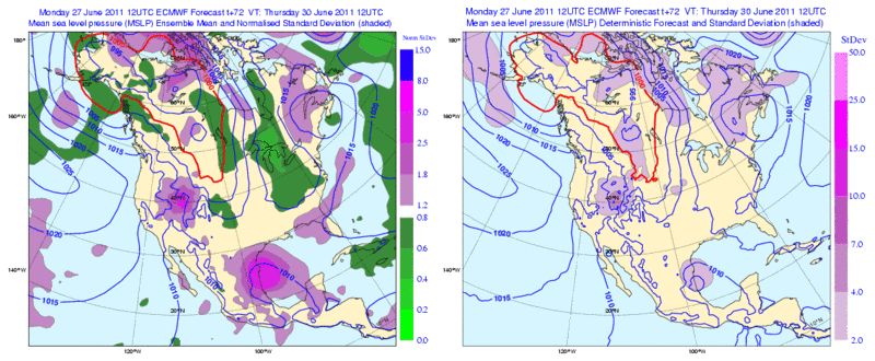
12zECMWF Ensembles are a tad further north with the low than the operational run.
0 likes
The following post is NOT an official forecast and should not be used as such. It is just the opinion of the poster and may or may not be backed by sound meteorological data. It is NOT endorsed by any professional institution including storm2k.org For Official Information please refer to the NHC and NWS products.
-
cycloneye
- Admin
- Posts: 149426
- Age: 69
- Joined: Thu Oct 10, 2002 10:54 am
- Location: San Juan, Puerto Rico
Re: ATL: INVEST 95L - Discussion
Up to 50%
TROPICAL WEATHER OUTLOOK
NWS NATIONAL HURRICANE CENTER MIAMI FL
800 PM EDT MON JUN 27 2011
FOR THE NORTH ATLANTIC...CARIBBEAN SEA AND THE GULF OF MEXICO...
SATELLITE PICTURES AND SURFACE OBSERVATIONS SUGGEST THAT THE BROAD
AREA OF LOW PRESSURE OVER THE EASTERN BAY OF CAMPECHE IS GRADUALLY
BECOMING BETTER DEFINED. ALTHOUGH UPPER-LEVEL WINDS ARE NOT
CURRENTLY CONDUCIVE FOR SIGNIFICANT DEVELOPMENT...THESE WINDS ARE
FORECAST TO BECOME MORE FAVORABLE DURING THE NEXT DAY OR SO. THERE
IS A MEDIUM CHANCE...50 PERCENT...OF THIS SYSTEM BECOMING A
TROPICAL CYCLONE DURING THE NEXT 48 HOURS AS IT MOVES SLOWLY
WEST-NORTHWESTWARD. AN AIR FORCE RESERVE UNIT HURRICANE HUNTER
PLANE IS SCHEDULED TO INVESTIGATE THE AREA TUESDAY AFTERNOON...IF
NECESSARY. REGARDLESS OF DEVELOPMENT...LOCALLY HEAVY RAINS AND
GUSTY WINDS ARE POSSIBLE OVER PORTIONS OF THE YUCATAN PENINSULA AND
SOUTHEASTERN MEXICO TONIGHT. THESE RAINS AND WINDS WILL GRADUALLY
SPREAD WESTWARD INTO NORTHEASTERN MEXICO DURING THE NEXT DAY OR
TWO.
ELSEWHERE...TROPICAL CYCLONE FORMATION IS NOT EXPECTED DURING THE
NEXT 48 HOURS.
$$
FORECASTER KIMBERLAIN/STEWART
0 likes
Visit the Caribbean-Central America Weather Thread where you can find at first post web cams,radars
and observations from Caribbean basin members Click Here
and observations from Caribbean basin members Click Here


-
MGC

- S2K Supporter
- Posts: 5940
- Joined: Sun Mar 23, 2003 9:05 pm
- Location: Pass Christian MS, or what is left.
Re: ATL: INVEST 95L - Discussion
50%????
Just don't see it....too much shear and after staring at a visable loop could not see a circulation. Bet those north winds are seabreezed induced like 57 said.......MGC
Just don't see it....too much shear and after staring at a visable loop could not see a circulation. Bet those north winds are seabreezed induced like 57 said.......MGC
0 likes
-
HURAKAN

- Professional-Met

- Posts: 46084
- Age: 39
- Joined: Thu May 20, 2004 4:34 pm
- Location: Key West, FL
- Contact:
Re:
NDG wrote:I agree with raising chances up to 50%, low pressure center starting to come together a little better just NE of Ciudad del Carmen, where pressure is now down to 1005mb.
The barometric pressure at Ciudad del Carmen has been oscillating between 1005 and 1009 mb for the past 2 days.
link: http://www.wunderground.com/history/air ... atename=NA
0 likes
Who is online
Users browsing this forum: No registered users and 10 guests