ATL: MARIA - Post-Tropical - Discussion

Moderator: S2k Moderators

Message
Author
ozonepete
Professional-Met
Professional-Met
Posts: 4743
Joined: Mon Sep 07, 2009 3:23 pm
Location: From Ozone Park, NYC / Now in Brooklyn, NY

Re: ATL: MARIA - Tropical Storm - Discussion

#2121 Postby ozonepete » Sun Sep 11, 2011 4:18 am

I understand. :)
I just don't like that heavy convective band moving towards them from the east-southeast and the fact that the southwestern side of the CDC is expanding towards them as well. If convection fills in between them they will get a heck of a lot more rain than was forecast.

Image
0 likes   

User avatar
AJC3
Admin
Admin
Posts: 3999
Age: 61
Joined: Tue Aug 31, 2004 7:04 pm
Location: Ballston Spa, New York
Contact:

Re: ATL: MARIA - Tropical Storm - Discussion

#2122 Postby AJC3 » Sun Sep 11, 2011 4:23 am

ozonepete wrote:I understand. :)
I just don't like that heavy convective band moving towards them from the east-southeast and the fact that the southwestern side of the CDC is expanding towards them as well. If convection fills in between them they will get a heck of a lot more rain than was forecast.

Image


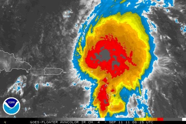
True, though if you look at radar, you'll see that is mostly the cirrostratus canopy. Sure, that will be something else they to keep an eye on, and there is a Flood Watch in effect, so as you mentioned, they'll need to be wary of that threat as well.
0 likes   

User avatar
Gustywind
Category 5
Category 5
Posts: 12334
Joined: Mon Sep 03, 2007 7:29 am
Location: Baie-Mahault, GUADELOUPE

#2123 Postby Gustywind » Sun Sep 11, 2011 5:17 am

Light rain, small gusts but numerours lightnings are reaching my area since 5 minutes.
0 likes   

ozonepete
Professional-Met
Professional-Met
Posts: 4743
Joined: Mon Sep 07, 2009 3:23 pm
Location: From Ozone Park, NYC / Now in Brooklyn, NY

Re:

#2124 Postby ozonepete » Sun Sep 11, 2011 5:22 am

Gustywind wrote:Light rain, small gusts but numerours lightnings are reaching my area since 5 minutes.


OK, hang in my friend. There could be some pretty good gusts coming thru in the next few hours.
0 likes   

User avatar
Gustywind
Category 5
Category 5
Posts: 12334
Joined: Mon Sep 03, 2007 7:29 am
Location: Baie-Mahault, GUADELOUPE

#2125 Postby Gustywind » Sun Sep 11, 2011 5:27 am

VIGIL OF ARMS FOR MARIA
:rarrow: http://www.microsofttranslator.com/bv.a ... 138066.php

V.D. France-Antilles Guadeloupe10.09.2011

In the imminence of the cyclonic phenomenon, fishermen have taken their responsibilities, putting their boats to safety, as here to Deshaies. (Dominique Chomereau-Lamotte)

Guadeloupe, saved for years, has found its reflexes. Vigil of arms until Maria.

For years it had not known it: he must go back to 1995 to return these same conditions, those announced cyclonic phenomenon which it is certain that he will attack us.

After 16 years interspersed by a few rare alerts, reflexes, but not are not dull. It was found Friday: while the storm was still several hundred kilometres, all of the precautions was arrested.

The decision, announced in the morning to close schools at noon, certainly caused major traffic jams that the usual caps of midday: 13 hours, the pointoise metropolitan road system was "saturated". But it was wise: Prefecture avoided the formation of major traffic jams in the evening, weather conditions would deteriorate greatly.

6 to 9 metres of hollow

Meanwhile, fishermen took their responsibilities (read below). As early as the early morning, especially in the more exposed fishing ports, saw the ballet returning boats loaded with traps, before be towed out of the water.

Precautionary principle requires, roads of Guadeloupe, as early as noon, announced the closure of the road crossing at 19 hours. For their part, the firefighters (read also) have strengthened teams and a State of devices.

During this time, Maria continued to upset the forecasters by his mood swings. The trajectory announced by specialized sites has continued to evolve, the centre being announced in the morning, to pass on the Salt River, and then, at noon, to pass on the Basse-Terre, before to be expected, at 5 p.m., on the great earth. This upwelling of Maria is rather pleased, the bulk of the winds being North of the phenomenon. The storm, also slowed, which is often a sign of strengthening.

At the time where we loop, last weather France bulletin indicated a passage of the storm on the Guadeloupe between 22 and 3 hours. Already observed maximum troughs were of 6 metres, announced wind gusts which may exceed 100 km/h. But the archipelago remained in orange vigilance.


-Fishermen at sentencing

Friday morning, the fishermen pulled their boats, after having recovered at sea what they could of their fishing gear.

Friday morning, fishermen, including those most exposed ports, set out the boats. Logical precautionary: the weather announced hollow of 5 to 6 metres, with possible records to 8 metres. When waves of this magnitude sweep, no line is long. Particularly to banana...

Because banana, could not call it a port. Just anchorage, large open on the wide, and deep 60 cm maximum at low tide. This was the case yesterday morning and fishermen struggling to get out the boat. "No water under the hull, it is really too hard," plague Patrick Jabot, boss fisherman of his State. But it is really not question to let boats to the water: in view of the configuration of the berth? - opened on the coast on one side, mouth of one River on the other - small basin is likely to become, to the passage of the storm, a real maelstrom. The problem is recurring: "I going well awake nights," says Patrick Jabot. Because as soon as the wind blows and a little sea between, I am concerned for my boat. »

As early as Friday morning, boaters and fishermen were boats to safety.

A dam and a RIP rap

Obviously, the small fishing port - which houses yet patterns fishermen, young people in their great majority - 20 is not safe. The situation is known, professionals have denounced him, and a project exists. But since 6 years, he sleeps in a drawer or a shirt. "However, it does not ask the moon." A dam and a rock. Anchorages, it will take in care ourselves if necessary. This is not the money missing, is the will of the elected representatives. It has already blocked the road to be heard. All that has been obtained are promises... »

One day, perhaps. Friday, fishermen had something else in mind. Around 11 a.m., there was still some ships to return. "They will not delay." They went out they could of their traps. Now, with this story of the Chlordecone pollution, we are obliged to ask them more offshore. It takes more time, and more fuel... "With the swell expected, the number of traps and nets will disappear. The invoice will be salted.


-Preparations at Pointe-à-Pitre marina

No safe pandemonium, Friday, 11-13 hours at the gullet/Pointe-à-Pitre marina: the largest of the Caribbean in terms of concentration (1 200 boats). Philippe Chevallier, Director, stated: "For we, boats taking water, is not very serious." And the sea at marina level will not change because it rained. Still, rain can fill the boats which are open, and that the bilge pumps would not work. However, the impact wind, the marina, much more than showers...

We réamarrons improperly moored boats. We are entering in contact with the owners asking them to strengthen their lines of double them, triple them, and put tires on the sides of the boats to protect. »

The passage in red, vigilance was fear the arrival of additional boats. "Those who come with old boats, little maintained are often anywhere, among others, who are already well moored.". They represent risks for moored vessels. There is also careless owners who take no precautions. Taking their boats and is outside the marina, to avoid that they damage other vessels already landed, as this could cause a collective risk. »

Yesterday, owners, not at all worried, came to tend the rope of their boat, to keep well away from the wharf, and put tires to protect a possible friction.

Philippe Chevallier giving some instructions to the owner of a boat moored at the marina of peak-to-Pitre/Le Gosier. (Roberto Birhus)


-Relief
Nearly 200 firefighters mobilized

Yesterday morning, colonel Gilles Bazir, Director of the departmental fire and rescue (Sdis) announced the building of the relief devices. "It checks that all centres are the most of their strength." Specialized teams are mobilized, aquatic rescue and recognition and intervention in the perilous environment (Grimp) group. They are ready to answer for floods or blocked persons. »

Firefighters will be represented in different PCs. "On a personal place in the Prefecture, in the centre of defence (COD)." It puts at disposal of the communal PC wishing a firefighter. In the most threatened areas, he will be physically present. In others it will be a telephone referent to a Council, assistance. »

But mostly, the Sdis will activate its own operational centre, Codis, which will strengthen the treatment of the alert (CTA) Centre. "They are four in the CTA.". It brought additional two operators and an officer. Which will increase the capacity of response to the 18. "The Codis should be activated as early as 16 hours, Friday.

In total, is not less than 200 firefighters, professional and voluntary, that will be mobilized for the passage of Maria.

Mounted police and police on alert

As early as yesterday afternoon, the force was mobilized. Patrols recognize the axes to uncover possible difficulties. Special means were put on alert, loans to be operated to identify directions and wear relief (helicopter, 4 x 4, armoured wheeled...). "Especially for the after storm", indicated on command of the force, ready to rise in power in terms of staff if necessary. The intervention platoons (GPI) Group was in early warning. Idem for the intervention of the national police (GIPN) group. Police also prepared in the event of the passage in red alert level. In this case, the patrols increased to encourage onlookers to reach the shelters or their home - by force if necessary - and to avoid looting.

Safety advice

With the approach of the Storm Maria, colonel Gilles Bazir, Director of the departmental fire and rescue (Sdis) reiterates precautionary. "Although caulking homes, do not leave objects which swept away by the wind, could be used as projectiles.". Listen to the media to follow the evolution of the weather. Follow the instructions of the Prefecture... "It also emphasizes the proper use of generators in the event of power failure:"Attention by manipulating." Do not turn it on without well verified their proper functioning. Does not meet groups of gasoline when they turn. It has already given it. Must stop the Group and to ensure that there is no spark in the filling of gasoline. "Attention finally to candles. "Loose candles, it falls and makes fire."


-ANTHONY GRENOT, BOSS FISHERMAN

People believe that the fishermen of banana well earn their life, because we have the trailer and 4 x 4. But we we are indebted to buy such equipment without which, here, it would lose our boats.


-Shuttle interisland
The Guadeloupéns have reconstructed their stocks of mineral water, in preparation for the arrival of Maria. (D. V.-L.)

Until further notice, the service of the Holy is interrupted.

The islands of the Express Company stops its rotation until new order and will make a decision based on the evolution of the phenomenon, this Sunday.


-Roads

The crossing closed preventively
Friday noon, roads of Guadeloupe announced the preventive closure of the road crossing from 19 hours this Friday. If the weather conditions, it could reopen around 6 or 7 p.m. Saturday, intensity of the phenomenon.

Roads of Guadeloupe on the bridge

Friday, until the rains arrive, Guadeloupe road teams toured to verify that sanitation grids operated and were not blocked. The Director of the structure, Jean-Gabriel Quillin, indicated that 6 hours starting Saturday, teams on call-180 without effective coaching - would be on the bridge, ready to intervene as soon as weather conditions allow. It will be found possible damage (trees or poles down, roads flooded, landslides...) and to the axes in circulation as quickly as possible.
0 likes   

User avatar
Gustywind
Category 5
Category 5
Posts: 12334
Joined: Mon Sep 03, 2007 7:29 am
Location: Baie-Mahault, GUADELOUPE

#2126 Postby Gustywind » Sun Sep 11, 2011 5:30 am

000
WTNT34 KNHC 110837
TCPAT4

BULLETIN
TROPICAL STORM MARIA ADVISORY NUMBER 19
NWS NATIONAL HURRICANE CENTER MIAMI FL AL142011
500 AM AST SUN SEP 11 2011

...MARIA EXPECTED TO MOVE GRADUALLY AWAY FROM THE EXTREME
NORTHEASTERN CARIBBEAN TODAY...


SUMMARY OF 500 AM AST...0900 UTC...INFORMATION
----------------------------------------------
LOCATION...19.0N 63.7W
ABOUT 95 MI...150 KM ENE OF ST. THOMAS
ABOUT 160 MI...260 KM ENE OF SAN JUAN PUERTO RICO
MAXIMUM SUSTAINED WINDS...60 MPH...95 KM/H
PRESENT MOVEMENT...NW OR 315 DEGREES AT 13 MPH...20 KM/H
MINIMUM CENTRAL PRESSURE...1004 MB...29.65 INCHES
0 likes   

User avatar
Gustywind
Category 5
Category 5
Posts: 12334
Joined: Mon Sep 03, 2007 7:29 am
Location: Baie-Mahault, GUADELOUPE

Re: Re:

#2127 Postby Gustywind » Sun Sep 11, 2011 5:37 am

ozonepete wrote:
Gustywind wrote:Light rain, small gusts but numerours lightnings are reaching my area since 5 minutes.


OK, hang in my friend. There could be some pretty good gusts coming thru in the next few hours.

Thanks :) you're right, looks like we should deal with other episodes of rain, tstorms and gustywinds.
0 likes   

User avatar
Gustywind
Category 5
Category 5
Posts: 12334
Joined: Mon Sep 03, 2007 7:29 am
Location: Baie-Mahault, GUADELOUPE

#2128 Postby Gustywind » Sun Sep 11, 2011 5:42 am

Loop of TS Maria moving gradually away :) from the NE Carib Islands...

Image
0 likes   

User avatar
cycloneye
Admin
Admin
Posts: 145285
Age: 68
Joined: Thu Oct 10, 2002 10:54 am
Location: San Juan, Puerto Rico

Re: ATL: MARIA - Tropical Storm - Discussion

#2129 Postby cycloneye » Sun Sep 11, 2011 5:51 am

Good morning.

So far in San Juan only a few rapid moving showers have moved thru during the past few hours. Also,the wind direction has been between NNE to NE,but that will change with time as Maria moves more to the north of here. The Flash Flood Watch has been trimmed to only the Eastern part of the island.

Code: Select all

6 AM (10) Sep 11 82.0 (27.8) 75.0 (23.9) 29.85 (1010) NE 9 
 5 AM (9) Sep 11 82.0 (27.8) 73.9 (23.3) 29.84 (1010) NNE 9 
 4 AM (8) Sep 11 82.0 (27.8) 75.0 (23.9) 29.84 (1010) NE 10 
 3 AM (7) Sep 11 82.0 (27.8) 73.9 (23.3) 29.84 (1010) NE 10 
 2 AM (6) Sep 11 81.0 (27.2) 75.0 (23.9) 29.86 (1011) NNE 17 
 1 AM (5) Sep 11 82.0 (27.8) 75.0 (23.9) 29.87 (1011) NNE 14
0 likes   
Visit the Caribbean-Central America Weather Thread where you can find at first post web cams,radars
and observations from Caribbean basin members Click Here

User avatar
Gustywind
Category 5
Category 5
Posts: 12334
Joined: Mon Sep 03, 2007 7:29 am
Location: Baie-Mahault, GUADELOUPE

#2130 Postby Gustywind » Sun Sep 11, 2011 6:33 am

Given the latest news of our local radio RCI... a large total blackout has occured in Martinica between 11 p.m. and 6 a.m. Thunderstorms impacts were very violent! Power has returned but not in all homes.
0 likes   

User avatar
Gustywind
Category 5
Category 5
Posts: 12334
Joined: Mon Sep 03, 2007 7:29 am
Location: Baie-Mahault, GUADELOUPE

#2131 Postby Gustywind » Sun Sep 11, 2011 7:15 am

Electric Light show amazing!
:rarrow: http://stormcarib.com/reports/current/dominica.shtml

•By Lisette Stevens <jaco.lass at gmail.com>
•Date: Sun, 11 Sep 2011 03:51:56 -0700

What an amazing evening Maria entertained us while we had dinner with some friends on our deck! We have the cliffs of the Layou river as part of our view from our deck and beyond the cliffs is the ocean; well last night the lightning over the ocean gave us the most amazing show of different colours as the sheet lightning lit up the sky time and time again! I am usually scared of lightning but it was not close enough to frighten me - it was like the best fireworks show we had ever seen especially here in Dominica! When we finally got to bed there was a huge roar and crash of thunder closely followed by lightning very close to us. Off went the electricity, I stuck my head under the covers feeling cozy and safe. The thunder and lightning lasted until about 2.30 a.m. We had some rain but nothing much. Maria has finally marched on but will have a lasting effect as the slow dancer not getting her steps together.
0 likes   

User avatar
cycloneye
Admin
Admin
Posts: 145285
Age: 68
Joined: Thu Oct 10, 2002 10:54 am
Location: San Juan, Puerto Rico

Re: ATL: MARIA - Recon Discussion

#2132 Postby cycloneye » Sun Sep 11, 2011 7:17 am

I am going to church so who wants to post the obs from the current mission?
0 likes   
Visit the Caribbean-Central America Weather Thread where you can find at first post web cams,radars
and observations from Caribbean basin members Click Here

Jimsot
Tropical Storm
Tropical Storm
Posts: 157
Age: 77
Joined: Sat Sep 09, 2006 1:31 pm
Location: Upstate SC

Re: ATL: MARIA - Tropical Storm - Discussion

#2133 Postby Jimsot » Sun Sep 11, 2011 7:45 am

Maria passed quite close to the Eastern tip of Anguilla last night and it was not much of an event. Later on however (after midnight) it got quite 'breezy' with moderate rain showers. It was noisy enough to make sleeping a problem. This weather continued all night. Looks like we are just about to exit the bad weather ever so slowly.
0 likes   

User avatar
Gustywind
Category 5
Category 5
Posts: 12334
Joined: Mon Sep 03, 2007 7:29 am
Location: Baie-Mahault, GUADELOUPE

#2134 Postby Gustywind » Sun Sep 11, 2011 7:47 am

Latest weather forecast from Guadeloupe...
:rarrow: http://www.microsofttranslator.com/bv.a ... h_guad.php

The time for the next few hours on the Guadeloupe

Weather-France Guadeloupe Hello!
0645 AM the level of vigilance is: yellow for heavy rains / storms and dangerous sea.
The storm tropical Maria continues its trajectory towards the Northwest at 20 km/h.
In this early in the morning, the sky is covered on a good part of our islands and showers are still many, becoming sometimes stormy. In large funds of Saint-Anne, cumulation of precipitation over the past 6 hours is an average of 60 mm of water.
Over the next three hours, little change to wait; time will remain moist and unstable, with alternating thinned brief and many cloudy carriers of showers, which can be locally stormy.
These observations and immediate evolution will be updated to 0945 AM.
0 likes   

User avatar
Gustywind
Category 5
Category 5
Posts: 12334
Joined: Mon Sep 03, 2007 7:29 am
Location: Baie-Mahault, GUADELOUPE

#2135 Postby Gustywind » Sun Sep 11, 2011 7:59 am

Latest on the poweroutages in Martinica given our local radio RCI.
Only 25% of the electrical network is restored.
0 likes   

User avatar
Macrocane
Category 5
Category 5
Posts: 4218
Age: 36
Joined: Sun May 24, 2009 5:35 pm
Location: El Salvador

Re: ATL: MARIA - Recon

#2136 Postby Macrocane » Sun Sep 11, 2011 8:35 am

000
URNT15 KNHC 111328
AF308 0614A MARIA HDOB 19 20110911
131830 2053N 06546W 8430 01596 //// +160 //// 082027 028 026 002 01
131900 2052N 06544W 8431 01595 //// +160 //// 083026 027 033 001 01
131930 2052N 06542W 8433 01590 //// +156 //// 079026 027 031 002 05
132000 2050N 06542W 8427 01597 //// +155 //// 076026 027 029 001 05
132030 2049N 06541W 8429 01594 //// +154 //// 080029 030 030 002 05
132100 2047N 06539W 8422 01602 //// +155 //// 084028 029 032 001 01
132130 2046N 06538W 8431 01596 //// +155 //// 080030 031 031 001 01
132200 2045N 06536W 8424 01602 //// +159 //// 078029 029 031 001 01
132230 2043N 06535W 8433 01593 //// +158 //// 076029 030 030 001 01
132300 2042N 06533W 8432 01595 //// +155 //// 078028 029 030 001 01
132330 2041N 06532W 8429 01596 //// +158 //// 079026 026 033 001 01
132400 2039N 06530W 8429 01596 //// +160 //// 076028 029 032 002 01
132430 2038N 06529W 8430 01595 //// +160 //// 077029 029 033 002 01
132500 2036N 06527W 8438 01586 //// +164 //// 075029 030 032 000 01
132530 2035N 06526W 8427 01594 //// +165 //// 074026 027 033 000 05
132600 2034N 06525W 8432 01586 //// +162 //// 076030 033 032 002 05
132630 2032N 06523W 8421 01601 //// +156 //// 080033 034 034 002 01
132700 2031N 06522W 8431 01591 //// +155 //// 082032 032 033 001 01
132730 2029N 06520W 8434 01589 //// +155 //// 083032 033 032 002 01
132800 2028N 06519W 8430 01591 //// +155 //// 078031 032 035 001 01
$$
;
0 likes   

User avatar
Macrocane
Category 5
Category 5
Posts: 4218
Age: 36
Joined: Sun May 24, 2009 5:35 pm
Location: El Salvador

Re: ATL: MARIA - Recon

#2137 Postby Macrocane » Sun Sep 11, 2011 8:41 am

000
URNT15 KNHC 111338
AF308 0614A MARIA HDOB 20 20110911
132830 2026N 06517W 8420 01602 //// +157 //// 080031 031 035 000 01
132900 2025N 06516W 8429 01593 //// +160 //// 078029 030 036 000 01
132930 2023N 06514W 8431 01590 //// +160 //// 076028 028 036 001 01
133000 2022N 06512W 8431 01590 //// +160 //// 080027 028 036 000 01
133030 2020N 06511W 8428 01591 //// +161 //// 080027 027 036 001 05
133100 2019N 06509W 8426 01593 //// +164 //// 078027 028 034 003 05
133130 2017N 06508W 8429 01589 //// +165 //// 076027 028 034 001 01
133200 2015N 06507W 8430 01586 //// +168 //// 080027 028 034 002 05
133230 2013N 06505W 8437 01582 //// +172 //// 086029 031 036 001 01
133300 2012N 06504W 8438 01567 //// +162 //// 077031 033 039 000 01
133330 2011N 06503W 8414 01594 //// +168 //// 084029 029 036 001 01
133400 2009N 06501W 8423 01589 //// +174 //// 089029 030 038 002 01
133430 2008N 06500W 8429 01583 //// +177 //// 085029 030 036 001 05
133500 2006N 06459W 8428 01583 //// +178 //// 078029 029 037 001 01
133530 2004N 06458W 8429 01582 //// +178 //// 077030 031 037 001 01
133600 2002N 06457W 8430 01577 //// +171 //// 079029 030 038 001 01
133630 2000N 06456W 8428 01578 //// +173 //// 072029 030 039 000 01
133700 1958N 06455W 8431 01573 //// +171 //// 069028 030 036 001 01
133730 1956N 06454W 8428 01575 //// +179 //// 063025 025 036 000 01
133800 1954N 06453W 8431 01572 //// +179 //// 063027 028 037 000 01
$$
;
0 likes   

User avatar
Macrocane
Category 5
Category 5
Posts: 4218
Age: 36
Joined: Sun May 24, 2009 5:35 pm
Location: El Salvador

Re: ATL: MARIA - Recon

#2138 Postby Macrocane » Sun Sep 11, 2011 8:50 am

000
URNT15 KNHC 111348
AF308 0614A MARIA HDOB 21 20110911
133830 1951N 06452W 8431 01573 //// +183 //// 065030 031 037 001 01
133900 1949N 06451W 8439 01561 //// +186 //// 065031 032 038 000 01
133930 1948N 06450W 8432 01563 //// +186 //// 066032 032 039 001 01
134000 1946N 06450W 8425 01569 //// +186 //// 067031 032 042 000 01
134030 1944N 06449W 8433 01560 //// +190 //// 065028 029 039 001 01
134100 1943N 06448W 8427 01567 //// +190 //// 063026 027 039 001 01
134130 1941N 06448W 8429 01563 //// +190 //// 060026 027 039 003 05
134200 1939N 06447W 8428 01566 //// +190 //// 062027 027 040 001 01
134230 1938N 06446W 8433 01558 //// +190 //// 061026 027 039 000 01
134300 1936N 06445W 8428 01563 //// +189 //// 062025 026 039 001 01
134330 1934N 06444W 8426 01563 //// +190 //// 062027 027 039 001 01
134400 1933N 06443W 8429 01562 //// +190 //// 062026 026 038 000 01
134430 1931N 06442W 8429 01560 //// +186 //// 059024 025 038 002 01
134500 1929N 06441W 8431 01558 //// +186 //// 055021 023 036 000 05
134530 1928N 06440W 8429 01560 //// +185 //// 049018 019 037 001 05
134600 1927N 06439W 8432 01557 //// +180 //// 058016 017 035 000 01
134630 1925N 06438W 8429 01558 //// +180 //// 066018 018 035 000 05
134700 1923N 06437W 8429 01561 //// +180 //// 062019 019 034 001 01
134730 1922N 06436W 8431 01558 //// +180 //// 059015 017 034 000 01
134800 1920N 06435W 8429 01558 //// +176 //// 059014 014 033 000 05
$$
;
0 likes   

Caribwxgirl
S2K Supporter
S2K Supporter
Posts: 287
Joined: Mon Aug 15, 2011 7:25 pm
Location: Budapest, Hungary (from Kingston, Jamaica)

#2139 Postby Caribwxgirl » Sun Sep 11, 2011 8:59 am

Oh dear hope its all restored soon. Power outages are no fun!
0 likes   
Personal Forecast Disclaimer:
The posts in this forum are NOT official forecast. They are just the opinion of the poster and may or may not be backed by sound meteorological data. They are NOT endorsed by any professional institutions or storm2k.org. For official information refer to the NHC and NWS products.

User avatar
Macrocane
Category 5
Category 5
Posts: 4218
Age: 36
Joined: Sun May 24, 2009 5:35 pm
Location: El Salvador

Re: ATL: MARIA - Recon

#2140 Postby Macrocane » Sun Sep 11, 2011 9:03 am

000
URNT15 KNHC 111358
AF308 0614A MARIA HDOB 22 20110911
134830 1919N 06434W 8429 01558 //// +180 //// 059012 013 031 000 01
134900 1917N 06433W 8429 01558 //// +179 //// 053013 013 030 001 01
134930 1915N 06432W 8430 01557 //// +178 //// 057011 013 030 000 01
135000 1914N 06431W 8430 01557 //// +179 //// 067009 010 030 000 01
135030 1912N 06430W 8429 01557 //// +180 //// 069007 008 030 001 01
135100 1911N 06429W 8430 01556 //// +180 //// 075009 010 031 001 05
135130 1909N 06429W 8428 01560 //// +180 //// 073007 008 031 000 01
135200 1907N 06428W 8429 01557 //// +185 //// 093005 006 031 000 01
135230 1905N 06428W 8433 01555 //// +186 //// 105006 008 031 000 05
135300 1904N 06427W 8428 01560 //// +194 //// 169004 006 031 001 01
135330 1902N 06427W 8429 01557 //// +189 //// 164008 009 031 000 01
135400 1900N 06427W 8430 01558 //// +193 //// 162009 009 028 001 01
135430 1858N 06427W 8428 01560 //// +190 //// 165010 010 025 001 01
135500 1857N 06426W 8428 01561 //// +190 //// 168012 013 025 000 01
135530 1855N 06426W 8435 01549 //// +193 //// 155012 012 /// /// 05
135600 1854N 06428W 8433 01556 //// +195 //// 130013 013 023 001 05
135630 1854N 06430W 8433 01555 //// +195 //// 121011 012 022 000 05
135700 1853N 06432W 8429 01558 //// +195 //// 117009 009 023 000 05
135730 1851N 06432W 8430 01558 //// +197 //// 118008 008 023 000 01
135800 1850N 06433W 8429 01560 //// +191 //// 123005 007 024 000 05
$$
0 likes   


Return to “2011”

Who is online

Users browsing this forum: No registered users and 9 guests