ATL: IRENE - Models
Moderator: S2k Moderators
-
HURRICANELONNY
- Category 5

- Posts: 1392
- Joined: Wed May 07, 2003 6:48 am
- Location: HOLLYWOOD.FL
Re: ATL: IRENE - Models
Mornin all. I see some of the models are flip flopping. That's normal this far out. Will it feel the 1st trough or not. Who knows. Trends are our friend or enemy. Before I went to bed. TWC had. Not if. But when Savanah Ga. will get hit. That's also plausible. So nobody is out of the woods yet. 
Last edited by HURRICANELONNY on Sun Aug 21, 2011 8:28 am, edited 1 time in total.
0 likes
hurricanelonny

-
Dean4Storms
- S2K Supporter

- Posts: 6358
- Age: 63
- Joined: Sun Aug 31, 2003 1:01 pm
- Location: Miramar Bch. FL
Sure looks like the development sooner and further north in latitude made all the difference in the world with the models having Irene feel the weakness and turn more sharply into it.
I believe though this scenario could change if Irene fails to deepen much more due to either the dry air or hitting Hispaniola directly. If she were to be weakened or remains weak she could make a less dramatic NW turn and still end up in the SE GOM!
I believe though this scenario could change if Irene fails to deepen much more due to either the dry air or hitting Hispaniola directly. If she were to be weakened or remains weak she could make a less dramatic NW turn and still end up in the SE GOM!
0 likes
-
hurricanedude

- Military Member

- Posts: 1856
- Joined: Tue Oct 08, 2002 9:54 am
- Location: Virginia Beach, Virginia
- Contact:
Re: ATL: IRENE - Models
Could JB be right? he said a week ago that this storm would hit the Carolinas...if the trend continues, he could be right
0 likes

A closer look at the 12z early tropical models:
They are starting to gather on the east coast of FL or just offshore. One negative thing to this that it will spend more time over water and gather more strength before entually moving onshore whether is in central or NE FL or points north towards GA or the Carolinas.
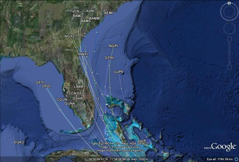
The 12z TVCN just barely moved to the right, it has moved from landfall near Homestead to Miami Beach from its previous run, so I expect the NHC to not move much its track on their next advisory.
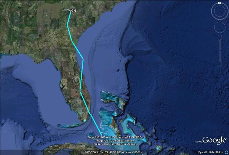
They are starting to gather on the east coast of FL or just offshore. One negative thing to this that it will spend more time over water and gather more strength before entually moving onshore whether is in central or NE FL or points north towards GA or the Carolinas.
The 12z TVCN just barely moved to the right, it has moved from landfall near Homestead to Miami Beach from its previous run, so I expect the NHC to not move much its track on their next advisory.
0 likes
Re:
Dean4Storms wrote:Sure looks like the development sooner and further north in latitude made all the difference in the world with the models having Irene feel the weakness and turn more sharply into it.
I believe though this scenario could change if Irene fails to deepen much more due to either the dry air or hitting Hispaniola directly. If she were to be weakened or remains weak she could make a less dramatic NW turn and still end up in the SE GOM!
This is reminding me a lot of Floyd in 1999, without the CAT 5 factored in. Track trending and forecasting is very similar, though.
I'd be real concerned if I lived in Wilmington NC (AKA "the Chin") right now.
0 likes
-
Aric Dunn
- Category 5
- Posts: 21238
- Age: 43
- Joined: Sun Sep 19, 2004 9:58 pm
- Location: Ready for the Chase.
- Contact:
The best solution so far and has been the most consistent is the euro. it turns irene NNW into the weakness but no recurve out to sea or the carolina because there is no digging trough just the weakness and the ridge to the east and west.
Last edited by Aric Dunn on Sun Aug 21, 2011 8:35 am, edited 1 time in total.
0 likes
Note: If I make a post that is brief. Please refer back to previous posts for the analysis or reasoning. I do not re-write/qoute what my initial post said each time.
If there is nothing before... then just ask
Space & Atmospheric Physicist, Embry-Riddle Aeronautical University,
I believe the sky is falling...
If there is nothing before... then just ask
Space & Atmospheric Physicist, Embry-Riddle Aeronautical University,
I believe the sky is falling...
-
Dean4Storms
- S2K Supporter
- Posts: 6358
- Age: 63
- Joined: Sun Aug 31, 2003 1:01 pm
- Location: Miramar Bch. FL
Re: ATL: IRENE - Models
tolakram wrote:Stop copying images on every reply and no one is attacking anyone.
Yes KORY did, he called him a Troller for stating his opinion.
0 likes
-
Miami Storm Tracker

- Category 4

- Posts: 916
- Age: 68
- Joined: Sun Jun 13, 2010 10:12 pm
- Location: Key Largo, Fla.
- Contact:
Re: ATL: IRENE - Models
I have to disagree,
I would not normally reply to something like that, but it did appear he was or should have used a different term in his reply it it was not intended to be.
I would not normally reply to something like that, but it did appear he was or should have used a different term in his reply it it was not intended to be.
0 likes
-
UpTheCreek

- Category 1

- Posts: 397
- Age: 62
- Joined: Tue Aug 31, 2004 5:28 pm
- Location: Vassalboro, Maine
Re: ATL: IRENE - Models
hurricanedude wrote:Could JB be right? he said a week ago that this storm would hit the Carolinas...if the trend continues, he could be right
Did JB say that? Phew, now I'm a bit relieved!
0 likes
-
hurricanedude
- Military Member
- Posts: 1856
- Joined: Tue Oct 08, 2002 9:54 am
- Location: Virginia Beach, Virginia
- Contact:
Re:
Aric Dunn wrote:The best solution so far and has been the most consistent is the euro. it turn irene NWW into the weakness but no recurve out to sea or the carolina because there is no digging trough just the weakness and the ridge to the east and west.
No doubt about it, but I am fairly impressed with the GFS for the last 24 hrs or so, it has been keeping up with the Euro.
Are we finally seeing the "better" improved GFS finally?
0 likes
-
hurricanedude
- Military Member
- Posts: 1856
- Joined: Tue Oct 08, 2002 9:54 am
- Location: Virginia Beach, Virginia
- Contact:
Re: ATL: IRENE - Models
LOL i wouldnt be to Relieved....this thing could be a big deal from Fl north to Chesapeake Bay
0 likes
-
Aric Dunn
- Category 5
- Posts: 21238
- Age: 43
- Joined: Sun Sep 19, 2004 9:58 pm
- Location: Ready for the Chase.
- Contact:
Re: ATL: IRENE - Models
hurricanedude wrote:Hey Aric you dont think the Carolinas are at play?
not as of right now. nothing to turn it NNE. but it could change.
0 likes
Note: If I make a post that is brief. Please refer back to previous posts for the analysis or reasoning. I do not re-write/qoute what my initial post said each time.
If there is nothing before... then just ask
Space & Atmospheric Physicist, Embry-Riddle Aeronautical University,
I believe the sky is falling...
If there is nothing before... then just ask
Space & Atmospheric Physicist, Embry-Riddle Aeronautical University,
I believe the sky is falling...
-
hurricanedude
- Military Member
- Posts: 1856
- Joined: Tue Oct 08, 2002 9:54 am
- Location: Virginia Beach, Virginia
- Contact:
-
WeatherEmperor
- S2K Supporter
- Posts: 4806
- Age: 42
- Joined: Thu Sep 04, 2003 2:54 pm
- Location: South Florida
Re: ATL: IRENE - Models
Aric Dunn wrote:hurricanedude wrote:Hey Aric you dont think the Carolinas are at play?
not as of right now. nothing to turn it NNE. but it could change.
Aric,
Just woke up and saw the models. I was hoping they would shift totally further east but they didn't really. Are you sure you don't see anything that could pull Irene more NE away from FL? If the models stay clustered pretty close to FL by the end of the day, I will get really worried
0 likes
-
TBCaneFreak

- Tropical Depression

- Posts: 69
- Joined: Thu Aug 18, 2011 6:23 pm
- Location: Trinity,FL
Re: ATL: IRENE - Models
Dean4Storms wrote:tolakram wrote:Stop copying images on every reply and no one is attacking anyone.
Yes KORY did, he called him a Troller for stating his opinion.
No issue..moving on...
BTW Artic I think your spot on, and that was my point...were not talking about a trof, were talking about finding the edge of the ridge...so there should be a sweeping right turn, not a stop, look both ways and hard right....
0 likes
Its impossible to see a problem, using the vision that created it..
-
Kory
- Tropical Storm

- Posts: 200
- Age: 30
- Joined: Tue Aug 02, 2011 11:32 am
- Location: New Orleans, Louisiana
Re: ATL: IRENE - Models
Aric Dunn wrote:hurricanedude wrote:Hey Aric you dont think the Carolinas are at play?
not as of right now. nothing to turn it NNE. but it could change.
What do you think about a turn just to the east of Florida and due north into SC? I certainly think that's plausible.
0 likes
-
plasticup
Re: ATL: IRENE - Models
The 06z GFS solution pretty much destroys Savannah. That city is really vulnerable and wouldn't survive a Cat3+ hit.
0 likes
Who is online
Users browsing this forum: No registered users and 22 guests