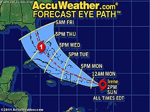
ATL: IRENE - Models

Moderator: S2k Moderators

Message
Author
User avatar
Rgv20
S2K Supporter
S2K Supporter
Posts: 2466
Age: 39
Joined: Wed Jan 05, 2011 5:42 pm
Location: Edinburg/McAllen Tx

Re: Re:

#2561 Postby Rgv20 » Sun Aug 21, 2011 2:11 pm

NDG wrote:
Rgv20 wrote:TVCN has the center of Irene 75miles east of Miami by 96hrs.....way to close for comfort.


Yeah, and the NHC's track will follow suit inching in closer to it, I don't think they want to move the track too far east just yet, it will give eastern FL a false sense of security at this point if they do so.


In my opinion it will be best for the NHC's track to still show a landfall in florida at least on the 5pm and 10pm track update.
0 likes   
The following post is NOT an official forecast and should not be used as such. It is just the opinion of the poster and may or may not be backed by sound meteorological data. It is NOT endorsed by any professional institution including storm2k.org For Official Information please refer to the NHC and NWS products.

User avatar
Bocadude85
Category 5
Category 5
Posts: 2991
Age: 38
Joined: Mon Apr 18, 2005 2:20 pm
Location: Honolulu,Hi

Re: Re:

#2562 Postby Bocadude85 » Sun Aug 21, 2011 2:12 pm

Rgv20 wrote:
KWT wrote:
Rgv20 wrote:TVCN has the center of Irene 75miles east of Miami by 96hrs.....way to close for comfort.


Thats certainly very close to land, far too close to discount a motion a little further west.


And about 45 miles on the closest approach to West Palm Beach.


Yes close enough to bring TS condtions to South Florida... lol 45 miles does not leave much room for error
0 likes   

jinftl
Category 5
Category 5
Posts: 4312
Joined: Tue Aug 31, 2004 4:47 pm
Location: fort lauderdale, fl

Re: ATL: IRENE - Models

#2563 Postby jinftl » Sun Aug 21, 2011 2:15 pm

From 11am to 2pm today, Irene reached the latitude forecast point that she wasn't supposed to reach until 11pm tonight....about 100 miles east of the forecast that came out just 3 hours earlier (17.5N). In 180 minutes, the actual position ended up being as far north but 100 miles east of where the NHC put her at by 11pm tonight.

Margin of error. It exists in the short-term. In the long term, it is all about the trends of the models and not the nitty gritty details. If the consensus of models showed a storm over florida with this mornings runs, and now they show tracks just east of florida, and then tomorrow morning, the models show tracks 150 miles east of florida, that is a trend of significance.
0 likes   

User avatar
ROCK
Category 5
Category 5
Posts: 9484
Age: 54
Joined: Tue Aug 17, 2004 7:30 am
Location: Kemah, Texas

Re:

#2564 Postby ROCK » Sun Aug 21, 2011 2:17 pm

OuterBanker wrote:Interesting, just ran cities overdue on weather channel last night. Of Course Savannah was one of them. It has been a while since Charleston too (a few were predicted to hit Charleston but hit NC instead). The overdue people will have a heyday. At least the models are.. still leaving us out of it so far.


TWC stating one particular area is overdue is sort of wierd...since no area is overdue in the true sense of the word as it relates to hurricanes....JMO...
0 likes   

User avatar
sunnyday
Category 5
Category 5
Posts: 1590
Joined: Thu Sep 04, 2003 8:16 pm

Re: ATL: IRENE - Models

#2565 Postby sunnyday » Sun Aug 21, 2011 2:17 pm

Looking much better for SE Fl, right? I always say that Florida looks like a sitting duck in the Atlantic, yet so many storm destined for the state manage to miss! Perhaps it dodges the bullet once again, huh? Time will tell. 8-) This is my opinion only--see the NHC site for accurate info.
0 likes   

plasticup

Re: Re:

#2566 Postby plasticup » Sun Aug 21, 2011 2:18 pm

ndale wrote:
OuterBanker wrote:Granted I've only checked a few pages back in this thread only. But I haven't seen any posting by Cycloneye. It looks like he's about to get nailed. Any word on conditions there?


He just posted at 2:04 in the discussion thread.

And the "Who is online" box at the bottom shows him being active. I'm sure he knows to stay safe!
0 likes   

breaking wind
Tropical Low
Tropical Low
Posts: 30
Joined: Sun Aug 15, 2010 7:53 pm
Location: Lakeland FL

Re: ATL: IRENE - Models

#2567 Postby breaking wind » Sun Aug 21, 2011 2:19 pm

I just dont see how Hispaniola doesnt have Irene as a visitor for a good bit, very bad news for them unfortunately. On a positive note, it won't dissipate Irene but should give it a pretty good black eye. I have no faith in any model until it passes that Island nation.
0 likes   

bamajammer4eva
Category 4
Category 4
Posts: 907
Joined: Sun Apr 18, 2010 3:21 am
Location: Ozark, AL

Re: ATL: IRENE - Models

#2568 Postby bamajammer4eva » Sun Aug 21, 2011 2:24 pm

Looks like Accuweather track is closer to the models than NHC.

Image
0 likes   

jinftl
Category 5
Category 5
Posts: 4312
Joined: Tue Aug 31, 2004 4:47 pm
Location: fort lauderdale, fl

Re: ATL: IRENE - Models

#2569 Postby jinftl » Sun Aug 21, 2011 2:24 pm

Agree, it is not like the troughs forecast to turn her more north are already in place and doing their magic on her track. Forecasting a system that will be turning....and not even factoring in the impact of a landmass like hispanola into that...is tricky and prone to error.

We thought Ike was heading for Miami less than 96 hours out.

I guess it is the difference between using model runs to derive your forecast vs. understanding what is happening in the environment that is causing the model runs and seeing if it is reasonable. Is there anything so concrete right now that 'seals the deal' that this will never make it west of 80W...or is it because the latest runs suggest it? If those model runs shift west tomorrow, do we start talking about a texas threat again?
Last edited by jinftl on Sun Aug 21, 2011 2:25 pm, edited 1 time in total.
0 likes   

emeraldislencguy
S2K Supporter
S2K Supporter
Posts: 207
Joined: Sun Aug 27, 2006 4:35 pm
Location: emerald isle nc
Contact:

Re: ATL: IRENE - Models

#2570 Postby emeraldislencguy » Sun Aug 21, 2011 2:25 pm

just saw some of the new models
it looks like it could be more of a threat to nc
i will definitely start paying attention
i really appreciate the remarks of the pro mets
yall keep up the good work
0 likes   

User avatar
SFLcane
S2K Supporter
S2K Supporter
Posts: 10163
Age: 47
Joined: Sat Jun 05, 2010 1:44 pm
Location: Lake Worth Florida

Re: ATL: IRENE - Models

#2571 Postby SFLcane » Sun Aug 21, 2011 2:26 pm

By Tuesday/Wednesday it's probably out to sea with these east trends.
0 likes   

User avatar
UpTheCreek
Category 1
Category 1
Posts: 397
Age: 61
Joined: Tue Aug 31, 2004 5:28 pm
Location: Vassalboro, Maine

Re: ATL: IRENE - Models

#2572 Postby UpTheCreek » Sun Aug 21, 2011 2:27 pm

emeraldislencguy wrote:just saw some of the new models
it looks like it could be more of a threat to nc
i will definitely start paying attention
i really appreciate the remarks of the pro mets
yall keep up the good work


Hey EI guy! Long time, no see!

It's had my attention for about a day or so! "Bears" watching, that's for sure!
0 likes   

Scorpion

Re: ATL: IRENE - Models

#2573 Postby Scorpion » Sun Aug 21, 2011 2:28 pm

SFLcane wrote:By Tuesday/Wednesday it's probably out to sea with these east trends.


There is no trough that is picking it up. Absolutely not recurving. Almost no chance it goes out to sea.
0 likes   

User avatar
NDG
S2K Supporter
S2K Supporter
Posts: 15448
Joined: Sun Jul 09, 2006 10:14 pm
Location: Orlando, FL

#2574 Postby NDG » Sun Aug 21, 2011 2:28 pm

A closer look at the 18z TVCN concensus model.
Its track has Irene within 40 miles from the Palm Beach area all the way up to the Daytona area.
Also, it shows her to move at only around 10 mph as it tracks to the east of central FL, close enough for some torrential rains and possibly large rainfall amounts.

Image
0 likes   

User avatar
chris_fit
Category 5
Category 5
Posts: 3222
Age: 42
Joined: Wed Sep 10, 2003 11:58 pm
Location: Tampa Bay Area, FL

Re:

#2575 Postby chris_fit » Sun Aug 21, 2011 2:30 pm

NDG wrote:A closer look at the 18z TVCN concensus model.
Its track has Irene within 40 miles from the Palm Beach area all the way up to the Daytona area.
Also, it shows her to move at only around 10 mph as it tracks to the east of central FL, close enough for some torrential rains and possibly large rainfall amounts.

Image


Nice graphic. Looks like it's closest approach to FL is at the Cape on that run.
0 likes   

emeraldislencguy
S2K Supporter
S2K Supporter
Posts: 207
Joined: Sun Aug 27, 2006 4:35 pm
Location: emerald isle nc
Contact:

Re: ATL: IRENE - Models

#2576 Postby emeraldislencguy » Sun Aug 21, 2011 2:31 pm

thanks up the creek
so what do you think about the odds for nc
0 likes   

User avatar
KWT
Category 5
Category 5
Posts: 31415
Joined: Tue Aug 17, 2004 11:02 am
Location: UK!!!

Re: ATL: IRENE - Models

#2577 Postby KWT » Sun Aug 21, 2011 2:32 pm

SFLcane wrote:By Tuesday/Wednesday it's probably out to sea with these east trends.


Take a good look at the set-up aloft, its not recurving if the GFS/eCM are right...at least not before its well inland...
0 likes   
Personal Forecast Disclaimer:
The posts in this forum are NOT official forecast and should not be used as such. They are just the opinion of the poster and may or may not be backed by sound meteorological data. They are NOT endorsed by any professional institution or storm2k.org. For official information, please refer to the NHC and NWS products

User avatar
TwisterFanatic
Category 5
Category 5
Posts: 1041
Joined: Mon Jun 28, 2010 12:43 pm
Location: Sallisaw, Oklahoma

Re: ATL: IRENE - Models

#2578 Postby TwisterFanatic » Sun Aug 21, 2011 2:33 pm

SFLcane wrote:By Tuesday/Wednesday it's probably out to sea with these east trends.


Nope. This isn't a recurve situation.
0 likes   
Personal Forecast Disclaimer:
The posts in this forum are NOT official forecast and should not be used as such. They are just the opinion of the poster and may or may not be backed by sound meteorological data. They are NOT endorsed by any professional institution or storm2k.org. For official information, please refer to the NHC and NWS products.

Steve H.
Category 5
Category 5
Posts: 2147
Joined: Sat Oct 19, 2002 9:06 am
Location: Palm Bay, Florida

Re: ATL: IRENE - Models

#2579 Postby Steve H. » Sun Aug 21, 2011 2:37 pm

I am due west of that 2am plot on the East Central FL coast. Too close for comfort. Anything between Grand Bahama and the Peninsula is way too close. But that is looking at that one model. As was discussed before, I would be surprised if the NHC moves that far east on it's next advisory from the 11am track. Not enough data points yet to do that.
0 likes   

User avatar
Nimbus
Category 5
Category 5
Posts: 5305
Joined: Mon Jul 19, 2004 10:54 am

Re: ATL: IRENE - Models

#2580 Postby Nimbus » Sun Aug 21, 2011 2:38 pm

Maybe they should leave the track offshore till they know what effect Hispaniola and the first weakness are going to have on it? Its close enough that everyone on the east coast of Florida will hear about it and prepare.
0 likes   


Return to “2011”

Who is online

Users browsing this forum: No registered users and 3 guests