ATL: LEE - Remnants - Discussion

Moderator: S2k Moderators

Message
Author
User avatar
South Texas Storms
Professional-Met
Professional-Met
Posts: 4224
Joined: Thu Jun 24, 2010 12:28 am
Location: Houston, TX

Re: ATL: INVEST 93L - Discussion

#261 Postby South Texas Storms » Wed Aug 31, 2011 7:20 pm

ROCK wrote:current steering....would suggest west or WNW....over all I see two areas with low level turning....one moving wnw closer to the Yucatan and another more north towards the NGOM which looks to moving wnw as well...

http://tropic.ssec.wisc.edu/real-time/d ... oom=&time=


I see the same thing Rock. That is why I question the GFS showing this going NW from the get go. Not gonna happen with that ridge to its north.
0 likes   

User avatar
Buck
S2K Supporter
S2K Supporter
Posts: 1173
Joined: Fri Sep 10, 2004 12:04 pm
Location: Atlanta, GA

#262 Postby Buck » Wed Aug 31, 2011 7:22 pm

Obviously not a good analog for 93L considering it is August and this storm was in October, but talk of it meandering in the gulf reminded me of this strange bird that wandered in the gulf the first year I started tracking storms.

http://www.wunderground.com/hurricane/at199517.asp

She certainly was memorable for lots of reasons.
Last edited by Buck on Wed Aug 31, 2011 7:22 pm, edited 1 time in total.
0 likes   

User avatar
Ptarmigan
Category 5
Category 5
Posts: 5313
Joined: Wed Aug 16, 2006 9:06 pm

Re: ATL: INVEST 93L - Discussion

#263 Postby Ptarmigan » Wed Aug 31, 2011 7:22 pm

If the storm is large like Frances, a good portion of the Gulf coast can get rain.
0 likes   

Aric Dunn
Category 5
Category 5
Posts: 21238
Age: 42
Joined: Sun Sep 19, 2004 9:58 pm
Location: Ready for the Chase.
Contact:

Re: Re:

#264 Postby Aric Dunn » Wed Aug 31, 2011 7:27 pm

cycloneye wrote:
ConvergenceZone wrote:
Aric Dunn wrote:looks like we will probably have a depression sooner rather than later... tomorrow afternoon of course when recon gets there.. lol realistically before than but.....


And from my unerstanding, it's probably going to be sitting in the gulf of mexico warm bathtub for several days, correct?


From the 8 PM TWO.

UPPER-LEVEL WINDS ARE CURRENTLY UNFAVORABLE FOR
DEVELOPMENT...BUT ARE FORECAST TO BECOME MORE CONDUCIVE ON
THURSDAY...AND THIS SYSTEM COULD BECOME A TROPICAL DEPRESSION
DURING THE NEXT DAY OR SO.


yep got to love those technicalities.. the definition of a tropical cyclone does not include shear... lol closed well defined warm core low ... even barely even says much about convection.. clearly this has convection and the LLC is still developing not quite well defined as of yet but its doing so quite rapidly so they will of course wait till recon unless is ends up looking like a TS before they get there.. was just saying...
0 likes   
Note: If I make a post that is brief. Please refer back to previous posts for the analysis or reasoning. I do not re-write/qoute what my initial post said each time.
If there is nothing before... then just ask :)

Space & Atmospheric Physicist, Embry-Riddle Aeronautical University,
I believe the sky is falling...

User avatar
txagwxman
Professional-Met
Professional-Met
Posts: 960
Joined: Thu Dec 24, 2009 3:26 pm
Location: Tomball, TX

Re: ATL: INVEST 93L - Models

#265 Postby txagwxman » Wed Aug 31, 2011 7:27 pm

Well back 1st time since winter...

And the models of course have to be a mess...if the GFS right, then no worries, but that model always tends to pull systems too far north too quick.

Problem later in the forecast is the ridge building behind the trough, that would push Lee back into the Gulf...that is why the ECMWF did what it did. It should be a dp by tomorrow.
0 likes   
“If you thought that science was certain - well, that is just an error on your part.”

surfer_dude
Tropical Low
Tropical Low
Posts: 26
Joined: Tue Aug 30, 2011 7:18 pm
Location: San Antonio, TX

Re: ATL: INVEST 93L - Models

#266 Postby surfer_dude » Wed Aug 31, 2011 7:28 pm

HouTXmetro wrote:OK, What's the ETA for this event....? I have a road trip planned for Labor Day from Houston to Atlanta GA. Scheduled to leave Houston Late Thursday Night around midnight taking I-10 East from Houston through Mobile, Alabama then cutting north from their to Atlanta. I'll be Departing Atlanta early Monday Morning to drive back to Houston. I'd hate driving through a Storm/Hurricane coming or going So I need to make a decision on if it will be safe to take this road trip and not get stuck somewhere waiting it out.


around tue/wed of next week
0 likes   

User avatar
cycloneye
Admin
Admin
Posts: 145285
Age: 68
Joined: Thu Oct 10, 2002 10:54 am
Location: San Juan, Puerto Rico

Re: ATL: INVEST 93L - Discussion

#267 Postby cycloneye » Wed Aug 31, 2011 7:29 pm

00z Best Track

AL, 93, 2011090100, , BEST, 0, 245N, 875W, 30, 1010, DB
0 likes   
Visit the Caribbean-Central America Weather Thread where you can find at first post web cams,radars
and observations from Caribbean basin members Click Here

User avatar
txagwxman
Professional-Met
Professional-Met
Posts: 960
Joined: Thu Dec 24, 2009 3:26 pm
Location: Tomball, TX

#268 Postby txagwxman » Wed Aug 31, 2011 7:30 pm

In 4 days the Euro pulls that upper-level trough west into Brownsville, thus providing excellent outflow for 93L if it is still in the Gulf. Could be very interesting set up if the Euro is right.
0 likes   
“If you thought that science was certain - well, that is just an error on your part.”

User avatar
South Texas Storms
Professional-Met
Professional-Met
Posts: 4224
Joined: Thu Jun 24, 2010 12:28 am
Location: Houston, TX

Re: ATL: INVEST 93L - Models

#269 Postby South Texas Storms » Wed Aug 31, 2011 7:31 pm

txagwxman wrote:Well back 1st time since winter...

And the models of course have to be a mess...if the GFS right, then no worries, but that model always tends to pull systems too far north too quick.

Problem later in the forecast is the ridge building behind the trough, that would push Lee back into the Gulf...that is why the ECMWF did what it did. It should be a dp by tomorrow.


Welcome back txagwxman! I'm now one semester closer to becoming an Aggie meteorologist like you! :D
I agree with you about the GFS tending to pull systems too far north. Do you agree with today's 12z Euro?
0 likes   

User avatar
Macrocane
Category 5
Category 5
Posts: 4218
Age: 36
Joined: Sun May 24, 2009 5:35 pm
Location: El Salvador

Re: ATL: INVEST 93L - Discussion

#270 Postby Macrocane » Wed Aug 31, 2011 7:31 pm

Did you noticed that they're not using the word subtropical anymore, I didn't understand what could have made this subtropical anyway.
0 likes   

User avatar
Buck
S2K Supporter
S2K Supporter
Posts: 1173
Joined: Fri Sep 10, 2004 12:04 pm
Location: Atlanta, GA

#271 Postby Buck » Wed Aug 31, 2011 7:31 pm

It does look like a big mess right now, but these things can get their act together quick... especially over the boiling gulf.
0 likes   

User avatar
cycloneye
Admin
Admin
Posts: 145285
Age: 68
Joined: Thu Oct 10, 2002 10:54 am
Location: San Juan, Puerto Rico

Re: ATL: INVEST 93L - Models

#272 Postby cycloneye » Wed Aug 31, 2011 7:32 pm

00z Tropical Models.

Code: Select all

429
WHXX01 KWBC 010024
CHGHUR
TROPICAL CYCLONE GUIDANCE MESSAGE
NWS NATIONAL HURRICANE CENTER MIAMI FL
0024 UTC THU SEP 1 2011
 
DISCLAIMER...NUMERICAL MODELS ARE SUBJECT TO LARGE ERRORS.
PLEASE REFER TO NHC OFFICIAL FORECASTS FOR TROPICAL CYCLONE
AND SUBTROPICAL CYCLONE INFORMATION.
 
ATLANTIC OBJECTIVE AIDS FOR
 
DISTURBANCE INVEST (AL932011) 20110901 0000 UTC
 
        ...00 HRS...   ...12 HRS...   ...24 HRS. ..   ...36 HRS...
        110901  0000   110901  1200   110902  0000   110902  1200
 
         LAT    LON     LAT    LON     LAT    LON     LAT    LON
BAMS    24.5N  87.5W   26.0N  89.5W   27.2N  91.1W   28.0N  92.6W
BAMD    24.5N  87.5W   25.5N  88.8W   26.3N  89.9W   27.0N  90.6W
BAMM    24.5N  87.5W   25.7N  89.2W   26.6N  90.7W   27.3N  91.8W
LBAR    24.5N  87.5W   25.7N  89.1W   27.0N  90.5W   27.9N  91.7W
SHIP        30KTS          34KTS          43KTS          51KTS
DSHP        30KTS          34KTS          43KTS          51KTS
 
        ...48 HRS...   ...72 HRS...   ...96 HRS. ..   ..120 HRS...
        110903  0000   110904  0000   110905  0000   110906  0000
 
         LAT    LON     LAT    LON     LAT    LON     LAT    LON
BAMS    28.3N  93.5W   26.7N  94.2W   25.4N  90.4W   28.6N  87.4W
BAMD    27.9N  90.9W   28.8N  90.9W   29.1N  91.2W   28.0N  90.9W
BAMM    27.6N  92.3W   27.0N  91.3W   28.9N  88.2W   31.5N  87.7W
LBAR    28.6N  92.4W   29.6N  93.1W   29.8N  93.2W   29.8N  92.3W
SHIP        63KTS          80KTS          83KTS          80KTS
DSHP        63KTS          80KTS          83KTS          48KTS
 
         ...INITIAL CONDITIONS...
LATCUR =  24.5N LONCUR =  87.5W DIRCUR = 320DEG SPDCUR =   9KT
LATM12 =  23.6N LONM12 =  86.5W DIRM12 = 320DEG SPDM12 =  11KT
LATM24 =  21.4N LONM24 =  84.5W
WNDCUR =   30KT RMAXWD =   75NM WNDM12 =   30KT
CENPRS = 1010MB OUTPRS = 1014MB OUTRAD =  100NM SDEPTH =   M
RD34NE =    0NM RD34SE =    0NM RD34SW =    0NM RD34NW =   0NM
0 likes   
Visit the Caribbean-Central America Weather Thread where you can find at first post web cams,radars
and observations from Caribbean basin members Click Here

User avatar
txagwxman
Professional-Met
Professional-Met
Posts: 960
Joined: Thu Dec 24, 2009 3:26 pm
Location: Tomball, TX

Re: ATL: INVEST 93L - Models

#273 Postby txagwxman » Wed Aug 31, 2011 7:33 pm

South Texas Storms wrote:
txagwxman wrote:Well back 1st time since winter...

And the models of course have to be a mess...if the GFS right, then no worries, but that model always tends to pull systems too far north too quick.

Problem later in the forecast is the ridge building behind the trough, that would push Lee back into the Gulf...that is why the ECMWF did what it did. It should be a dp by tomorrow.


Welcome back txagwxman! I'm now one semester closer to becoming an Aggie meteorologist like you! :D
I agree with you about the GFS tending to pull systems too far north. Do you agree with today's 12z Euro?


Not to sure yet...although UKMET liked it too. A few ECMWF ensemble members like the GFS solution.
0 likes   
“If you thought that science was certain - well, that is just an error on your part.”

User avatar
KWT
Category 5
Category 5
Posts: 31415
Joined: Tue Aug 17, 2004 11:02 am
Location: UK!!!

#274 Postby KWT » Wed Aug 31, 2011 7:33 pm

Hmmm interesting to see the NHC go as high as 60%, they've gotta have a good reason to go that high quite so quickly...

I'm guessing the strong model support for development is also helping to boost the confidence.
0 likes   
Personal Forecast Disclaimer:
The posts in this forum are NOT official forecast and should not be used as such. They are just the opinion of the poster and may or may not be backed by sound meteorological data. They are NOT endorsed by any professional institution or storm2k.org. For official information, please refer to the NHC and NWS products

Dean4Storms
S2K Supporter
S2K Supporter
Posts: 6358
Age: 62
Joined: Sun Aug 31, 2003 1:01 pm
Location: Miramar Bch. FL

#275 Postby Dean4Storms » Wed Aug 31, 2011 7:35 pm

I think the near 90F Sea Surface Temps will help this system deepen with marginal upper level wind shear. I don't think it will need ideal conditions with all that heat energy.
0 likes   

SootyTern
S2K Supporter
S2K Supporter
Posts: 316
Age: 56
Joined: Sun Sep 05, 2004 5:09 pm
Location: NYC (formerly Homestead, FL)

Re:

#276 Postby SootyTern » Wed Aug 31, 2011 7:35 pm

Buck wrote:Obviously not a good analog for 93L considering it is August and this storm was in October, but talk of it meandering in the gulf reminded me of this strange bird that wandered in the gulf the first year I started tracking storms.

http://www.wunderground.com/hurricane/at199517.asp

She certainly was memorable for lots of reasons.


I remember that one. Had the Police song stuck in my head for days!
0 likes   

User avatar
Texashawk
Category 2
Category 2
Posts: 579
Joined: Tue Aug 14, 2007 1:50 am
Location: Missouri City, TX (Houston)

#277 Postby Texashawk » Wed Aug 31, 2011 7:36 pm

Well, let's not get TOO excited in Texas...
After all, Texas *did* swallow an entire tropical storm!! :lol:
RIP, Danny. RIP.
0 likes   

User avatar
Rgv20
S2K Supporter
S2K Supporter
Posts: 2466
Age: 38
Joined: Wed Jan 05, 2011 5:42 pm
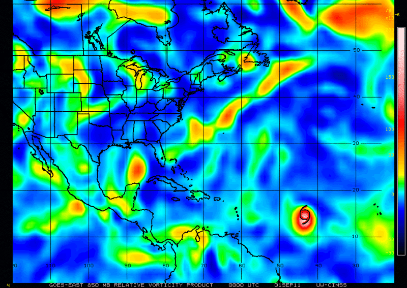
Location: Edinburg/McAllen Tx

#278 Postby Rgv20 » Wed Aug 31, 2011 7:38 pm

0z 850mb Vorticity certainly looking good this evening.

Image
0 likes   
The following post is NOT an official forecast and should not be used as such. It is just the opinion of the poster and may or may not be backed by sound meteorological data. It is NOT endorsed by any professional institution including storm2k.org For Official Information please refer to the NHC and NWS products.

BigB0882
S2K Supporter
S2K Supporter
Posts: 2284
Joined: Thu Jul 03, 2003 12:08 am
Location: Baton Rouge, LA
Contact:

#279 Postby BigB0882 » Wed Aug 31, 2011 7:38 pm

This disappeared off the graphic, has it been repositioned?
0 likes   

surfer_dude
Tropical Low
Tropical Low
Posts: 26
Joined: Tue Aug 30, 2011 7:18 pm
Location: San Antonio, TX

Re: ATL: INVEST 93L - Models

#280 Postby surfer_dude » Wed Aug 31, 2011 7:38 pm

WxGuy1 wrote:models have this thing all over. And I am afraid they are under-estimating its intensity. We could easily have a Category 3 on our hands before Sunday. Conditions are great for development and the dry air to the north has lifted out.
[/quote][/quote]

I don't think anyone should prepare for a Cat 3 just yet. As far as intensity goes, we cant be sure what Cat it will be--What is certain is its going to be a very large storm, especially since there's an 80% chance the low over the Bay of Campeche will get pushed into Invest 93l. You are right though, the ingredients are there.
0 likes   


Return to “2011”

Who is online

Users browsing this forum: No registered users and 9 guests