ATL: INVEST 94L - DISCUSSION
Moderator: S2k Moderators
-
JonathanBelles
- Professional-Met

- Posts: 11430
- Age: 35
- Joined: Sat Dec 24, 2005 9:00 pm
- Location: School: Florida State University (Tallahassee, FL) Home: St. Petersburg, Florida
- Contact:
Re: ATL: INVEST 94L - MODELS
If somebody can point out any LLC at 79.6W, please do. I cannot see anything out there.
0 likes
-
SouthFloridawx

- S2K Supporter

- Posts: 8346
- Age: 47
- Joined: Tue Jul 26, 2005 1:16 am
- Location: Sarasota, FL
- Contact:

-
cycloneye

- Admin

- Posts: 149429
- Age: 69
- Joined: Thu Oct 10, 2002 10:54 am
- Location: San Juan, Puerto Rico
Re: ATL: INVEST 94L - DISCUSSION
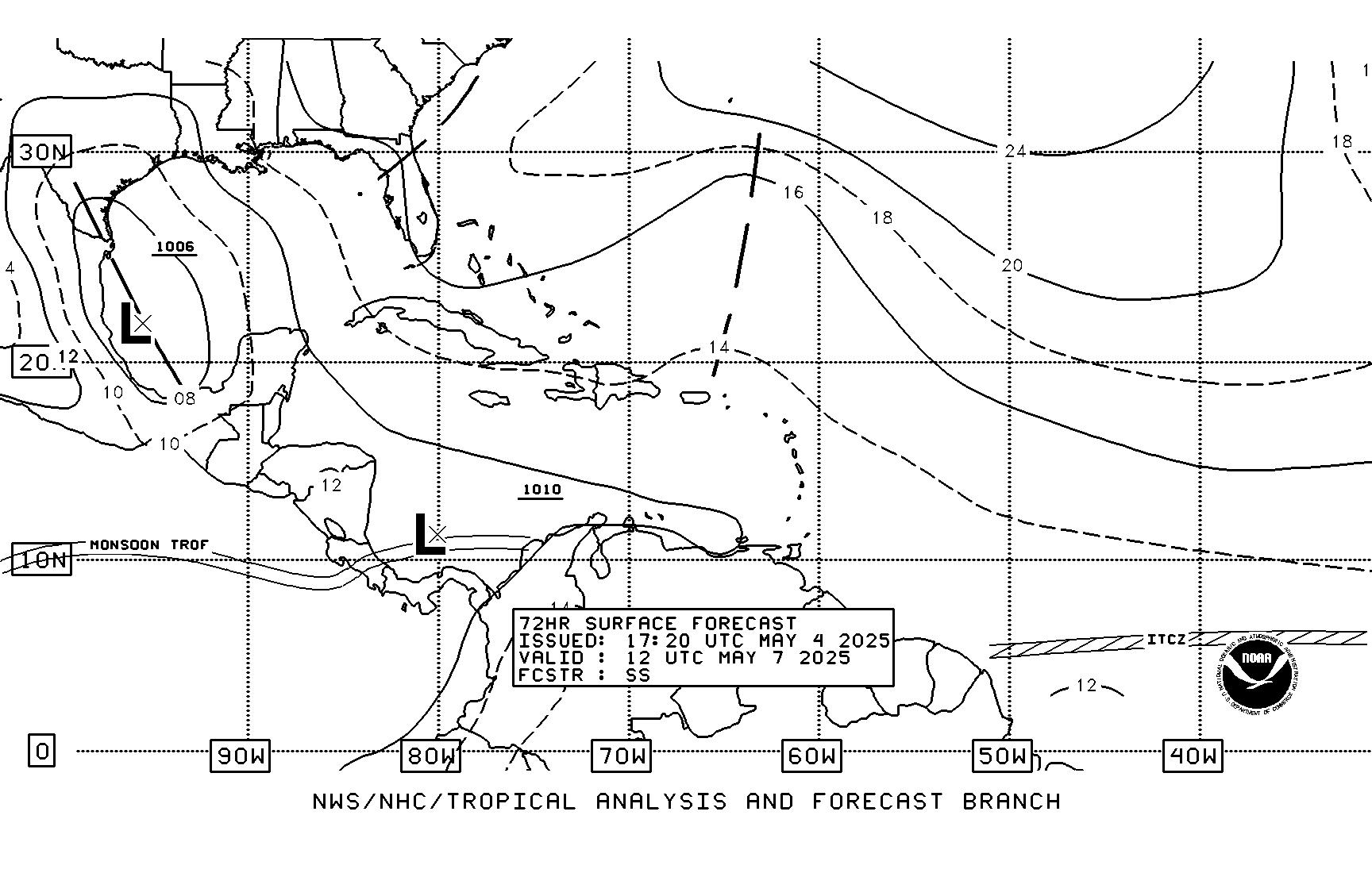
cycloneye wrote:18z Best Track
AL, 94, 2011060518, , BEST, 0, 168N, 796W, 25, 1007, DB
ftp://ftp.tpc.ncep.noaa.gov/atcf/tcweb/ ... 011.invest
We have best track with one position and SSD dvorak T numbers with another. Which is the right one?
SSD Dvorak T Numbers
05/1745 UTC 16.9N 78.8W T1.0/1.0 94L -- Atlantic
http://www.ssd.noaa.gov/PS/TROP/tdpositions.html
0 likes
Visit the Caribbean-Central America Weather Thread where you can find at first post web cams,radars
and observations from Caribbean basin members Click Here
and observations from Caribbean basin members Click Here
-
Weatherfreak000


Re:
psyclone wrote:what happened to the idea floating around yesterday that if this developed it would be shunted off to the north and eventually northeast? that graphic just posted by ivanhater shows very little movement through 72 hours. is the northeast solution unlikely or off the table now?
I wouldn't say its off the table but that solution did require a system developing fairly quickly and tapping into the weakness, models seem quite keen to take it further west then that idea.
0 likes
Personal Forecast Disclaimer:
The posts in this forum are NOT official forecast and should not be used as such. They are just the opinion of the poster and may or may not be backed by sound meteorological data. They are NOT endorsed by any professional institution or storm2k.org. For official information, please refer to the NHC and NWS products
The posts in this forum are NOT official forecast and should not be used as such. They are just the opinion of the poster and may or may not be backed by sound meteorological data. They are NOT endorsed by any professional institution or storm2k.org. For official information, please refer to the NHC and NWS products
-
Ivanhater

- Storm2k Moderator

- Posts: 11221
- Age: 39
- Joined: Fri Jul 01, 2005 8:25 am
- Location: Pensacola
Re: ATL: INVEST 94L - DISCUSSION
Deep convection continues to grow closer to the LLC with the outflow continuing to expand. Helps with the upper high strengthening overhead...
http://www.ssd.noaa.gov/goes/flt/t2/flash-wv.html

http://www.ssd.noaa.gov/goes/flt/t2/flash-wv.html
0 likes
Michael
-
cycloneye
- Admin
- Posts: 149429
- Age: 69
- Joined: Thu Oct 10, 2002 10:54 am
- Location: San Juan, Puerto Rico
Re: ATL: INVEST 94L - DISCUSSION
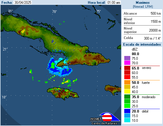
Radar from Cuba shows rotation in the clouds. The radar quality is not so good.
0 likes
Visit the Caribbean-Central America Weather Thread where you can find at first post web cams,radars
and observations from Caribbean basin members Click Here
and observations from Caribbean basin members Click Here
-
Rgv20

- S2K Supporter
- Posts: 2466
- Age: 39
- Joined: Wed Jan 05, 2011 5:42 pm
- Location: Edinburg/McAllen Tx
12z CMC really happy again...
Wednesday morning
Saturday morning
In my opinion is to fast thru the first 72 hours.
Wednesday morning
Saturday morning
In my opinion is to fast thru the first 72 hours.
0 likes
The following post is NOT an official forecast and should not be used as such. It is just the opinion of the poster and may or may not be backed by sound meteorological data. It is NOT endorsed by any professional institution including storm2k.org For Official Information please refer to the NHC and NWS products.
-
SouthFloridawx
- S2K Supporter
- Posts: 8346
- Age: 47
- Joined: Tue Jul 26, 2005 1:16 am
- Location: Sarasota, FL
- Contact:
Re: ATL: INVEST 94L - DISCUSSION
Looking at the Visible floater, it appears that the convection seems to be shifting to the west.
http://www.ssd.noaa.gov/goes/flt/t2/flash-vis.html
http://www.ssd.noaa.gov/goes/flt/t2/flash-vis.html
0 likes
-
jlauderdal
- S2K Supporter
- Posts: 7240
- Joined: Wed May 19, 2004 5:46 am
- Location: NE Fort Lauderdale
- Contact:
Re:
psyclone wrote:what happened to the idea floating around yesterday that if this developed it would be shunted off to the north and eventually northeast? that graphic just posted by ivanhater shows very little movement through 72 hours. is the northeast solution unlikely or off the table now?
this sounds positive
WEATHER CONDITIONS BEYOND WEDNESDAY WILL GREATLY DEPEND ON THE
EVOLUTION AND TRACK OF THE SURFACE LOW CURRENTLY OVER THE WESTERN
CARIBBEAN. MOST MODELS ARE NOW CONVERGING TOWARD A SIMILAR
SOLUTION WITH ECMWF BEING THE MOST PERSISTENT IN BRINGING THIS
SYSTEM SLOWLY NORTH THROUGH EXTREME WESTERN CUBA BY LATE
THURSDAY/EARLY FRIDAY AND INTO THE SOUTHEAST GULF OF MEX BY
SATURDAY. IN DOING SO...ECMWF SIGNIFICANTLY INCREASES THE CHANCES
FOR PRECIP ACROSS SOUTH FLORIDA FRIDAY AND SATURDAY. GFS,
LIKEWISE, INCREASES POPS FOR THIS PERIOD ALTHOUGH DOES NOT SEEM AS
AGGRESSIVE AS THE ECMWF. CURRENT FORECAST CALLS FOR A MODEST
INCREASE IN POPS FOR THIS PERIOD. THIS, HOWEVER, COULD INCREASE
FURTHER IF THE MODELS CONTINUE WITH THIS TREND.
0 likes
-
Rgv20
- S2K Supporter
- Posts: 2466
- Age: 39
- Joined: Wed Jan 05, 2011 5:42 pm
- Location: Edinburg/McAllen Tx
SouthFloridawx wrote:Looking at the Visible floater, it appears that the convection seems to be shifting to the west.
http://www.ssd.noaa.gov/goes/flt/t2/flash-vis.html
Taking that signature comma shape.
0 likes
The following post is NOT an official forecast and should not be used as such. It is just the opinion of the poster and may or may not be backed by sound meteorological data. It is NOT endorsed by any professional institution including storm2k.org For Official Information please refer to the NHC and NWS products.
Good to see the CMC is back on form again developing a top end TS/low end hurricane and makes landfall as a powerful system.
0 likes
Personal Forecast Disclaimer:
The posts in this forum are NOT official forecast and should not be used as such. They are just the opinion of the poster and may or may not be backed by sound meteorological data. They are NOT endorsed by any professional institution or storm2k.org. For official information, please refer to the NHC and NWS products
The posts in this forum are NOT official forecast and should not be used as such. They are just the opinion of the poster and may or may not be backed by sound meteorological data. They are NOT endorsed by any professional institution or storm2k.org. For official information, please refer to the NHC and NWS products
-
Ivanhater
- Storm2k Moderator
- Posts: 11221
- Age: 39
- Joined: Fri Jul 01, 2005 8:25 am
- Location: Pensacola
Re:
KWT wrote:Good to see the CMC is back on form again developing a top end TS/low end hurricane and makes landfall as a powerful system.
Well not so good to see it make landfall at my house
A nice sloppy tropical storm would be welcome here though
0 likes
Michael
-
Rgv20
- S2K Supporter
- Posts: 2466
- Age: 39
- Joined: Wed Jan 05, 2011 5:42 pm
- Location: Edinburg/McAllen Tx
Here is the UKMET.
By Friday morning it has the Low around the Yucatan channel.
0 likes
The following post is NOT an official forecast and should not be used as such. It is just the opinion of the poster and may or may not be backed by sound meteorological data. It is NOT endorsed by any professional institution including storm2k.org For Official Information please refer to the NHC and NWS products.


-
srainhoutx

- S2K Supporter
- Posts: 6919
- Age: 68
- Joined: Sun Jan 14, 2007 11:34 am
- Location: Haywood County, NC
- Contact:
Re: ATL: INVEST 94L - MODELS
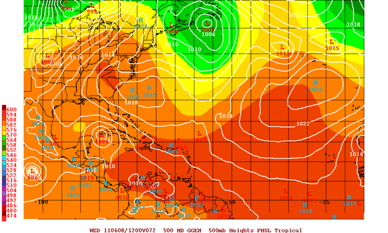
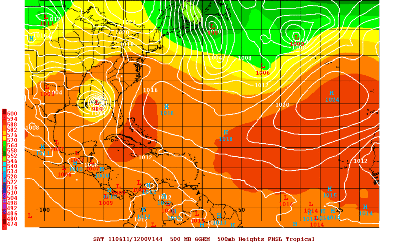
The 12Z HWRF develops 94L quickly and sends it NE. The GFDL develops a TS in the Gulf and turns it W/WNW.
0 likes
Carla/Alicia/Jerry(In The Eye)/Michelle/Charley/Ivan/Dennis/Katrina/Rita/Wilma/Ike/Harvey
Member: National Weather Association
Wx Infinity Forums
http://wxinfinity.com/index.php
Facebook.com/WeatherInfinity
Twitter @WeatherInfinity
Member: National Weather Association
Wx Infinity Forums
http://wxinfinity.com/index.php
Facebook.com/WeatherInfinity
Twitter @WeatherInfinity

-
Rgv20
- S2K Supporter
- Posts: 2466
- Age: 39
- Joined: Wed Jan 05, 2011 5:42 pm
- Location: Edinburg/McAllen Tx
12zGFDL high end tropical storm/category one hurricane in the middle of the Gulf. http://moe.met.fsu.edu/cgi-bin/gfdltc2.cgi?time=2011060512-invest94l&field=Sea+Level+Pressure&hour=Animation
Keep in mind that the HWRF and GFDL are not the best models to follow and a developing tropical cyclone. On the other hand when its already develop they are on the top of the class.
Keep in mind that the HWRF and GFDL are not the best models to follow and a developing tropical cyclone. On the other hand when its already develop they are on the top of the class.
0 likes
The following post is NOT an official forecast and should not be used as such. It is just the opinion of the poster and may or may not be backed by sound meteorological data. It is NOT endorsed by any professional institution including storm2k.org For Official Information please refer to the NHC and NWS products.
Who is online
Users browsing this forum: No registered users and 7 guests