ATL : HARVEY - Tropical Depression - Discussion
Moderator: S2k Moderators

Re: ATL: INVEST 93L - Models
Nice 06Z GFS run in that it shows rain...I can handle a little wind.. 
0 likes
-
Blown Away

- S2K Supporter

- Posts: 10253
- Joined: Wed May 26, 2004 6:17 am
Re: ATL: INVEST 93L - Models

12z TVCN suggests a WNW track towards the NE Caribbean. Those are scary tracks for the EC CONUS when the models move WNW and go just N of the NE Caribbean then bend back towards the W.
0 likes
Hurricane Eye Experience: David 79, Irene 99, Frances 04, Jeanne 04, Wilma 05… Hurricane Brush Experience: Andrew 92, Erin 95, Floyd 99, Matthew 16, Irma 17, Ian 22, Nicole 22…
Re: ATL : INVEST 93L - Discussion
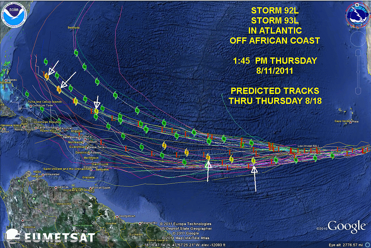
http://www.beaumontweather.com/92L-93L-1345-081111.gif
This is a little old.....Golden Triangle Weather.....they have a little bit of everything on this site.
This is a little old.....Golden Triangle Weather.....they have a little bit of everything on this site.
0 likes
-
cycloneye

- Admin

- Posts: 149368
- Age: 69
- Joined: Thu Oct 10, 2002 10:54 am
- Location: San Juan, Puerto Rico
Re: ATL : INVEST 93L - Discussion
93L may get more favorable conditions down the road as the wet MJO is still forecast to enter the basin after the 15th.

Uploaded by imageshack.us
Uploaded by imageshack.us
0 likes
Visit the Caribbean-Central America Weather Thread where you can find at first post web cams,radars
and observations from Caribbean basin members Click Here
and observations from Caribbean basin members Click Here
-
TreasureIslandFLGal

- S2K Supporter
- Posts: 1584
- Age: 58
- Joined: Sun Aug 15, 2004 6:16 pm
- Location: Cancun, Mexico (northeast Yucatan coast)
Re:
ConvergenceZone wrote:I'm a bit confused about this and if I'm wrong, please let me know. With the Death Ridge that WXMAN and other say will still be in place for quite awhile, how can the models be showing this storm in the gulf anywhere east of the texas Mexican border? Perhaps WXMAN can shine some light on this as well.
Thanks in advance!
I think there is confusion over the term "death ridge". There are actually 2 ridges in play that we have been calling a "death ridge". When the Atlantic/Bermuda high gets really strong and extends westward towards conus, we have been calling that a death ridge.
The folks in Texas and across the southeast have been experiencing their own conus "death ridge" too that has been in place, especially over texas, much of the summer and spring.
The ridge in Texas we would expect to shelter the state and northern gulf from an incoming storm approaching from the gulf, and anything approaching would seemingly follow the southern periphery into Mexico or southern texas.
The space between the atlantic ridge and the conus ridge could supply a pathway for storms to travel between if the weakness between them is big enough.
0 likes
Chrissy & Ligeia

Re: ATL : INVEST 93L - Discussion
The middle Atlantic is still cool and showing early season influences. The question is if it makes it across and re-convects.
0 likes
-
Jevo

- S2K Supporter
- Posts: 1729
- Age: 47
- Joined: Tue Aug 03, 2004 8:45 pm
- Location: The Flemish Cap
- Contact:
Re: ATL : INVEST 93L - Discussion
GAH.. 93L is just looking all sorts of Ugly today..
It coulda been a Contenda!! Not for a little while now..

It coulda been a Contenda!! Not for a little while now..
0 likes
Disclaimer: 50% of the time I have no clue of what I am talking about. Chances are I am taking a less than educated guess that sounds good because 10 years ago I stole Mike Watkins book 'The Hurricane and its Impact'. For official information please direct yourself to the NHC and their cadre of weather geniuses.
-
SkeetoBite

- S2K Supporter
- Posts: 515
- Age: 60
- Joined: Fri Sep 03, 2004 8:25 am
- Contact:
Re: ATL: INVEST 93L - Models
wxman57 wrote:My prediction is it will eventually make landfall somewhere between Mexico and Bermuda.
Well,that's enough for me. Off to the store for fresh batteries...
0 likes

-
Tireman4

- S2K Supporter
- Posts: 5903
- Age: 60
- Joined: Fri Jun 30, 2006 1:08 pm
- Location: Humble, Texas
- Contact:
Re: ATL: INVEST 93L - Models
wxman57 wrote:My prediction is it will eventually make landfall somewhere between Mexico and Bermuda.
And that folks is why he gets paid the big bucks. Woo Hoo. Next storm please...
0 likes
-
ConvergenceZone
.gif)
- Category 5

- Posts: 5241
- Joined: Fri Jul 29, 2005 1:40 am
- Location: Northern California
Re: ATL : INVEST 93L - Discussion
Jevo wrote:GAH.. 93L is just looking all sorts of Ugly today..
It coulda been a Contenda!! Not for a little while now..
I ageee. Also the NHC percentage chance of development will probably be coming down today. I don't see any reason at all for it to remain at 40%.... 10 to 20 is much more likely.
0 likes

Re: ATL : INVEST 93L - Discussion
Ivanhater wrote:All that probably means is development further west which puts the U.S coast at a greater risk. Remember 2005, most waves developed west of 55 degrees.
That's true, but in 2005 did we have this type of persistent death ridge over the south central U.S.?
0 likes
Re: ATL : INVEST 93L - Discussion
cycloneye wrote:93L may get more favorable conditions down the road as the wet MJO is still forecast to enter the basin after the 15th.
I've asked this question previously with no one answering, but how accurate have the historical MJO forecasts been?
0 likes
Re: ATL: INVEST 93L - Models
wxman57 wrote:My prediction is it will eventually make landfall somewhere between Mexico and Bermuda.
You didn't put the disclaimer. I'm reporting this post.
0 likes
-
Portastorm

- Storm2k Moderator

- Posts: 9955
- Age: 63
- Joined: Fri Jul 11, 2003 9:16 am
- Location: Round Rock, TX
- Contact:
Re: ATL : INVEST 93L - Discussion
SoupBone wrote:cycloneye wrote:93L may get more favorable conditions down the road as the wet MJO is still forecast to enter the basin after the 15th.
I've asked this question previously with no one answering, but how accurate have the historical MJO forecasts been?
I have no clue but to provide you with at least *some* answer ... here is a link to a scholarly article which examines MJO forecasts:
http://cawcr.gov.au/bmrc/clfor/cfstaff/matw/abstracts/Gottschalck-Text.pdf
0 likes
Any forecasts under my name are to be taken with a grain of salt. Get your best forecasts from the National Weather Service and National Hurricane Center.
Re: ATL : INVEST 93L - Discussion
Portastorm wrote:SoupBone wrote:cycloneye wrote:93L may get more favorable conditions down the road as the wet MJO is still forecast to enter the basin after the 15th.
I've asked this question previously with no one answering, but how accurate have the historical MJO forecasts been?
I have no clue but to provide you with at least *some* answer ... here is a link to a scholarly article which examines MJO forecasts:
http://cawcr.gov.au/bmrc/clfor/cfstaff/matw/abstracts/Gottschalck-Text.pdf
I'll take a look at that. Thanks!
I always see references to the MJO forecasts, but I could never find anything that show how accurate or inaccurate they are.
0 likes
-
Kory
- Tropical Storm

- Posts: 200
- Age: 30
- Joined: Tue Aug 02, 2011 11:32 am
- Location: New Orleans, Louisiana
It also shows the death ridge reestablishing itself across the south central United States...guess there is just no relief for those in Texas. Now if it were to become a stronger storm, we'd have to see if it could erode the ridge. Too early to tell...
The posts in this forum are NOT official forecast and should not be used as such. They are just the opinion of the poster and may or may not be backed by sound meteorological data. They are NOT endorsed by any professional institution or storm2k.org. For official information, please refer to the NHC and NWS products.
The posts in this forum are NOT official forecast and should not be used as such. They are just the opinion of the poster and may or may not be backed by sound meteorological data. They are NOT endorsed by any professional institution or storm2k.org. For official information, please refer to the NHC and NWS products.
0 likes
-
wxman57

- Moderator-Pro Met

- Posts: 23172
- Age: 68
- Joined: Sat Jun 21, 2003 8:06 pm
- Location: Houston, TX (southwest)
Re: ATL : INVEST 93L - Discussion
SoupBone wrote:
I always see references to the MJO forecasts, but I could never find anything that show how accurate or inaccurate they are.
Note that there is NO MJO forecast to reach the East Pacific over the coming weeks. If you check the weekly MJO site, they discuss that prediction of some increased convection over the East Pac and Gulf/Caribbean being related to other things, not the MJO.
http://www.cpc.ncep.noaa.gov/products/p ... update.pdf
http://www.cpc.ncep.noaa.gov/products/p ... update.ppt
0 likes
Who is online
Users browsing this forum: No registered users and 13 guests