000
URNT15 KNHC 232114
AF306 01KKA INVEST HDOB 34 20111023
210430 1439N 08201W 9879 00186 0092 +235 +221 279031 032 031 000 03
210500 1439N 08158W 9883 00184 0093 +235 +224 278029 030 030 000 00
210530 1438N 08156W 9884 00182 0093 +236 +221 282028 029 029 001 03
210600 1438N 08154W 9881 00184 0092 +235 +224 281026 027 025 000 03
210630 1439N 08152W 9883 00181 0090 +233 +219 278030 031 029 000 03
210700 1440N 08150W 9882 00182 0090 +234 +214 274029 030 029 001 00
210730 1441N 08148W 9878 00187 0090 +239 +223 264027 027 029 000 00
210800 1441N 08146W 9885 00178 0089 +240 +222 262025 026 024 000 03
210830 1443N 08144W 9891 00161 0083 +239 +222 259024 025 /// /// 03
210900 1445N 08143W 9866 00197 0093 +239 +218 253025 025 026 000 03
210930 1446N 08141W 9849 00214 0092 +240 +219 251022 024 023 000 00
211000 1448N 08140W 9799 00255 0092 +237 +219 252023 023 022 000 03
211030 1449N 08138W 9863 00203 0093 +240 +222 249022 022 020 000 00
211100 1449N 08136W 9866 00201 0093 +240 +221 243023 024 022 000 03
211130 1449N 08134W 9886 00182 0093 +240 +227 235022 023 022 000 00
211200 1450N 08131W 9883 00184 0093 +243 +226 236021 022 022 000 00
211230 1450N 08129W 9885 00181 0092 +245 +223 240021 022 021 000 00
211300 1451N 08127W 9885 00183 0092 +245 +222 240021 022 021 001 00
211330 1451N 08125W 9881 00186 0092 +245 +221 239020 020 020 000 00
211400 1451N 08123W 9890 00178 0091 +247 +220 238021 022 021 000 00
$$
;
ATL: RINA - Post-Tropical - Discussion
Moderator: S2k Moderators
-
Evil Jeremy

- S2K Supporter

- Posts: 5463
- Age: 32
- Joined: Mon Apr 10, 2006 2:10 pm
- Location: Los Angeles, CA

-
wxman57

- Moderator-Pro Met

- Posts: 23099
- Age: 68
- Joined: Sat Jun 21, 2003 8:06 pm
- Location: Houston, TX (southwest)
Re: ATL: EIGHTEEN - Tropical Depression - Discussion
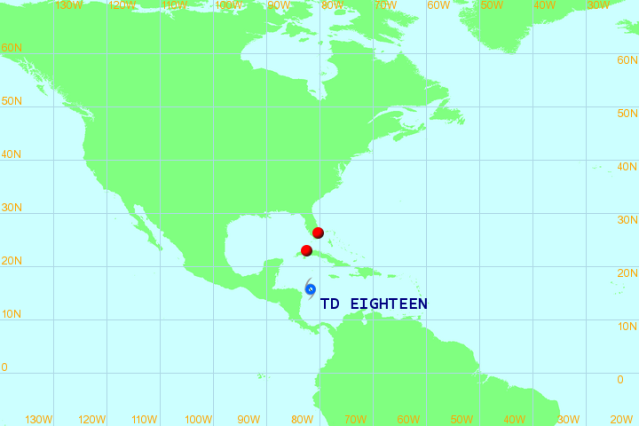
I suspect it will move faster than the NHC is forecasting on Thu/Fri and be located between western Cuba and the NE Yucatan on Friday afternoon. Movement by then would be to the NE as the front approaches. I'm not sure if the circulation will remain intact as it passes through the FL Straits next Saturday, as it'll probably be merging with the cold front.
0 likes
-
AdamFirst

- S2K Supporter
- Posts: 2490
- Age: 36
- Joined: Thu Aug 14, 2008 10:54 am
- Location: Port Saint Lucie, FL
Re: ATL: EIGHTEEN - Tropical Depression - Discussion
wxman57 wrote:I suspect it will move faster than the NHC is forecasting on Thu/Fri and be located between western Cuba and the NE Yucatan on Friday afternoon. Movement by then would be to the NE as the front approaches. I'm not sure if the circulation will remain intact as it passes through the FL Straits next Saturday, as it'll probably be merging with the cold front.
Similar to last week's rain event that brought severe weather with isolated tornadoes?
0 likes
Dolphins Marlins Canes Golden Panthers HEAT
Andrew 1992 - Irene 1999 - Frances 2004 - Jeanne 2004 - Wilma 2005 - Fay 2008 - Isaac 2012 - Matthew 2016 - Irma 2017 - Dorian 2019 - Ian 2022 - Nicole 2022 - Milton 2024
Andrew 1992 - Irene 1999 - Frances 2004 - Jeanne 2004 - Wilma 2005 - Fay 2008 - Isaac 2012 - Matthew 2016 - Irma 2017 - Dorian 2019 - Ian 2022 - Nicole 2022 - Milton 2024

Unflagged TS force winds found should be Rina soon.
205630 1453N 08230W 9877 00177 0080 +237 +221 296032 033 035 002 00
205700 1452N 08228W 9883 00173 0079 +240 +219 298030 031 034 002 00
205630 1453N 08230W 9877 00177 0080 +237 +221 296032 033 035 002 00
205700 1452N 08228W 9883 00173 0079 +240 +219 298030 031 034 002 00
0 likes
The following post is NOT an official forecast and should not be used as such. It is just the opinion of the poster and may or may not be backed by sound meteorological data. It is NOT endorsed by any professional institution including storm2k.org For Official Information please refer to the NHC and NWS products.
000
URNT15 KNHC 232124
AF306 01KKA INVEST HDOB 35 20111023
211430 1452N 08121W 9891 00173 0087 +249 +221 235021 021 021 000 00
211500 1452N 08119W 9880 00177 0082 +246 +224 232020 021 020 000 00
211530 1453N 08117W 9879 00181 0083 +247 +224 230020 020 020 000 00
211600 1453N 08116W 9877 00182 0084 +248 +224 230020 020 020 000 00
211630 1453N 08114W 9879 00180 0083 +249 +223 229020 020 021 000 00
211700 1454N 08112W 9877 00180 0083 +248 +223 227020 020 019 000 03
211730 1455N 08111W 9864 00192 0083 +247 +227 223017 019 /// /// 03
211800 1456N 08112W 9881 00182 0088 +247 +224 215015 015 017 000 03
211830 1457N 08114W 9877 00186 0089 +246 +224 210015 015 016 000 00
211900 1459N 08115W 9884 00182 0090 +249 +221 209014 015 018 000 00
211930 1500N 08117W 9881 00182 0089 +248 +222 203014 014 017 000 03
212000 1502N 08118W 9885 00178 0089 +246 +222 208012 012 017 000 00
212030 1503N 08120W 9882 00180 0087 +245 +219 207011 012 015 000 03
212100 1505N 08121W 9882 00177 0085 +241 +226 220011 012 017 000 00
212130 1506N 08123W 9883 00177 0085 +245 +220 207011 012 017 000 00
212200 1508N 08124W 9884 00176 0085 +249 +210 187012 012 016 000 00
212230 1509N 08126W 9884 00177 0086 +246 +215 187011 011 015 000 00
212300 1511N 08127W 9893 00169 0087 +245 +221 184010 011 013 000 00
212330 1512N 08129W 9879 00183 0088 +245 +222 183010 011 011 000 00
212400 1514N 08130W 9882 00181 0088 +245 +219 186010 011 011 000 00
$$
;
000
URNT15 KNHC 232134
AF306 01KKA INVEST HDOB 36 20111023
212430 1515N 08132W 9882 00181 0088 +245 +218 190011 011 010 000 00
212500 1516N 08133W 9883 00181 0088 +245 +218 189010 011 008 000 03
212530 1518N 08135W 9881 00182 0088 +245 +216 192010 010 009 000 03
212600 1519N 08136W 9879 00182 0087 +245 +219 192009 010 007 000 03
212630 1519N 08138W 9890 00170 0085 +245 +221 199008 009 009 000 03
212700 1520N 08140W 9876 00180 0081 +245 +222 206008 009 009 000 00
212730 1520N 08142W 9880 00177 0081 +245 +224 224006 007 009 000 00
212800 1521N 08144W 9879 00178 0081 +245 +227 226005 005 004 001 00
212830 1521N 08145W 9880 00177 0082 +244 +227 236006 007 007 000 03
212900 1522N 08147W 9888 00172 0082 +244 +229 259006 007 015 000 03
212930 1523N 08148W 9875 00182 0082 +237 +228 271008 008 010 000 00
213000 1524N 08150W 9879 00177 0081 +239 +225 283007 008 008 000 03
213030 1525N 08151W 9874 00181 0082 +240 +229 303007 008 012 000 03
213100 1527N 08152W 9876 00181 0082 +240 +229 298009 010 014 000 03
213130 1528N 08152W 9888 00167 0081 +241 +227 291009 010 014 000 03
213200 1530N 08152W 9878 00176 0079 +240 +229 293011 011 014 000 00
213230 1532N 08151W 9883 00170 0077 +240 +228 289011 012 013 000 03
213300 1533N 08151W 9878 00177 0079 +240 +230 282011 012 013 000 00
213330 1535N 08150W 9879 00175 0078 +242 +231 275010 010 012 000 03
213400 1536N 08150W 9879 00173 0076 +245 +232 267008 009 009 000 00
$$
;
000
URNT15 KNHC 232144
AF306 01KKA INVEST HDOB 37 20111023
213430 1538N 08149W 9882 00170 0075 +246 +230 222008 011 014 000 00
213500 1540N 08149W 9879 00176 0078 +247 +230 184011 012 009 000 00
213530 1542N 08148W 9879 00177 0079 +249 +225 168013 013 009 000 03
213600 1543N 08148W 9878 00177 0080 +247 +230 166013 013 010 000 00
213630 1545N 08147W 9879 00176 0079 +245 +231 159014 014 011 000 00
213700 1547N 08147W 9880 00175 0079 +245 +229 159013 014 009 000 03
213730 1549N 08146W 9881 00172 0077 +246 +229 159012 013 /// /// 03
213800 1550N 08148W 9877 00177 0078 +245 +229 149012 012 /// /// 03
213830 1549N 08149W 9878 00178 0080 +247 +231 144010 010 007 001 03
213900 1549N 08151W 9891 00164 0078 +250 +231 143009 009 009 000 03
213930 1548N 08152W 9886 00170 0077 +250 +230 141009 010 010 000 00
214000 1547N 08154W 9875 00176 0076 +250 +231 123005 008 011 000 00
214030 1546N 08155W 9874 00178 0076 +245 +236 001008 013 011 000 03
214100 1545N 08156W 9877 00173 0075 +243 +233 355013 015 /// /// 03
214130 1546N 08158W 9875 00180 0078 +240 +232 353015 015 016 000 03
214200 1547N 08159W 9880 00175 0078 +240 +232 351015 016 022 000 00
214230 1548N 08200W 9878 00180 0080 +240 +231 350017 018 023 000 03
214300 1549N 08201W 9880 00176 0080 +236 +232 352020 020 024 000 00
214330 1550N 08202W 9880 00176 0082 +235 +230 350021 022 025 000 03
214400 1551N 08203W 9880 00176 0080 +235 +228 352021 022 026 000 00
$$
;
000
URNT15 KNHC 232154
AF306 01KKA INVEST HDOB 38 20111023
214430 1553N 08204W 9873 00186 0084 +235 +226 354021 021 026 000 03
214500 1554N 08205W 9880 00178 0085 +235 +226 349021 022 027 000 03
214530 1555N 08206W 9883 00176 0085 +235 +226 346021 022 027 000 00
214600 1556N 08207W 9875 00183 0086 +233 +224 343021 021 027 000 03
214630 1557N 08209W 9880 00180 0086 +232 +222 340020 021 026 000 00
214700 1558N 08210W 9882 00180 0087 +231 +220 339020 020 027 000 03
214730 1600N 08211W 9878 00184 0087 +231 +218 337020 021 026 000 00
214800 1601N 08212W 9880 00182 0088 +231 +224 331019 020 027 000 03
214830 1602N 08213W 9882 00182 0089 +230 +223 324019 020 027 001 03
214900 1603N 08214W 9875 00187 0088 +230 +223 321019 019 028 000 03
214930 1604N 08216W 9872 00191 0090 +228 +221 321018 018 026 000 00
215000 1606N 08217W 9882 00183 0092 +230 +216 318016 017 024 000 00
215030 1607N 08218W 9894 00171 0091 +230 +224 320014 015 021 000 00
215100 1608N 08219W 9885 00177 0087 +230 +222 321013 013 018 000 00
215130 1609N 08220W 9875 00186 0087 +232 +215 325010 012 015 000 00
215200 1610N 08221W 9878 00183 0088 +233 +213 331009 010 010 000 03
215230 1611N 08223W 9879 00183 0089 +233 +213 350011 012 015 001 03
215300 1612N 08224W 9880 00181 0087 +231 +214 357010 011 021 001 03
215330 1612N 08225W 9878 00182 0089 +229 +222 356012 013 016 001 03
215400 1611N 08227W 9882 00180 0089 +226 +222 344014 015 015 000 03
$$
;
0 likes
000
URNT15 KNHC 232204
AF306 01KKA INVEST HDOB 39 20111023
215430 1610N 08228W 9879 00182 0089 +228 +223 334020 022 023 000 00
215500 1608N 08229W 9877 00186 0089 +226 +218 332024 024 024 001 00
215530 1607N 08230W 9880 00182 0089 +226 +216 332025 026 026 001 03
215600 1605N 08231W 9883 00180 0089 +224 +222 333027 027 027 001 03
215630 1604N 08231W 9880 00182 0088 +225 //// 336026 027 026 000 01
215700 1602N 08232W 9860 00199 0088 +226 +224 336029 031 027 000 03
215730 1601N 08233W 9883 00181 0091 +230 +217 335028 029 028 000 03
215800 1559N 08233W 9880 00182 0090 +232 +209 331027 027 026 000 03
215830 1557N 08233W 9876 00191 0092 +232 +217 332028 028 030 000 00
215900 1555N 08233W 9880 00187 0093 +235 +223 336027 027 027 001 03
215930 1553N 08233W 9878 00187 0091 +236 +218 332027 027 026 000 00
220000 1551N 08232W 9883 00182 0091 +236 +218 332028 028 027 000 00
220030 1549N 08232W 9882 00184 0092 +235 +224 334028 028 028 000 03
220100 1547N 08231W 9881 00183 0091 +235 +227 337028 028 028 000 00
220130 1545N 08231W 9880 00183 0090 +238 +221 339026 027 027 001 03
220200 1543N 08230W 9876 00188 0091 +240 +218 337024 025 024 000 03
220230 1541N 08230W 9878 00184 0090 +240 +223 333023 024 025 000 03
220300 1539N 08229W 9884 00181 0091 +240 +219 331019 021 018 000 03
220330 1538N 08228W 9888 00178 0091 +235 +225 314018 020 020 000 03
220400 1536N 08228W 9875 00184 0087 +230 +225 313020 021 021 001 03
$$
;
0 likes
-
ozonepete
- Professional-Met

- Posts: 4743
- Joined: Mon Sep 07, 2009 3:23 pm
- Location: From Ozone Park, NYC / Now in Brooklyn, NY
Re: ATL: EIGHTEEN - Tropical Depression - Discussion
Interesting - the WMO has a different track. I just happened to stumble across this while I was looking at the Allmetsat site. I check them once in a while because they have really cool satellite images. I just noticed they have a tropical info tab and I followed it until I got this. The WMO says they get it from RSMC (Regional Specialized Meteorological Centre) which in turn says the RSMC for the Atlantic info is the NHC out of Miami. But this track sure isn't what the NHC has. Anyway, just thought it was interesting.
0 likes
If anyone could take over HDOBs it would be much appreciated 
000
URNT15 KNHC 232214
AF306 01KKA INVEST HDOB 40 20111023
220430 1534N 08227W 9882 00182 0089 +230 +224 304021 022 022 000 00
220500 1532N 08227W 9875 00167 0066 +235 +224 307022 023 023 001 00
220530 1531N 08226W 9875 00168 0066 +235 +222 311024 024 023 002 00
220600 1529N 08226W 9876 00166 0066 +235 +222 308024 024 025 000 03
220630 1527N 08226W 9877 00167 0067 +235 +220 306023 024 025 001 00
220700 1526N 08225W 9875 00168 0067 +236 +217 308023 024 027 000 00
220730 1524N 08225W 9840 00200 0067 +233 +218 310023 024 027 002 00
220800 1522N 08224W 9845 00196 0068 +221 //// 314024 025 030 002 01
220830 1521N 08224W 9840 00199 0067 +224 +224 319027 027 030 001 00
220900 1519N 08224W 9843 00197 0068 +221 //// 317026 027 033 001 01
220930 1517N 08224W 9838 00202 0068 +230 +230 302027 029 027 002 03
221000 1516N 08223W 9844 00196 0067 +229 //// 295028 029 027 000 05
221030 1514N 08222W 9841 00198 0067 +231 +230 293029 030 031 000 03
221100 1514N 08220W 9841 00199 0067 +233 +228 295026 026 025 001 03
221130 1514N 08219W 9839 00200 0066 +236 +228 295025 026 027 000 03
221200 1514N 08217W 9844 00194 0067 +233 +223 311020 021 024 001 03
221230 1514N 08215W 9842 00197 0066 +230 +222 314021 022 026 002 00
221300 1515N 08214W 9840 00199 0066 +230 +224 313020 021 027 002 00
221330 1515N 08212W 9845 00193 0065 +230 +223 316021 021 025 000 03
221400 1516N 08210W 9842 00196 0065 +227 +224 310021 021 028 001 00
$$
;
0 likes
000
URNT15 KNHC 232224
AF306 01KKA INVEST HDOB 41 20111023
221430 1517N 08209W 9775 00254 0066 +212 //// 301021 022 032 004 01
221500 1517N 08207W 9748 00281 0066 +227 //// 305017 018 028 003 05
221530 1518N 08206W 9752 00276 0065 +230 +227 310017 018 018 000 03
221600 1517N 08204W 9749 00278 0065 +227 +226 307017 018 025 002 00
221630 1516N 08202W 9777 00253 0064 +227 +224 312017 017 014 002 00
221700 1516N 08201W 9767 00261 0063 +235 +211 300017 017 012 000 03
221730 1516N 08159W 9774 00254 0062 +236 +214 289015 016 015 000 00
221800 1516N 08157W 9769 00260 0062 +234 +217 287015 016 015 000 00
221830 1516N 08156W 9774 00256 0063 +235 +221 280013 014 010 000 03
221900 1517N 08155W 9771 00258 0063 +230 +225 283014 015 010 000 03
221930 1519N 08154W 9819 00214 0062 +236 +226 279013 013 013 001 00
222000 1520N 08154W 9848 00188 0061 +233 +229 275016 018 018 001 03
222030 1522N 08154W 9832 00201 0060 +234 +228 272015 017 016 000 00
222100 1523N 08154W 9837 00198 0061 +240 +226 286009 011 006 001 03
222130 1525N 08154W 9849 00187 0061 +240 +229 306014 015 018 000 03
222200 1527N 08154W 9840 00194 0061 +238 +229 296014 014 014 000 03
222230 1529N 08155W 9843 00191 0060 +238 +228 290014 014 014 000 00
222300 1530N 08155W 9841 00193 0060 +240 +224 288014 014 012 000 03
222330 1532N 08155W 9844 00189 0059 +240 +227 285014 015 013 000 03
222400 1534N 08154W 9841 00192 0059 +239 +229 277015 015 015 000 03
$$
;
0 likes
-
cycloneye

- Admin

- Posts: 148583
- Age: 69
- Joined: Thu Oct 10, 2002 10:54 am
- Location: San Juan, Puerto Rico
Re: ATL: EIGHTEEN - Recon Discussion
I will continue.
0 likes
Visit the Caribbean-Central America Weather Thread where you can find at first post web cams,radars
and observations from Caribbean basin members Click Here
and observations from Caribbean basin members Click Here
-
cycloneye
- Admin
- Posts: 148583
- Age: 69
- Joined: Thu Oct 10, 2002 10:54 am
- Location: San Juan, Puerto Rico
Re: ATL: EIGHTEEN - Recon
Decoded vortex message.
Product: Air Force Vortex Message (URNT12 KNHC)
Transmitted: 23rd day of the month at 22:03Z
Aircraft: Air Force Aircraft (Last 3 digits of the tail number are 306)
Mission Purpose: Investigate tenth suspect area (flight in the North Atlantic basin)
Mission Number: 1
Observation Number: 17
A. Time of Center Fix: 23rd day of the month at 21:40:10Z
B. Center Fix Coordinates: 15°47'N 81°54'W (15.7833N 81.9W) (View map)
B. Center Fix Location: 246 miles (396 km) to the S (188°) from George Town, Cayman Islands (GBR).
C. Minimum Height at Standard Level: Not Available
D. Estimated (by SFMR or visually) Maximum Surface Wind: 19kts (~ 21.9mph)
E. Location of the Estimated Maximum Surface Wind: 65 nautical miles (75 statute miles) to the SE (143°) of center fix
F. Maximum Flight Level Wind Inbound: From 226° at 20kts (From the SW at ~ 23.0mph)
G. Location of Maximum Flight Level Wind Inbound: 66 nautical miles (76 statute miles) to the SE (142°) of center fix
H. Minimum Sea Level Pressure: 1008mb (29.77 inHg) - Extrapolated
I. Maximum Flight Level Temp & Pressure Altitude Outside Eye: 23°C (73°F) at a pressure alt. of 212m (696ft)
J. Maximum Flight Level Temp & Pressure Altitude Inside Eye: 25°C (77°F) at a pressure alt. of 214m (702ft)
K. Dewpoint Temp (collected at same location as temp inside eye): 23°C (73°F)
K. Sea Surface Temp (collected at same location as temp inside eye): Not Available
L. Eye Character: Not Available
M. Eye Shape: Not Available
O. Navigation Fix Accuracy: 0.02 nautical miles
O. Meteorological Accuracy: 8 nautical miles
Remarks Section:
Maximum Flight Level Wind: 36kts (~ 41.4mph) in the southwest quadrant at 20:55:30Z
Maximum Flight Level Wind Outbound: 27kts (~ 31.1mph) in the northwest quadrant at 21:56:50Z
Sea Level Pressure Extrapolation From: Below 1,500 feet
Maximum Flight Level Temp: 25°C (77°F) which was observed 47 nautical miles (54 statute miles) to the SE (143°) from the flight level center
0 likes
Visit the Caribbean-Central America Weather Thread where you can find at first post web cams,radars
and observations from Caribbean basin members Click Here
and observations from Caribbean basin members Click Here
-
cycloneye
- Admin
- Posts: 148583
- Age: 69
- Joined: Thu Oct 10, 2002 10:54 am
- Location: San Juan, Puerto Rico
Re: ATL: EIGHTEEN - Recon
Another pass thru center.
URNT15 KNHC 232234
AF306 01KKA INVEST HDOB 42 20111023
222430 1536N 08154W 9840 00193 0059 +240 +229 272015 015 012 000 03
222500 1537N 08153W 9857 00177 0058 +244 +226 268014 015 011 000 00
222530 1539N 08153W 9844 00186 0055 +246 +225 258017 018 018 000 00
222600 1541N 08153W 9852 00176 0053 +248 +231 246010 016 013 000 03
222630 1542N 08153W 9843 00184 0051 +248 +230 161000 003 002 000 03
222700 1544N 08153W 9829 00199 0053 +243 +228 132003 005 003 000 03
222730 1546N 08153W 9835 00194 0055 +245 +226 134007 009 005 000 03
222800 1548N 08153W 9841 00191 0057 +247 +229 129011 012 005 000 03
222830 1548N 08153W 9841 00191 0058 +248 +227 127011 011 005 001 03
222900 1552N 08153W 9842 00192 0059 +249 +225 130008 009 006 001 03
222930 1554N 08153W 9841 00193 0059 +247 +230 142007 007 007 000 03
223000 1556N 08153W 9841 00193 0060 +245 +230 157005 007 010 000 00
223030 1558N 08153W 9854 00183 0061 +240 +230 006009 013 017 001 03
223100 1559N 08153W 9850 00181 0057 +240 +228 358010 012 018 000 03
223130 1601N 08153W 9842 00189 0056 +241 +229 356007 010 015 000 00
223200 1602N 08153W 9842 00189 0057 +239 +228 334007 010 016 000 03
223230 1604N 08153W 9849 00183 0056 +242 +227 343003 006 017 000 00
223300 1605N 08153W 9844 00187 0056 +241 +225 321006 008 018 000 00
223330 1607N 08152W 9840 00191 0057 +243 +225 332005 006 016 001 03
223400 1608N 08152W 9837 00193 0057 +240 +226 313003 004 014 001 00
$$
0 likes
Visit the Caribbean-Central America Weather Thread where you can find at first post web cams,radars
and observations from Caribbean basin members Click Here
and observations from Caribbean basin members Click Here
-
cycloneye
- Admin
- Posts: 148583
- Age: 69
- Joined: Thu Oct 10, 2002 10:54 am
- Location: San Juan, Puerto Rico
Re: ATL: EIGHTEEN - Tropical Depression - Discussion
Plane just made another pass with lowest pressure at 1005.1 mbs.
0 likes
Visit the Caribbean-Central America Weather Thread where you can find at first post web cams,radars
and observations from Caribbean basin members Click Here
and observations from Caribbean basin members Click Here
-
cycloneye
- Admin
- Posts: 148583
- Age: 69
- Joined: Thu Oct 10, 2002 10:54 am
- Location: San Juan, Puerto Rico
Re: ATL: EIGHTEEN - Recon
URNT15 KNHC 232244
AF306 01KKA INVEST HDOB 43 20111023
223430 1610N 08152W 9842 00190 0058 +241 +227 313003 004 016 001 03
223500 1612N 08152W 9832 00199 0058 +242 +227 173001 004 009 000 03
223530 1613N 08151W 9845 00188 0058 +247 +227 153003 005 008 000 00
223600 1615N 08151W 9838 00194 0058 +246 +229 168003 005 008 000 03
223630 1616N 08150W 9840 00194 0059 +247 +231 161007 010 008 000 00
223700 1618N 08150W 9840 00193 0060 +252 +229 145009 012 007 000 03
223730 1620N 08150W 9844 00190 0059 +248 +232 162008 012 /// /// 03
223800 1621N 08149W 9837 00196 0059 +255 +225 160016 016 012 000 00
223830 1622N 08147W 9843 00192 0060 +255 +224 156017 018 014 000 00
223900 1623N 08146W 9842 00193 0060 +254 +227 148017 017 011 000 00
223930 1624N 08144W 9841 00193 0059 +255 +227 149017 018 013 000 00
224000 1625N 08143W 9839 00195 0059 +253 +225 151020 022 004 001 03
224030 1627N 08142W 9843 00192 0060 +252 +231 151018 019 018 000 03
224100 1628N 08141W 9844 00191 0060 +256 +228 141021 022 015 000 00
224130 1630N 08140W 9843 00192 0060 +255 +229 138021 022 015 000 03
224200 1631N 08139W 9842 00194 0061 +256 +225 136022 022 017 000 00
224230 1633N 08139W 9840 00195 0060 +260 +221 134023 024 017 000 03
224300 1635N 08139W 9842 00194 0060 +260 +220 137025 026 019 001 00
224330 1637N 08138W 9842 00192 0059 +260 +227 136025 026 024 000 03
224400 1639N 08138W 9842 00192 0059 +259 +232 137026 026 022 000 00
0 likes
Visit the Caribbean-Central America Weather Thread where you can find at first post web cams,radars
and observations from Caribbean basin members Click Here
and observations from Caribbean basin members Click Here
Re: ATL: EIGHTEEN - Recon Discussion
cycloneye wrote:I will continue.
Thanks!
0 likes
The following post is NOT an official forecast and should not be used as such. It is just the opinion of the poster and may or may not be backed by sound meteorological data. It is NOT endorsed by any professional institution including storm2k.org For Official Information please refer to the NHC and NWS products.
-
cycloneye
- Admin
- Posts: 148583
- Age: 69
- Joined: Thu Oct 10, 2002 10:54 am
- Location: San Juan, Puerto Rico
Re: ATL: EIGHTEEN - Recon
URNT15 KNHC 232254
AF306 01KKA INVEST HDOB 44 20111023
224430 1641N 08138W 9601 00412 0053 +242 +224 131026 027 /// /// 03
224500 1643N 08138W 9232 00752 0058 +218 +192 128028 030 /// /// 03
224530 1645N 08138W 8894 01080 0069 +198 +168 128030 030 019 000 03
224600 1646N 08137W 8539 01443 0077 +178 +148 126029 029 018 001 03
224630 1648N 08136W 8222 01768 0079 +159 +127 128029 030 020 000 00
224700 1650N 08136W 7920 02085 0079 +145 +113 132028 029 019 000 03
224730 1651N 08135W 7660 02364 0063 +137 +107 137028 028 020 000 03
224800 1653N 08134W 7448 02605 0062 +125 +094 141028 029 018 000 00
224830 1654N 08133W 7265 02813 0060 +113 +086 147028 029 010 000 00
224900 1656N 08132W 7090 03017 0061 +103 +076 157030 030 017 000 03
224930 1657N 08130W 6976 03157 0066 +093 +069 163030 030 013 001 03
225000 1659N 08129W 6954 03180 0069 +087 +067 163030 030 015 000 03
225030 1700N 08127W 6974 03156 0066 +090 +065 162030 030 016 000 03
225100 1702N 08126W 6967 03165 0068 +090 +063 161031 031 015 000 00
225130 1704N 08125W 6966 03168 0065 +095 +061 159029 030 017 000 03
225200 1706N 08124W 6967 03167 0072 +091 +057 152029 030 /// /// 03
225230 1708N 08124W 6966 03169 0067 +092 +055 145031 032 013 000 00
225300 1710N 08125W 6966 03168 0072 +089 +056 141029 030 011 000 03
225330 1712N 08126W 6971 03163 0070 +090 +048 138029 029 010 000 00
225400 1714N 08127W 6963 03170 0070 +090 +046 136027 028 010 000 03
0 likes
Visit the Caribbean-Central America Weather Thread where you can find at first post web cams,radars
and observations from Caribbean basin members Click Here
and observations from Caribbean basin members Click Here
-
cycloneye
- Admin
- Posts: 148583
- Age: 69
- Joined: Thu Oct 10, 2002 10:54 am
- Location: San Juan, Puerto Rico
Re: ATL: EIGHTEEN - Recon
Mission is over as plane acends
URNT15 KNHC 232304
AF306 01KKA INVEST HDOB 45 20111023
225430 1716N 08128W 6968 03163 0073 +090 +045 133028 029 010 000 03
225500 1717N 08130W 6971 03158 0071 +090 +044 130027 028 011 000 00
225530 1718N 08133W 6961 03168 0069 +090 +043 127028 028 008 001 03
225600 1719N 08135W 6970 03158 0068 +089 +043 123026 027 010 000 00
225630 1720N 08138W 6967 03161 0072 +085 +042 120026 027 012 000 00
225700 1721N 08140W 6967 03159 0071 +085 +042 119026 026 012 000 00
225730 1722N 08142W 6967 03161 0074 +085 +042 120025 025 015 001 00
225800 1723N 08145W 6920 03215 0074 +080 +040 120025 026 015 000 03
225830 1724N 08147W 6601 03616 0071 +065 +033 135027 028 /// /// 03
225900 1725N 08149W 6255 04061 0059 +047 +022 156031 032 016 000 03
225930 1726N 08151W 6063 04310 0057 +030 +015 154033 033 017 000 00
230000 1727N 08153W 5853 04583 0032 +016 +008 156034 035 017 000 00
230030 1728N 08155W 5652 04866 0043 -004 //// 155033 034 015 000 01
230100 1728N 08157W 5464 05152 0236 -021 //// 147027 029 026 001 01
230130 1729N 08159W 5272 05432 0254 -030 //// 153023 024 029 002 01
230200 1730N 08201W 5098 05702 0271 -043 //// 139019 020 028 001 05
230230 1731N 08203W 4948 05937 0285 -059 //// 124020 021 023 000 05
230300 1732N 08205W 4814 06146 0300 -071 //// 125017 018 025 000 05
230330 1733N 08207W 4659 06405 0316 -082 //// 123013 014 028 000 05
230400 1733N 08209W 4552 06576 0319 -093 //// 131015 016 025 000 01
0 likes
Visit the Caribbean-Central America Weather Thread where you can find at first post web cams,radars
and observations from Caribbean basin members Click Here
and observations from Caribbean basin members Click Here
-
cycloneye
- Admin
- Posts: 148583
- Age: 69
- Joined: Thu Oct 10, 2002 10:54 am
- Location: San Juan, Puerto Rico
Re: ATL: EIGHTEEN - Recon Discussion
Next mission will depart on Monday morning at 10:45 AM EDT.
FLIGHT ONE -- TEAL 71
A. 24/1800Z
B. AFXXX 0218A CYCLONE
C. 24/1445Z
D. 16.6N 82.4W
E. 24/1730Z TO 24/2100Z
F. SFC TO 10,000 FT
FLIGHT ONE -- TEAL 71
A. 24/1800Z
B. AFXXX 0218A CYCLONE
C. 24/1445Z
D. 16.6N 82.4W
E. 24/1730Z TO 24/2100Z
F. SFC TO 10,000 FT
0 likes
Visit the Caribbean-Central America Weather Thread where you can find at first post web cams,radars
and observations from Caribbean basin members Click Here
and observations from Caribbean basin members Click Here
-
cycloneye
- Admin
- Posts: 148583
- Age: 69
- Joined: Thu Oct 10, 2002 10:54 am
- Location: San Juan, Puerto Rico
Re: ATL: EIGHTEEN - Recon
Here is the last vortex message decoded.
Product: Air Force Vortex Message (URNT12 KNHC)
Transmitted: 23rd day of the month at 23:23Z
Aircraft: Air Force Aircraft (Last 3 digits of the tail number are 306)
Mission Purpose: Investigate tenth suspect area (flight in the North Atlantic basin)
Mission Number: 1
Observation Number: 21
A. Time of Center Fix: 23rd day of the month at 22:30:20Z
B. Center Fix Coordinates: 15°57'N 81°53'W (15.95N 81.8833W) (View map)
B. Center Fix Location: 234 miles (377 km) to the S (188°) from George Town, Cayman Islands (GBR).
C. Minimum Height at Standard Level: Not Available
D. Estimated (by SFMR or visually) Maximum Surface Wind: 18kts (~ 20.7mph)
E. Location of the Estimated Maximum Surface Wind: 44 nautical miles (51 statute miles) to the S (182°) of center fix
F. Maximum Flight Level Wind Inbound: From 182° at 17kts (From the S at ~ 19.6mph)
G. Location of Maximum Flight Level Wind Inbound: 44 nautical miles (51 statute miles) to the S (182°) of center fix
H. Minimum Sea Level Pressure: 1006mb (29.71 inHg) - Extrapolated
I. Maximum Flight Level Temp & Pressure Altitude Outside Eye: 25°C (77°F) at a pressure alt. of 248m (814ft)
J. Maximum Flight Level Temp & Pressure Altitude Inside Eye: 25°C (77°F) at a pressure alt. of 244m (801ft)
K. Dewpoint Temp (collected at same location as temp inside eye): 22°C (72°F)
K. Sea Surface Temp (collected at same location as temp inside eye): Not Available
L. Eye Character: Not Available
M. Eye Shape: Not Available
O. Navigation Fix Accuracy: 0.02 nautical miles
O. Meteorological Accuracy: 10 nautical miles
Remarks Section - Remarks That Were Decoded...
Maximum Flight Level Wind: 36kts (~ 41.4mph) in the southwest quadrant at 20:55:30Z
Maximum Flight Level Wind Outbound: 26kts (~ 29.9mph) in the north quadrant at 22:40:10Z
Sea Level Pressure Extrapolation From: Below 1,500 feet
Remarks Section - Additional Remarks...
MAX FL TEMP 26C 190/23 NM FROM CENTER
0 likes
Visit the Caribbean-Central America Weather Thread where you can find at first post web cams,radars
and observations from Caribbean basin members Click Here
and observations from Caribbean basin members Click Here
Who is online
Users browsing this forum: No registered users and 34 guests