WPAC: NANMADOL - Tropical Storm (14W/Mina)
Moderator: S2k Moderators


Yep the WPAC is amazing, most seasons are like 2005's, its pretty insane really!
0 likes
Personal Forecast Disclaimer:
The posts in this forum are NOT official forecast and should not be used as such. They are just the opinion of the poster and may or may not be backed by sound meteorological data. They are NOT endorsed by any professional institution or storm2k.org. For official information, please refer to the NHC and NWS products
The posts in this forum are NOT official forecast and should not be used as such. They are just the opinion of the poster and may or may not be backed by sound meteorological data. They are NOT endorsed by any professional institution or storm2k.org. For official information, please refer to the NHC and NWS products
-
RobWESTPACWX
- WestPACMet

- Posts: 1616
- Joined: Fri Sep 17, 2010 2:26 am
- Location: Tokyo, Japan
- Contact:
Re: WPAC: NANMADOL - Typhoon (14W/Mina)
A few images yes, but thought it was interesting to take a look at all the agencies across the west pac and compare them to the model output.


0 likes
Satellites, Charts and Forecasting tools for East Asia at WESTERNPACIFICWEATHER.COM
Overall most of the agencies are favouring the easterly solution rather thern the bury over Taiwan and die type solution.
JWTC track would suggests a threat to okinawa but thats a long way down the line yet.
JWTC track would suggests a threat to okinawa but thats a long way down the line yet.
0 likes
Personal Forecast Disclaimer:
The posts in this forum are NOT official forecast and should not be used as such. They are just the opinion of the poster and may or may not be backed by sound meteorological data. They are NOT endorsed by any professional institution or storm2k.org. For official information, please refer to the NHC and NWS products
The posts in this forum are NOT official forecast and should not be used as such. They are just the opinion of the poster and may or may not be backed by sound meteorological data. They are NOT endorsed by any professional institution or storm2k.org. For official information, please refer to the NHC and NWS products

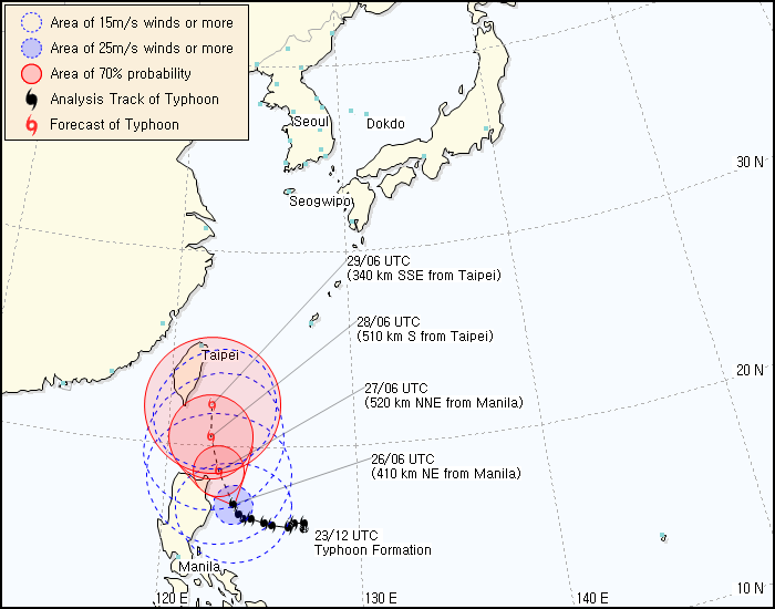
JMA sticking at 105 kt, 920 hPa.
WTPQ20 RJTD 261200
RSMC TROPICAL CYCLONE ADVISORY
NAME TY 1111 NANMADOL (1111)
ANALYSIS
PSTN 261200UTC 17.5N 123.3E GOOD
MOVE NW SLOWLY
PRES 920HPA
MXWD 105KT
GUST 150KT
50KT 100NM
30KT 200NM
FORECAST
24HF 271200UTC 19.3N 122.5E 70NM 70%
MOVE NNW SLOWLY
PRES 920HPA
MXWD 105KT
GUST 150KT
48HF 281200UTC 21.0N 122.0E 160NM 70%
MOVE NNW SLOWLY
PRES 925HPA
MXWD 100KT
GUST 140KT
72HF 291200UTC 22.3N 121.8E 220NM 70%
MOVE N SLOWLY
PRES 930HPA
MXWD 095KT
GUST 135KT =
0 likes
-
euro6208
Re: WPAC: NANMADOL - Typhoon (14W/Mina)


WOW! i just arrived home from work and i was expecting a weaker nanmadol but wow she is still maintaining a very clear well defined eye!
CI# /Pressure/ Vmax
6.8 / 920.3mb/134.8kt
Final T# Adj T# Raw T#
6.7 6.8 6.8
TPPN11 PGTW 261208
A. SUPER TYPHOON 14W (NANMADOL)
B. 26/1132Z
C. 17.6N
D. 123.3E
E. ONE/MTSAT
F. T6.5/7.0/D1.5/24HRS STT: W0.5/06HRS
G. IR/EIR
H. REMARKS: 01A/PBO EYE/ANMTN. WMG EYE SURROUNDED BY B YIELDED
A 6.5 DT. MET AND PT AGREE. DBO DT.
I. ADDITIONAL POSITIONS: NONE
QUAST
0 likes
-
RobWESTPACWX
- WestPACMet
- Posts: 1616
- Joined: Fri Sep 17, 2010 2:26 am
- Location: Tokyo, Japan
- Contact:
Re: WPAC: NANMADOL - Typhoon (14W/Mina)
To carry off of you Oaba is the fact that this storm was not expected to get so close at first, therefore if there are any evacuation orders being issued it may be to late, that is for starters, second is how many of the people in that region have the ability to evac out.
People in the states would say get on the high way and head west... That makes me think of another question along the lines of evac, but do Jeepneys offer evacuations when a storm like this approaches? (thousands of buses at disposal.)
People in the states would say get on the high way and head west... That makes me think of another question along the lines of evac, but do Jeepneys offer evacuations when a storm like this approaches? (thousands of buses at disposal.)
0 likes
Satellites, Charts and Forecasting tools for East Asia at WESTERNPACIFICWEATHER.COM
-
oaba09
- S2K Supporter

- Posts: 1496
- Age: 39
- Joined: Thu Oct 01, 2009 10:02 am
- Location: Valenzuela, Philippines
- Contact:
Re: WPAC: NANMADOL - Typhoon (14W/Mina)
RobWESTPACWX wrote:To carry off of you Oaba is the fact that this storm was not expected to get so close at first, therefore if there are any evacuation orders being issued it may be to late, that is for starters, second is how many of the people in that region have the ability to evac out.
People in the states would say get on the high way and head west... That makes me think of another question along the lines of evac, but do Jeepneys offer evacuations when a storm like this approaches? (thousands of buses at disposal.)
In our country, public schools that can't be flooded are usually used as "evac centers" because they usually have a good foundation that can withstand strong winds. The government usually uses army trucks to help w/ the evac. Unfortunately, there will always be hard headed individuals who'd rather risk their lives than risk their livelihood(farm animals, boats for fishing, etc...)
0 likes
-
dexterlabio
- Category 5

- Posts: 3506
- Joined: Sat Oct 24, 2009 11:50 pm
Re: WPAC: NANMADOL - Typhoon (14W/Mina)
The eye cleared out and seems to expand a bit...could that indicate something, or has something to do with lower DT estimates?
0 likes
Personal Forecast Disclaimer:
The posts in this forum are NOT official forecast and should not be used as such. They are just the opinion of the poster and may or may not be backed by sound meteorological data. They are NOT endorsed by any professional institution or storm2k.org. For official information, please refer to the NHC and NWS products.
The posts in this forum are NOT official forecast and should not be used as such. They are just the opinion of the poster and may or may not be backed by sound meteorological data. They are NOT endorsed by any professional institution or storm2k.org. For official information, please refer to the NHC and NWS products.
-
euro6208
Re: WPAC: NANMADOL - Typhoon (14W/Mina)
what a monster season we're having gosh, makes me wonder what the rest of the year will bring 
although the dvorak estimates have come down, i think it's misleading. i would place Super Typhoon Nanmadol's intensity at 145 knots 1 minute winds due to her very well defined clear eye embedded in a very small center of a very small typhoon. over the last few hours, she looks like she's strengthening again.
if we had recon, they would have most likely found a typhoon with a cp of 880 mb with 160 knots winds at her peak but unfortunately no recon...
The posts in this forum are NOT official forecast and should not be used as such. They are just the opinion of the poster and may or may not be backed by sound meteorological data. They are NOT endorsed by any professional institution or storm2k.org. For official information, please refer to the JTWC and JMA products.
0 likes
-
dexterlabio
- Category 5
- Posts: 3506
- Joined: Sat Oct 24, 2009 11:50 pm
Re: WPAC: NANMADOL - Typhoon (14W/Mina)
I actually noticed that looking into this satloop visible http://www.goes.noaa.gov/sohemi/sohemiloops/vsmtsatw.html
Still undeniably impressive but dangerous... I guess it's about to be on its CPA to Cagayan and Isabela, the eye's movement is quite wobbly but even if they were only just wobbles, it could already mean something for the places along its path. The city of Sta. Ana in Cagayan might just get eye-walled.
Right now, it's becoming breezy again in the metro. When I arrived home, the atmosphere turned calm but the sky was still dark. Well it seems it's gonna rain hard again, not to mention that the wind is kinda cold.
0 likes
Personal Forecast Disclaimer:
The posts in this forum are NOT official forecast and should not be used as such. They are just the opinion of the poster and may or may not be backed by sound meteorological data. They are NOT endorsed by any professional institution or storm2k.org. For official information, please refer to the NHC and NWS products.
The posts in this forum are NOT official forecast and should not be used as such. They are just the opinion of the poster and may or may not be backed by sound meteorological data. They are NOT endorsed by any professional institution or storm2k.org. For official information, please refer to the NHC and NWS products.
-
RobWESTPACWX
- WestPACMet
- Posts: 1616
- Joined: Fri Sep 17, 2010 2:26 am
- Location: Tokyo, Japan
- Contact:
I like this MIMIC loop, really shows how slow this storm has been going, and not just that the erratic movement of it
http://tropic.ssec.wisc.edu/real-time/m ... splay.html
http://tropic.ssec.wisc.edu/real-time/m ... splay.html
0 likes
Satellites, Charts and Forecasting tools for East Asia at WESTERNPACIFICWEATHER.COM
-
dexterlabio
- Category 5
- Posts: 3506
- Joined: Sat Oct 24, 2009 11:50 pm
Re:
RobWESTPACWX wrote:I like this MIMIC loop, really shows how slow this storm has been going, and not just that the erratic movement of it
http://tropic.ssec.wisc.edu/real-time/m ... splay.html
Been finding that for a long time.
By the way, does the satloop from the link I posted earlier not fixed for some reason? I don't know but it seems that the storm itself is adjusted a bit closer the land so it looks like the eye is almost off the eastern coast of Northern Luzon.
0 likes
Personal Forecast Disclaimer:
The posts in this forum are NOT official forecast and should not be used as such. They are just the opinion of the poster and may or may not be backed by sound meteorological data. They are NOT endorsed by any professional institution or storm2k.org. For official information, please refer to the NHC and NWS products.
The posts in this forum are NOT official forecast and should not be used as such. They are just the opinion of the poster and may or may not be backed by sound meteorological data. They are NOT endorsed by any professional institution or storm2k.org. For official information, please refer to the NHC and NWS products.
-
StormingB81

- S2K Supporter
- Posts: 5676
- Age: 44
- Joined: Thu Aug 27, 2009 1:45 am
- Location: Rockledge, Florida
WTPN31 PGTW 261500
MSGID/GENADMIN/NAVMARFCSTCEN PEARL HARBOR HI/JTWC//
SUBJ/TROPICAL CYCLONE WARNING//
RMKS/
1. SUPER TYPHOON 14W (NANMADOL) WARNING NR 016
02 ACTIVE TROPICAL CYCLONES IN NORTHWESTPAC
MAX SUSTAINED WINDS BASED ON ONE-MINUTE AVERAGE
WIND RADII VALID OVER OPEN WATER ONLY
---
WARNING POSITION:
261200Z --- NEAR 17.7N 123.3E
MOVEMENT PAST SIX HOURS - 330 DEGREES AT 06 KTS
POSITION ACCURATE TO WITHIN 020 NM
POSITION BASED ON EYE FIXED BY SATELLITE
PRESENT WIND DISTRIBUTION:
MAX SUSTAINED WINDS - 135 KT, GUSTS 165 KT
WIND RADII VALID OVER OPEN WATER ONLY
RADIUS OF 064 KT WINDS - 050 NM NORTHEAST QUADRANT
050 NM SOUTHEAST QUADRANT
050 NM SOUTHWEST QUADRANT
050 NM NORTHWEST QUADRANT
RADIUS OF 050 KT WINDS - 080 NM NORTHEAST QUADRANT
080 NM SOUTHEAST QUADRANT
080 NM SOUTHWEST QUADRANT
080 NM NORTHWEST QUADRANT
RADIUS OF 034 KT WINDS - 145 NM NORTHEAST QUADRANT
135 NM SOUTHEAST QUADRANT
115 NM SOUTHWEST QUADRANT
120 NM NORTHWEST QUADRANT
REPEAT POSIT: 17.7N 123.3E
---
FORECASTS:
12 HRS, VALID AT:
270000Z --- 18.8N 122.8E
MAX SUSTAINED WINDS - 140 KT, GUSTS 170 KT
WIND RADII VALID OVER OPEN WATER ONLY
RADIUS OF 064 KT WINDS - 050 NM NORTHEAST QUADRANT
050 NM SOUTHEAST QUADRANT
050 NM SOUTHWEST QUADRANT
050 NM NORTHWEST QUADRANT
RADIUS OF 050 KT WINDS - 080 NM NORTHEAST QUADRANT
080 NM SOUTHEAST QUADRANT
080 NM SOUTHWEST QUADRANT
080 NM NORTHWEST QUADRANT
RADIUS OF 034 KT WINDS - 145 NM NORTHEAST QUADRANT
140 NM SOUTHEAST QUADRANT
125 NM SOUTHWEST QUADRANT
130 NM NORTHWEST QUADRANT
VECTOR TO 24 HR POSIT: 340 DEG/ 06 KTS
---
24 HRS, VALID AT:
271200Z --- 19.9N 122.4E
MAX SUSTAINED WINDS - 145 KT, GUSTS 175 KT
WIND RADII VALID OVER OPEN WATER ONLY
RADIUS OF 064 KT WINDS - 045 NM NORTHEAST QUADRANT
045 NM SOUTHEAST QUADRANT
045 NM SOUTHWEST QUADRANT
045 NM NORTHWEST QUADRANT
RADIUS OF 050 KT WINDS - 075 NM NORTHEAST QUADRANT
075 NM SOUTHEAST QUADRANT
075 NM SOUTHWEST QUADRANT
075 NM NORTHWEST QUADRANT
RADIUS OF 034 KT WINDS - 145 NM NORTHEAST QUADRANT
135 NM SOUTHEAST QUADRANT
130 NM SOUTHWEST QUADRANT
135 NM NORTHWEST QUADRANT
VECTOR TO 36 HR POSIT: 355 DEG/ 05 KTS
---
36 HRS, VALID AT:
280000Z --- 20.9N 122.3E
MAX SUSTAINED WINDS - 140 KT, GUSTS 170 KT
WIND RADII VALID OVER OPEN WATER ONLY
RADIUS OF 064 KT WINDS - 045 NM NORTHEAST QUADRANT
045 NM SOUTHEAST QUADRANT
045 NM SOUTHWEST QUADRANT
045 NM NORTHWEST QUADRANT
RADIUS OF 050 KT WINDS - 075 NM NORTHEAST QUADRANT
075 NM SOUTHEAST QUADRANT
070 NM SOUTHWEST QUADRANT
070 NM NORTHWEST QUADRANT
RADIUS OF 034 KT WINDS - 145 NM NORTHEAST QUADRANT
140 NM SOUTHEAST QUADRANT
130 NM SOUTHWEST QUADRANT
140 NM NORTHWEST QUADRANT
VECTOR TO 48 HR POSIT: 005 DEG/ 04 KTS
---
EXTENDED OUTLOOK:
48 HRS, VALID AT:
281200Z --- 21.7N 122.4E
MAX SUSTAINED WINDS - 130 KT, GUSTS 160 KT
WIND RADII VALID OVER OPEN WATER ONLY
RADIUS OF 064 KT WINDS - 045 NM NORTHEAST QUADRANT
045 NM SOUTHEAST QUADRANT
040 NM SOUTHWEST QUADRANT
040 NM NORTHWEST QUADRANT
RADIUS OF 050 KT WINDS - 075 NM NORTHEAST QUADRANT
075 NM SOUTHEAST QUADRANT
065 NM SOUTHWEST QUADRANT
065 NM NORTHWEST QUADRANT
RADIUS OF 034 KT WINDS - 145 NM NORTHEAST QUADRANT
145 NM SOUTHEAST QUADRANT
140 NM SOUTHWEST QUADRANT
135 NM NORTHWEST QUADRANT
VECTOR TO 72 HR POSIT: 020 DEG/ 03 KTS
---
72 HRS, VALID AT:
291200Z --- 22.7N 122.8E
MAX SUSTAINED WINDS - 115 KT, GUSTS 140 KT
WIND RADII VALID OVER OPEN WATER ONLY
RADIUS OF 064 KT WINDS - 030 NM NORTHEAST QUADRANT
030 NM SOUTHEAST QUADRANT
030 NM SOUTHWEST QUADRANT
030 NM NORTHWEST QUADRANT
RADIUS OF 050 KT WINDS - 055 NM NORTHEAST QUADRANT
055 NM SOUTHEAST QUADRANT
045 NM SOUTHWEST QUADRANT
045 NM NORTHWEST QUADRANT
RADIUS OF 034 KT WINDS - 105 NM NORTHEAST QUADRANT
100 NM SOUTHEAST QUADRANT
100 NM SOUTHWEST QUADRANT
085 NM NORTHWEST QUADRANT
VECTOR TO 96 HR POSIT: 035 DEG/ 03 KTS
---
LONG RANGE OUTLOOK:
---
96 HRS, VALID AT:
301200Z --- 23.8N 123.6E
MAX SUSTAINED WINDS - 105 KT, GUSTS 130 KT
WIND RADII VALID OVER OPEN WATER ONLY
VECTOR TO 120 HR POSIT: 055 DEG/ 04 KTS
---
120 HRS, VALID AT:
311200Z --- 24.7N 125.0E
MAX SUSTAINED WINDS - 105 KT, GUSTS 130 KT
WIND RADII VALID OVER OPEN WATER ONLY
---
REMARKS:
261500Z POSITION NEAR 18.0N 123.2E.
SUPER TYPHOON 14W (NANMADOL), LOCATED APPROXIMATELY 585 NM SOUTH-
SOUTHWEST OF KADENA AB, JAPAN, HAS TRACKED NORTH-NORTHWESTWARD AT
06 KTS OVER THE PAST SIX HOURS. MAXIMUM SIGNIFICANT WAVE HEIGHT AT
261200Z IS 32 FEET. AT 082612 TYPHOON CENTER LOCATED 584 NM SSW OF
KADENA AB. NEXT WARNINGS AT 262100Z, 270300Z, 270900Z AND 271500Z.
REFER TO TROPICAL STORM 15W (TALAS) WARNINGS (WTPN32 PGTW) FOR
SIX-HOURLY UPDATES.//
NNNN
0 likes
-
StormingB81
- S2K Supporter
- Posts: 5676
- Age: 44
- Joined: Thu Aug 27, 2009 1:45 am
- Location: Rockledge, Florida

-
RobWESTPACWX
- WestPACMet
- Posts: 1616
- Joined: Fri Sep 17, 2010 2:26 am
- Location: Tokyo, Japan
- Contact:
To many people trying to get ship and Buoy obs due to all the tropical systems, so where I typically go is not working, anyone else have any other sites?
http://www.sailwx.info/shiptrack/shiplocations.phtml
http://www.sailwx.info/shiptrack/shiplocations.phtml
0 likes
Satellites, Charts and Forecasting tools for East Asia at WESTERNPACIFICWEATHER.COM
-
oaba09
- S2K Supporter
- Posts: 1496
- Age: 39
- Joined: Thu Oct 01, 2009 10:02 am
- Location: Valenzuela, Philippines
- Contact:
latest from pagasa:
Severe Weather Bulletin Number FIFTEEN
Tropical Cyclone Warning: Typhoon MINA (NANMADOL)
Issued at 11:00 p.m., Friday, 26 August 2011 Typhoon "MINA" has maintained its strength as it continues to endanger Northern Luzon.
Location of Center:
(as of 10:00 p.m.) 130 km East of Tuguegarao City
Coordinates: 17.6°N, 123.1°E
Strength: Maximum sustained winds of 195 kph near the center and Gustiness of up to 230 kph
Movement: Forecast to move Northwest at 9 kph
Forecast Positions/Outlook: Saturday evening:
110 km North Northeast of Aparri, Cagayan
Sunday evening:
70 km North of Basco, Batanes
Monday evening:
240 km North of Basco, Batanes
Areas Having Public Storm Warning Signal
Signal No. 4
( >185 kph winds)
Northern Cagayan
Calayan
Babuyan Group of Islands
Signal No.3
(100-185 kph winds)
Isabela
Rest of Cagayan
Batanes Group of Islands
Signal No. 2
(60-100 kph winds)
Northern Aurora
Quirino Ifugao
Mt. Province
Kalinga
Apayao
Signal No. 1
(45-60 kph winds)
Rest of Aurora
Nueva Vizcaya
Nueva Ecija
Benguet
La Union
Ilocos Sur
Ilocos Norte
Abra
0 likes
Who is online
Users browsing this forum: No registered users and 9 guests