ATL: IRENE - Remnants - Discussion

Moderator: S2k Moderators

Message
Author
User avatar
Dave
Retired Staff
Retired Staff
Posts: 13442
Age: 74
Joined: Tue Aug 01, 2006 3:57 pm
Location: Milan Indiana
Contact:

#4001 Postby Dave » Tue Aug 23, 2011 12:47 am

DECODED DROPSONDE 23

Code: Select all

Product: Air Force Temp Drop (Dropsonde) Message (UZNT13 KNHC)
Transmitted: 23rd day of the month at 05:40Z
Aircraft: Air Force Aircraft (Last 3 digits of the tail number are 303)
Storm Number: 09
Storm Name: Irene (flight in the North Atlantic basin)
Mission Number: 7
Observation Number: 23

Part A...


Date: Near the closest hour of 5Z on the 23rd day of the month
Highest Mandatory Level For Which Wind Was Reported: 700mb
Coordinates: 20.1N 69.6W
Location: 114 miles (183 km) to the N (10°) from Santo Domingo, Dominican Republic.
Marsden Square: 079 (About)

Level Geo. Height Air Temp. Dew Point Wind Direction Wind Speed
980mb (28.94 inHg) Sea Level (Surface) 27.2°C (81.0°F) 25.1°C (77.2°F) 135° (from the SE) 22 knots (25 mph)
1000mb -177m (-581 ft) Other data not available.
925mb 514m (1,686 ft) 23.6°C (74.5°F) 23.0°C (73.4°F) 135° (from the SE) 25 knots (29 mph)
850mb 1,253m (4,111 ft) 20.8°C (69.4°F) 19.6°C (67.3°F) 145° (from the SE) 25 knots (29 mph)
700mb 2,930m (9,613 ft) 17.0°C (62.6°F) Approximately 7°C (45°F) 90° (from the E) 13 knots (15 mph)

Information About Radiosonde:
- Launch Time: 5:24Z
- About Sonde: A descending radiosonde tracked automatically by satellite navigation with no solar or infrared correction.

Remarks Section...


Dropsonde Location: Dropped in eye.

Splash Location: 20.13N 69.63W
Splash Time: 5:29Z

Release Location: 20.12N 69.62W View map)
Release Time: 5:24:45Z

Splash Location: 20.13N 69.63W (
Splash Time: 5:28:43Z

Mean Boundary Level Wind (mean wind in the lowest 500 geopotential meters of the sounding):
- Wind Direction: 145° (from the SE)
- Wind Speed: 24 knots (28 mph)

Deep Layer Mean Wind (average wind over the depth of the sounding):
- Wind Direction: 135° (from the SE)
- Wind Speed: 19 knots (22 mph)
- Depth of Sounding: From 697mb to 980mb

Average Wind Over Lowest Available 150 geopotential meters (gpm) of the sounding:
- Lowest 150m: 158 gpm - 8 gpm (518 geo. feet - 26 geo. feet)
- Wind Direction: 145° (from the SE)
- Wind Speed: 23 knots (26 mph)

Sounding Software Version: AEV 20802


Part B: Data For Significant Levels...


Significant Temperature And Relative Humidity Levels...
Level Air Temperature Dew Point
980mb (Surface) 27.2°C (81.0°F) 25.1°C (77.2°F)
919mb 23.2°C (73.8°F) 22.7°C (72.9°F)
850mb 20.8°C (69.4°F) 19.6°C (67.3°F)
810mb 18.4°C (65.1°F) 17.5°C (63.5°F)
790mb 19.8°C (67.6°F) 15.8°C (60.4°F)
788mb 19.8°C (67.6°F) 15.7°C (60.3°F)
766mb 20.4°C (68.7°F) Approximately 13°C (55°F)
712mb 17.8°C (64.0°F) Approximately 11°C (52°F)
697mb 16.8°C (62.2°F) Approximately 6°C (43°F)

Significant Wind Levels...
Level Wind Direction Wind Speed
980mb (Surface) 135° (from the SE) 22 knots (25 mph)
944mb 150° (from the SSE) 28 knots (32 mph)
936mb 145° (from the SE) 23 knots (26 mph)
915mb 135° (from the SE) 26 knots (30 mph)
901mb 135° (from the SE) 22 knots (25 mph)
870mb 145° (from the SE) 30 knots (35 mph)
850mb 145° (from the SE) 25 knots (29 mph)
801mb 140° (from the SE) 15 knots (17 mph)
760mb 90° (from the E) 15 knots (17 mph)
697mb 90° (from the E) 13 knots (15 mph)


---

0 likes   
This post is NOT AN OFFICIAL FORECAST and should not be used as such. It is just the opinion of the poster and may or may not be backed by sound meteorological data. It is NOT endorsed by any professional institution including storm2k.org. For Official Information please refer to the NHC and NWS products.

User avatar
Dave
Retired Staff
Retired Staff
Posts: 13442
Age: 74
Joined: Tue Aug 01, 2006 3:57 pm
Location: Milan Indiana
Contact:

#4002 Postby Dave » Tue Aug 23, 2011 12:48 am

Image
0 likes   
This post is NOT AN OFFICIAL FORECAST and should not be used as such. It is just the opinion of the poster and may or may not be backed by sound meteorological data. It is NOT endorsed by any professional institution including storm2k.org. For Official Information please refer to the NHC and NWS products.

User avatar
Dave
Retired Staff
Retired Staff
Posts: 13442
Age: 74
Joined: Tue Aug 01, 2006 3:57 pm
Location: Milan Indiana
Contact:

#4003 Postby Dave » Tue Aug 23, 2011 12:48 am

000
URNT12 KNHC 230546
VORTEX DATA MESSAGE AL092011
A. 23/05:18:00Z
B. 20 deg 06 min N
069 deg 38 min W
C. 700 mb 2942 m
D. 59 kt
E. 260 deg 11 nm
F. 009 deg 47 kt
G. 272 deg 52 nm
H. 980 mb
I. 8 C / 3052 m
J. 19 C / 3045 m
K. NA / NA
L. OPEN W
M. C24
N. 12345 / 7
O. 0.02 / 3 nm
P. AF303 0709A IRENE OB 22
MAX FL WIND 83 KT NE QUAD 04:09:50Z
MAX OUTBOUND FL WIND 75 KT E QUAD 05:30:30Z
0 likes   

supercane
S2K Supporter
S2K Supporter
Posts: 2858
Joined: Wed Sep 16, 2009 8:27 pm

#4004 Postby supercane » Tue Aug 23, 2011 12:48 am

000
WTNT34 KNHC 230546
TCPAT4

BULLETIN
HURRICANE IRENE INTERMEDIATE ADVISORY NUMBER 11A
NWS NATIONAL HURRICANE CENTER MIAMI FL AL092011
200 AM AST TUE AUG 23 2011

...CENTER OF IRENE JUST NORTHEAST OF THE DOMINICAN REPUBLIC...
EXPECTED TO MOVE OVER THE SOUTHEASTERN BAHAMAS LATER TODAY...


SUMMARY OF 200 AM AST...0600 UTC...INFORMATION
----------------------------------------------
LOCATION...20.1N 69.7W
ABOUT 135 MI...215 KM SE OF GRAND TURK ISLAND
ABOUT 70 MI...110 KM ENE OF PUERTO PLATA DOMINICAN REPUBLIC
MAXIMUM SUSTAINED WINDS...100 MPH...160 KM/H
PRESENT MOVEMENT...WNW OR 295 DEGREES AT 12 MPH...19 KM/H
MINIMUM CENTRAL PRESSURE...978 MB...28.88 INCHES


WATCHES AND WARNINGS
--------------------
CHANGES IN WATCHES AND WARNINGS WITH THIS ADVISORY...

NONE.

SUMMARY OF WATCHES AND WARNINGS IN EFFECT...

A HURRICANE WARNING IS IN EFFECT FOR...
* NORTH COAST OF THE DOMINICAN REPUBLIC FROM THE HAITI BORDER
EASTWARD TO CABO ENGANO
* TURKS AND CAICOS ISLANDS...SOUTHEASTERN AND CENTRAL BAHAMAS

A HURRICANE WATCH IS IN EFFECT FOR...
* NORTH COAST OF HAITI FROM LE MOLE ST. NICHOLAS EASTWARD TO THE
DOMINICAN REPUBLIC BORDER
* NORTHWESTERN BAHAMAS

A TROPICAL STORM WARNING IS IN EFFECT FOR...
* SOUTH COAST OF THE DOMINICAN REPUBLIC FROM SANTO DOMINGO EASTWARD
TO CABO ENGANO
* ALL OF HAITI

FOR STORM INFORMATION SPECIFIC TO YOUR AREA...PLEASE MONITOR
PRODUCTS ISSUED BY YOUR NATIONAL METEOROLOGICAL SERVICE.


DISCUSSION AND 48-HOUR OUTLOOK
------------------------------
AT 200 AM AST...0600 UTC...THE CENTER OF HURRICANE IRENE WAS
LOCATED BY AN AIR FORCE RESERVE HURRICANE HUNTER AIRCRAFT NEAR
LATITUDE 20.1 NORTH...LONGITUDE 69.7 WEST. IRENE IS MOVING TOWARD
THE WEST-NORTHWEST NEAR 12 MPH...19 KM/H. THIS MOTION IS EXPECTED
TO CONTINUE THROUGH TODAY...FOLLOWED BY A TURN TOWARD THE NORTHWEST
TUESDAY NIGHT AND WEDNESDAY. ON THE FORECAST TRACK...THE CORE OF
IRENE WILL PASS TO THE NORTH OF THE DOMINICAN REPUBLIC AND HAITI
THIS MORNING...NEAR OR OVER THE TURKS AND CAICOS ISLANDS AND THE
SOUTHEASTERN BAHAMAS BY TONIGHT...AND BE NEAR THE CENTRAL BAHAMAS
EARLY WEDNESDAY.

DATA FROM THE HURRICANE HUNTER AIRCRAFT INDICATE THAT MAXIMUM
SUSTAINED WINDS REMAIN NEAR 100 MPH...160 KM/H...WITH HIGHER
GUSTS. IRENE IS A CATEGORY TWO HURRICANE ON THE SAFFIR-SIMPSON
HURRICANE WIND SCALE. ADDITIONAL STRENGTHENING IS FORECAST DURING
THE NEXT 48 HOURS...AND IRENE COULD BECOME A MAJOR HURRICANE ON
LATER TODAY.

HURRICANE-FORCE WINDS EXTEND OUTWARD UP TO 45 MILES...75 KM...FROM
THE CENTER...AND TROPICAL-STORM-FORCE WINDS EXTEND OUTWARD UP TO
185 MILES...295 KM.

THE MINIMUM CENTRAL PRESSURE BASED ON DATA FROM THE HURRICANE HUNTER
AIRCRAFT IS 978 MB...28.88 INCHES.


HAZARDS AFFECTING LAND
----------------------
WIND...TROPICAL STORM CONDITIONS WILL CONTINUE TO SPREAD OVER THE
NORTHERN PORTIONS OF DOMINICAN REPUBLIC TONIGHT...AND LOCALIZED
HURRICANE CONDITIONS ARE EXPECTED OVER THE NORTHERN PORTIONS OF THE
DOMINICAN REPUBLIC THIS MORNING. THE HIGHEST WINDS ARE LIKELY TO
OCCUR OVER AREAS OF ELEVATED TERRAIN. TROPICAL STORM CONDITIONS
ARE EXPECTED TO REACH THE SOUTHEASTERN BAHAMAS AND THE TURKS AND
CAICOS ISLANDS LATER THIS MORNING WITH HURRICANE CONDITIONS
EXPECTED BY THIS AFTERNOON AND EVENING. TROPICAL STORM CONDITIONS
ARE EXPECTED TO REACH THE CENTRAL BAHAMAS LATE TONIGHT WITH
HURRICANE CONDITIONS EXPECTED BY WEDNESDAY. TROPICAL STORM
CONDITIONS ARE POSSIBLE IN THE NORTHWESTERN BAHAMAS BY LATE
WEDNESDAY...WITH HURRICANE CONDITIONS POSSIBLE BY THURSDAY.

RAINFALL...IRENE IS EXPECTED TO PRODUCE ADDITIONAL RAINFALL
ACCUMULATIONS OF 1 TO 2 INCHES ACROSS PUERTO RICO AND THE VIRGIN
ISLANDS. RAINFALL AMOUNTS OF 3 TO 6 INCHES ARE EXPECTED OVER
NORTHERN HISPANIOLA...WITH ISOLATED MAXIMUM AMOUNTS OF UP TO 10
INCHES POSSIBLE OVER HIGHER TERRAIN. THESE RAINS COULD CAUSE
LIFE-THREATENING FLASH FLOODS AND MUDSLIDES IN AREAS OF STEEP
TERRAIN. RAINFALL ACCUMULATIONS OF 5 TO 10 INCHES ARE EXPECTED IN
THE SOUTHEASTERN AND CENTRAL BAHAMAS...AND THE TURKS AND CAICOS
ISLANDS.

STORM SURGE...A STORM SURGE WILL RAISE WATER LEVELS BY AS MUCH AS
9 TO 13 FEET ABOVE NORMAL TIDE LEVELS OVER THE SOUTHEASTERN AND
CENTRAL BAHAMAS...AND THE TURKS AND CAICOS ISLANDS. STORM SURGE
WILL ALSO RAISE WATER LEVELS BY AS MUCH AS 2 TO 4 FEET ABOVE NORMAL
TIDE LEVELS ALONG THE ENTIRE COAST OF THE DOMINICAN REPUBLIC. NEAR
THE COAST...THE SURGE WILL BE ACCOMPANIED BY LARGE AND DANGEROUS
WAVES.


NEXT ADVISORY
-------------
NEXT COMPLETE ADVISORY...500 AM AST.

$$
FORECASTER STEWART
0 likes   

User avatar
WxGuy1
Professional-Met
Professional-Met
Posts: 538
Joined: Sat Oct 22, 2005 12:55 pm
Location: Oklahoma

Re: ATL: IRENE - Hurricane - Discussion

#4005 Postby WxGuy1 » Tue Aug 23, 2011 12:48 am

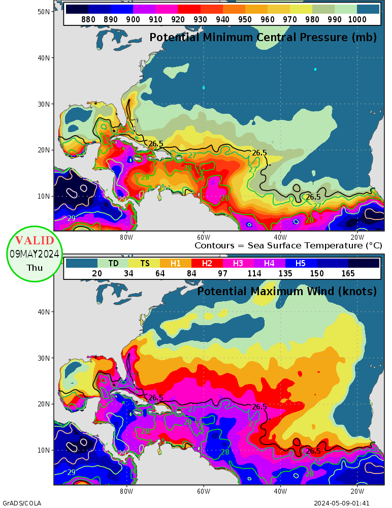
This certainly could be a bad experience for the New England area, but we're still seeing model runs with rather wide variability of landfall location. I thought I read something about worries about the areas north of Maryland. Just to note: For what it's worth, the current Maximum Potential Intensitybarely supports a 980-990 mb Cat 1 hurricane into the Long Island area. Since hurricanes rarely are at their MPI, this should give *some* comfort to residents of those areas. The MPI shows a 930 mb Cat 4 is possible as north as the VA/NC border. The conditions will change in 4-5 days when Irene approaches those areas, but I wouldn't expect a 920 mb Cat 4 to rake the coastline from South Carolina to Long Island.

Image
0 likes   


User avatar
Dave
Retired Staff
Retired Staff
Posts: 13442
Age: 74
Joined: Tue Aug 01, 2006 3:57 pm
Location: Milan Indiana
Contact:

#4007 Postby Dave » Tue Aug 23, 2011 12:50 am

DECODED VDM OB 22

Product: Air Force Vortex Message (URNT12 KNHC)
Transmitted: 23rd day of the month at 05:46Z
Aircraft: Air Force Aircraft (Last 3 digits of the tail number are 303)
Storm Number & Year: 09L in 2011
Storm Name: Irene (flight in the North Atlantic basin)
Mission Number: 7
Observation Number: 22
A. Time of Center Fix: 23rd day of the month at 5:18:00Z
B. Center Fix Coordinates: 20°06'N 69°38'W (20.1N 69.6333W)
B. Center Fix Location: 113 miles (182 km) to the N (9°) from Santo Domingo, Dominican Republic.
C. Minimum Height at Standard Level: 2,942m (9,652ft) at 700mb
D. Estimated (by SFMR or visually) Maximum Surface Wind: 59kts (~ 67.9mph)
E. Location of the Estimated Maximum Surface Wind: 11 nautical miles (13 statute miles) to the W (260°) of center fix
F. Maximum Flight Level Wind Inbound: From 9° at 47kts (From the N at ~ 54.1mph)
G. Location of Maximum Flight Level Wind Inbound: 52 nautical miles (60 statute miles) to the W (272°) of center fix
H. Minimum Sea Level Pressure: 980mb (28.94 inHg)
I. Maximum Flight Level Temp & Pressure Altitude Outside Eye: 8°C (46°F) at a pressure alt. of 3,052m (10,013ft)
J. Maximum Flight Level Temp & Pressure Altitude Inside Eye: 19°C (66°F) at a pressure alt. of 3,045m (9,990ft)
K. Dewpoint Temp & Sea Surface Temp (collected at same location as temp inside eye): Not Available
L. Eye Character: Open in the west
M. Eye Shape & Diameter: Circular with a diameter of 24 nautical miles (28 statute miles)
N. Fix Determined By: Penetration, Radar, Wind, Pressure and Temperature
N. Fix Level: 700mb
O. Navigation Fix Accuracy: 0.02 nautical miles
O. Meteorological Accuracy: 3 nautical miles
Remarks Section:
Maximum Flight Level Wind: 83kts (~ 95.5mph) in the northeast quadrant at 4:09:50Z
Maximum Flight Level Wind Outbound: 75kts (~ 86.3mph) in the east quadrant at 5:30:30Z
0 likes   
This post is NOT AN OFFICIAL FORECAST and should not be used as such. It is just the opinion of the poster and may or may not be backed by sound meteorological data. It is NOT endorsed by any professional institution including storm2k.org. For Official Information please refer to the NHC and NWS products.

RL3AO
Moderator-Pro Met
Moderator-Pro Met
Posts: 16308
Joined: Thu Jun 14, 2007 10:03 pm
Location: NC

Re: ATL: IRENE - Hurricane - Discussion

#4008 Postby RL3AO » Tue Aug 23, 2011 12:51 am

bamajammer4eva wrote:Meteorologist in Florida just said Irene has been taking a westward turn tonight and that would have occurred since the 00z models were initiated so some concern it may trend back toward FL.


Thats not what recon shows. Solid 295 wnw movement.
0 likes   

User avatar
Dave
Retired Staff
Retired Staff
Posts: 13442
Age: 74
Joined: Tue Aug 01, 2006 3:57 pm
Location: Milan Indiana
Contact:

#4009 Postby Dave » Tue Aug 23, 2011 12:52 am

851
URNT15 KNHC 230551
AF303 0709A IRENE HDOB 47 20110823
054100 1940N 06859W 6971 03108 //// +102 //// 205045 046 039 002 01
054130 1939N 06858W 6971 03112 //// +104 //// 204044 044 039 001 01
054200 1938N 06856W 6970 03116 //// +101 //// 203043 043 039 000 01
054230 1937N 06855W 6967 03120 //// +096 //// 202041 041 039 001 01
054300 1936N 06854W 6973 03116 //// +099 //// 204041 041 038 001 01
054330 1934N 06852W 6955 03142 //// +102 //// 201041 041 037 001 01
054400 1933N 06851W 6968 03132 //// +101 //// 201038 039 036 000 01
054430 1931N 06849W 6974 03125 //// +100 //// 200036 036 035 000 01
054500 1930N 06847W 6971 03130 //// +101 //// 203035 035 034 000 01
054530 1929N 06846W 6970 03132 //// +096 //// 204036 038 033 000 01
054600 1927N 06844W 6974 03129 //// +098 //// 201037 038 033 000 01
054630 1926N 06842W 6970 03133 //// +099 //// 201038 038 033 000 01
054700 1924N 06840W 6973 03131 //// +099 //// 198039 040 033 000 01
054730 1923N 06839W 6970 03138 //// +092 //// 200040 041 036 000 01
054800 1921N 06837W 6970 03133 //// +081 //// 204039 040 038 000 01
054830 1920N 06835W 6983 03122 //// +089 //// 206037 037 036 000 01
054900 1919N 06834W 6968 03142 //// +086 //// 204037 037 038 000 01
054930 1917N 06832W 6969 03142 //// +090 //// 206035 036 036 000 01
055000 1916N 06830W 6973 03138 //// +092 //// 206035 035 039 000 01
055030 1914N 06829W 6973 03139 //// +095 //// 205036 036 038 000 01
$$
;
0 likes   
This post is NOT AN OFFICIAL FORECAST and should not be used as such. It is just the opinion of the poster and may or may not be backed by sound meteorological data. It is NOT endorsed by any professional institution including storm2k.org. For Official Information please refer to the NHC and NWS products.

User avatar
Dave
Retired Staff
Retired Staff
Posts: 13442
Age: 74
Joined: Tue Aug 01, 2006 3:57 pm
Location: Milan Indiana
Contact:

#4010 Postby Dave » Tue Aug 23, 2011 12:58 am

Image
0 likes   
This post is NOT AN OFFICIAL FORECAST and should not be used as such. It is just the opinion of the poster and may or may not be backed by sound meteorological data. It is NOT endorsed by any professional institution including storm2k.org. For Official Information please refer to the NHC and NWS products.

maxintensity
Tropical Storm
Tropical Storm
Posts: 165
Joined: Tue Aug 02, 2011 9:54 pm

Re: ATL: IRENE - Hurricane - Discussion

#4011 Postby maxintensity » Tue Aug 23, 2011 12:59 am

WxGuy1 wrote:This certainly could be a bad experience for the New England area, but we're still seeing model runs with rather wide variability of landfall location. I thought I read something about worries about the areas north of Maryland. Just to note: For what it's worth, the current Maximum Potential Intensitybarely supports a 980-990 mb Cat 1 hurricane into the Long Island area. Since hurricanes rarely are at their MPI, this should give *some* comfort to residents of those areas. The MPI shows a 930 mb Cat 4 is possible as north as the VA/NC border. The conditions will change in 4-5 days when Irene approaches those areas, but I wouldn't expect a 920 mb Cat 4 to rake the coastline from South Carolina to Long Island.

Image
From the developer of the method "Hurricanes cannot be expected to develop where the potential intensity estimate is small or zero; but storms moving rapidly from regions of high potential intensity to regions of low intensity can be expected to maintain strength well in excess of the local potential intensity estimate. "
0 likes   

User avatar
PTrackerLA
Category 5
Category 5
Posts: 5277
Age: 41
Joined: Thu Oct 10, 2002 8:40 pm
Location: Lafayette, LA

Re: ATL: IRENE - Hurricane - Discussion

#4012 Postby PTrackerLA » Tue Aug 23, 2011 12:59 am

[quote="SNOW_JOKE"]Daily Atlantic SST temps
http://www.wunderground.com/tropical/?index_region=at

OT: Wow look at the heat in the gulf. We better hope that doesn't get tapped this season.

Looks like a cat 3 could be sustainable to Long Island according to that map but I would think cat 2 tops.
0 likes   

User avatar
fci
S2K Supporter
S2K Supporter
Posts: 3324
Joined: Tue Sep 14, 2004 10:29 am
Location: Lake Worth, FL

Re: ATL: IRENE - Hurricane - Discussion

#4013 Postby fci » Tue Aug 23, 2011 1:01 am


I watched his update on the video and I didn't hear him say anything about a trend towards Florida. Did you link the wrong clip?
0 likes   

User avatar
Dave
Retired Staff
Retired Staff
Posts: 13442
Age: 74
Joined: Tue Aug 01, 2006 3:57 pm
Location: Milan Indiana
Contact:

#4014 Postby Dave » Tue Aug 23, 2011 1:03 am

338
URNT15 KNHC 230601
AF303 0709A IRENE HDOB 48 20110823
055100 1913N 06827W 6967 03148 //// +092 //// 204036 037 039 000 01
055130 1911N 06825W 6975 03137 //// +090 //// 202037 038 039 000 05
055200 1910N 06824W 6971 03146 //// +088 //// 198040 042 040 000 05
055230 1909N 06822W 6975 03142 //// +090 //// 196043 043 039 000 05
055300 1907N 06821W 6966 03152 //// +090 //// 201042 043 036 000 01
055330 1906N 06819W 6971 03146 //// +090 //// 201041 041 036 000 05
055400 1905N 06817W 6971 03149 //// +090 //// 200039 039 036 000 01
055430 1903N 06816W 6974 03144 //// +087 //// 198038 039 035 002 01
055500 1902N 06814W 6989 03129 //// +068 //// 194036 038 037 003 01
055530 1901N 06813W 6975 03143 //// +081 //// 193037 038 034 002 01
055600 1859N 06811W 6969 03151 //// +085 //// 192036 036 031 001 01
055630 1858N 06810W 6973 03145 //// +087 //// 193032 034 029 001 01
055700 1857N 06809W 6969 03153 //// +088 //// 191031 033 027 002 01
055730 1856N 06807W 6722 03459 //// +075 //// 190033 034 /// /// 05
055800 1855N 06806W 6447 03802 //// +056 //// 197032 033 030 004 05
055830 1854N 06805W 6196 04131 //// +030 //// 206034 035 030 005 05
055900 1853N 06803W 5931 04459 //// +016 //// 200037 040 029 005 05
055930 1852N 06802W 5743 04725 //// +004 //// 205027 029 031 005 01
060000 1850N 06801W 5563 04997 //// -002 //// 212027 030 030 005 05
060030 1849N 06759W 5409 05221 0231 -011 //// 222032 033 029 006 05
$$
;


Mission over...taking this buggy to the barn!
0 likes   
This post is NOT AN OFFICIAL FORECAST and should not be used as such. It is just the opinion of the poster and may or may not be backed by sound meteorological data. It is NOT endorsed by any professional institution including storm2k.org. For Official Information please refer to the NHC and NWS products.

User avatar
WxEnthus
Category 1
Category 1
Posts: 261
Joined: Thu Jun 09, 2011 9:33 am
Location: Eastern U.S.

Re: ATL: IRENE - Hurricane - Discussion

#4015 Postby WxEnthus » Tue Aug 23, 2011 1:06 am

SNOW_JOKE wrote:Daily Atlantic SST temps
http://www.wunderground.com/tropical/?index_region=at

Image

Uploaded with ImageShack.us


Yowzers, look at the water temps all the way up the eastern coast! I don't understand why some folks on tv are sounding so sure that if it landfalls higher up the coast than FL it won't be more than a CAT 1 or 2. What's stopping it from strengthening or at least maintaining it's intensity to SC/NC as it runs up the very warm waters of the gulf stream? Are there atmospheric factors that would weaken it?
0 likes   
    Disclaimer: Posts herein are my amateur opinion only and should not be used for making important decisions. Defer to the NHC, NWS, and local authorities for official guidance.

User avatar
Dave
Retired Staff
Retired Staff
Posts: 13442
Age: 74
Joined: Tue Aug 01, 2006 3:57 pm
Location: Milan Indiana
Contact:

#4016 Postby Dave » Tue Aug 23, 2011 1:07 am

Wide area view....

Image
0 likes   
This post is NOT AN OFFICIAL FORECAST and should not be used as such. It is just the opinion of the poster and may or may not be backed by sound meteorological data. It is NOT endorsed by any professional institution including storm2k.org. For Official Information please refer to the NHC and NWS products.

User avatar
Dave
Retired Staff
Retired Staff
Posts: 13442
Age: 74
Joined: Tue Aug 01, 2006 3:57 pm
Location: Milan Indiana
Contact:

#4017 Postby Dave » Tue Aug 23, 2011 1:10 am

Next mission...this morning...

HURRICANE IRENE
FLIGHT ONE -- TEAL 73
A. 23/12Z,18Z
B. AFXXX 0809A IRENE
C. 23/1015Z
D. 20.5N 71.4W
E. 23/1130Z TO 23/18Z
F. SFC TO 10,000 FT
0 likes   
This post is NOT AN OFFICIAL FORECAST and should not be used as such. It is just the opinion of the poster and may or may not be backed by sound meteorological data. It is NOT endorsed by any professional institution including storm2k.org. For Official Information please refer to the NHC and NWS products.

bamajammer4eva
Category 4
Category 4
Posts: 907
Joined: Sun Apr 18, 2010 3:21 am
Location: Ozark, AL

Re: ATL: IRENE - Hurricane - Discussion

#4018 Postby bamajammer4eva » Tue Aug 23, 2011 1:21 am

fci wrote:
bamajammer4eva wrote:Meteorologist in Florida just said Irene has been taking a westward turn tonight and that would have occurred since the 00z models were initiated so some concern it may trend back toward FL.


I watched his update on the video and I didn't hear him say anything about a trend towards Florida. Did you link the wrong clip?


Clip says ovenite with Irene or something like that-link works for me but not sure. I would think that's what he meant being he is in Florida and he said the westward jog had him concerned. Perhaps he has property in Bermuda and the westward jog may turn the models east but I wouldn't think he would be telling everyone in Florida that to worry them unnecessarily.
0 likes   

User avatar
x-y-no
Category 5
Category 5
Posts: 8359
Age: 65
Joined: Wed Aug 11, 2004 12:14 pm
Location: Fort Lauderdale, FL

Re: ATL: IRENE - Hurricane - Discussion

#4019 Postby x-y-no » Tue Aug 23, 2011 1:37 am

Pronounced dry slot off the DR mountains getting wrapped in - cloud tops warming some:

Image
0 likes   

User avatar
TwisterFanatic
Category 5
Category 5
Posts: 1041
Joined: Mon Jun 28, 2010 12:43 pm
Location: Sallisaw, Oklahoma

#4020 Postby TwisterFanatic » Tue Aug 23, 2011 1:38 am

Wow! Look at that outflow on the West side, perfect.
0 likes   
Personal Forecast Disclaimer:
The posts in this forum are NOT official forecast and should not be used as such. They are just the opinion of the poster and may or may not be backed by sound meteorological data. They are NOT endorsed by any professional institution or storm2k.org. For official information, please refer to the NHC and NWS products.


Return to “2011”

Who is online

Users browsing this forum: No registered users and 13 guests