

ATL: INVEST 94L - DISCUSSION
Moderator: S2k Moderators
Re: ATL: INVEST 94L - DISCUSSION
CAPE has been consistent for the last few days here; running around 2200.
0 likes

Re: ATL: INVEST 94L - DISCUSSION
GCANE wrote:RUC sounding near NHC's tagged COC shows air saturated thru about 500mb.
http://www.twisterdata.com/data/tmp/scr ... .0000W.png
COC is near 81-82W not 78W, you keep thinking that the area south of Jamaica is where the surface COC is, but is not.
Code: Select all
Best Track Position and Intensity as of:

Monday, June 6, 2011 6:00 Z

Location at the time:

154 statue miles (249 km) to the S (171°) from George Town, Cayman Islands (GBR).

Wind (1 min. avg.):

25 knots (~29 mph | 13 m/s | 46 km/h)

Pressure:

1007 mb (29.74 inHg | 1007 hPa)

Coordinates:

17.1N 81W

Source:

National Hurricane Center's (NHC)
Automated Tropical Cyclone Forecasting System (ATCF)
0 likes
Re: ATL: INVEST 94L - DISCUSSION
TROPICAL WEATHER OUTLOOK
NWS NATIONAL HURRICANE CENTER MIAMI FL
800 AM EDT MON JUN 6 2011
FOR THE NORTH ATLANTIC...CARIBBEAN SEA AND THE GULF OF MEXICO...
A LARGE BUT DISORGANIZED AREA OF SHOWERS AND THUNDERSTORMS
ASSOCIATED WITH A BROAD LOW PRESSURE SYSTEM CONTINUES OVER MUCH OF
THE CENTRAL AND WESTERN CARIBBEAN SEA. THE AREA OF LOWEST PRESSURE
IS LOCATED ABOUT 130 MILES SOUTH OF GRAND CAYMAN AND REMAINS
SEPARATED FROM THE STRONGEST THUNDERSTORM ACTIVITY. HOWEVER...SOME
DEVELOPMENT OF THIS SYSTEM IS POSSIBLE DURING THE NEXT DAY OR SO
BEFORE UPPER-LEVEL WINDS BECOME UNFAVORABLE. THERE IS A MEDIUM
CHANCE...40 PERCENT...OF THIS SYSTEM BECOMING A TROPICAL CYCLONE
DURING THE NEXT 48 HOURS. AN AIR FORCE RESERVE HURRICANE HUNTER
AIRCRAFT MISSION HAS BEEN RESCHEDULED TO INVESTIGATE THE SYSTEM
TOMORROW...IF NECESSARY. REGARDLESS OF DEVELOPMENT...HEAVY RAINS
COULD CAUSE FLASH FLOODS AND MUD SLIDES OVER PORTIONS OF HAITI AND
JAMAICA AS THE SYSTEM MOVES SLOWLY TOWARD THE NORTHWEST OR NORTH
OVER THE NEXT COUPLE OF DAYS.
ELSEWHERE...TROPICAL CYCLONE FORMATION IS NOT EXPECTED DURING THE
NEXT 48 HOURS.
$$
FORECASTER STEWART
0 likes
-
cycloneye

- Admin

- Posts: 149368
- Age: 69
- Joined: Thu Oct 10, 2002 10:54 am
- Location: San Juan, Puerto Rico
Re: ATL: INVEST 94L - RECON
Recon RESCHEDULED for tommorow
TROPICAL WEATHER OUTLOOK
NWS NATIONAL HURRICANE CENTER MIAMI FL
800 AM EDT MON JUN 6 2011
FOR THE NORTH ATLANTIC...CARIBBEAN SEA AND THE GULF OF MEXICO...
A LARGE BUT DISORGANIZED AREA OF SHOWERS AND THUNDERSTORMS
ASSOCIATED WITH A BROAD LOW PRESSURE SYSTEM CONTINUES OVER MUCH OF
THE CENTRAL AND WESTERN CARIBBEAN SEA. THE AREA OF LOWEST PRESSURE
IS LOCATED ABOUT 130 MILES SOUTH OF GRAND CAYMAN AND REMAINS
SEPARATED FROM THE STRONGEST THUNDERSTORM ACTIVITY. HOWEVER...SOME
DEVELOPMENT OF THIS SYSTEM IS POSSIBLE DURING THE NEXT DAY OR SO
BEFORE UPPER-LEVEL WINDS BECOME UNFAVORABLE. THERE IS A MEDIUM
CHANCE...40 PERCENT...OF THIS SYSTEM BECOMING A TROPICAL CYCLONE
DURING THE NEXT 48 HOURS. AN AIR FORCE RESERVE HURRICANE HUNTER
AIRCRAFT MISSION HAS BEEN RESCHEDULED TO INVESTIGATE THE SYSTEM
TOMORROW...IF NECESSARY. REGARDLESS OF DEVELOPMENT...HEAVY RAINS
COULD CAUSE FLASH FLOODS AND MUD SLIDES OVER PORTIONS OF HAITI AND
JAMAICA AS THE SYSTEM MOVES SLOWLY TOWARD THE NORTHWEST OR NORTH
OVER THE NEXT COUPLE OF DAYS.
ELSEWHERE...TROPICAL CYCLONE FORMATION IS NOT EXPECTED DURING THE
NEXT 48 HOURS.
$$
FORECASTER STEWART
0 likes
Visit the Caribbean-Central America Weather Thread where you can find at first post web cams,radars
and observations from Caribbean basin members Click Here
and observations from Caribbean basin members Click Here
Re: ATL: INVEST 94L - DISCUSSION
NDG wrote:
COC is near 81-82W not 78W, you keep thinking that the area south of Jamaica is where the surface COC is, but is not.
Trouble with RUC is I can't that far south and west at same time.
0 likes
-
cycloneye
- Admin
- Posts: 149368
- Age: 69
- Joined: Thu Oct 10, 2002 10:54 am
- Location: San Juan, Puerto Rico
Re: ATL: INVEST 94L - DISCUSSION
Arlene will have to wait as the window for 94L to develop is almost closed. Here is the GFS shear graphic for the next 5 days.

0 likes
Visit the Caribbean-Central America Weather Thread where you can find at first post web cams,radars
and observations from Caribbean basin members Click Here
and observations from Caribbean basin members Click Here

Re: ATL: INVEST 94L - DISCUSSION
It smells like rain here in Fort Lauderdale this morning - also, contrary to this past week there's an arrival of numerous low clouds this morning, so apparently our rainy season is about to start in ernest, and that's good - nothing worse than being hot and dry...
I won't mind if Arlene doesn't form, but it'd be nice to get the rain associated with the disturbance...
Frank
I won't mind if Arlene doesn't form, but it'd be nice to get the rain associated with the disturbance...
Frank
0 likes

12z SHIPS does not like 94L's chances despite high OHC numbers. Shear will remain moderate through five days and is probably not helping.
Code: Select all
                    *   ATLANTIC SHIPS INTENSITY FORECAST       *
                    * GOES AVAILABLE,       OHC AVAILABLE       *
                    *      INVEST  AL942011  06/06/11  12 UTC   *

TIME (HR)          0     6    12    18    24    36    48    60    72    84    96   108   120
V (KT) NO LAND    25    26    27    28    28    27    23    18   DIS   DIS   DIS   DIS   DIS
V (KT) LAND       25    26    27    28    28    27    23    18   DIS   DIS   DIS   DIS   DIS
V (KT) LGE mod    25    25    26    26    26    25    23    19    15   DIS   DIS   DIS   DIS

SHEAR (KT)        10    13    21    26    27    35    46    50    40    35    26    23    24
SHEAR ADJ (KT)    -5     0     3     5     5     2     5     4     4    10     4     4     0
SHEAR DIR        244   226   220   231   238   238   252   240   239   228   259   260   274
SST (C)         28.3  28.2  28.2  28.2  28.3  28.3  28.4  28.6  28.4  28.2  28.0  27.9  27.9
POT. INT. (KT)   139   136   136   135   137   138   140   144   141   137   134   133   133
ADJ. POT. INT.   127   123   121   120   122   123   126   129   125   120   117   116   115
200 MB T (C)   -52.9 -52.5 -52.3 -52.5 -52.7 -52.4 -53.2 -52.5 -52.7 -51.5 -51.3 -50.4 -49.9
TH_E DEV (C)       7     8     9     8     8     9     8     9     9     9     9    10     9
700-500 MB RH     68    67    68    68    69    66    62    64    64    54    48    45    42
GFS VTEX (KT)     10     9     9     9     7     7     6     6     6     9     8     7     5
850 MB ENV VOR    84    87    94    84    77    83    59    61    41    49    33    27    -8
200 MB DIV        59    67    81    77    49    59    43    52    23    30   -15   -40   -17
700-850 TADV       0     0     0     0     0     2     2     5     4     4     5     3     7
LAND (KM)        345   353   363   369   376   341   254   117     4    75   170   296   397
LAT (DEG N)     17.7  18.0  18.3  18.5  18.6  19.1  19.8  20.9  22.1  23.1  23.7  24.5  25.1
LONG(DEG W)     81.6  81.8  82.0  82.1  82.2  82.5  83.0  83.6  84.0  84.5  85.2  86.1  87.0
STM SPEED (KT)     5     4     3     2     2     4     5     6     6     5     5     5     5
HEAT CONTENT      68    69    70    71    72    75    73    67    48    51    59    49    44

  FORECAST TRACK FROM BAMM      INITIAL HEADING/SPEED (DEG/KT):300/  7      CX,CY:  -5/  4
  T-12 MAX WIND:  25            PRESSURE OF STEERING LEVEL (MB):  781  (MEAN=623)
  GOES IR BRIGHTNESS TEMP. STD DEV.  50-200 KM RAD:  19.7 (MEAN=14.5)
  % GOES IR PIXELS WITH T < -20 C    50-200 KM RAD:  34.0 (MEAN=65.0)

                        INDIVIDUAL CONTRIBUTIONS TO INTENSITY CHANGE
                         6   12   18   24   36   48   60   72   84   96  108  120
                        ----------------------------------------------------------
  SAMPLE MEAN CHANGE     1.   2.   3.   4.   6.   8.   9.  11.  12.  12.  13.  13.
  SST POTENTIAL          0.   1.   1.   2.   6.  11.  17.  22.  25.  28.  29.  30.
  VERTICAL SHEAR MAG     1.   2.   3.   3.   2.  -3. -13. -20. -26. -29. -29. -30.
  VERTICAL SHEAR ADJ     0.   0.   0.   0.  -1.  -1.  -2.  -2.  -3.  -3.  -3.  -2.
  VERTICAL SHEAR DIR     0.  -1.  -2.  -3.  -5.  -7.  -8. -10. -11. -11. -12. -12.
  PERSISTENCE            0.  -1.  -1.  -1.  -1.  -1.  -1.  -1.  -1.   0.   0.   0.
  200/250 MB TEMP.       0.   0.  -1.  -1.  -1.  -1.  -2.  -2.  -2.  -3.  -4.  -6.
  THETA_E EXCESS         0.   0.  -1.  -1.  -2.  -2.  -3.  -4.  -4.  -5.  -5.  -6.
  700-500 MB RH          0.   0.   0.   0.  -1.  -1.  -2.  -2.  -2.  -1.  -1.  -1.
  GFS VORTEX TENDENCY    0.  -1.  -1.  -2.  -2.  -4.  -4.  -5.  -2.  -4.  -5.  -7.
  850 MB ENV VORTICITY   0.   1.   1.   1.   2.   3.   3.   4.   4.   4.   4.   3.
  200 MB DIVERGENCE      0.   1.   1.   2.   2.   3.   3.   4.   3.   3.   2.   1.
  850-700 T ADVEC        0.   0.   0.   0.   0.   0.   0.   0.   0.   0.   0.   0.
  ZONAL STORM MOTION     0.   0.   0.   0.   0.   0.   0.   0.   0.   0.   0.   0.
  STEERING LEVEL PRES    0.   0.  -1.  -1.  -1.  -2.  -2.  -3.  -4.  -3.  -2.  -2.
  DAYS FROM CLIM. PEAK   0.   0.   0.   0.  -1.  -1.  -1.  -1.  -1.  -1.  -1.  -1.
  GOES PREDICTORS       -1.  -1.  -2.  -2.  -3.  -4.  -4.  -5.  -5.  -4.  -4.  -3.
  OCEAN HEAT CONTENT     0.   0.   0.   0.   1.   1.   1.   1.   0.   0.   0.   0.
                        ----------------------------------------------------------
  TOTAL CHANGE           1.   2.   3.   3.   2.  -2.  -7. -14. -16. -19. -19. -22.

   ** 2011 ATLANTIC RI INDEX AL942011     INVEST 06/06/11  12 UTC **

 12 HR PERSISTENCE (KT):   0.0 Range:-45.0 to  30.0 Scaled/Wgted Val:  0.6/  2.0
 850-200 MB SHEAR (KT) :  19.5 Range: 26.2 to   3.2 Scaled/Wgted Val:  0.3/  0.6
 STD DEV OF IR BR TEMP :  19.7 Range: 34.1 to   3.2 Scaled/Wgted Val:  0.5/  1.0
 D200 (10**7s-1)       :  66.6 Range:-21.0 to 165.0 Scaled/Wgted Val:  0.5/  1.0
 POT = MPI-VMAX (KT)   :  97.4 Range: 33.8 to 126.5 Scaled/Wgted Val:  0.7/  0.8
 850-700 MB REL HUM (%):  70.6 Range: 56.0 to  85.0 Scaled/Wgted Val:  0.5/  0.3
 Heat content (KJ/cm2) :  70.0 Range:  0.0 to 130.0 Scaled/Wgted Val:  0.5/  0.0
 % area w/pixels <-30 C:  28.0 Range: 17.0 to 100.0 Scaled/Wgted Val:  0.1/  0.1

 Prob of RI for 25 kt RI threshold=    19% is   1.5 times the sample mean(12.8%)
 Prob of RI for 30 kt RI threshold=    12% is   1.5 times the sample mean( 8.4%)
 Prob of RI for 35 kt RI threshold=     2% is   0.3 times the sample mean( 5.0%)
 Prob of RI for 40 kt RI threshold=     1% is   0.3 times the sample mean( 3.4%)

   ##         ANNULAR HURRICANE INDEX (AHI) AL942011     INVEST 06/06/11  12 UTC         ##
   ## STORM NOT ANNULAR, SCREENING STEP FAILED, NPASS=5 NFAIL=2                          ##
   ## AHI=  0   (AHI OF 100 IS BEST FIT TO ANN. STRUC., 1 IS MARGINAL, 0 IS NOT ANNULAR) ##

** PROBLTY OF AT LEAST 1 SCNDRY EYEWL FORMTN EVENT AL942011     INVEST 06/06/2011  12 UTC **
TIME(HR)   0-12  12-24(0-24)  24-36(0-36)  36-48(0-48)
CLIMO(%)     0      0(  0)       0(  0)       0(  0)     <-- PROB BASED ON INTENSITY ONLY
PROB(%)      0      0(  0)       0(  0)       0(  0)     <-- FULL MODEL PROB (RAN NORMALLY)
0 likes

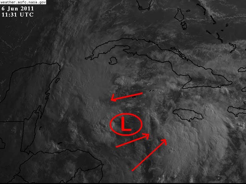
Re: ATL: INVEST 94L - DISCUSSION
NDG Said " Vis sat with the location of where I think the surface low center is located."
Which I think is spot on and may tighten up a bit father west under that Tower. Should see some pressure drops in a few hours.
Which I think is spot on and may tighten up a bit father west under that Tower. Should see some pressure drops in a few hours.
0 likes
The following post is NOT an official forecast and should not be used as such. It is just the opinion of the poster and may or may not be backed by sound meteorological data. It is NOT endorsed by any professional institution including storm2k.org For Official Information please refer to the NHC and NWS products.


-
wxman57

- Moderator-Pro Met

- Posts: 23172
- Age: 68
- Joined: Sat Jun 21, 2003 8:06 pm
- Location: Houston, TX (southwest)
Re: ATL: INVEST 94L - DISCUSSION
Weakening circulation, general lack of convergence, inconsistent and weak convection. Not indicators of development. I don't think it'll make it. Maybe some rain for Florida if they're lucky.

0 likes

Re: ATL: INVEST 94L - MODELS
I see Tampa has its deflector shield up on this run of the 06Z GFDL. 
http://moe.met.fsu.edu/cgi-bin/gfdltc2.cgi?time=2011060606-invest94l&field=Sea+Level+Pressure&hour=Animation
http://moe.met.fsu.edu/cgi-bin/gfdltc2.cgi?time=2011060606-invest94l&field=Sea+Level+Pressure&hour=Animation
0 likes
-
Dean4Storms
- S2K Supporter

- Posts: 6358
- Age: 63
- Joined: Sun Aug 31, 2003 1:01 pm
- Location: Miramar Bch. FL
-
lrak

- S2K Supporter
- Posts: 1770
- Age: 59
- Joined: Thu Jun 21, 2007 2:48 pm
- Location: Corpus Christi, TX
Re: ATL: INVEST 94L - DISCUSSION
I don't understand. Yesterday we were waiting for the convection to fire near the center now that it is you guys are having more doubts.
0 likes
AKA karl
Also
Personal Forecast Disclaimer:
My posts on this forum are NOT official forecast and should not be used as such. My posts are my basic observations and are definitely not backed by any "well some" meteorological knowledge. For official information, please refer to the NHC and NWS products.
Also
Personal Forecast Disclaimer:
My posts on this forum are NOT official forecast and should not be used as such. My posts are my basic observations and are definitely not backed by any "well some" meteorological knowledge. For official information, please refer to the NHC and NWS products.


-
wxman57
- Moderator-Pro Met
- Posts: 23172
- Age: 68
- Joined: Sat Jun 21, 2003 8:06 pm
- Location: Houston, TX (southwest)
Re: ATL: INVEST 94L - DISCUSSION
Look at the projected upper winds near western Cuba this week. SW-WSW winds 50-70 kts across western Cuba northward into the SE Gulf. Anything moving in that direction gets ripped apart. Only development chance is in the Caribbean, and it's moving out of the lighter winds now. I'm feeling more confident that we've already seen this system at its strongest.
0 likes
Re: ATL: INVEST 94L - DISCUSSION
The pre-Wilma disturbance was a horse of a different color - per wxman57, today's disturbance is in a weakening mode as most are at this time of year, and per the shear outlook, shear is forecast to become strong in the days ahead...
Frank
Frank
0 likes

Re: ATL: INVEST 94L - DISCUSSION
The local mets here only have our rain chances at 20% so this sytem will probably not affect us here in South Florida.
0 likes
Who is online
Users browsing this forum: No registered users and 16 guests