ATL: IRENE - Remnants - Discussion
Moderator: S2k Moderators
-
deltadog03

- Professional-Met

- Posts: 3580
- Joined: Tue Jul 05, 2005 6:16 pm
- Location: Macon, GA
-
RevDodd

- Tropical Storm

- Posts: 184
- Joined: Wed Aug 11, 2004 10:40 am
- Location: Fayetteville, NC
- Contact:
Question: I know about how stronger storms "create their own conditions" and how there was earlier concern that Irene's western outflow might help bolster the Atlantic ridge.
Does the same thought hold for a weaker, but larger, storm? Does the sheer bulk allow it to repair ridge erosion, continuing to steer north a bit longer?
Many thanks!
Does the same thought hold for a weaker, but larger, storm? Does the sheer bulk allow it to repair ridge erosion, continuing to steer north a bit longer?
Many thanks!
0 likes
-
ConvergenceZone
.gif)
- Category 5

- Posts: 5241
- Joined: Fri Jul 29, 2005 1:40 am
- Location: Northern California
Re: ATL: IRENE - Hurricane - Discussion
tolakram wrote:Longer IR loop: http://wwwghcc.msfc.nasa.gov/cgi-bin/ge ... =spect.pal
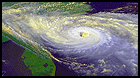
In my opinion the amount of apparent weakening seen in the IR loop is rather dramatic. I hope this does not lead to people downplay this storm.
I totally agree with you tolakram. I don't think I've ever seen a hurricane appear to be weakening this dramatically in this short period of time(I'm talking about satellite appearance ONLY) . As an example, Irene last night was totally loaded with oranges and deep reds around the center. The Reds are all but gone, and now the oranges are slowly thinning out as well..Pretty soon we might just be left with yellows. See this latest frame to see what I mean.
http://www.ssd.noaa.gov/goes/flt/t2/avn-l.jpg
Even if this only hits NC as a 75 mph to 85 mph storm (if this current weakening phase continues), it's going to still bring lots of tropical force winds and potentially of very heavy rains causing flooding up and down the coast.
Personal Forecast Disclaimer:
The posts in this forum are NOT official forecast and should not be used as such. They are just the opinion of the poster and may or may not be backed by sound meteorological data. They are NOT endorsed by any professional institution or storm2k.org. For official information, please refer to the NHC and NWS products.
Last edited by ConvergenceZone on Fri Aug 26, 2011 12:13 pm, edited 1 time in total.
0 likes

Re: ATL: IRENE - Hurricane - Discussion
Hopefully a little bit of good news...Dr. Masters commented on a collapse of the eye wall and cut off of south inflow due the shear...will take anything we can to try to limit this storm...or at least stop it from RI
0 likes

Re: ATL: IRENE - Recon
000
URNT15 KNHC 261709
AF306 2709A IRENE HDOB 49 20110826
165930 3118N 07711W 6962 02814 9642 +118 +052 138072 073 058 010 00
170000 3117N 07712W 6966 02799 9619 +129 +052 137073 074 060 009 00
170030 3116N 07714W 6967 02789 9606 +133 +052 140068 069 059 013 00
170100 3114N 07715W 6964 02780 9580 +145 +053 137069 070 057 016 00
170130 3113N 07716W 6975 02755 9576 +137 +053 131070 070 046 032 00
170200 3112N 07718W 6965 02754 9583 +115 +053 132069 070 058 032 00
170230 3111N 07719W 6961 02742 9561 +119 +054 141059 063 061 020 00
170300 3110N 07721W 6968 02721 9526 +143 +055 149048 051 061 011 00
170330 3108N 07722W 6968 02711 9508 +149 +055 158039 041 047 004 00
170400 3107N 07723W 6968 02708 9506 +147 +056 157030 035 039 002 03
170430 3106N 07725W 6967 02703 9494 +154 +059 145019 022 029 000 00
170500 3105N 07727W 6969 02699 9491 +152 +062 123012 014 026 001 03
170530 3104N 07728W 6966 02700 9494 +147 +064 100005 006 025 000 00
170600 3102N 07729W 6967 02699 9493 +150 +067 019003 004 022 001 00
170630 3100N 07730W 6967 02698 9489 +152 +070 325006 006 022 000 00
170700 3059N 07731W 6965 02703 9490 +153 +071 323010 012 025 000 00
170730 3057N 07732W 6973 02696 9490 +154 +073 327015 017 /// /// 03
170800 3058N 07734W 6961 02714 9477 +172 +075 329021 023 022 000 03
170830 3058N 07736W 6968 02709 9482 +171 +076 338025 030 027 001 03
170900 3058N 07738W 6967 02716 9489 +171 +077 336035 038 035 000 00
$$
;
0 likes

Re: ATL: IRENE - Hurricane - Discussion
MyrtleBeachGal1967 wrote:Here is a live webcam set up at Pier 14 in Myrtle Beach
http://www.youtube.com/user/WPDENewsChannel15#p/l/CDYOcZ5t3N4
That webcam is shaking like it won't be around much longer... :/
0 likes
-
Dave

- Retired Staff

- Posts: 13442
- Age: 75
- Joined: Tue Aug 01, 2006 3:57 pm
- Location: Milan Indiana
- Contact:
Next mission today....may need some help on this one, I for one must report to my local office for a few hours today which will take me out. We need for someone for hdobs especially & anyone who can do graphics with them or both is a huge plus. Thanks for your help!
FLIGHT THREE -- TEAL 71
A. 26/21Z,27/00Z,03Z
B. AFXXX 2909A IRENE
C. 26/18Z
D. 31.0N 77.6W
E. 26/2030Z TO 27/03Z
F. SFC TO 15,000 FT
FLIGHT THREE -- TEAL 71
A. 26/21Z,27/00Z,03Z
B. AFXXX 2909A IRENE
C. 26/18Z
D. 31.0N 77.6W
E. 26/2030Z TO 27/03Z
F. SFC TO 15,000 FT
0 likes
This post is NOT AN OFFICIAL FORECAST and should not be used as such. It is just the opinion of the poster and may or may not be backed by sound meteorological data. It is NOT endorsed by any professional institution including storm2k.org. For Official Information please refer to the NHC and NWS products.

Re: ATL: IRENE - Hurricane - Discussion
could it be the storm is so big that the early interaction with land is causing the apparent weakening?
0 likes
Just like Jon Snow..."I know nothing" except what I know, and most of what I know is gathered by the fine people of the NHC

ATL: IRENE - Models
Never mind... seems like it probably is hundreths, but is that a cumulative, or 3 hourly mean?
0 likes
-
ConvergenceZone
- Category 5
- Posts: 5241
- Joined: Fri Jul 29, 2005 1:40 am
- Location: Northern California
Re: ATL: IRENE - Hurricane - Discussion
TPAcane wrote:Hopefully a little bit of good news...Dr. Masters commented on a collapse of the eye wall and cut off of south inflow due the shear...will take anything we can to try to limit this storm...or at least stop it from RI
Don't worry RI is NOT an issue with Irene, but that comment fro Dr Masters was posted quite earlier today.
0 likes
-
Dave
- Retired Staff
- Posts: 13442
- Age: 75
- Joined: Tue Aug 01, 2006 3:57 pm
- Location: Milan Indiana
- Contact:

0 likes
This post is NOT AN OFFICIAL FORECAST and should not be used as such. It is just the opinion of the poster and may or may not be backed by sound meteorological data. It is NOT endorsed by any professional institution including storm2k.org. For Official Information please refer to the NHC and NWS products.

Re: ATL: IRENE - Models
InstantWeatherMaps wrote:Then look at this:
[img]http://img4.imageshack.us/img4/9973/f87.gif[ /img]
There's no way that many members would be showing 30" of rain.
That would be hundreths of an inch. 800 = 8 inches.
0 likes
-
SNOW_JOKE
- Tropical Depression

- Posts: 98
- Age: 42
- Joined: Mon Aug 01, 2011 7:47 pm
- Location: United Kingdom
Re: ATL: IRENE - Hurricane - Discussion
0 likes
For Official Information please refer to the NHC and NWS Websites.
-
InstantWeatherMaps

- Tropical Low

- Posts: 44
- Joined: Sat Aug 20, 2011 9:47 pm
Re: ATL: IRENE - Models
RL3AO wrote:InstantWeatherMaps wrote:Then look at this:
[img]http://img4.imageshack.us/img4/9973/f87.gif[ /img]
There's no way that many members would be showing 30" of rain.
That would be hundreths of an inch. 800 = 8 inches.
Exactly what I was saying.
poof121 wrote:Never mind... seems like it probably is hundreths, but is that a cumulative, or 3 hourly mean?
The one you were asking about (with 150 or so as the top number) are for the 3 hours before the forecast hour. The one I posted was a total for all 87 hours of the run.
0 likes

Re: ATL: IRENE - Models
Combined CMC, GFS, ECMWF, UKMET ensemble (117 members) initialized 8/26/11 at 00Z. You can interpret this as the probability of Irene passing within 150 km of any given point. As an example, there is a 80% probability of Irene passing less than 150 km from NYC. Also gives an alternative view of the cone of uncertainty, and there's not very much uncertainty at this point in time.

--
http://wind.mit.edu/~btangy/Home/TCGuid.htm
--
http://wind.mit.edu/~btangy/Home/TCGuid.htm
Last edited by btangy on Fri Aug 26, 2011 12:23 pm, edited 1 time in total.
0 likes
Re: ATL: IRENE - Models
InstantWeatherMaps wrote:Exactly what I was saying.
Oops. Too many quotes.
0 likes
Re: ATL: IRENE - Recon
000
URNT15 KNHC 261719
AF306 2709A IRENE HDOB 50 20110826
170930 3058N 07739W 6970 02725 9480 +191 +077 337047 049 045 000 00
171000 3058N 07741W 6968 02737 9484 +199 +078 342052 053 049 000 03
171030 3058N 07743W 6967 02750 9499 +195 +078 342057 057 051 000 03
171100 3058N 07745W 6963 02765 9519 +185 +078 346058 058 051 000 00
171130 3058N 07747W 6969 02772 9545 +175 +078 347061 063 049 000 03
171200 3058N 07749W 6967 02784 9559 +171 +077 348064 065 050 000 03
171230 3058N 07751W 6966 02795 9573 +168 +075 350065 066 050 000 03
171300 3058N 07753W 6969 02804 9591 +163 +074 351064 064 049 000 03
171330 3058N 07755W 6970 02814 9607 +157 +074 350063 064 048 002 00
171400 3058N 07757W 6963 02831 9623 +153 +073 349062 063 048 000 00
171430 3058N 07758W 6969 02829 9636 +148 +073 348065 065 049 000 00
171500 3058N 07800W 6967 02843 9651 +143 +071 348064 065 049 000 03
171530 3058N 07802W 6966 02856 9658 +148 +071 350062 062 049 000 03
171600 3058N 07804W 6969 02856 9663 +148 +071 350060 061 050 000 03
171630 3058N 07806W 6966 02866 9669 +147 +070 351060 060 051 000 00
171700 3058N 07808W 6971 02865 9678 +146 +070 350060 061 055 002 00
171730 3058N 07810W 6967 02877 9683 +147 +070 349064 066 058 001 00
171800 3057N 07812W 6963 02888 9697 +140 +070 347066 067 060 001 00
171830 3057N 07814W 6973 02879 9697 +146 +069 346067 068 062 000 00
171900 3057N 07816W 6966 02894 9707 +141 +068 346073 074 063 002 00
$$
0 likes
-
mf_dolphin

- Category 5
- Posts: 17758
- Age: 69
- Joined: Tue Oct 08, 2002 2:05 pm
- Location: St Petersburg, FL
- Contact:
Re: ATL: IRENE - Hurricane - Discussion
janswizard wrote:Off topic and I apologize in advance. Does anyone know why the live link isn't working?
If you're talking about the HurricaneTrack live feed, they are having some issues but expect to have it back on-line soon.
0 likes
-
Dave
- Retired Staff
- Posts: 13442
- Age: 75
- Joined: Tue Aug 01, 2006 3:57 pm
- Location: Milan Indiana
- Contact:

0 likes
This post is NOT AN OFFICIAL FORECAST and should not be used as such. It is just the opinion of the poster and may or may not be backed by sound meteorological data. It is NOT endorsed by any professional institution including storm2k.org. For Official Information please refer to the NHC and NWS products.
little bit of convection coming back...as a point of reference, there was a solid white ring three times that size last night
http://aviationweather.gov/adds/satelli ... g&itype=ir
http://aviationweather.gov/adds/satelli ... g&itype=ir
0 likes
Just like Jon Snow..."I know nothing" except what I know, and most of what I know is gathered by the fine people of the NHC
Who is online
Users browsing this forum: No registered users and 24 guests