ATL : HARVEY - Tropical Depression - Discussion
Moderator: S2k Moderators
-
SouthFloridawx

- S2K Supporter

- Posts: 8346
- Age: 47
- Joined: Tue Jul 26, 2005 1:16 am
- Location: Sarasota, FL
- Contact:
-
CYCLONE MIKE
- Category 5

- Posts: 2183
- Joined: Tue Aug 31, 2004 6:04 pm
- Location: Gonzales, LA
Re: ATL : INVEST 93L - Discussion
And POOF it goes. Maybe in the next couple of days something might happen. Not until its near the Yucatan.
0 likes
-
expat2carib

- S2K Supporter
- Posts: 458
- Joined: Tue Jul 22, 2008 1:44 pm
- Location: Sint Maarten

-
Aric Dunn
- Category 5
- Posts: 21238
- Age: 43
- Joined: Sun Sep 19, 2004 9:58 pm
- Location: Ready for the Chase.
- Contact:
yeah like and a few others mentioned before... its moving way way too fast ... look for any possible development in 3 to 4 days in the western/ nw carrib... if any at all
0 likes
Note: If I make a post that is brief. Please refer back to previous posts for the analysis or reasoning. I do not re-write/qoute what my initial post said each time.
If there is nothing before... then just ask
Space & Atmospheric Physicist, Embry-Riddle Aeronautical University,
I believe the sky is falling...
If there is nothing before... then just ask
Space & Atmospheric Physicist, Embry-Riddle Aeronautical University,
I believe the sky is falling...
-
Rgv20

- S2K Supporter
- Posts: 2466
- Age: 39
- Joined: Wed Jan 05, 2011 5:42 pm
- Location: Edinburg/McAllen Tx
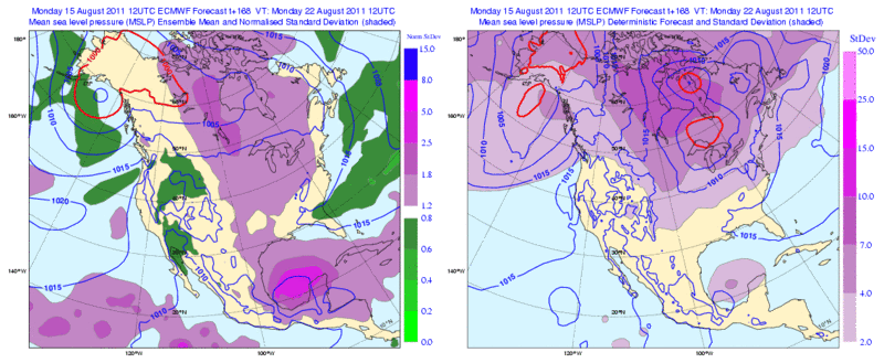
Interesting to note that some 12zECMWF Ensembles members are a tad further north and slower with 93L by day 7 represented by the light purple color on the right panel west of the Yucatan.
0 likes
The following post is NOT an official forecast and should not be used as such. It is just the opinion of the poster and may or may not be backed by sound meteorological data. It is NOT endorsed by any professional institution including storm2k.org For Official Information please refer to the NHC and NWS products.
-
HurricaneWarning92
- Category 2

- Posts: 520
- Joined: Sat Jul 23, 2011 4:33 pm
- Location: Pembroke Pines, S. Florida (Lat: 26.00N, Lon: 80.22W)
I gave up with this one on development. I dont think it will develop into more than a moderate TC, if at all. I wouldnt be surprised if it doesnt develop at all. Of course this is just my opinion.
0 likes
The posts in this forum are NOT official forecast and should not be used as such. They are just the opinion of the poster and may or may not be backed by sound meteorological data. They are NOT endorsed by any professional institution or storm2k.org. For official information, please refer to the NHC and NWS products.
-
wxman57

- Moderator-Pro Met

- Posts: 23173
- Age: 68
- Joined: Sat Jun 21, 2003 8:06 pm
- Location: Houston, TX (southwest)
Re: ATL : INVEST 93L - Discussion
This was to be expected. Lots of dry air in the eastern Caribbean. I still give it about a 50% shot at becoming a TS on Friday. Less than 10% the next 2-3 days, though.
0 likes
-
Rgv20
- S2K Supporter
- Posts: 2466
- Age: 39
- Joined: Wed Jan 05, 2011 5:42 pm
- Location: Edinburg/McAllen Tx
Looking at the forecast steering charts, 93L should start to slow down some when it approaches 80W and it should have about 36 to 48 hours of very favorable conditions before it arrives to the Yucatan.
0 likes
The following post is NOT an official forecast and should not be used as such. It is just the opinion of the poster and may or may not be backed by sound meteorological data. It is NOT endorsed by any professional institution including storm2k.org For Official Information please refer to the NHC and NWS products.
-
dolebot_Broward_NW
- Category 2
- Posts: 529
- Joined: Fri Sep 10, 2004 6:38 am
Re: ATL : INVEST 93L - Discussion
Annnnnnd the Graveyard strikes again. I'm not ringing the death bell yet, nor am I calling Bones in though. Got a little ways to go yet.
0 likes
-
Florida1118
Re: ATL : INVEST 93L - Discussion
dolebot_Broward_NW wrote:Annnnnnd the Graveyard strikes again. I'm not ringing the death bell yet, nor am I calling Bones in though. Got a little ways to go yet.
It cannot sustain itself yet, so convection is going to diminish. Wait until DMAX
0 likes
-
cycloneye

- Admin

- Posts: 149381
- Age: 69
- Joined: Thu Oct 10, 2002 10:54 am
- Location: San Juan, Puerto Rico
Re: ATL : INVEST 93L - Discussion
Latest ASCAT pass made around 10:00 PM EDT shows no surface circulation.

0 likes
Visit the Caribbean-Central America Weather Thread where you can find at first post web cams,radars
and observations from Caribbean basin members Click Here
and observations from Caribbean basin members Click Here


-
South Texas Storms

- Professional-Met

- Posts: 4257
- Joined: Thu Jun 24, 2010 12:28 am
- Location: Houston, TX
Re: ATL: INVEST 93L - Models
0 likes

Re: ATL : INVEST 93L - Discussion
wxman57 wrote:This was to be expected. Lots of dry air in the eastern Caribbean. I still give it about a 50% shot at becoming a TS on Friday. Less than 10% the next 2-3 days, though.
Wxman, Do storms that roll through these dry areas actually eliminate or lessen the dry air? Sounds like an elementary answer but to be honest I wasn't sure. Does the dry air act as a sponge?
0 likes

-
cycloneye
- Admin
- Posts: 149381
- Age: 69
- Joined: Thu Oct 10, 2002 10:54 am
- Location: San Juan, Puerto Rico
Re:
Adoquín wrote:I do not think it has to with SAL. Latest graphics show SAL is actually on the wane in front of it. As to dry air, it was much worse 2 days before. So granted the Eastern Caribbean is not great climatologically, but that cannot be the main culprit.
Is moving way too fast and that may be one of the main factors.Let's see when the slowdown occurs if it takes advantage of the very warm waters in the Western Caribbean.
0 likes
Visit the Caribbean-Central America Weather Thread where you can find at first post web cams,radars
and observations from Caribbean basin members Click Here
and observations from Caribbean basin members Click Here

Re: ATL : INVEST 93L - Discussion
Come on guys yall know it's gonna flare up again in the morning and probably die off again 24 hrs. from now.
0 likes
The following post is NOT an official forecast and should not be used as such. It is just the opinion of the poster and may or may not be backed by sound meteorological data. It is NOT endorsed by any professional institution including storm2k.org For Official Information please refer to the NHC and NWS products.

Re: ATL: INVEST 93L - Models
12Z NOGAPS does the CA thing again....given the poof tonight becoming more plausible....
0 likes
Who is online
Users browsing this forum: No registered users and 8 guests