ATL: KATIA - Post Tropical - Discussion
Moderator: S2k Moderators
-
meriland23

- Category 5

- Posts: 1239
- Age: 38
- Joined: Mon Aug 29, 2011 9:29 pm
I got the feeling this thing is going to be a lot faster in foreward speed than anticipated. I wonder how that will effect models.
0 likes
The posts in this forum are NOT official forecast and should not be used as such. They are just the opinion of the poster and may or may not be backed by sound meteorological data. They are NOT endorsed by any professional institution or storm2k.org. For official information, please refer to the NHC and NWS products.

Re: ATL: KATIA - Tropical Storm - Discussion
theweatherwatch wrote:The next NHC update is at 5am
Unless of course the eye clears out and something crazy happens, in which case it would be sooner.
0 likes
-
Trishasmom
- Tropical Low

- Posts: 23
- Joined: Sun Aug 17, 2008 4:31 pm
- Location: Charles City, VA
Re: Re:
gatorcane wrote:meriland23 wrote::?: People really need to stop and take a look at how far away we are from the potential of ANY landfall what-so-ever and try and remember the last time any forecasted track was correct 10 days in advance. Anyone? No? That is what I thought. The track this far ahead in time has at least proven to me to be shoddy at best. Irene was supposed to be a FL hurricane or a extremely curved one that never even set sights on the US, look what happened with that! Hurricanes do what they do and have a mind of their own. If it does not want to follow your track, it aint gonna. Seems when a Hurricane does the opposite of expectations, there is some hidden reason forecasters overlooked or did not take into consideration. I am confident that this will not take the PP estimated this early on, cause it was estimated this early on lol.Hello, while nobody can say for certain where she ends up and whether she impacts the United States, there is reasonable certainty at this time it will not be a United States impact (see models thread for discussion).The posts in this forum are NOT official forecast and should not be used as such. They are just the opinion of the poster and may or may not be backed by sound meteorological data. They are NOT endorsed by any professional institution or storm2k.org. For official information, please refer to the NHC and NWS products.
After what we just went through, let me say I would much rather be prepared for the worst and not get it than think oh this is nothing and get the worst. We even prepared to the best we could for Irene but our best wasn't enough. Thank God and all those wonderful power crews who got our power back on this evening. You can bet I'm watching Katia like a hawk. I dont care how far away it is.... it's no far enough away as far as I am concerned. I'm tired and worn out from Irene not in the mood to deal with Katia but am already starting to get ready just in case. Lost all of our food in fridge and freezer but gonna just replace can goods until I see what Katia has planned and then will rethink my shopping.
I do want to give a big thumbs up for all those men and women who are working so hard to restore power to everyone. It is much appreciated. We were without power for 2 weeks with Isabel and only 4 days with Irene so much faster even though in our area we had more damage this time in my opinion. Power lines down up and down the road in our area. Scary!!!!
Carol
0 likes
-
cycloneye

- Admin

- Posts: 149379
- Age: 69
- Joined: Thu Oct 10, 2002 10:54 am
- Location: San Juan, Puerto Rico
Re: ATL: KATIA - Tropical Storm - Discussion
This ASCAT pass was made around 8 PM EDT.

Saved image.
Saved image.
0 likes
Visit the Caribbean-Central America Weather Thread where you can find at first post web cams,radars
and observations from Caribbean basin members Click Here
and observations from Caribbean basin members Click Here
Re: ATL: KATIA - Tropical Storm - Discussion
The scatterometer image backs up the 00Z best track placement; the estimates of the Dvorak analysts were a too far east. As the discussion stated, center was more to the edge of convection rather than the center of it.
Latest shortwave infrared image:

Latest shortwave infrared image:

0 likes
-
meriland23
- Category 5
- Posts: 1239
- Age: 38
- Joined: Mon Aug 29, 2011 9:29 pm
Re: ATL: KATIA - Tropical Storm - Discussion
clfenwi wrote:The scatterometer image backs up the 00Z best track placement; the estimates of the Dvorak analysts were a too far east. As the discussion stated, center was more to the edge of convection rather than the center of it.
Latest shortwave infrared image:
http://imageshack.us/photo/my-images/70 ... tiair2.jpg[/url]
My goodness, look at that eye!
Btw, just fill me in, I am still learning. What is the scatterometer? And also , being the center is more to the edge of convection than the center like you stated, does that indicate something in reference to the track placement?
0 likes
The posts in this forum are NOT official forecast and should not be used as such. They are just the opinion of the poster and may or may not be backed by sound meteorological data. They are NOT endorsed by any professional institution or storm2k.org. For official information, please refer to the NHC and NWS products.

Re: ATL: KATIA - Tropical Storm - Discussion
I'm thinking thats not an eye. Just an illusion. Look how weak the convection is on the NW side.
However the area at 13.5 37 maybe does look like an eyewall at 2nd look.
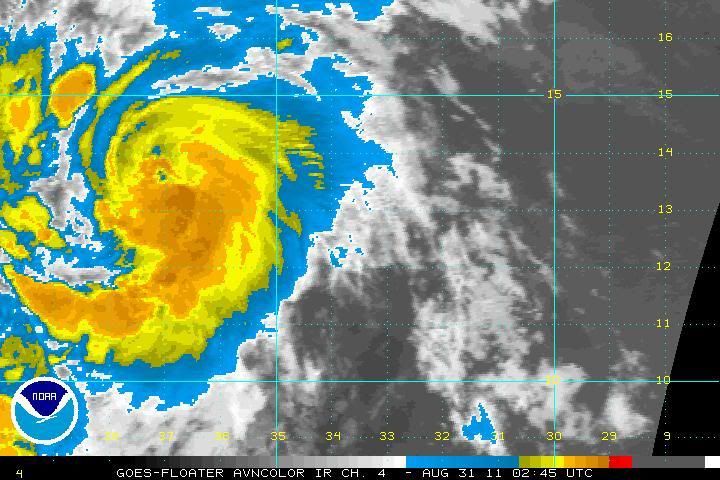
However the area at 13.5 37 maybe does look like an eyewall at 2nd look.
0 likes
-
SouthFloridawx

- S2K Supporter

- Posts: 8346
- Age: 47
- Joined: Tue Jul 26, 2005 1:16 am
- Location: Sarasota, FL
- Contact:
-
Aric Dunn
- Category 5
- Posts: 21238
- Age: 43
- Joined: Sun Sep 19, 2004 9:58 pm
- Location: Ready for the Chase.
- Contact:
Re: ATL: KATIA - Tropical Storm - Discussion
RL3AO wrote:I'm thinking thats not an eye. Just an illusion. Look how weak the convection is on the NW side.
However the area at 13.5 37 maybe does look like an eyewall at 2nd look.
[img]http://i44.photobucket.com/albums/f38/RL3AO/avn-l-3.jpg[/ig]
oh it is the beginnings of one. you can tell be that last burst of convection and the motion it took around the feature. still in its development stages of course so it going to look worse at times and fill in and look ragged. till deep convection maintains around it..
0 likes
Note: If I make a post that is brief. Please refer back to previous posts for the analysis or reasoning. I do not re-write/qoute what my initial post said each time.
If there is nothing before... then just ask
Space & Atmospheric Physicist, Embry-Riddle Aeronautical University,
I believe the sky is falling...
If there is nothing before... then just ask
Space & Atmospheric Physicist, Embry-Riddle Aeronautical University,
I believe the sky is falling...
-
cycloneye
- Admin
- Posts: 149379
- Age: 69
- Joined: Thu Oct 10, 2002 10:54 am
- Location: San Juan, Puerto Rico
Re: ATL: KATIA - Tropical Storm - Discussion
Aric,a dry slot or an eyefeature?

Saved image.
Saved image.
0 likes
Visit the Caribbean-Central America Weather Thread where you can find at first post web cams,radars
and observations from Caribbean basin members Click Here
and observations from Caribbean basin members Click Here
-
SouthFloridawx
- S2K Supporter
- Posts: 8346
- Age: 47
- Joined: Tue Jul 26, 2005 1:16 am
- Location: Sarasota, FL
- Contact:
Re: ATL: KATIA - Models
NCAR's new Website is pretty cool. It even has an archive of model runs.
http://www.ral.ucar.edu/hurricanes/realtime/current/

http://www.ral.ucar.edu/hurricanes/realtime/current/
0 likes
-
SouthFloridawx
- S2K Supporter
- Posts: 8346
- Age: 47
- Joined: Tue Jul 26, 2005 1:16 am
- Location: Sarasota, FL
- Contact:

Re: ATL: KATIA - Tropical Storm - Discussion
meriland23 wrote:My goodness, look at that eye!
Btw, just fill me in, I am still learning. What is the scatterometer? And also , being the center is more to the edge of convection than the center like you stated, does that indicate something in reference to the track placement?
Wind scatterometers are instruments on satellites that measure (near) surface winds over water. The image Cycloneye posted was from the Advanced Scatterometer (ASCAT) carried onboard a European satellite.
Noticing that the center is more to the edge of convection was important to establishing the initial position of the storm, which in turn establishes the estimated storm motion. Had the center been placed further east, the estimated motion would have been slower, which would have affected the forecast.
0 likes
-
Aric Dunn
- Category 5
- Posts: 21238
- Age: 43
- Joined: Sun Sep 19, 2004 9:58 pm
- Location: Ready for the Chase.
- Contact:
Re: ATL: KATIA - Tropical Storm - Discussion
cycloneye wrote:Aric,a dry slot or an eyefeature?
[img]http://img231.imageshack.us/img231/7566/wvlu.jpg[/ig]
Saved image.
its easier to follow in this loops. http://www.ssd.noaa.gov/goes/flt/t2/loop-rgb.html
you can see as the convection waned the mid and low level center than more convection developed on south side covering it and rotating around to the east where it is now weakening again.. the little hole that is wobbling around is just the burst of convection partially covering the earlier visible mid and low level circ.. its the beginning of it but not a true eye as the eyewall is not quite established yet.
0 likes
Note: If I make a post that is brief. Please refer back to previous posts for the analysis or reasoning. I do not re-write/qoute what my initial post said each time.
If there is nothing before... then just ask
Space & Atmospheric Physicist, Embry-Riddle Aeronautical University,
I believe the sky is falling...
If there is nothing before... then just ask
Space & Atmospheric Physicist, Embry-Riddle Aeronautical University,
I believe the sky is falling...
-
SouthFloridawx
- S2K Supporter
- Posts: 8346
- Age: 47
- Joined: Tue Jul 26, 2005 1:16 am
- Location: Sarasota, FL
- Contact:
-
meriland23
- Category 5
- Posts: 1239
- Age: 38
- Joined: Mon Aug 29, 2011 9:29 pm
Re: ATL: KATIA - Models
SouthFloridawx wrote:NCAR's new Website is pretty cool. It even has an archive of model runs.
http://www.ral.ucar.edu/hurricanes/realtime/current/
http://img535.imageshack.us/img535/1107 ... ackear.png
What the ... BAMS track would surely confuse me, I would be convinced Katia drinkin' too much and getting a little tipsy.

0 likes
The posts in this forum are NOT official forecast and should not be used as such. They are just the opinion of the poster and may or may not be backed by sound meteorological data. They are NOT endorsed by any professional institution or storm2k.org. For official information, please refer to the NHC and NWS products.
-
AnnularCane

- S2K Supporter
- Posts: 2961
- Joined: Thu Jun 08, 2006 9:18 am
- Location: Wytheville, VA
Re: ATL: KATIA - Tropical Storm - Discussion
She looks like a little embryo on the shortwave infrared image.
0 likes
-
Annie Oakley

- Category 5
- Posts: 1103
- Joined: Tue Jul 31, 2007 12:54 pm
- Location: Texas
-
meriland23
- Category 5
- Posts: 1239
- Age: 38
- Joined: Mon Aug 29, 2011 9:29 pm
Re: ATL: KATIA - Tropical Storm - Discussion
She is seriously bookin it, she wants to get somewhere fast. 
0 likes
The posts in this forum are NOT official forecast and should not be used as such. They are just the opinion of the poster and may or may not be backed by sound meteorological data. They are NOT endorsed by any professional institution or storm2k.org. For official information, please refer to the NHC and NWS products.
-
dolebot_Broward_NW
- Category 2

- Posts: 529
- Joined: Fri Sep 10, 2004 6:38 am
Re: ATL: KATIA - Models
sandyb wrote:Our local met said we need to watch there the "hurricane" is and if it hits Japan it Japan gets hit then we have a good chance of getting hit by Katia if it misses Japan then Katia will most likely stay away from the US East Coast, I live in North Carolina we just got Irene and I don't want another hurricane this year we have had our fix for at least 5 years if that is what you can call it. some of still dont have power and looking at several more days here.
What in Seven Hells? What is this madness?! How can one cane influence another?
0 likes
Who is online
Users browsing this forum: No registered users and 24 guests