WPAC: CO-MAY - Tropical Depression - Discussion
Moderators: S2k Moderators, WesternPacificWeatherMods
Forum rules

The posts in this forum are NOT official forecast and should not be used as such. They are just the opinion of the poster and may or may not be backed by sound meteorological data. They are NOT endorsed by any professional institution or STORM2K.
-
ElectricStorm

- Category 5

- Posts: 5049
- Age: 24
- Joined: Tue Aug 13, 2019 11:23 pm
- Location: Skiatook, OK / Norman, OK
Re: WPAC: CO-MAY (EMONG PH) - Tropical Storm - Discussion
Looks well on its way to becoming a typhoon, 40 kts it's likely too low. Doesn't have much time but should easily make it to at least Cat 1 at this rate.
0 likes
B.S Meteorology, University of Oklahoma '25
Please refer to the NHC, NWS, or SPC for official information.
Please refer to the NHC, NWS, or SPC for official information.
-
cycloneye

- Admin

- Posts: 145455
- Age: 68
- Joined: Thu Oct 10, 2002 10:54 am
- Location: San Juan, Puerto Rico
Re: WPAC: CO-MAY (EMONG PH) - Tropical Storm - Discussion
Up to 60kt.
11W CO-MAY 250723 1800 16.9N 118.0E WPAC 60 981
0 likes
Visit the Caribbean-Central America Weather Thread where you can find at first post web cams,radars
and observations from Caribbean basin members Click Here
and observations from Caribbean basin members Click Here
-
Hurricane2022

- Category 5
- Posts: 1556
- Joined: Tue Aug 23, 2022 11:38 pm
- Location: Araçatuba, Brazil
Re: WPAC: CO-MAY (EMONG PH) - Tropical Storm - Discussion
cycloneye wrote:Up to 60kt.11W CO-MAY 250723 1800 16.9N 118.0E WPAC 60 981
JMA still dead at 35 kt. Filipinos are lucky to have PAGASA as their official source of weather information. JMA sometimes looks suicidal with these estimates
1 likes
Sorry for the bad English sometimes...!
For reliable and detailed information for any meteorological phenomenon, please consult the National Hurricane Center, Joint Typhoon Warning Center , or your local Meteo Center.
--------
Una cvm Christo, pro Christo, et in Christo. Sit nomen Domini benedictvm.
For reliable and detailed information for any meteorological phenomenon, please consult the National Hurricane Center, Joint Typhoon Warning Center , or your local Meteo Center.
--------
Una cvm Christo, pro Christo, et in Christo. Sit nomen Domini benedictvm.
-
cycloneye
- Admin
- Posts: 145455
- Age: 68
- Joined: Thu Oct 10, 2002 10:54 am
- Location: San Juan, Puerto Rico
Re: WPAC: CO-MAY (EMONG PH) - Tropical Storm - Discussion
Yikes. Landfall at 85kts.

0 likes
Visit the Caribbean-Central America Weather Thread where you can find at first post web cams,radars
and observations from Caribbean basin members Click Here
and observations from Caribbean basin members Click Here
-
mrbagyo

- Category 5
- Posts: 3731
- Age: 33
- Joined: Thu Apr 12, 2012 9:18 am
- Location: 14.13N 120.98E
- Contact:
Re: WPAC: CO-MAY (EMONG PH) - Tropical Storm - Discussion
2 likes
The posts in this forum are NOT official forecast and should not be used as such. They are just the opinion of the poster and may or may not be backed by sound meteorological data. They are NOT endorsed by any professional institution or storm2k.org. For official information, please refer to RSMC, NHC and NWS products.
-
cycloneye
- Admin
- Posts: 145455
- Age: 68
- Joined: Thu Oct 10, 2002 10:54 am
- Location: San Juan, Puerto Rico
Re: WPAC: CO-MAY (EMONG PH) - Tropical Storm - Discussion
Up to Typhoon.
11W CO-MAY 250724 0000 16.2N 118.6E WPAC 70 975
1 likes
Visit the Caribbean-Central America Weather Thread where you can find at first post web cams,radars
and observations from Caribbean basin members Click Here
and observations from Caribbean basin members Click Here
-
Hurricane2022
- Category 5
- Posts: 1556
- Joined: Tue Aug 23, 2022 11:38 pm
- Location: Araçatuba, Brazil
Re: WPAC: CO-MAY (EMONG PH) - Tropical Storm - Discussion
cycloneye wrote:Up to Typhoon.11W CO-MAY 250724 0000 16.2N 118.6E WPAC 70 975
JMA only at 40 kt right now!!!

0 likes
Sorry for the bad English sometimes...!
For reliable and detailed information for any meteorological phenomenon, please consult the National Hurricane Center, Joint Typhoon Warning Center , or your local Meteo Center.
--------
Una cvm Christo, pro Christo, et in Christo. Sit nomen Domini benedictvm.
For reliable and detailed information for any meteorological phenomenon, please consult the National Hurricane Center, Joint Typhoon Warning Center , or your local Meteo Center.
--------
Una cvm Christo, pro Christo, et in Christo. Sit nomen Domini benedictvm.
-
cycloneye
- Admin
- Posts: 145455
- Age: 68
- Joined: Thu Oct 10, 2002 10:54 am
- Location: San Juan, Puerto Rico
Re: WPAC: CO-MAY (EMONG PH) - Tropical Storm - Discussion
JMA to 50kts.
T2508(Co-may)
Issued at 2025/07/24 01:10 UTC
Analysis at 07/24 00 UTC
Grade STS
Scale -
Intensity -
Center position N16°30′ (16.5°)
E117°55′ (117.9°)
Direction and speed of movement SSE 15 km/h (7 kt)
Central pressure 985 hPa
Maximum sustained wind speed near center 25 m/s (50 kt)
Maximum wind gust speed 35 m/s (70 kt)
Radius of 30-kt wind area SW330 km (180 NM)
NE220 km (120 NM)
0 likes
Visit the Caribbean-Central America Weather Thread where you can find at first post web cams,radars
and observations from Caribbean basin members Click Here
and observations from Caribbean basin members Click Here
-
cycloneye
- Admin
- Posts: 145455
- Age: 68
- Joined: Thu Oct 10, 2002 10:54 am
- Location: San Juan, Puerto Rico
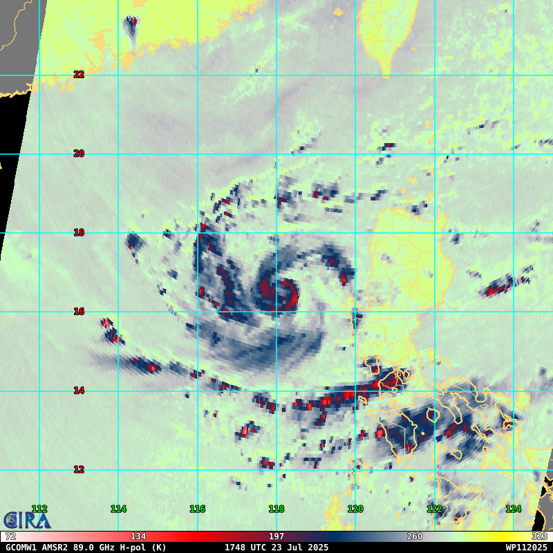
Re: WPAC: CO-MAY (EMONG PH) - Severe Tropical Storm - Discussion
0 likes
Visit the Caribbean-Central America Weather Thread where you can find at first post web cams,radars
and observations from Caribbean basin members Click Here
and observations from Caribbean basin members Click Here
-
cycloneye
- Admin
- Posts: 145455
- Age: 68
- Joined: Thu Oct 10, 2002 10:54 am
- Location: San Juan, Puerto Rico
Re: WPAC: CO-MAY (EMONG PH) - Severe Tropical Storm - Discussion

0 likes
Visit the Caribbean-Central America Weather Thread where you can find at first post web cams,radars
and observations from Caribbean basin members Click Here
and observations from Caribbean basin members Click Here
-
dexterlabio
- Category 5
- Posts: 3470
- Joined: Sat Oct 24, 2009 11:50 pm
Re: WPAC: CO-MAY (EMONG PH) - Severe Tropical Storm - Discussion
If we were in a classic El Niño year, these three simultaneous TCs in the WPAC right now would have easily become Cat3 + typhoons.
0 likes

Re: WPAC: CO-MAY (EMONG PH) - Severe Tropical Storm - Discussion
Landfall shifted again (to south)

0 likes
ヤンデレ女が寝取られるているのを見たい!!!
ECMWF ensemble NWPAC plots: https://ecmwfensnwpac.imgbb.com/
Multimodel NWPAC plots: https://multimodelnwpac.imgbb.com/
GFS Ensemble NWPAC plots (16 & 35 day forecast): https://gefsnwpac.imgbb.com/
Plots updated automatically
ECMWF ensemble NWPAC plots: https://ecmwfensnwpac.imgbb.com/
Multimodel NWPAC plots: https://multimodelnwpac.imgbb.com/
GFS Ensemble NWPAC plots (16 & 35 day forecast): https://gefsnwpac.imgbb.com/
Plots updated automatically
Re: WPAC: CO-MAY (EMONG PH) - Severe Tropical Storm - Discussion
Down to 60 kts
11W CO-MAY 250724 1200 16.2N 119.6E WPAC 60 974
1 likes
ヤンデレ女が寝取られるているのを見たい!!!
ECMWF ensemble NWPAC plots: https://ecmwfensnwpac.imgbb.com/
Multimodel NWPAC plots: https://multimodelnwpac.imgbb.com/
GFS Ensemble NWPAC plots (16 & 35 day forecast): https://gefsnwpac.imgbb.com/
Plots updated automatically
ECMWF ensemble NWPAC plots: https://ecmwfensnwpac.imgbb.com/
Multimodel NWPAC plots: https://multimodelnwpac.imgbb.com/
GFS Ensemble NWPAC plots (16 & 35 day forecast): https://gefsnwpac.imgbb.com/
Plots updated automatically
Re: WPAC: CO-MAY (EMONG PH) - Severe Tropical Storm - Discussion
Hayabusa wrote:Down to 60 kts11W CO-MAY 250724 1200 16.2N 119.6E WPAC 60 974
Revised to 65
11W CO-MAY 250724 1200 16.1N 119.5E WPAC 65 976

0 likes
ヤンデレ女が寝取られるているのを見たい!!!
ECMWF ensemble NWPAC plots: https://ecmwfensnwpac.imgbb.com/
Multimodel NWPAC plots: https://multimodelnwpac.imgbb.com/
GFS Ensemble NWPAC plots (16 & 35 day forecast): https://gefsnwpac.imgbb.com/
Plots updated automatically
ECMWF ensemble NWPAC plots: https://ecmwfensnwpac.imgbb.com/
Multimodel NWPAC plots: https://multimodelnwpac.imgbb.com/
GFS Ensemble NWPAC plots (16 & 35 day forecast): https://gefsnwpac.imgbb.com/
Plots updated automatically
-
cycloneye
- Admin
- Posts: 145455
- Age: 68
- Joined: Thu Oct 10, 2002 10:54 am
- Location: San Juan, Puerto Rico
Re: WPAC: CO-MAY (EMONG PH) - Severe Tropical Storm - Discussion

0 likes
Visit the Caribbean-Central America Weather Thread where you can find at first post web cams,radars
and observations from Caribbean basin members Click Here
and observations from Caribbean basin members Click Here
-
mrbagyo
- Category 5
- Posts: 3731
- Age: 33
- Joined: Thu Apr 12, 2012 9:18 am
- Location: 14.13N 120.98E
- Contact:
Re: WPAC: CO-MAY (EMONG PH) - Severe Tropical Storm - Discussion
1 likes
The posts in this forum are NOT official forecast and should not be used as such. They are just the opinion of the poster and may or may not be backed by sound meteorological data. They are NOT endorsed by any professional institution or storm2k.org. For official information, please refer to RSMC, NHC and NWS products.
Re: WPAC: CO-MAY (EMONG PH) - Typhoon - Discussion
JMA up to typhoon
T2508(Co-may)
Issued at 2025/07/24 19:05 UTC
Analysis at 07/24 18 UTC
Grade TY
Scale -
Intensity -
Center position N16°55′ (16.9°)
E119°50′ (119.8°)
Direction and speed of movement ENE 15 km/h (7 kt)
Central pressure 975 hPa
Maximum sustained wind speed near center 35 m/s (65 kt)
Maximum wind gust speed 50 m/s (95 kt)
Radius of 50-kt wind area 85 km (45 NM)
Radius of 30-kt wind area S390 km (210 NM)
N220 km (120 NM)
1 likes
ヤンデレ女が寝取られるているのを見たい!!!
ECMWF ensemble NWPAC plots: https://ecmwfensnwpac.imgbb.com/
Multimodel NWPAC plots: https://multimodelnwpac.imgbb.com/
GFS Ensemble NWPAC plots (16 & 35 day forecast): https://gefsnwpac.imgbb.com/
Plots updated automatically
ECMWF ensemble NWPAC plots: https://ecmwfensnwpac.imgbb.com/
Multimodel NWPAC plots: https://multimodelnwpac.imgbb.com/
GFS Ensemble NWPAC plots (16 & 35 day forecast): https://gefsnwpac.imgbb.com/
Plots updated automatically
-
sasha_B

- Tropical Depression

- Posts: 88
- Age: 24
- Joined: Sun Jun 30, 2024 4:32 pm
- Location: Charleston, SC
Re: WPAC: CO-MAY (EMONG PH) - Typhoon - Discussion
Hayabusa wrote:JMA up to typhoonT2508(Co-may)
Issued at 2025/07/24 19:05 UTC
Analysis at 07/24 18 UTC
Grade TY
Scale -
Intensity -
Center position N16°55′ (16.9°)
E119°50′ (119.8°)
Direction and speed of movement ENE 15 km/h (7 kt)
Central pressure 975 hPa
Maximum sustained wind speed near center 35 m/s (65 kt)
Maximum wind gust speed 50 m/s (95 kt)
Radius of 50-kt wind area 85 km (45 NM)
Radius of 30-kt wind area S390 km (210 NM)
N220 km (120 NM)
Meanwhile JTWC goes down from typhoon to TS:
11W CO-MAY 250724 1800 16.7N 120.2E WPAC 60 980
0 likes
-
cycloneye
- Admin
- Posts: 145455
- Age: 68
- Joined: Thu Oct 10, 2002 10:54 am
- Location: San Juan, Puerto Rico
Re: WPAC: CO-MAY (EMONG PH) - Severe Tropical Storm - Discussion
T2508(Co-may)
Issued at 2025/07/25 00:50 UTC
Analysis at 07/25 00 UTC
Grade STS
Scale -
Intensity -
Center position N18°00′ (18.0°)
E120°05′ (120.1°)
Direction and speed of movement NE 20 km/h (10 kt)
Central pressure 980 hPa
Maximum sustained wind speed near center 30 m/s (60 kt)
Maximum wind gust speed 45 m/s (85 kt)
Radius of 50-kt wind area 75 km (40 NM)
Radius of 30-kt wind area S390 km (210 NM)
N220 km (120 NM)
1 likes
Visit the Caribbean-Central America Weather Thread where you can find at first post web cams,radars
and observations from Caribbean basin members Click Here
and observations from Caribbean basin members Click Here
Re: WPAC: CO-MAY (EMONG PH) - Severe Tropical Storm - Discussion
JTWC's 00z has the center over land while JMA is off the west coast
1 likes
ヤンデレ女が寝取られるているのを見たい!!!
ECMWF ensemble NWPAC plots: https://ecmwfensnwpac.imgbb.com/
Multimodel NWPAC plots: https://multimodelnwpac.imgbb.com/
GFS Ensemble NWPAC plots (16 & 35 day forecast): https://gefsnwpac.imgbb.com/
Plots updated automatically
ECMWF ensemble NWPAC plots: https://ecmwfensnwpac.imgbb.com/
Multimodel NWPAC plots: https://multimodelnwpac.imgbb.com/
GFS Ensemble NWPAC plots (16 & 35 day forecast): https://gefsnwpac.imgbb.com/
Plots updated automatically
Return to “Active Storms - WestPAC/Asia”
Who is online
Users browsing this forum: No registered users and 6 guests