WPAC: KALMAEGI - Post-Tropical - Discussion
Moderators: S2k Moderators, WesternPacificWeatherMods
Forum rules

The posts in this forum are NOT official forecast and should not be used as such. They are just the opinion of the poster and may or may not be backed by sound meteorological data. They are NOT endorsed by any professional institution or STORM2K.

Re: WPAC: Tropical Depression 98W
HWRF 12Z makes it a major typhoon before landfall
0 likes
ヤンデレ女が寝取られるているのを見たい!!!
ECMWF ensemble NWPAC plots: https://ecmwfensnwpac.imgbb.com/
Multimodel NWPAC plots: https://multimodelnwpac.imgbb.com/
GFS Ensemble NWPAC plots (16 & 35 day forecast): https://gefsnwpac.imgbb.com/
Plots updated automatically
ECMWF ensemble NWPAC plots: https://ecmwfensnwpac.imgbb.com/
Multimodel NWPAC plots: https://multimodelnwpac.imgbb.com/
GFS Ensemble NWPAC plots (16 & 35 day forecast): https://gefsnwpac.imgbb.com/
Plots updated automatically
Re: WPAC: Tropical Depression 98W
PAGASA 18z also upgrades to TD
0 likes
ヤンデレ女が寝取られるているのを見たい!!!
ECMWF ensemble NWPAC plots: https://ecmwfensnwpac.imgbb.com/
Multimodel NWPAC plots: https://multimodelnwpac.imgbb.com/
GFS Ensemble NWPAC plots (16 & 35 day forecast): https://gefsnwpac.imgbb.com/
Plots updated automatically
ECMWF ensemble NWPAC plots: https://ecmwfensnwpac.imgbb.com/
Multimodel NWPAC plots: https://multimodelnwpac.imgbb.com/
GFS Ensemble NWPAC plots (16 & 35 day forecast): https://gefsnwpac.imgbb.com/
Plots updated automatically
-
cycloneye

- Admin

- Posts: 148422
- Age: 69
- Joined: Thu Oct 10, 2002 10:54 am
- Location: San Juan, Puerto Rico
Re: WPAC: Tropical Depression 98W
0 likes
Visit the Caribbean-Central America Weather Thread where you can find at first post web cams,radars
and observations from Caribbean basin members Click Here
and observations from Caribbean basin members Click Here
-
mrbagyo

- Category 5

- Posts: 3923
- Age: 33
- Joined: Thu Apr 12, 2012 9:18 am
- Location: 14.13N 120.98E
- Contact:
Re: WPAC: Tropical Depression 98W
TCFA issued
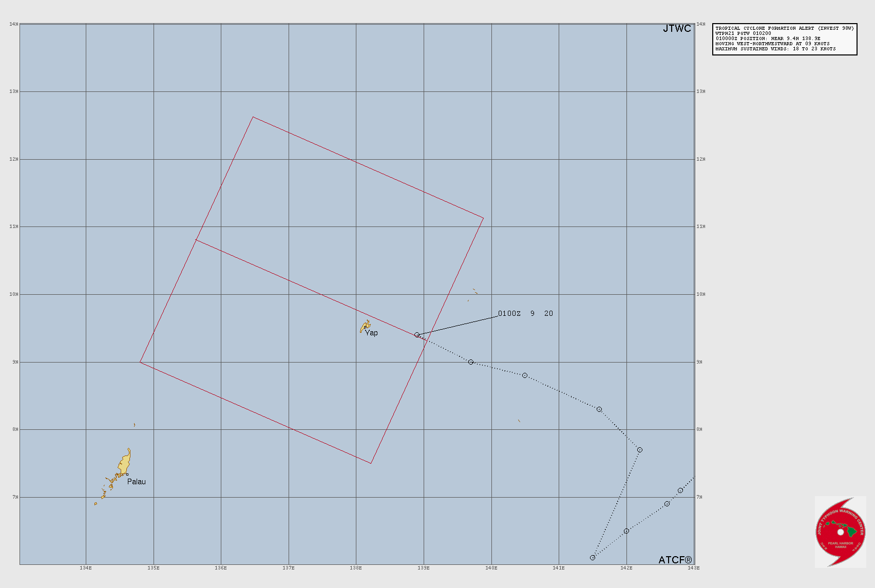
WTPN21 PGTW 010200
MSGID/GENADMIN/JOINT TYPHOON WRNCEN PEARL HARBOR HI//
SUBJ/TROPICAL CYCLONE FORMATION ALERT (INVEST 98W)//
RMKS/
1. FORMATION OF A SIGNIFICANT TROPICAL CYCLONE IS POSSIBLE WITHIN
120 NM EITHER SIDE OF A LINE FROM 9.3N 139.1E TO 10.8N 135.6E
WITHIN THE NEXT 12 TO 24 HOURS. AVAILABLE DATA DOES NOT JUSTIFY
ISSUANCE OF NUMBERED TROPICAL CYCLONE WARNINGS AT THIS TIME.
WINDS IN THE AREA ARE ESTIMATED TO BE 18 TO 23 KNOTS. METSAT
IMAGERY AT 010000Z INDICATES THAT A CIRCULATION CENTER IS LOCATED
NEAR 9.4N 138.9E. THE SYSTEM IS MOVING WEST-NORTHWESTWARD AT 09
KNOTS.
2. REMARKS: THE AREA OF CONVECTION (INVEST 98W) PREVIOUSLY LOCATED NEAR
9.0N 139.7E IS NOW LOCATED 9.4N 138.9E, APPROXIMATELY 44NM EAST OF YAP.
ANIMATED MULTISPECTRAL SATELLITE IMAGERY (MSI) DEPICTS A BROAD LOW-LEVEL
CIRCULATION CENTER (LLCC) WITH PERSISTENT DEEP CONVECTION TO THE NORTH
AND THE NEAR THE CENTER OF THE LLCC. A 312304Z 37GHZ GMI MICROWAVE IMAGE
ALSO DEPICTS DEEP CONVECTIVE CURVED BANDING NEAR THE CENTER OF THE LOW-
LEVEL ROTATION. ENVIRONMENTAL ANALYSIS REVEALS FAVORABLE CONDITIONS FOR
DEVELOPMENT FOR INVEST 98W WITH LOW VERTICAL WIND SHEAR (10-15 KNOTS),
GOOD POLEWARD OUTFLOW, AND WARM SEA SURFACE TEMPERATURES (30-31 C).
GLOBAL DETERMINISTIC AND ENSEMBLE MODELS ARE IN AGREEMENT ON STEADY
INTENSIFICATION WITH A NORTHWESTWARD TRACK OVER THE NEXT 24-36 HOURS.
MAXIMUM SUSTAINED SURFACE WINDS ARE ESTIMATED AT 18 TO 23 KNOTS.
MINIMUM SEA LEVEL PRESSURE IS ESTIMATED TO BE NEAR 1005 MB. THE
POTENTIAL FOR THE DEVELOPMENT OF A SIGNIFICANT TROPICAL CYCLONE
WITHIN THE NEXT 24 HOURS IS HIGH.
3. THIS ALERT WILL BE REISSUED, UPGRADED TO WARNING OR CANCELLED BY
020200Z.//
NNNN
0 likes
The posts in this forum are NOT official forecast and should not be used as such. They are just the opinion of the poster and may or may not be backed by sound meteorological data. They are NOT endorsed by any professional institution or storm2k.org. For official information, please refer to RSMC, NHC and NWS products.
-
mrbagyo
- Category 5
- Posts: 3923
- Age: 33
- Joined: Thu Apr 12, 2012 9:18 am
- Location: 14.13N 120.98E
- Contact:
Re: WPAC: Tropical Depression 98W
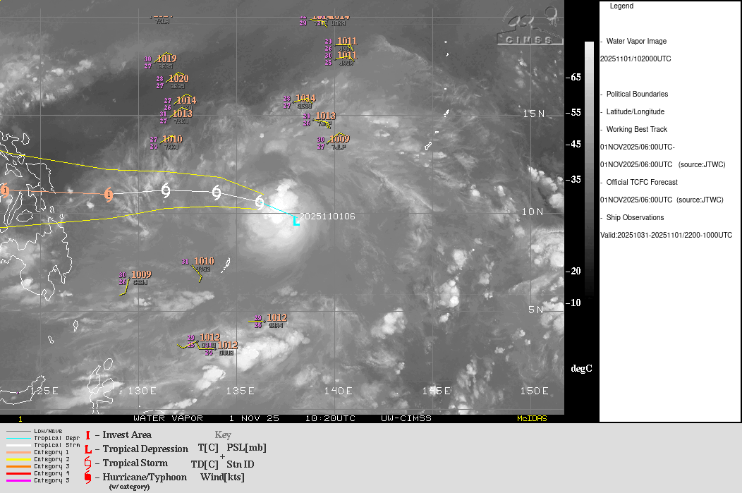
98W INVEST 251101 0000 9.4N 138.9E WPAC 20 1007
Lots of 30 knot wind barb on the northern sector
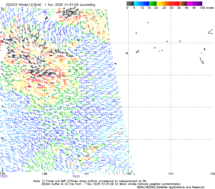
Pressure in Yap as of 0150z : 1008.8
PTYA 010150Z 03010KT 10SM -SHRA SCT016CB BKN130 OVC300 26/25 A2979 RMK SHRAB43 CB ALQDS SLP088 T02640247
Lots of 30 knot wind barb on the northern sector
Pressure in Yap as of 0150z : 1008.8
PTYA 010150Z 03010KT 10SM -SHRA SCT016CB BKN130 OVC300 26/25 A2979 RMK SHRAB43 CB ALQDS SLP088 T02640247
0 likes
The posts in this forum are NOT official forecast and should not be used as such. They are just the opinion of the poster and may or may not be backed by sound meteorological data. They are NOT endorsed by any professional institution or storm2k.org. For official information, please refer to RSMC, NHC and NWS products.
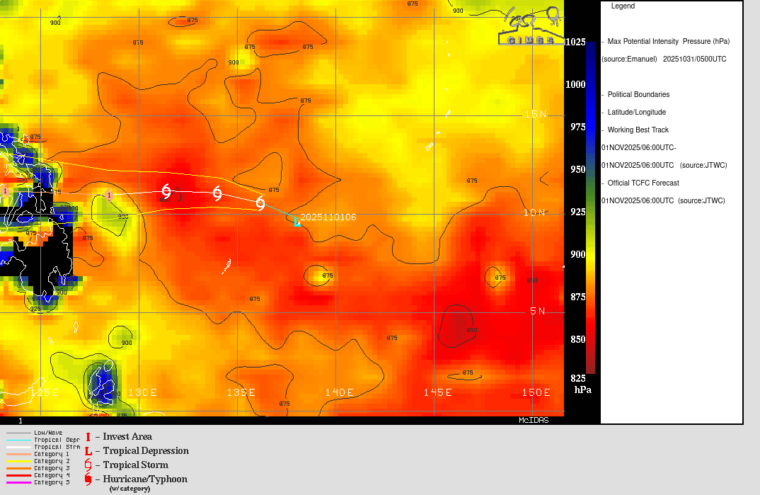
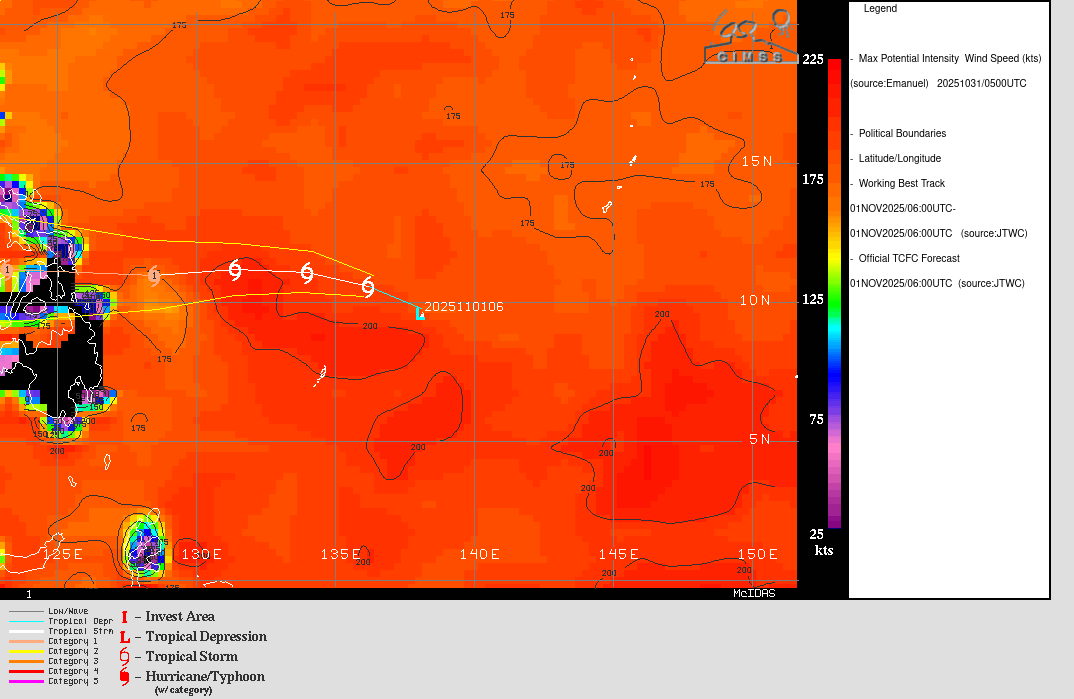
Re: WPAC: 98W - Tropical Depression

TD a
Issued at 2025/11/01 04:05 UTC
Analysis at 11/01 03 UTC
Grade TD
Scale -
Intensity -
Center position N9°30′ (9.5°)
E138°55′ (138.9°)
Direction and speed of movement NW 20 km/h (10 kt)
Central pressure 1006 hPa
Maximum sustained wind speed near center 15 m/s (30 kt)
Maximum wind gust speed 23 m/s (45 kt)
Forecast for 11/01 15 UTC
Grade TD
Intensity -
Center position of probability circle N10°30′ (10.5°)
E137°40′ (137.7°)
Direction and speed of movement NW 15 km/h (8 kt)
Central pressure 1004 hPa
Maximum sustained wind speed near center 15 m/s (30 kt)
Maximum wind gust speed 23 m/s (45 kt)
Radius of probability circle 100 km (55 NM)
Forecast for 11/02 03 UTC
Grade TS
Intensity -
Center position of probability circle N11°05′ (11.1°)
E135°30′ (135.5°)
Direction and speed of movement WNW 20 km/h (11 kt)
Central pressure 1000 hPa
Maximum sustained wind speed near center 18 m/s (35 kt)
Maximum wind gust speed 25 m/s (50 kt)
Radius of probability circle 130 km (70 NM)
Forecast for 11/03 00 UTC
Grade TS
Intensity -
Center position of probability circle N11°05′ (11.1°)
E131°30′ (131.5°)
Direction and speed of movement W 20 km/h (11 kt)
Central pressure 998 hPa
Maximum sustained wind speed near center 20 m/s (40 kt)
Maximum wind gust speed 30 m/s (60 kt)
Radius of probability circle 200 km (110 NM)
Forecast for 11/04 00 UTC
Grade STS
Intensity -
Center position of probability circle N10°50′ (10.8°)
E126°10′ (126.2°)
Direction and speed of movement W 25 km/h (13 kt)
Central pressure 990 hPa
Maximum sustained wind speed near center 25 m/s (50 kt)
Maximum wind gust speed 35 m/s (70 kt)
Radius of probability circle 260 km (140 NM)
Forecast for 11/05 00 UTC
Grade STS
Intensity -
Center position of probability circle N11°50′ (11.8°)
E121°25′ (121.4°)
Direction and speed of movement W 20 km/h (12 kt)
Central pressure 980 hPa
Maximum sustained wind speed near center 30 m/s (60 kt)
Maximum wind gust speed 45 m/s (85 kt)
Radius of probability circle 330 km (180 NM)
Radius of storm warning area 410 km (220 NM)
Forecast for 11/06 00 UTC
Grade TY
Intensity -
Center position of probability circle N12°10′ (12.2°)
E116°40′ (116.7°)
Direction and speed of movement W 20 km/h (12 kt)
Central pressure 975 hPa
Maximum sustained wind speed near center 35 m/s (65 kt)
Maximum wind gust speed 50 m/s (95 kt)
Radius of probability circle 440 km (240 NM)
Radius of storm warning area 530 km (285 NM)
0 likes
ヤンデレ女が寝取られるているのを見たい!!!
ECMWF ensemble NWPAC plots: https://ecmwfensnwpac.imgbb.com/
Multimodel NWPAC plots: https://multimodelnwpac.imgbb.com/
GFS Ensemble NWPAC plots (16 & 35 day forecast): https://gefsnwpac.imgbb.com/
Plots updated automatically
ECMWF ensemble NWPAC plots: https://ecmwfensnwpac.imgbb.com/
Multimodel NWPAC plots: https://multimodelnwpac.imgbb.com/
GFS Ensemble NWPAC plots (16 & 35 day forecast): https://gefsnwpac.imgbb.com/
Plots updated automatically
-
mrbagyo
- Category 5
- Posts: 3923
- Age: 33
- Joined: Thu Apr 12, 2012 9:18 am
- Location: 14.13N 120.98E
- Contact:
Re: WPAC: 98W - Tropical Depression
PTYA 010350Z VRB05KT 10SM -SHRA SCT016CB BKN130 OVC300 26/26 A2971 RMK CB ALQDS SLP061 T02640255
Pressure in Yap still dropping
1006.1 about an hour ago
Pressure in Yap still dropping
1006.1 about an hour ago
0 likes
The posts in this forum are NOT official forecast and should not be used as such. They are just the opinion of the poster and may or may not be backed by sound meteorological data. They are NOT endorsed by any professional institution or storm2k.org. For official information, please refer to RSMC, NHC and NWS products.
-
mrbagyo
- Category 5
- Posts: 3923
- Age: 33
- Joined: Thu Apr 12, 2012 9:18 am
- Location: 14.13N 120.98E
- Contact:
Re: WPAC: 98W - Tropical Depression
PTYA 010450Z VRB05KT 10SM -SHRA SCT016CB BKN130 OVC300 26/25 A2968 RMK CB ALQDS SLP051 T02620254
1005.1 hPa about 10 minutes ago
dropping about 1 hpa per hr.
1005.1 hPa about 10 minutes ago
dropping about 1 hpa per hr.
0 likes
The posts in this forum are NOT official forecast and should not be used as such. They are just the opinion of the poster and may or may not be backed by sound meteorological data. They are NOT endorsed by any professional institution or storm2k.org. For official information, please refer to RSMC, NHC and NWS products.
Re: WPAC: 31W - Tropical Depression
31W THIRTYONE 251101 0600 9.8N 138.1E WPAC 25 1002
0 likes
ヤンデレ女が寝取られるているのを見たい!!!
ECMWF ensemble NWPAC plots: https://ecmwfensnwpac.imgbb.com/
Multimodel NWPAC plots: https://multimodelnwpac.imgbb.com/
GFS Ensemble NWPAC plots (16 & 35 day forecast): https://gefsnwpac.imgbb.com/
Plots updated automatically
ECMWF ensemble NWPAC plots: https://ecmwfensnwpac.imgbb.com/
Multimodel NWPAC plots: https://multimodelnwpac.imgbb.com/
GFS Ensemble NWPAC plots (16 & 35 day forecast): https://gefsnwpac.imgbb.com/
Plots updated automatically
Re: WPAC: 31W - Tropical Depression
First warning

0 likes
ヤンデレ女が寝取られるているのを見たい!!!
ECMWF ensemble NWPAC plots: https://ecmwfensnwpac.imgbb.com/
Multimodel NWPAC plots: https://multimodelnwpac.imgbb.com/
GFS Ensemble NWPAC plots (16 & 35 day forecast): https://gefsnwpac.imgbb.com/
Plots updated automatically
ECMWF ensemble NWPAC plots: https://ecmwfensnwpac.imgbb.com/
Multimodel NWPAC plots: https://multimodelnwpac.imgbb.com/
GFS Ensemble NWPAC plots (16 & 35 day forecast): https://gefsnwpac.imgbb.com/
Plots updated automatically
-
mrbagyo
- Category 5
- Posts: 3923
- Age: 33
- Joined: Thu Apr 12, 2012 9:18 am
- Location: 14.13N 120.98E
- Contact:
Re: WPAC: 31W - Tropical Depression
already has a nice compact CDO

0 likes
The posts in this forum are NOT official forecast and should not be used as such. They are just the opinion of the poster and may or may not be backed by sound meteorological data. They are NOT endorsed by any professional institution or storm2k.org. For official information, please refer to RSMC, NHC and NWS products.
-
doomhaMwx

- Category 5
- Posts: 2482
- Age: 27
- Joined: Tue Apr 18, 2017 4:01 am
- Location: Baguio/Benguet, Philippines
- Contact:
Re: WPAC: 31W - Tropical Depression
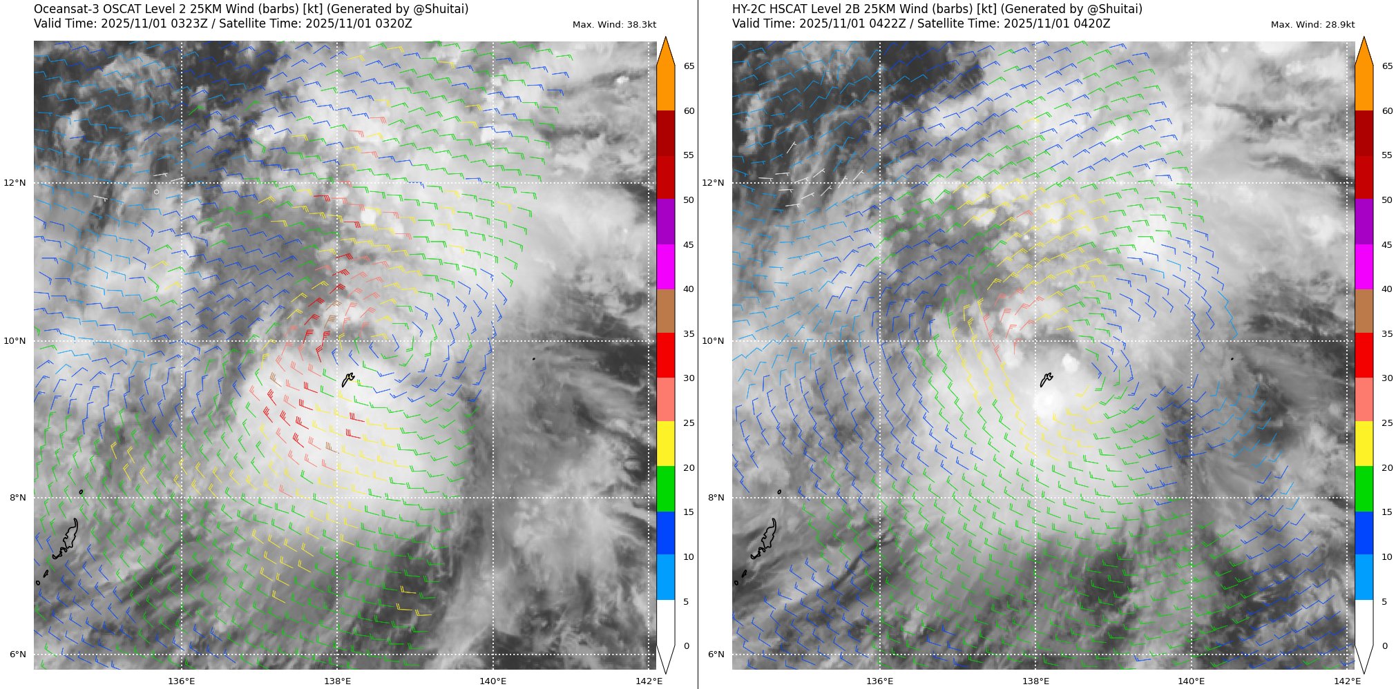
Could argue this is a tropical storm now, as scatterometer passes several hours ago indicated winds of 30-35 kts around the LLCC.
0 likes
-
xtyphooncyclonex

- Category 5
- Posts: 3888
- Age: 24
- Joined: Sat Dec 08, 2012 9:07 am
- Location: Cebu City
- Contact:
Re: WPAC: 31W - Tropical Depression
GFS is a good bit stronger this run. Now below 970 mb before landfall.
0 likes
REMINDER: My opinions that I, or any other NON Pro-Met in this forum, are unofficial. Please do not take my opinions as an official forecast and warning. I am NOT a meteorologist. Following my forecasts blindly may lead to false alarm, danger and risk if official forecasts from agencies are ignored.
-
mrbagyo
- Category 5
- Posts: 3923
- Age: 33
- Joined: Thu Apr 12, 2012 9:18 am
- Location: 14.13N 120.98E
- Contact:
Re: WPAC: 31W - Tropical Depression
0 likes
The posts in this forum are NOT official forecast and should not be used as such. They are just the opinion of the poster and may or may not be backed by sound meteorological data. They are NOT endorsed by any professional institution or storm2k.org. For official information, please refer to RSMC, NHC and NWS products.
Re: WPAC: 31W - Tropical Depression
HWRF 06z major typhoon landfall
0 likes
ヤンデレ女が寝取られるているのを見たい!!!
ECMWF ensemble NWPAC plots: https://ecmwfensnwpac.imgbb.com/
Multimodel NWPAC plots: https://multimodelnwpac.imgbb.com/
GFS Ensemble NWPAC plots (16 & 35 day forecast): https://gefsnwpac.imgbb.com/
Plots updated automatically
ECMWF ensemble NWPAC plots: https://ecmwfensnwpac.imgbb.com/
Multimodel NWPAC plots: https://multimodelnwpac.imgbb.com/
GFS Ensemble NWPAC plots (16 & 35 day forecast): https://gefsnwpac.imgbb.com/
Plots updated automatically
Re: WPAC: KALMAEGI - Tropical Storm

WTPQ50 RJTD 011200
RSMC TROPICAL CYCLONE ADVISORY
NAME TS 2525 KALMAEGI (2525) UPGRADED FROM TD
ANALYSIS
PSTN 011200UTC 10.3N 137.0E FAIR
MOVE WNW 12KT
PRES 1000HPA
MXWD 035KT
GUST 050KT
30KT 60NM
FORECAST
12HF 020000UTC 11.0N 135.8E 47NM 70%
MOVE WNW 07KT
PRES 1000HPA
MXWD 035KT
GUST 050KT
24HF 021200UTC 11.4N 133.1E 60NM 70%
MOVE W 13KT
PRES 998HPA
MXWD 040KT
GUST 060KT
48HF 031200UTC 11.2N 127.9E 130NM 70%
MOVE W 13KT
PRES 990HPA
MXWD 050KT
GUST 070KT
72HF 041200UTC 11.4N 122.7E 165NM 70%
MOVE W 13KT
PRES 990HPA
MXWD 050KT
GUST 070KT
96HF 051200UTC 12.3N 117.9E 210NM 70%
MOVE W 13KT
PRES 980HPA
MXWD 060KT
GUST 085KT
120HF 061200UTC 13.5N 112.8E 280NM 70%
MOVE W 13KT
PRES 970HPA
MXWD 070KT
GUST 100KT =
0 likes
ヤンデレ女が寝取られるているのを見たい!!!
ECMWF ensemble NWPAC plots: https://ecmwfensnwpac.imgbb.com/
Multimodel NWPAC plots: https://multimodelnwpac.imgbb.com/
GFS Ensemble NWPAC plots (16 & 35 day forecast): https://gefsnwpac.imgbb.com/
Plots updated automatically
ECMWF ensemble NWPAC plots: https://ecmwfensnwpac.imgbb.com/
Multimodel NWPAC plots: https://multimodelnwpac.imgbb.com/
GFS Ensemble NWPAC plots (16 & 35 day forecast): https://gefsnwpac.imgbb.com/
Plots updated automatically

-
mrbagyo
- Category 5
- Posts: 3923
- Age: 33
- Joined: Thu Apr 12, 2012 9:18 am
- Location: 14.13N 120.98E
- Contact:
Re: WPAC: KALMAEGI - Tropical Storm
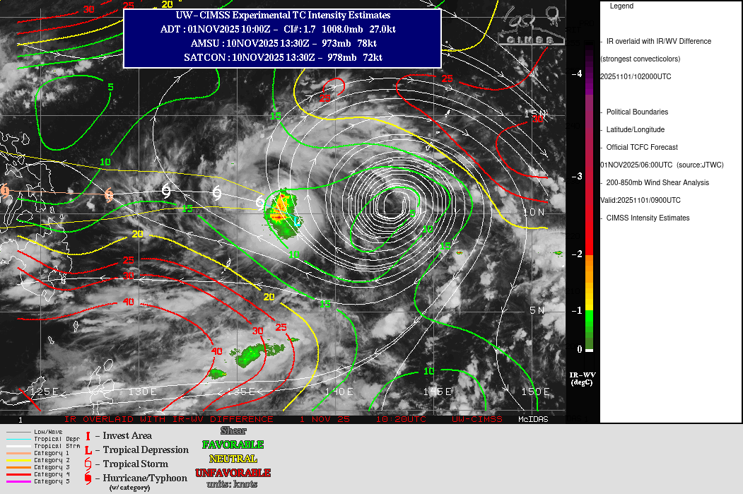
i was watching the cloud tops on the target sector earlier and some are kinda behaving like VHT. Looks to be intensifying quicker than expected. CDO looks solid already
0 likes
The posts in this forum are NOT official forecast and should not be used as such. They are just the opinion of the poster and may or may not be backed by sound meteorological data. They are NOT endorsed by any professional institution or storm2k.org. For official information, please refer to RSMC, NHC and NWS products.
-
xtyphooncyclonex
- Category 5
- Posts: 3888
- Age: 24
- Joined: Sat Dec 08, 2012 9:07 am
- Location: Cebu City
- Contact:
Re: WPAC: KALMAEGI - Tropical Storm
Kalmaegi is a very compact system. It could either fizzle or intensify pretty fast.
It's starting to spin, and I feel the JMA's forecast is too conservative. Worried we are underestimating the storm
It's starting to spin, and I feel the JMA's forecast is too conservative. Worried we are underestimating the storm
3 likes
REMINDER: My opinions that I, or any other NON Pro-Met in this forum, are unofficial. Please do not take my opinions as an official forecast and warning. I am NOT a meteorologist. Following my forecasts blindly may lead to false alarm, danger and risk if official forecasts from agencies are ignored.
Re: WPAC: KALMAEGI - Tropical Storm
Upped peak forecast before landfall

1 likes
ヤンデレ女が寝取られるているのを見たい!!!
ECMWF ensemble NWPAC plots: https://ecmwfensnwpac.imgbb.com/
Multimodel NWPAC plots: https://multimodelnwpac.imgbb.com/
GFS Ensemble NWPAC plots (16 & 35 day forecast): https://gefsnwpac.imgbb.com/
Plots updated automatically
ECMWF ensemble NWPAC plots: https://ecmwfensnwpac.imgbb.com/
Multimodel NWPAC plots: https://multimodelnwpac.imgbb.com/
GFS Ensemble NWPAC plots (16 & 35 day forecast): https://gefsnwpac.imgbb.com/
Plots updated automatically
Return to “Active Storms - WestPAC/Asia”
Who is online
Users browsing this forum: Google Adsense [Bot] and 28 guests