
WPAC: RAGASA - Typhoon
Moderators: S2k Moderators, WesternPacificWeatherMods
Forum rules

The posts in this forum are NOT official forecast and should not be used as such. They are just the opinion of the poster and may or may not be backed by sound meteorological data. They are NOT endorsed by any professional institution or STORM2K.
-
cycloneye

- Admin

- Posts: 146926
- Age: 69
- Joined: Thu Oct 10, 2002 10:54 am
- Location: San Juan, Puerto Rico
Re: WPAC: RAGASA - Tropical Storm
Is organizing at a steady rate.
0 likes
Visit the Caribbean-Central America Weather Thread where you can find at first post web cams,radars
and observations from Caribbean basin members Click Here
and observations from Caribbean basin members Click Here
-
cycloneye
- Admin
- Posts: 146926
- Age: 69
- Joined: Thu Oct 10, 2002 10:54 am
- Location: San Juan, Puerto Rico
Re: WPAC: RAGASA - Tropical Storm
FORECAST DISCUSSION: 24W IS FORECAST TO TRACK RATHER SLOWLY
NORTHWESTWARD OVER THE NEXT 48 HOURS AS THE SUBTROPICAL RIDGE TO
THE NORTH CONTINUES TO BUILD. NEAR TAU 72, THE RIDGE WILL HAVE
BUILT IN AND WILL HAVE MORE INFLUENCE ON STEERING THE VORTEX. 24W
WILL THEN INCREASE TRACK SPEEDS AS IT PASSES THROUGH THE LUZON
STRAIT WITH A MORE WEST-NORTHWESTWARD TRAJECTORY. THIS MOTION WILL
THEN PERSIST THROUGH THE REMAINDER OF THE FORECAST PERIOD AS THE
SYSTEM APPROACHES THE SOUTHERN COAST OF CHINA. REGARDING INTENSITY,
24W IS FORECAST TO RAPIDLY INTENSIFY OVER THE NEXT 48 HOURS TO
AROUND 105 KTS. ENVIRONMENTAL CONDITIONS WILL BE NEARLY PERFECT
FOR RAPID DEVELOPMENT AS THE SYSTEM TAPS INTO AN IMPROVED POLEWARD
OUTFLOW CHANNEL OVER THE NEXT 24 HOURS. A PEAK INTENSITY OF AROUND
120 KTS IS FORECAST TO OCCUR NEAR TAU 72, NORTH OF LUZON. EASTERLY
VERTICAL WIND SHEAR IS EXPECTED TO INCREASE TO 15-20 KTS AT TAU 96
AND ONWARD, CAUSING 24 TO SLIGHTLY WEAKEN AS IT HEADS FOR THE
SOUTHERN COAST OF CHINA.
MODEL DISCUSSION: NUMERICAL MODEL TRACK GUIDANCE CONTINUES TO BE IN
GOOD AGREEMENT WITH A 95 NM CROSS-TRACK SPREAD AT TAU 72 WHICH
OPENS UP TO 165 NM AT TAU 120. GFS HAS BECOME THE NORTHERNMOST
MEMBER THROUGH THE LUZON STRAIT WHILE ECMWF TRACKS THE SYSTEM
CLOSER TO NORTHERN LUZON. THE JTWC TRACK FORECAST IS PLACED CLOSE
TO THE MULTI-MODEL CONSENSUS, HEDGED SLIGHTLY CLOSER TO ECMWF, WITH
HIGH CONFIDENCE THROUGH TAU 72 AND MEDIUM CONFIDENCE THEREAFTER.
NEARLY ALL RAPID INTENSIFICATION (RI) AIDS ARE TRIGGERING THIS
MODEL RUN. MESOSCALE MODELS ARE IN GOOD AGREEMENT IN TERMS OF THE
PEAK INTENSITY OF 24W WITH HAFS-A, HWRF, AND COAMPS-TC ALL RANGING
FROM 115 TO 125 KTSAT TAU 72. GUIDANCE ALSO AGREES ON WEAKENING
AFTER TAU 72. OF NOTE, HWRF TRACKS THE SYSTEM FURTHER NORTH,
CLIPPING SOUTHERN TAIWAN, AND THEREFORE WEAKENS THE SYSTEM MUCH
MORE QUICKLY THAN HAFS-A OR COAMPS-TC. THE JTWC INTENSITY FORECAST
IS PLACED CLOSE TO THE MULTI-MODEL CONSENSUS THROUGH TAU 48, AND
THEN CLOSE TO HAFS-A FOR THE REMAINDER OF THE FORECAST PERIOD WITH
OVERALL LOW CONFIDENCE.

0 likes
Visit the Caribbean-Central America Weather Thread where you can find at first post web cams,radars
and observations from Caribbean basin members Click Here
and observations from Caribbean basin members Click Here


Re: WPAC: RAGASA - Tropical Storm
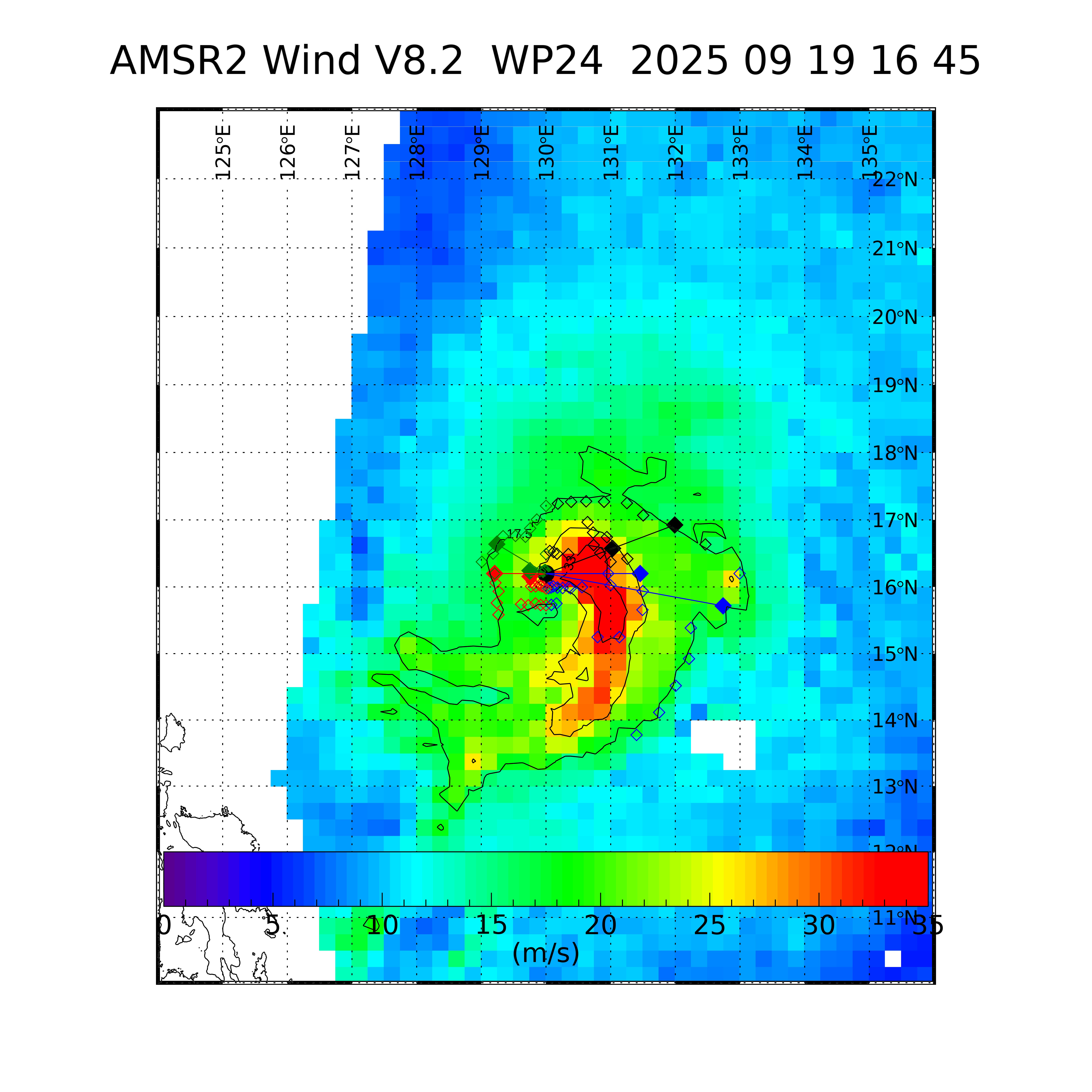
A solid band wrapping shown on a microwave pass from 6 hours ago
 |  |
0 likes
-
cycloneye
- Admin
- Posts: 146926
- Age: 69
- Joined: Thu Oct 10, 2002 10:54 am
- Location: San Juan, Puerto Rico
Re: WPAC: RAGASA - Tropical Storm
JMA up to Severe Tropical Storm:
T2518(Ragasa)
Issued at 2025/09/19 18:45 UTC
Analysis at 09/19 18 UTC
Grade STS
Scale -
Intensity -
Center position N16°35′ (16.6°)
E129°55′ (129.9°)
Direction and speed of movement WNW 15 km/h (7 kt)
Central pressure 990 hPa
Maximum sustained wind speed near center 30 m/s (55 kt)
Maximum wind gust speed 40 m/s (80 kt)
Radius of 50-kt wind area 55 km (30 NM)
Radius of 30-kt wind area 390 km (210 NM)
0 likes
Visit the Caribbean-Central America Weather Thread where you can find at first post web cams,radars
and observations from Caribbean basin members Click Here
and observations from Caribbean basin members Click Here
-
cycloneye
- Admin
- Posts: 146926
- Age: 69
- Joined: Thu Oct 10, 2002 10:54 am
- Location: San Juan, Puerto Rico
Re: WPAC: RAGASA - Tropical Storm
A. 24W (RAGASA)
B. 19/1730Z
C. 16.3N
D. 129.6E
E. THREE/HIMAWARI-9
F. T3.5/3.5
G. IR/EIR/SWIR/PRXY
H. REMARKS...8/10 BANDING ON A LOG10 SPIRAL RESULTS IN A DT OF 3.5. THE
MET EQUALS 3.5 BASED ON A RAPIDLY DEVELOPING 24-HOUR TREND AND THE PT
ALSO EQUALS 3.5. THE FT IS BASED ON THE DT.
I. ADDL POSITIONS
NIL
...LINER
B. 19/1730Z
C. 16.3N
D. 129.6E
E. THREE/HIMAWARI-9
F. T3.5/3.5
G. IR/EIR/SWIR/PRXY
H. REMARKS...8/10 BANDING ON A LOG10 SPIRAL RESULTS IN A DT OF 3.5. THE
MET EQUALS 3.5 BASED ON A RAPIDLY DEVELOPING 24-HOUR TREND AND THE PT
ALSO EQUALS 3.5. THE FT IS BASED ON THE DT.
I. ADDL POSITIONS
NIL
...LINER
0 likes
Visit the Caribbean-Central America Weather Thread where you can find at first post web cams,radars
and observations from Caribbean basin members Click Here
and observations from Caribbean basin members Click Here

Re: WPAC: RAGASA - Tropical Storm
cycloneye wrote:JMA up to Severe Tropical Storm:T2518(Ragasa)
Issued at 2025/09/19 18:45 UTC
Analysis at 09/19 18 UTC
Grade STS
Scale -
Intensity -
Center position N16°35′ (16.6°)
E129°55′ (129.9°)
Direction and speed of movement WNW 15 km/h (7 kt)
Central pressure 990 hPa
Maximum sustained wind speed near center 30 m/s (55 kt)
Maximum wind gust speed 40 m/s (80 kt)
Radius of 50-kt wind area 55 km (30 NM)
Radius of 30-kt wind area 390 km (210 NM)
Actually JMA upgraded it to STS at 1500z (intermediate time)
WTPQ51 RJTD 191500
RSMC TROPICAL CYCLONE ADVISORY
NAME STS 2518 RAGASA (2518) UPGRADED FROM TS
ANALYSIS
PSTN 191500UTC 16.5N 130.0E FAIR
MOVE W 08KT
PRES 992HPA
MXWD 050KT
GUST 070KT
RSMC TROPICAL CYCLONE ADVISORY
NAME STS 2518 RAGASA (2518) UPGRADED FROM TS
ANALYSIS
PSTN 191500UTC 16.5N 130.0E FAIR
MOVE W 08KT
PRES 992HPA
MXWD 050KT
GUST 070KT
1 likes
ヤンデレ女が寝取られるているのを見たい!!!
ECMWF ensemble NWPAC plots: https://ecmwfensnwpac.imgbb.com/
Multimodel NWPAC plots: https://multimodelnwpac.imgbb.com/
GFS Ensemble NWPAC plots (16 & 35 day forecast): https://gefsnwpac.imgbb.com/
Plots updated automatically
ECMWF ensemble NWPAC plots: https://ecmwfensnwpac.imgbb.com/
Multimodel NWPAC plots: https://multimodelnwpac.imgbb.com/
GFS Ensemble NWPAC plots (16 & 35 day forecast): https://gefsnwpac.imgbb.com/
Plots updated automatically
Re: WPAC: RAGASA - Severe Tropical Storm
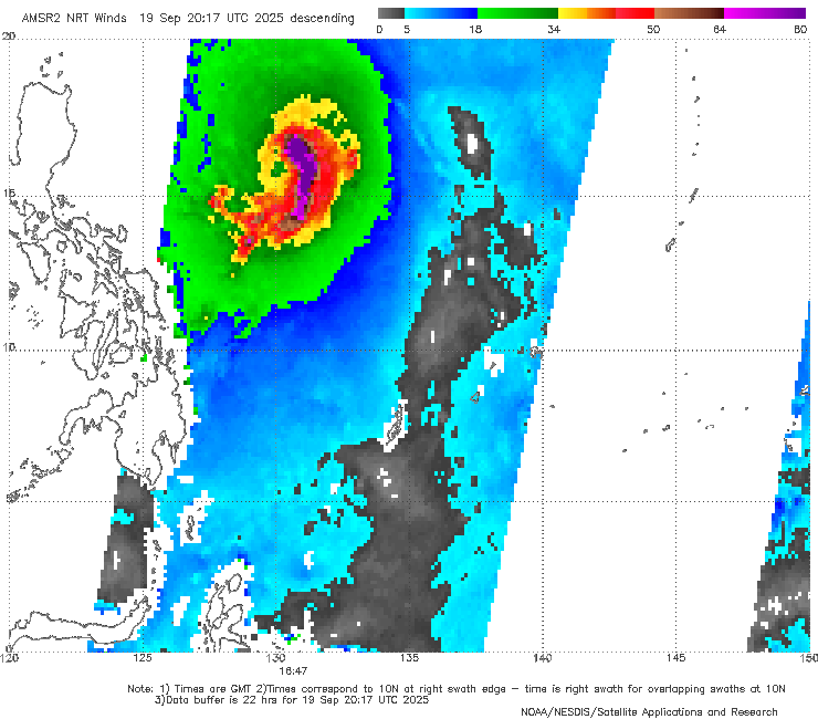
Here's 37 GHz imagery throughout the past day showing Ragasa quickly organizing over the past 12 hours, from about 12z to 17z to 21z:
The banding has very quickly wrapped around and the beginnings of a cyan ring have emerged, all signs that Ragasa is developing a structure primed for rapid intensification.
Additionally, after the latest 21z microwave pass, three hot towers have shot up around the center of the storm:

 |  |  |
The banding has very quickly wrapped around and the beginnings of a cyan ring have emerged, all signs that Ragasa is developing a structure primed for rapid intensification.
Additionally, after the latest 21z microwave pass, three hot towers have shot up around the center of the storm:
4 likes
-
mrbagyo

- Category 5

- Posts: 3785
- Age: 33
- Joined: Thu Apr 12, 2012 9:18 am
- Location: 14.13N 120.98E
- Contact:
Re: WPAC: RAGASA - Severe Tropical Storm
This should have been a typhoon as early as 18z
1 likes
The posts in this forum are NOT official forecast and should not be used as such. They are just the opinion of the poster and may or may not be backed by sound meteorological data. They are NOT endorsed by any professional institution or storm2k.org. For official information, please refer to RSMC, NHC and NWS products.
-
mrbagyo
- Category 5
- Posts: 3785
- Age: 33
- Joined: Thu Apr 12, 2012 9:18 am
- Location: 14.13N 120.98E
- Contact:
Re: WPAC: RAGASA - Severe Tropical Storm
saved loop


3 likes
The posts in this forum are NOT official forecast and should not be used as such. They are just the opinion of the poster and may or may not be backed by sound meteorological data. They are NOT endorsed by any professional institution or storm2k.org. For official information, please refer to RSMC, NHC and NWS products.


Re: WPAC: RAGASA - Severe Tropical Storm
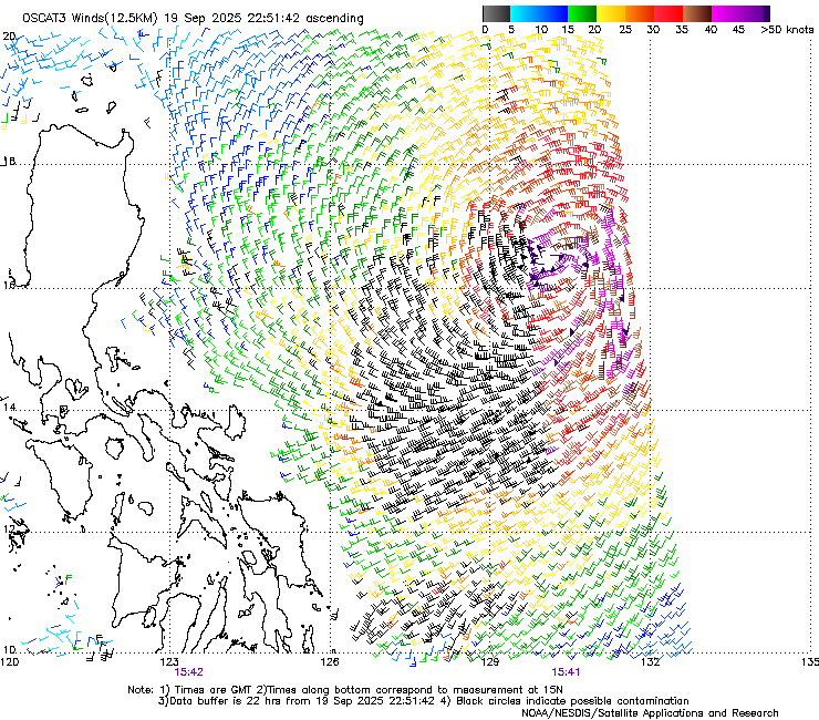
2330Z satellite bulletin from JTWC:
H. REMARKS: 40A/PBO SBC/ANMTN. CNVCTN WRAPS 1.10 ON LOG10 SPIRAL
YIELDING A DT OF 4.0. MET YIELDS 3.5. PT YIELDS 4.0. DBO DT.
YIELDING A DT OF 4.0. MET YIELDS 3.5. PT YIELDS 4.0. DBO DT.
1 likes
-
cycloneye
- Admin
- Posts: 146926
- Age: 69
- Joined: Thu Oct 10, 2002 10:54 am
- Location: San Juan, Puerto Rico
Re: WPAC: RAGASA - Severe Tropical Storm
0 likes
Visit the Caribbean-Central America Weather Thread where you can find at first post web cams,radars
and observations from Caribbean basin members Click Here
and observations from Caribbean basin members Click Here
Re: WPAC: RAGASA - Severe Tropical Storm
Unless there's an override, it looks like the JTWC doesn't note any intensification. Likewise the JMA is sticking with 55 kts as of 0100z.
Edit: This is in fact now a 65 kt typhoon.
Edit: This is in fact now a 65 kt typhoon.
24W RAGASA 250920 0000 16.3N 129.6E WPAC 65 985
1 likes
-
dexterlabio
- Category 5
- Posts: 3477
- Joined: Sat Oct 24, 2009 11:50 pm
Re: WPAC: RAGASA - Severe Tropical Storm
It is a very broad circulation but it's building a tiny, compact core.
0 likes
Personal Forecast Disclaimer:
The posts in this forum are NOT official forecast and should not be used as such. They are just the opinion of the poster and may or may not be backed by sound meteorological data. They are NOT endorsed by any professional institution or storm2k.org. For official information, please refer to the NHC and NWS products.
The posts in this forum are NOT official forecast and should not be used as such. They are just the opinion of the poster and may or may not be backed by sound meteorological data. They are NOT endorsed by any professional institution or storm2k.org. For official information, please refer to the NHC and NWS products.
-
cycloneye
- Admin
- Posts: 146926
- Age: 69
- Joined: Thu Oct 10, 2002 10:54 am
- Location: San Juan, Puerto Rico
Re: WPAC: RAGASA - Severe Tropical Storm
FORECAST DISCUSSION: TY 24W IS FORECASTED TO TRACK TO THE NORTHWEST
THROUGH TAU 48, ALONG THE SOUTHWESTERN FLANK OF THE SUBTROPICAL
STEERING RIDGE (STR) DIRECTLY TO THE NORTH. AFTER TAU 48, THE TRACK
BECOMES MORE WESTWARD AS A COMPETING EQUATORIAL RIDGE TO THE
SOUTHWEST BEGINS WEAKENING AND RETREATING WESTWARD. AS THE
EQUATORIAL RIDGE RETREATS OVER MALAYSIA, THE TRACK FOR TY 24W IS
FORECASTED TO BECOME WEST-NORTHWEST THROUGH THE LUZON STRAIT AND
INTO TAU 96 JUST SOUTH OF COASTAL SOUTHERN CHINA. BETWEEN TAU 96
AND TAU 120, THE EXPECTED TRACK BECOMES WESTWARD AS AN EXTENSION OF
THE SUBTROPICAL RIDGE TO THE EAST BEGINS TO BUILD WESTWARD, JUST
NORTH OF TY 24W. WITH REGARD TO INTENSITY, THE CONTINUED HIGHLY
FAVORABLE ENVIRONMENT IS FORECASTED TO SUPPORT FURTHER
INTENSIFICATION TO 120 KTS BY TAU 72, WITH FAVORABLE SEA SURFACE
TEMPERATURES, LOW VWS, AND STRONG OUTFLOW ALOFT. FOLLOWING TAU 72,
VWS IS FORECASTED TO INCREASE ABOVE 15 KTS WITH DRY AIR BEGINNING
TO WRAP CYCLONICALLY AROUND THE WESTERN PERIPHERY OF THE SYSTEM.
DURING THIS PERIOD, PERSISTENT LAND INTERACTION WITH SOUTHERN
COASTAL CHINA ALONG THE NORTHERN SEMICIRCLE OF TY 24W WILL BEGIN TO
WEAKEN SURFACE INTENSITIES INTO THE END OF THE FORECAST PERIOD.
MODEL DISCUSSION: NUMERICAL MODEL PREDICTION TRACK GUIDANCE IS IN
GOOD AGREEMENT THROUGHOUT THE FORECAST PERIOD, WITH A CROSS-TRACK
SPREAD OF 108 NM AT TAU 72, INCREASING TO 178 NM BY TAU 120.
BETWEEN TAU 96 AND TAU 120, ALL JTWC CONSENSUS MEMBERS ILLUSTRATE
TY 24W TO TRACK WESTWARD, RIGHT ALONG COASTAL SOUTHERN CHINA, NORTH
OF HAINAN. THE JTWC FORECAST IS ALIGNED CLOSELY WITH THE
MULTI-MODEL CONSENSUS THROUGH TAU 120, LENDING HIGH CONFIDENCE TO
THE JTWC TRACK FORECAST. WITH REGARD TO INTENSITY, THE JTWC
INTENSITY FORECAST IS ASSESSED WITH MEDIUM CONFIDENCE THROUGH TAU
120 AND PLACED JUST HIGHER THAN THE JTWC MULTI-MODEL INTENSITY
CONSENSUS DUE TO THE FORECASTED QUICK INTENSIFICATION INTO TAU 72.
0 likes
Visit the Caribbean-Central America Weather Thread where you can find at first post web cams,radars
and observations from Caribbean basin members Click Here
and observations from Caribbean basin members Click Here
-
cycloneye
- Admin
- Posts: 146926
- Age: 69
- Joined: Thu Oct 10, 2002 10:54 am
- Location: San Juan, Puerto Rico
Re: WPAC: RAGASA - Typhoon
0 likes
Visit the Caribbean-Central America Weather Thread where you can find at first post web cams,radars
and observations from Caribbean basin members Click Here
and observations from Caribbean basin members Click Here
-
mrbagyo
- Category 5
- Posts: 3785
- Age: 33
- Joined: Thu Apr 12, 2012 9:18 am
- Location: 14.13N 120.98E
- Contact:
Re: WPAC: RAGASA - Typhoon

0 likes
The posts in this forum are NOT official forecast and should not be used as such. They are just the opinion of the poster and may or may not be backed by sound meteorological data. They are NOT endorsed by any professional institution or storm2k.org. For official information, please refer to RSMC, NHC and NWS products.
-
cycloneye
- Admin
- Posts: 146926
- Age: 69
- Joined: Thu Oct 10, 2002 10:54 am
- Location: San Juan, Puerto Rico
Re: WPAC: RAGASA - Typhoon
Finnally JMA upgrades.
T2518(Ragasa)
Issued at 2025/09/20 06:45 UTC
Analysis at 09/20 06 UTC
Grade TY
Scale -
Intensity -
Center position N16°55′ (16.9°)
E129°00′ (129.0°)
Direction and speed of movement WNW 10 km/h (6 kt)
Central pressure 975 hPa
Maximum sustained wind speed near center 35 m/s (65 kt)
Maximum wind gust speed 50 m/s (95 kt)
Radius of 50-kt wind area 75 km (40 NM)
Radius of 30-kt wind area SE560 km (300 NM)
NW390 km (210 NM)
0 likes
Visit the Caribbean-Central America Weather Thread where you can find at first post web cams,radars
and observations from Caribbean basin members Click Here
and observations from Caribbean basin members Click Here
Re: WPAC: RAGASA - Typhoon
ADT raw rising
2025SEP20 060000 3.5 988.7 55.0 3.5 3.9 5.8 0.5T/hour OFF OFF OFF OFF -23.07 -71.16 EYE -99 IR 10.3 16.70 -129.05 FCST HIM-9 23.7
2025SEP20 063000 3.7 986.3 59.0 3.7 4.0 5.9 0.5T/hour OFF OFF OFF OFF -8.60 -70.64 EYE -99 IR 10.3 16.74 -129.01 FCST HIM-9 23.8
2025SEP20 071000 3.7 984.9 59.0 3.7 4.0 6.2 0.5T/hour OFF OFF OFF OFF 2.20 -71.65 EYE -99 IR 10.3 16.78 -128.96 FCST HIM-9 23.8
2025SEP20 073000 4.0 982.5 65.0 4.0 5.2 6.1 1.7T/6hr OFF OFF OFF OFF 5.00 -70.36 EYE 16 IR 10.3 16.81 -128.94 FCST HIM-9 23.9
2025SEP20 081000 4.2 978.1 69.8 4.2 5.1 6.0 1.7T/6hr OFF OFF OFF OFF -4.11 -70.23 EYE 16 IR 10.3 16.84 -128.88 FCST HIM-9 24.
0 likes
ヤンデレ女が寝取られるているのを見たい!!!
ECMWF ensemble NWPAC plots: https://ecmwfensnwpac.imgbb.com/
Multimodel NWPAC plots: https://multimodelnwpac.imgbb.com/
GFS Ensemble NWPAC plots (16 & 35 day forecast): https://gefsnwpac.imgbb.com/
Plots updated automatically
ECMWF ensemble NWPAC plots: https://ecmwfensnwpac.imgbb.com/
Multimodel NWPAC plots: https://multimodelnwpac.imgbb.com/
GFS Ensemble NWPAC plots (16 & 35 day forecast): https://gefsnwpac.imgbb.com/
Plots updated automatically
Return to “Active Storms - WestPAC/Asia”
Who is online
Users browsing this forum: aspen and 49 guests