WPAC: KALMAEGI - Post-Tropical - Discussion

Detailed discussion and tracking of all WestPac basin storms with special input from staff of our partner site, WesternPacificWeather

Moderators: S2k Moderators, WesternPacificWeatherMods

Forum rules

The posts in this forum are NOT official forecast and should not be used as such. They are just the opinion of the poster and may or may not be backed by sound meteorological data. They are NOT endorsed by any professional institution or STORM2K.

Help Support Storm2K
Message
Author
User avatar
Hurricane2022
Category 5
Category 5
Posts: 1929
Joined: Tue Aug 23, 2022 11:38 pm
Location: Araçatuba, Brazil

Re: WPAC: KALMAEGI - Tropical Storm

#41 Postby Hurricane2022 » Sat Nov 01, 2025 4:40 pm

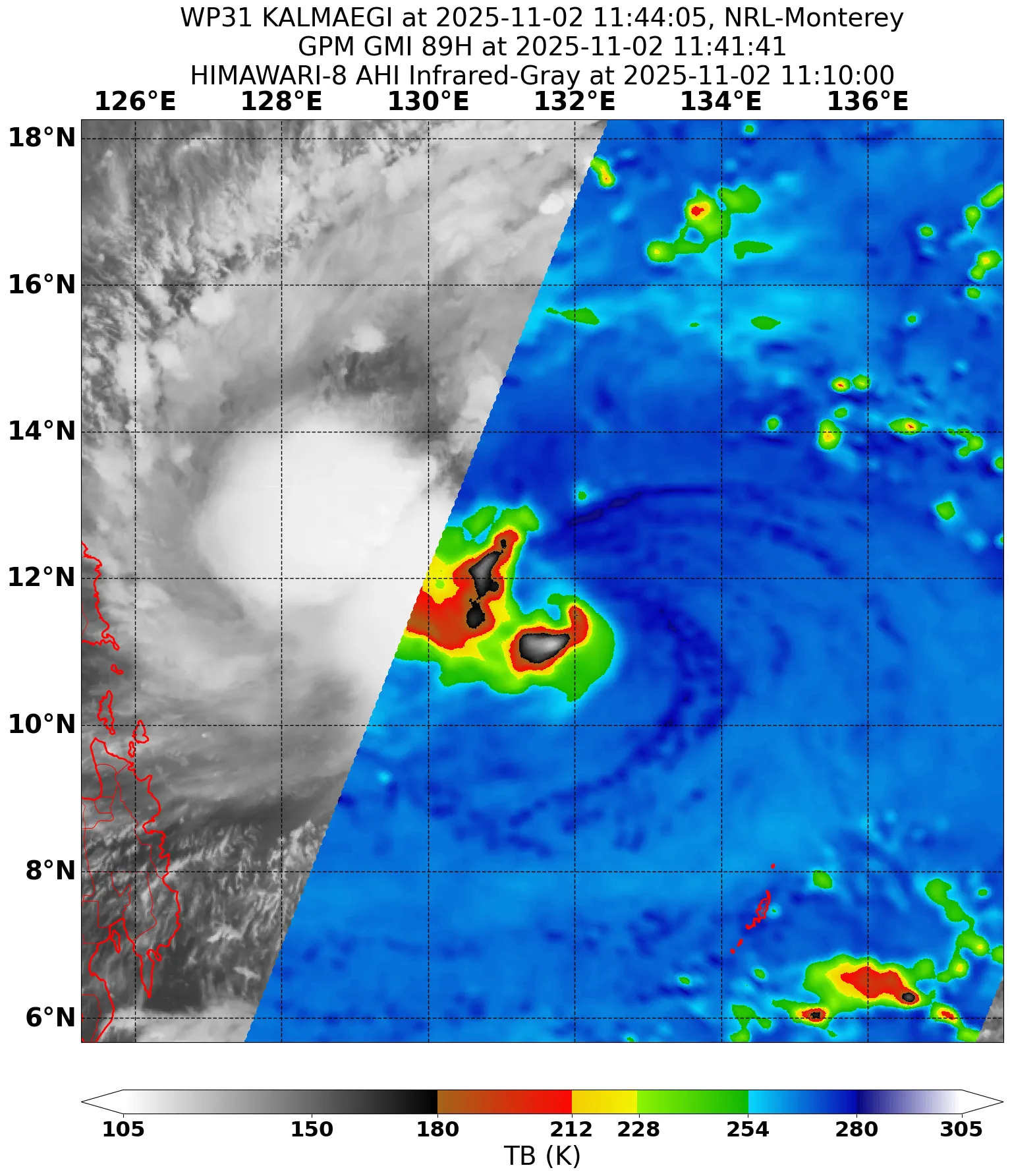
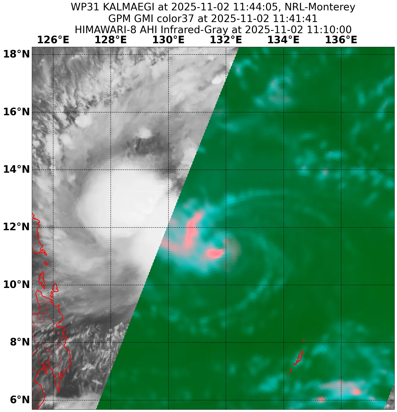
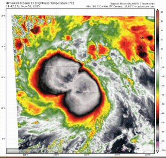
xtyphooncyclonex wrote:Kalmaegi is a very compact system. It could either fizzle or intensify pretty fast.

It's starting to spin, and I feel the JMA's forecast is too conservative. Worried we are underestimating the storm

Stay safe, xtyphooncyclonex!!!
 https://x.com/AndyHazelton/status/1984727053355438334


 https://x.com/JavaHurricane/status/1984724725218570626

0 likes   
Sorry for the bad English sometimes...!
For reliable and detailed information for any meteorological phenomenon, please consult the National Hurricane Center, Joint Typhoon Warning Center , or your local Meteo Center.

--------

ECCE OMNIA NOVA FACIAM (Ap 21,5).

User avatar
Hayabusa
Category 5
Category 5
Posts: 4778
Joined: Sun Sep 16, 2018 1:05 pm

Re: WPAC: KALMAEGI - Tropical Storm

#42 Postby Hayabusa » Sat Nov 01, 2025 4:41 pm

Looking pretty good with that curved banding, could be an STS by 00z
1 likes   
ヤンデレ女が寝取られるているのを見たい!!!
ECMWF ensemble NWPAC plots: https://ecmwfensnwpac.imgbb.com/
Multimodel NWPAC plots: https://multimodelnwpac.imgbb.com/
GFS Ensemble NWPAC plots (16 & 35 day forecast): https://gefsnwpac.imgbb.com/
Plots updated automatically

User avatar
Hayabusa
Category 5
Category 5
Posts: 4778
Joined: Sun Sep 16, 2018 1:05 pm

Re: WPAC: KALMAEGI - Tropical Storm

#43 Postby Hayabusa » Sat Nov 01, 2025 9:41 pm

New peak again could be a major by 03/18z
18z FNV3-mean has it peaking as a STY before landfall
Image
0 likes   
ヤンデレ女が寝取られるているのを見たい!!!
ECMWF ensemble NWPAC plots: https://ecmwfensnwpac.imgbb.com/
Multimodel NWPAC plots: https://multimodelnwpac.imgbb.com/
GFS Ensemble NWPAC plots (16 & 35 day forecast): https://gefsnwpac.imgbb.com/
Plots updated automatically

User avatar
xtyphooncyclonex
Category 5
Category 5
Posts: 3888
Age: 24
Joined: Sat Dec 08, 2012 9:07 am
Location: Cebu City
Contact:

Re: WPAC: KALMAEGI - Tropical Storm

#44 Postby xtyphooncyclonex » Sat Nov 01, 2025 11:44 pm

Increasingly worried for the entire Visayas, but most especially for Northern Cebu. They experienced a 6.9 earthquake a month ago and many of them do not have permanent, safe places to stay but tents. This is the last thing we could ask for.
1 likes   
REMINDER: My opinions that I, or any other NON Pro-Met in this forum, are unofficial. Please do not take my opinions as an official forecast and warning. I am NOT a meteorologist. Following my forecasts blindly may lead to false alarm, danger and risk if official forecasts from agencies are ignored.

User avatar
mrbagyo
Category 5
Category 5
Posts: 3923
Age: 33
Joined: Thu Apr 12, 2012 9:18 am
Location: 14.13N 120.98E
Contact:

Re: WPAC: KALMAEGI - Tropical Storm

#45 Postby mrbagyo » Sat Nov 01, 2025 11:56 pm

TyphoonHunter is on the prowl again
Aussie chaser also going for it

 https://twitter.com/OreboundImages/status/1984796030198825425


18z GDM expects a Cat 4 landfall at the minimum. Visayas cant catch a break
0 likes   
The posts in this forum are NOT official forecast and should not be used as such. They are just the opinion of the poster and may or may not be backed by sound meteorological data. They are NOT endorsed by any professional institution or storm2k.org. For official information, please refer to RSMC, NHC and NWS products.

User avatar
xtyphooncyclonex
Category 5
Category 5
Posts: 3888
Age: 24
Joined: Sat Dec 08, 2012 9:07 am
Location: Cebu City
Contact:

Re: WPAC: KALMAEGI - Tropical Storm

#46 Postby xtyphooncyclonex » Sun Nov 02, 2025 12:10 am

Not sure how reliable DeepMind is, but it did well with Melissa.

 https://x.com/hurricane_chase/status/1984791045373100307

0 likes   
REMINDER: My opinions that I, or any other NON Pro-Met in this forum, are unofficial. Please do not take my opinions as an official forecast and warning. I am NOT a meteorologist. Following my forecasts blindly may lead to false alarm, danger and risk if official forecasts from agencies are ignored.

User avatar
mrbagyo
Category 5
Category 5
Posts: 3923
Age: 33
Joined: Thu Apr 12, 2012 9:18 am
Location: 14.13N 120.98E
Contact:

Re: WPAC: KALMAEGI - Tropical Storm

#47 Postby mrbagyo » Sun Nov 02, 2025 12:36 am

xtyphooncyclonex wrote:Not sure how reliable DeepMind is, but it did well with Melissa.

 https://x.com/hurricane_chase/status/1984791045373100307


It's "dominating" in the Atlantic, track error is actually even better than Official NHC forecast. GFS is basically "trash"

No model still can exactly nail the intensity though
1 likes   
The posts in this forum are NOT official forecast and should not be used as such. They are just the opinion of the poster and may or may not be backed by sound meteorological data. They are NOT endorsed by any professional institution or storm2k.org. For official information, please refer to RSMC, NHC and NWS products.

ejeraldmc
Tropical Storm
Tropical Storm
Posts: 123
Joined: Thu Oct 14, 2010 6:27 pm

Re: WPAC: KALMAEGI - Tropical Storm

#48 Postby ejeraldmc » Sun Nov 02, 2025 1:04 am

The storm looks like a mess and it's accelerating towards land. I doubt it has time to become Cat 5.
0 likes   
The above post is not official and should not be used as such. It is the opinion of the poster and may or may not be backed by sound meteorological data. It is not endorsed by any professional institution or storm2k.org. For official information, please refer to the NHC and NWS products.

User avatar
mrbagyo
Category 5
Category 5
Posts: 3923
Age: 33
Joined: Thu Apr 12, 2012 9:18 am
Location: 14.13N 120.98E
Contact:

Re: WPAC: KALMAEGI - Tropical Storm

#49 Postby mrbagyo » Sun Nov 02, 2025 1:09 am

ejeraldmc wrote:The storm looks like a mess and it's accelerating towards land. I doubt it has time to become Cat 5.


Northeasterly shear seems to be bugging it
0 likes   
The posts in this forum are NOT official forecast and should not be used as such. They are just the opinion of the poster and may or may not be backed by sound meteorological data. They are NOT endorsed by any professional institution or storm2k.org. For official information, please refer to RSMC, NHC and NWS products.

dexterlabio
Category 5
Category 5
Posts: 3493
Joined: Sat Oct 24, 2009 11:50 pm

Re: WPAC: KALMAEGI - Tropical Storm

#50 Postby dexterlabio » Sun Nov 02, 2025 1:57 am

Might be some core issues but I don't think it's a total mess. It's still got a defined banding feature.
0 likes   
Personal Forecast Disclaimer:
The posts in this forum are NOT official forecast and should not be used as such. They are just the opinion of the poster and may or may not be backed by sound meteorological data. They are NOT endorsed by any professional institution or storm2k.org. For official information, please refer to the NHC and NWS products.

User avatar
doomhaMwx
Category 5
Category 5
Posts: 2482
Age: 27
Joined: Tue Apr 18, 2017 4:01 am
Location: Baguio/Benguet, Philippines
Contact:

Re: WPAC: KALMAEGI - Tropical Storm

#51 Postby doomhaMwx » Sun Nov 02, 2025 3:25 am

mrbagyo wrote:
xtyphooncyclonex wrote:Not sure how reliable DeepMind is, but it did well with Melissa.

https://x.com/hurricane_chase/status/19 ... 00307?s=19


It's "dominating" in the Atlantic, track error is actually even better than Official NHC forecast. GFS is basically "trash"

No model still can exactly nail the intensity though

Something to be wary about when it comes to DeepMind rapid intensification solutions:

 https://x.com/burgwx/status/1974664120671887522

0 likes   

User avatar
cycloneye
Admin
Admin
Posts: 148422
Age: 69
Joined: Thu Oct 10, 2002 10:54 am
Location: San Juan, Puerto Rico

Re: WPAC: KALMAEGI - Tropical Storm

#52 Postby cycloneye » Sun Nov 02, 2025 4:53 am

Image
0 likes   
Visit the Caribbean-Central America Weather Thread where you can find at first post web cams,radars
and observations from Caribbean basin members Click Here

User avatar
cycloneye
Admin
Admin
Posts: 148422
Age: 69
Joined: Thu Oct 10, 2002 10:54 am
Location: San Juan, Puerto Rico

Re: WPAC: KALMAEGI - Severe Tropical Storm

#53 Postby cycloneye » Sun Nov 02, 2025 7:48 am

JMA upgrades to Severe Tropical Storm.

Issued at 2025/11/02 12:45 UTC
Analysis at 11/02 12 UTC
Grade STS
Scale -
Intensity -
Center position N11°30′ (11.5°)
E131°05′ (131.1°)
Direction and speed of movement W 30 km/h (15 kt)
Central pressure 992 hPa
Maximum sustained wind speed near center 25 m/s (50 kt)
Maximum wind gust speed 35 m/s (70 kt)
Radius of 30-kt wind area 165 km (90 NM)
0 likes   
Visit the Caribbean-Central America Weather Thread where you can find at first post web cams,radars
and observations from Caribbean basin members Click Here

User avatar
mrbagyo
Category 5
Category 5
Posts: 3923
Age: 33
Joined: Thu Apr 12, 2012 9:18 am
Location: 14.13N 120.98E
Contact:

Re: WPAC: KALMAEGI - Severe Tropical Storm

#54 Postby mrbagyo » Sun Nov 02, 2025 9:16 am

finally a pretty decent microwave pass

Image
Image
Image
1 likes   
The posts in this forum are NOT official forecast and should not be used as such. They are just the opinion of the poster and may or may not be backed by sound meteorological data. They are NOT endorsed by any professional institution or storm2k.org. For official information, please refer to RSMC, NHC and NWS products.

User avatar
Hurricane2022
Category 5
Category 5
Posts: 1929
Joined: Tue Aug 23, 2022 11:38 pm
Location: Araçatuba, Brazil

Re: WPAC: KALMAEGI - Severe Tropical Storm

#55 Postby Hurricane2022 » Sun Nov 02, 2025 11:44 am

We need to put a speed limit warning there :lol:
Image
0 likes   

User avatar
cycloneye
Admin
Admin
Posts: 148422
Age: 69
Joined: Thu Oct 10, 2002 10:54 am
Location: San Juan, Puerto Rico

Re: WPAC: KALMAEGI - Severe Tropical Storm

#56 Postby cycloneye » Sun Nov 02, 2025 12:09 pm

0 likes   
Visit the Caribbean-Central America Weather Thread where you can find at first post web cams,radars
and observations from Caribbean basin members Click Here

User avatar
Hayabusa
Category 5
Category 5
Posts: 4778
Joined: Sun Sep 16, 2018 1:05 pm

Re: WPAC: KALMAEGI - Severe Tropical Storm

#57 Postby Hayabusa » Sun Nov 02, 2025 12:14 pm

12z Hwrf cat 4 and hfsa cat 3 before landfall
0 likes   
ヤンデレ女が寝取られるているのを見たい!!!
ECMWF ensemble NWPAC plots: https://ecmwfensnwpac.imgbb.com/
Multimodel NWPAC plots: https://multimodelnwpac.imgbb.com/
GFS Ensemble NWPAC plots (16 & 35 day forecast): https://gefsnwpac.imgbb.com/
Plots updated automatically

User avatar
mrbagyo
Category 5
Category 5
Posts: 3923
Age: 33
Joined: Thu Apr 12, 2012 9:18 am
Location: 14.13N 120.98E
Contact:

Re: WPAC: KALMAEGI - Severe Tropical Storm

#58 Postby mrbagyo » Sun Nov 02, 2025 12:21 pm

starting to look decent

Image
0 likes   
The posts in this forum are NOT official forecast and should not be used as such. They are just the opinion of the poster and may or may not be backed by sound meteorological data. They are NOT endorsed by any professional institution or storm2k.org. For official information, please refer to RSMC, NHC and NWS products.

User avatar
Hayabusa
Category 5
Category 5
Posts: 4778
Joined: Sun Sep 16, 2018 1:05 pm

Re: WPAC: KALMAEGI - Severe Tropical Storm

#59 Postby Hayabusa » Sun Nov 02, 2025 12:34 pm

Kalmaegi has 24 hours left to fully take advantage of the favorable environment
0 likes   
ヤンデレ女が寝取られるているのを見たい!!!
ECMWF ensemble NWPAC plots: https://ecmwfensnwpac.imgbb.com/
Multimodel NWPAC plots: https://multimodelnwpac.imgbb.com/
GFS Ensemble NWPAC plots (16 & 35 day forecast): https://gefsnwpac.imgbb.com/
Plots updated automatically

User avatar
Hayabusa
Category 5
Category 5
Posts: 4778
Joined: Sun Sep 16, 2018 1:05 pm

Re: WPAC: KALMAEGI - Severe Tropical Storm

#60 Postby Hayabusa » Sun Nov 02, 2025 2:10 pm

12Z FNV3 mean cat 4 landfall
0 likes   
ヤンデレ女が寝取られるているのを見たい!!!
ECMWF ensemble NWPAC plots: https://ecmwfensnwpac.imgbb.com/
Multimodel NWPAC plots: https://multimodelnwpac.imgbb.com/
GFS Ensemble NWPAC plots (16 & 35 day forecast): https://gefsnwpac.imgbb.com/
Plots updated automatically


Return to “Active Storms - WestPAC/Asia”

Who is online

Users browsing this forum: Google Adsense [Bot] and 28 guests