
WPAC: KALMAEGI - Post-Tropical - Discussion
Moderators: S2k Moderators, WesternPacificWeatherMods
Forum rules

The posts in this forum are NOT official forecast and should not be used as such. They are just the opinion of the poster and may or may not be backed by sound meteorological data. They are NOT endorsed by any professional institution or STORM2K.
-
cycloneye

- Admin

- Posts: 148422
- Age: 69
- Joined: Thu Oct 10, 2002 10:54 am
- Location: San Juan, Puerto Rico
Re: WPAC: KALMAEGI - Typhoon - Discussion
0 likes
Visit the Caribbean-Central America Weather Thread where you can find at first post web cams,radars
and observations from Caribbean basin members Click Here
and observations from Caribbean basin members Click Here
-
doomhaMwx

- Category 5

- Posts: 2482
- Age: 27
- Joined: Tue Apr 18, 2017 4:01 am
- Location: Baguio/Benguet, Philippines
- Contact:
Re: WPAC: KALMAEGI - Typhoon - Discussion
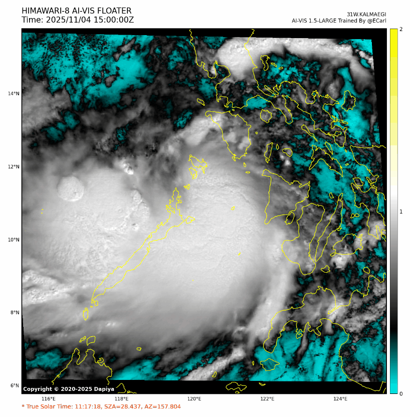
Looking at radar imagery, it seems that the tiny core threaded between Homonhon and Dinagat Islands.

0 likes
-
mrbagyo

- Category 5
- Posts: 3923
- Age: 33
- Joined: Thu Apr 12, 2012 9:18 am
- Location: 14.13N 120.98E
- Contact:
Re: WPAC: KALMAEGI - Typhoon - Discussion
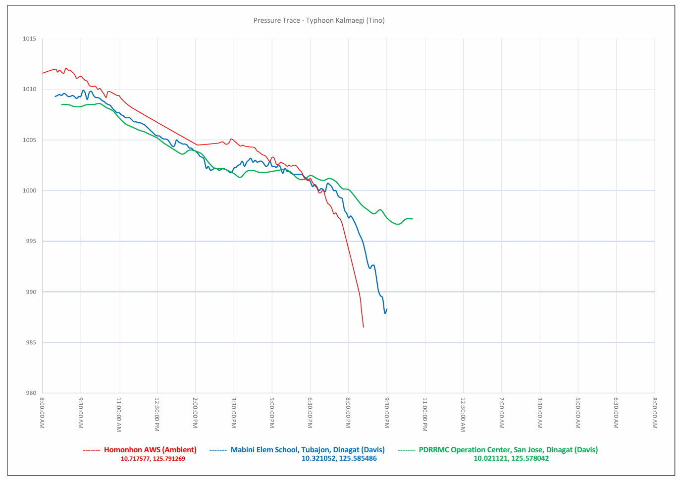
Plotted the pressure of three AWS between Homonhon and Dinagat Island.
Only the San Jose, Dinagat AWS is still online but the pressure is now rising
Lowest pressure recorded in Homonhon - 986.5 hPa at 8:35 PM
Highest wind recorded by the station - 63.7 kph / Gust - 106.6 kph (well before the eyewall) from the NW
Only the San Jose, Dinagat AWS is still online but the pressure is now rising
Lowest pressure recorded in Homonhon - 986.5 hPa at 8:35 PM
Highest wind recorded by the station - 63.7 kph / Gust - 106.6 kph (well before the eyewall) from the NW
Last edited by mrbagyo on Mon Nov 03, 2025 10:41 am, edited 1 time in total.
3 likes
The posts in this forum are NOT official forecast and should not be used as such. They are just the opinion of the poster and may or may not be backed by sound meteorological data. They are NOT endorsed by any professional institution or storm2k.org. For official information, please refer to RSMC, NHC and NWS products.
-
cycloneye
- Admin
- Posts: 148422
- Age: 69
- Joined: Thu Oct 10, 2002 10:54 am
- Location: San Juan, Puerto Rico
Re: WPAC: KALMAEGI - Typhoon - Discussion
doomhaMwx wrote:Looking at radar imagery, it seems that the tiny core threaded between Homonhon and Dinagat Islands.
https://pbs.twimg.com/media/G41u50EbUAE9yY3?format=png&name=4096x4096
Do you have the link of the radar?
0 likes
Visit the Caribbean-Central America Weather Thread where you can find at first post web cams,radars
and observations from Caribbean basin members Click Here
and observations from Caribbean basin members Click Here
-
doomhaMwx
- Category 5
- Posts: 2482
- Age: 27
- Joined: Tue Apr 18, 2017 4:01 am
- Location: Baguio/Benguet, Philippines
- Contact:
Re: WPAC: KALMAEGI - Typhoon - Discussion
cycloneye wrote:doomhaMwx wrote:Looking at radar imagery, it seems that the tiny core threaded between Homonhon and Dinagat Islands.
https://pbs.twimg.com/media/G41u50EbUAE9yY3?format=png&name=4096x4096
Do you have the link of the radar?
It's a personal plot, but radar images are also available here: https://www.panahon.gov.ph/
1 likes
-
mrbagyo
- Category 5
- Posts: 3923
- Age: 33
- Joined: Thu Apr 12, 2012 9:18 am
- Location: 14.13N 120.98E
- Contact:
Re: WPAC: KALMAEGI - Typhoon - Discussion
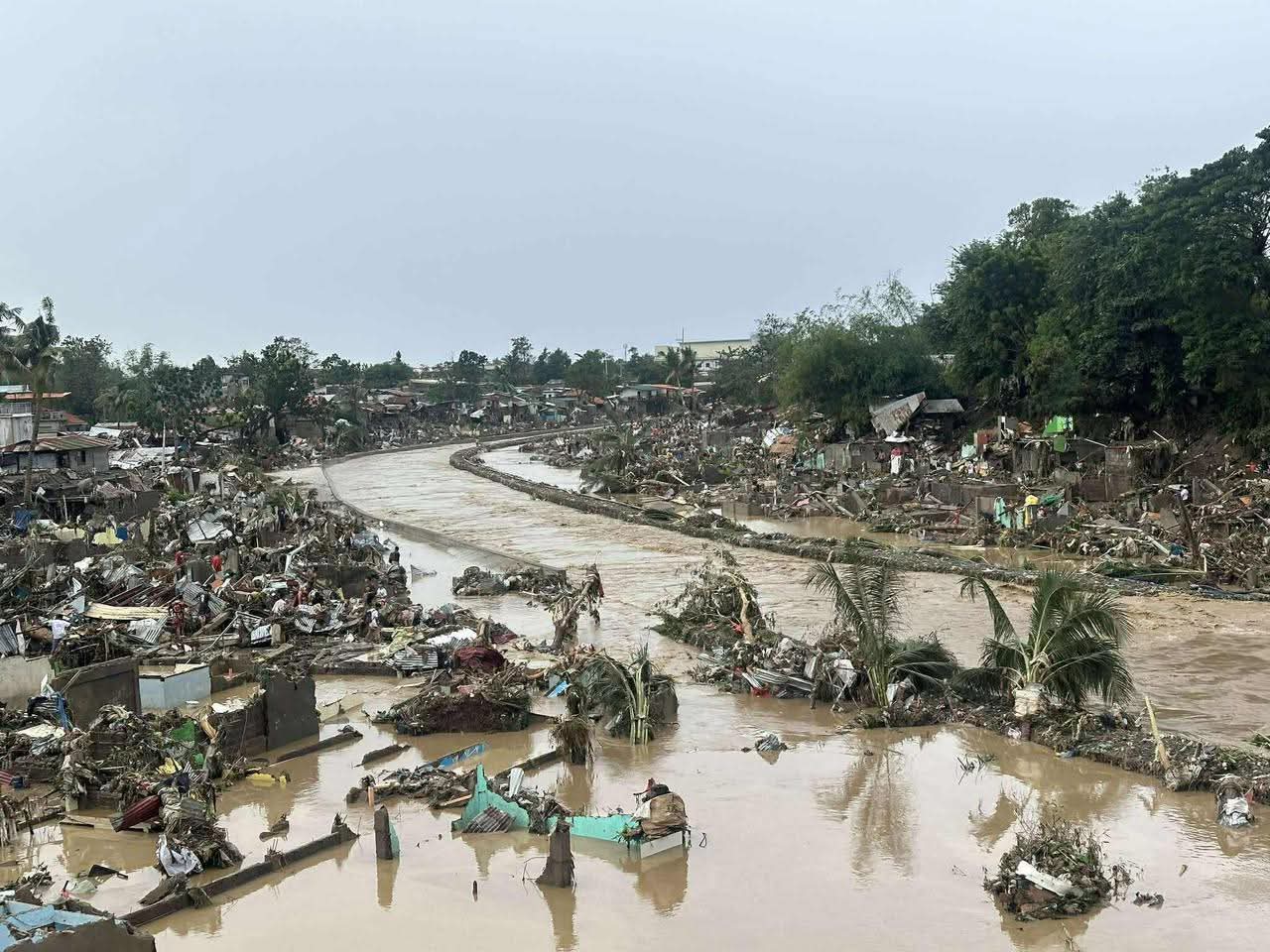
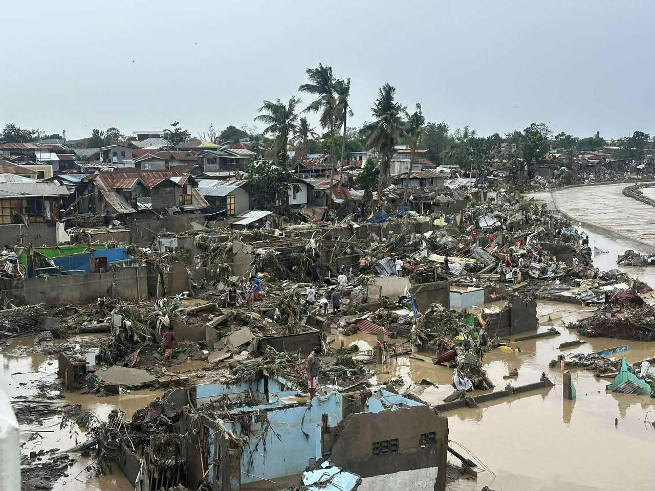
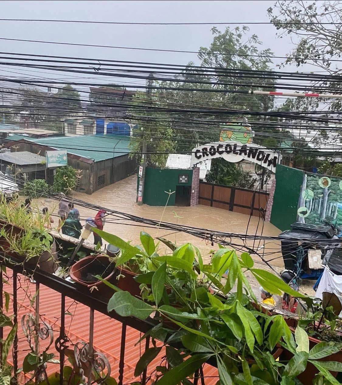
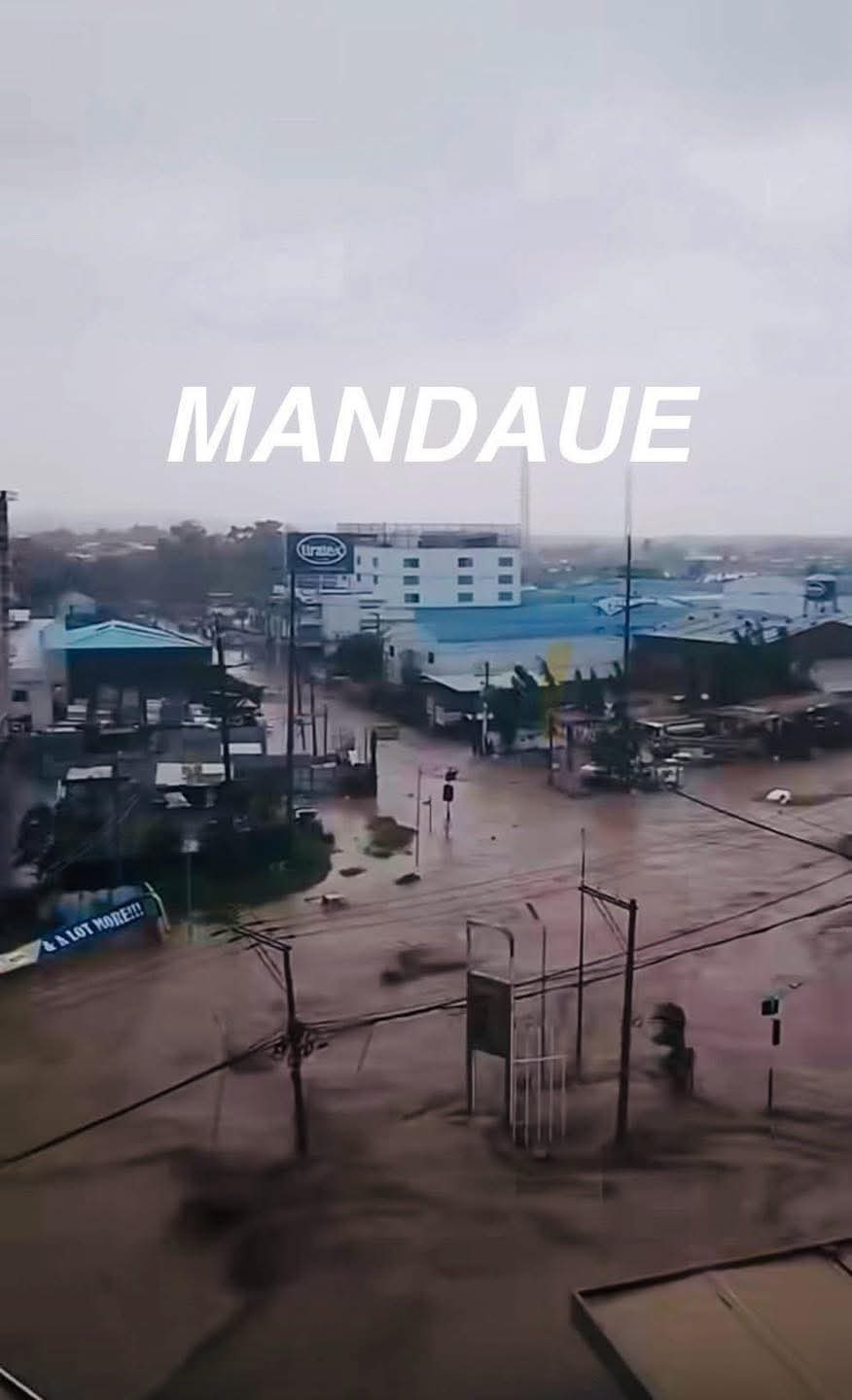
Significant flash flooding is currently happening right now in Cebu
https://twitter.com/OreboundImages/status/1985454625722679578
https://twitter.com/MarySyNimu/status/1985479469566722061
https://twitter.com/OreboundImages/status/1985454625722679578
https://twitter.com/MarySyNimu/status/1985479469566722061
1 likes
The posts in this forum are NOT official forecast and should not be used as such. They are just the opinion of the poster and may or may not be backed by sound meteorological data. They are NOT endorsed by any professional institution or storm2k.org. For official information, please refer to RSMC, NHC and NWS products.
-
xtyphooncyclonex

- Category 5
- Posts: 3888
- Age: 24
- Joined: Sat Dec 08, 2012 9:07 am
- Location: Cebu City
- Contact:
Re: WPAC: KALMAEGI - Typhoon - Discussion
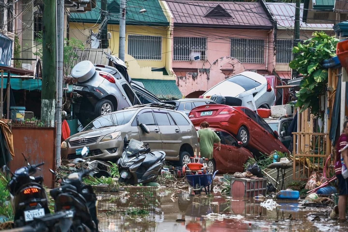
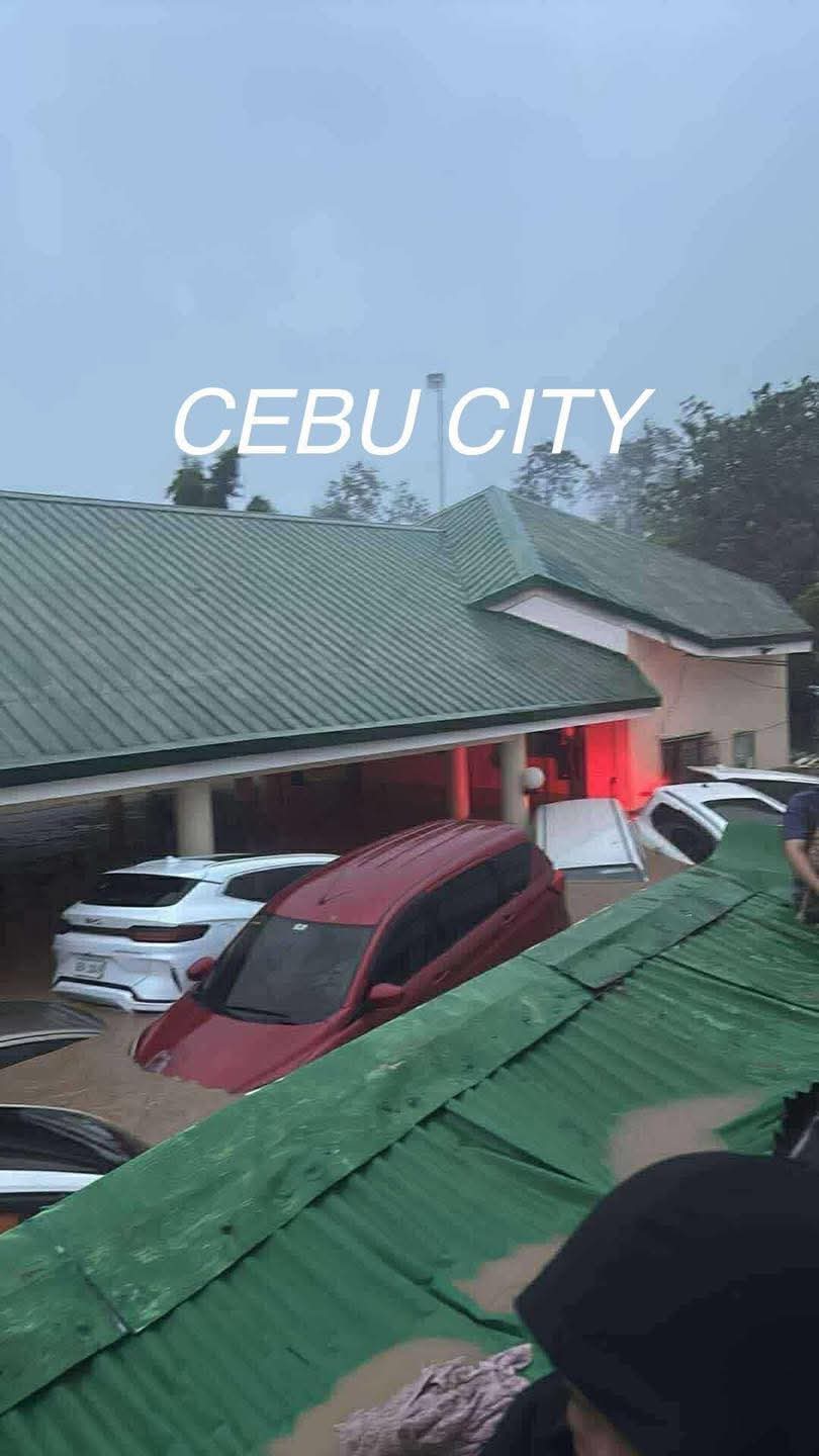
Currently in Manila, but almost all my family is in Cebu. Never seen anything like this in my life. Most of their belongings were submerged, cars were on top of each other, and there's potential for loss of life. People now advised to take medication for leptospirosis. This is unreal... Not even Ruping/Mike or Rai/Odette did this. I hope my people can recover.
It also worsens the ordeal over the north, where the storm made landfall.
It also worsens the ordeal over the north, where the storm made landfall.
1 likes
REMINDER: My opinions that I, or any other NON Pro-Met in this forum, are unofficial. Please do not take my opinions as an official forecast and warning. I am NOT a meteorologist. Following my forecasts blindly may lead to false alarm, danger and risk if official forecasts from agencies are ignored.
-
mrbagyo
- Category 5
- Posts: 3923
- Age: 33
- Joined: Thu Apr 12, 2012 9:18 am
- Location: 14.13N 120.98E
- Contact:
Re: WPAC: KALMAEGI - Typhoon - Discussion
Given the damage it brought to the Visayas (especially in Cebu Province) - I think this will be the 4th billion dollar storm of the Philippines - joining Bopha, Haiyan and Rai.
1 likes
The posts in this forum are NOT official forecast and should not be used as such. They are just the opinion of the poster and may or may not be backed by sound meteorological data. They are NOT endorsed by any professional institution or storm2k.org. For official information, please refer to RSMC, NHC and NWS products.
-
cycloneye
- Admin
- Posts: 148422
- Age: 69
- Joined: Thu Oct 10, 2002 10:54 am
- Location: San Juan, Puerto Rico
Re: WPAC: KALMAEGI - Typhoon - Discussion
0 likes
Visit the Caribbean-Central America Weather Thread where you can find at first post web cams,radars
and observations from Caribbean basin members Click Here
and observations from Caribbean basin members Click Here
-
mrbagyo
- Category 5
- Posts: 3923
- Age: 33
- Joined: Thu Apr 12, 2012 9:18 am
- Location: 14.13N 120.98E
- Contact:
Re: WPAC: KALMAEGI - Typhoon - Discussion
Kalmaegi's convection is just straight up gnarly.


1 likes
The posts in this forum are NOT official forecast and should not be used as such. They are just the opinion of the poster and may or may not be backed by sound meteorological data. They are NOT endorsed by any professional institution or storm2k.org. For official information, please refer to RSMC, NHC and NWS products.
-
xtyphooncyclonex
- Category 5
- Posts: 3888
- Age: 24
- Joined: Sat Dec 08, 2012 9:07 am
- Location: Cebu City
- Contact:
Re: WPAC: KALMAEGI - Typhoon - Discussion
Mother's family home in Mandaue was submerged. Was supposed to move back in there next month after Manila---spent my childhood and post-Rai recovery in there. Almost all belongings were wet/damaged, cars won't start. People were on top of their roofs.
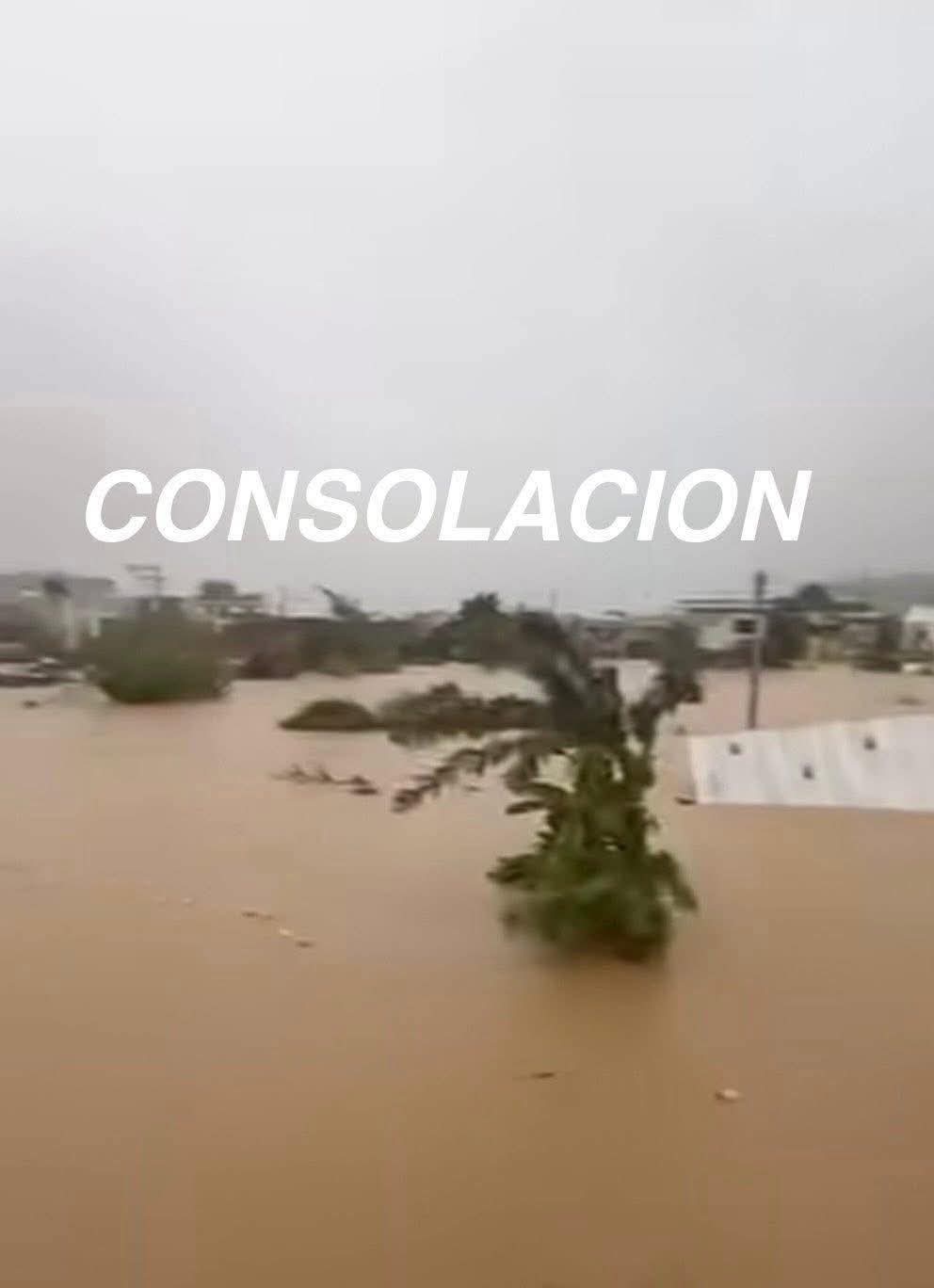
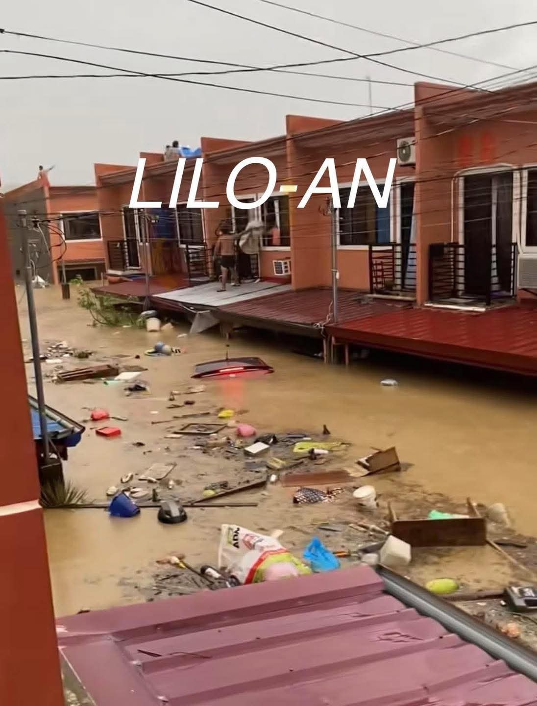
Bacayan and Villa Del Rio bore the hardest brunt in the city. Heard so many missing reports from Bacayan. My FB feed was full of distress calls within and outside of those areas. Cebu PDRRMO reported 48 fatalities so far and sadly we expect the number to rise. Talisay, Danao, Carmen, Consolacion, Mandaue, Liloan, Compostela, Pinamungajan were badly affected as well.
PAGASA says 183 mm of rain fell in Mactan, and I assume this number was even higher in Cebu and Mandaue. My go-to Weather Station in Weather Underground (Best Western Cebu) reported 120 mm, but it stopped reporting for several hours and shaved off some rainfall. As per PAGASA, one and a half month's worth of rain fell.
As per Cebuanos they do not remember any known historical precedent. My family and friends say this was the worst flood to ever hit Metro Cebu. This could also be the last time we see Kalmaegi and Tino in our naming lists. And is an eye opener for all of us.
3 likes
REMINDER: My opinions that I, or any other NON Pro-Met in this forum, are unofficial. Please do not take my opinions as an official forecast and warning. I am NOT a meteorologist. Following my forecasts blindly may lead to false alarm, danger and risk if official forecasts from agencies are ignored.
-
Hurricane2022

- Category 5
- Posts: 1929
- Joined: Tue Aug 23, 2022 11:38 pm
- Location: Araçatuba, Brazil
Re: WPAC: KALMAEGI - Typhoon - Discussion
xtyphooncyclonex wrote:Mother's family home in Mandaue was submerged. Was supposed to move back in there next month after Manila---spent my childhood and post-Rai recovery in there. Almost all belongings were wet/damaged, cars won't start. People were on top of their roofs.
Bacayan and Villa Del Rio bore the hardest brunt in the city. Heard so many missing reports from Bacayan. My FB feed was full of distress calls within and outside of those areas. Cebu PDRRMO reported 48 fatalities so far and sadly we expect the number to rise. Talisay, Danao, Carmen, Consolacion, Mandaue, Liloan, Compostela, Pinamungajan were badly affected as well.
PAGASA says 183 mm of rain fell in Mactan, and I assume this number was even higher in Cebu and Mandaue. My go-to Weather Station in Weather Underground (Best Western Cebu) reported 120 mm, but it stopped reporting for several hours and shaved off some rainfall. As per PAGASA, one and a half month's worth of rain fell.
As per Cebuanos they do not remember any known historical precedent. My family and friends say this was the worst flood to ever hit Metro Cebu. This could also be the last time we see Kalmaegi and Tino in our naming lists. And is an eye opener for all of us.
My goodness! I'm so sorry for you, your family and the affected people. I wasn't expecting such damage tbh, since Kalmaegi was moving at a significant pace and it was weaker than STYs like Rai and Haiyan... praying for the Filipinos!!!
0 likes
Sorry for the bad English sometimes...!
For reliable and detailed information for any meteorological phenomenon, please consult the National Hurricane Center, Joint Typhoon Warning Center , or your local Meteo Center.
--------
ECCE OMNIA NOVA FACIAM (Ap 21,5).
For reliable and detailed information for any meteorological phenomenon, please consult the National Hurricane Center, Joint Typhoon Warning Center , or your local Meteo Center.
--------
ECCE OMNIA NOVA FACIAM (Ap 21,5).
-
mrbagyo
- Category 5
- Posts: 3923
- Age: 33
- Joined: Thu Apr 12, 2012 9:18 am
- Location: 14.13N 120.98E
- Contact:
Re: WPAC: KALMAEGI - Typhoon - Discussion
Appears to be pummeling the tourism town of El Nido.
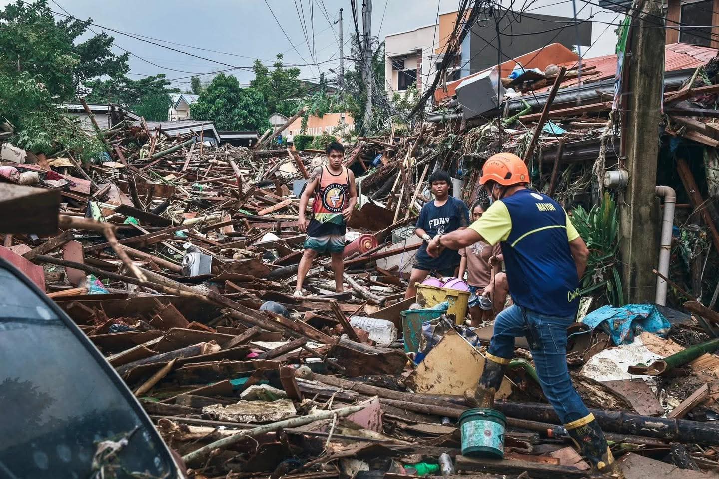
Images of damage from Cebu and Negros are gut wrenching.
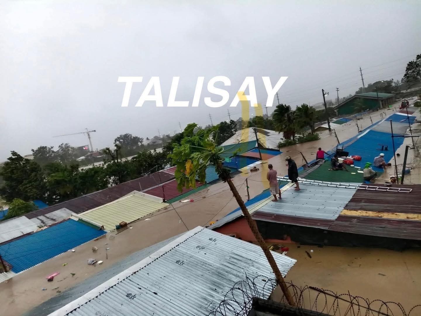
Talisay City
2 likes
The posts in this forum are NOT official forecast and should not be used as such. They are just the opinion of the poster and may or may not be backed by sound meteorological data. They are NOT endorsed by any professional institution or storm2k.org. For official information, please refer to RSMC, NHC and NWS products.
-
mrbagyo
- Category 5
- Posts: 3923
- Age: 33
- Joined: Thu Apr 12, 2012 9:18 am
- Location: 14.13N 120.98E
- Contact:
Re: WPAC: KALMAEGI - Typhoon - Discussion

0 likes
The posts in this forum are NOT official forecast and should not be used as such. They are just the opinion of the poster and may or may not be backed by sound meteorological data. They are NOT endorsed by any professional institution or storm2k.org. For official information, please refer to RSMC, NHC and NWS products.
-
dexterlabio
- Category 5
- Posts: 3493
- Joined: Sat Oct 24, 2009 11:50 pm
Re: WPAC: KALMAEGI - Typhoon - Discussion
Eye peeking on IR
0 likes
Personal Forecast Disclaimer:
The posts in this forum are NOT official forecast and should not be used as such. They are just the opinion of the poster and may or may not be backed by sound meteorological data. They are NOT endorsed by any professional institution or storm2k.org. For official information, please refer to the NHC and NWS products.
The posts in this forum are NOT official forecast and should not be used as such. They are just the opinion of the poster and may or may not be backed by sound meteorological data. They are NOT endorsed by any professional institution or storm2k.org. For official information, please refer to the NHC and NWS products.
-
mrbagyo
- Category 5
- Posts: 3923
- Age: 33
- Joined: Thu Apr 12, 2012 9:18 am
- Location: 14.13N 120.98E
- Contact:
Re: WPAC: KALMAEGI - Typhoon - Discussion

2 likes
The posts in this forum are NOT official forecast and should not be used as such. They are just the opinion of the poster and may or may not be backed by sound meteorological data. They are NOT endorsed by any professional institution or storm2k.org. For official information, please refer to RSMC, NHC and NWS products.
-
mrbagyo
- Category 5
- Posts: 3923
- Age: 33
- Joined: Thu Apr 12, 2012 9:18 am
- Location: 14.13N 120.98E
- Contact:
Re: WPAC: KALMAEGI - Typhoon - Discussion
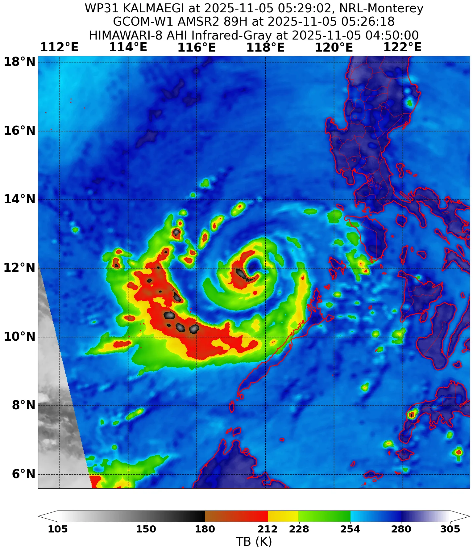
Now that the core is well established again, it can finally go major once the sun goes down.
Several members of FNV3 is hyping this up again to reach Cat 5 in SCS. Central Vietnam should pay close attention, it might challenge Yagi as the most intense landfall ever
1 likes
The posts in this forum are NOT official forecast and should not be used as such. They are just the opinion of the poster and may or may not be backed by sound meteorological data. They are NOT endorsed by any professional institution or storm2k.org. For official information, please refer to RSMC, NHC and NWS products.
-
cycloneye
- Admin
- Posts: 148422
- Age: 69
- Joined: Thu Oct 10, 2002 10:54 am
- Location: San Juan, Puerto Rico
Re: WPAC: KALMAEGI - Typhoon - Discussion
0 likes
Visit the Caribbean-Central America Weather Thread where you can find at first post web cams,radars
and observations from Caribbean basin members Click Here
and observations from Caribbean basin members Click Here


Re: WPAC: KALMAEGI - Typhoon - Discussion
JTWC is still seeing a 95kt peak as of 15Z update but on latest frames it's definitely looking better with eye clearing somewhat within the CMG ring
1 likes
Re: WPAC: KALMAEGI - Typhoon - Discussion
JMA now forecasting 935 hPa peak as CDO is getting more symmetrical. Certainly seems very dangerous for this part of Vietnam, though not sure about historical context.
TPPN10 PGTW 051827
A. TYPHOON 31W (KALMAEGI)
B. 05/1730Z
C. 13.24N
D. 114.35E
E. THREE/GK2A
F. T5.5/5.5/D1.0/24HRS STT: D0.5/03HRS
G. IR/EIR
H. REMARKS: 09A/PBO RAGGED EYE/ANMTN. B EYE SURROUNDED BY CMG
YIELDS AN E# OF 6.5. SUBTRACTED 0.5 EYE ADJUSTMENT FOR CMG TO YIELD
A DT OF 6.0. MET 5.5. PT 5.5. DBO PT.
I. ADDITIONAL POSITIONS: NONE
TIMMERMAN
3 likes
Return to “Active Storms - WestPAC/Asia”
Who is online
Users browsing this forum: Google Adsense [Bot] and 28 guests