ATL: DEBBY - Post-Tropical
Moderator: S2k Moderators
-
Evil Jeremy

- S2K Supporter

- Posts: 5463
- Age: 32
- Joined: Mon Apr 10, 2006 2:10 pm
- Location: Los Angeles, CA
-
Ivanhater

- Storm2k Moderator

- Posts: 11221
- Age: 39
- Joined: Fri Jul 01, 2005 8:25 am
- Location: Pensacola
Re: ATL: INVEST 96L - Models
Yeah..Canadian goes straight north right into Arkansas....indicative of the heat ridge breaking down.
Well see
Well see
0 likes
Michael
-
floridasun78
- Category 5

- Posts: 3755
- Joined: Sun May 17, 2009 10:16 pm
- Location: miami fl
-
caneman
Re: ATL: INVEST 96L - Models
Can anyone give me a reason why CMC is even been given any credence in this thread? Further, take a look at what is happening now and GFS has been about spot on. As Bryan Norcross stated, while the Euro has been one of the most accurate for the last couple of years, they've also had some epic fails too. As always, follow the blend.
Last edited by caneman on Sat Jun 23, 2012 12:42 am, edited 2 times in total.
0 likes

Re: ATL: INVEST 96L - Models
that is a shift for sure but still way west of the GFS stall, birth of Ernesto and east solution... 
0 likes
-
Weatherfreak000

-
Hurricaneman

- Category 5
- Posts: 7404
- Age: 45
- Joined: Tue Aug 31, 2004 3:24 pm
- Location: central florida
Re: ATL: INVEST 96L - Models
Where do you see the Euro going, staying put, shifts east towards Louisiana or more of a GFS solution towards Florida
0 likes
Re: ATL: INVEST 96L - Models
caneman wrote:Can anyone give me a reason why CMC is even been given any credence in this thread? Further, take a look at what is happening now (which isn't much) and GFS has been about spot on.
maybe because the CMC, NOGAPS, UKMET, NAM, EURO have all been showing a west solution rather than the east GFS solution. thats 5 against 1.....
0 likes
-
Kingarabian

- S2K Supporter
- Posts: 16350
- Joined: Sat Aug 08, 2009 3:06 am
- Location: Honolulu, Hawaii
Re: ATL: INVEST 96L - Models
ROCK wrote:caneman wrote:Can anyone give me a reason why CMC is even been given any credence in this thread? Further, take a look at what is happening now (which isn't much) and GFS has been about spot on.
maybe because the CMC, NOGAPS, UKMET, NAM, EURO have all been showing a west solution rather than the east GFS solution. thats 5 against 1.....
But what if the GFS is so bad ass that it can take on all 5 of those models
0 likes
RIP Kobe Bryant


Re: ATL: INVEST 96L - Models
Hurricaneman wrote:Where do you see the Euro going, staying put, shifts east towards Louisiana or more of a GFS solution towards Florida
The Euro, UKMET, and CMC tend to cluster together, so since both the UKMET and CMC have shifted north/east, so most likely will the Euro--towards the upper Texas coast. The NOGAPS is usually on the left, the GFS/GFDL/HWRF on the right of the Euro/UKMET/CMC cluster.
0 likes
Re: ATL: INVEST 96L - Models
Kingarabian wrote:ROCK wrote:caneman wrote:Can anyone give me a reason why CMC is even been given any credence in this thread? Further, take a look at what is happening now (which isn't much) and GFS has been about spot on.
maybe because the CMC, NOGAPS, UKMET, NAM, EURO have all been showing a west solution rather than the east GFS solution. thats 5 against 1.....
But what if the GFS is so bad ass that it can take on all 5 of those models
If it was so good, the NHC wouldn't be getting ready to toss it in two years.
0 likes
-
Rgv20

- S2K Supporter
- Posts: 2466
- Age: 39
- Joined: Wed Jan 05, 2011 5:42 pm
- Location: Edinburg/McAllen Tx
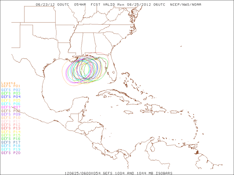
Look at the spread of the Ensembles in just 54hrs of lead time......Those contours represent 1004mb isobars 
0 likes
The following post is NOT an official forecast and should not be used as such. It is just the opinion of the poster and may or may not be backed by sound meteorological data. It is NOT endorsed by any professional institution including storm2k.org For Official Information please refer to the NHC and NWS products.
Re: ATL: INVEST 96L - Models
Kingarabian wrote:ROCK wrote:caneman wrote:Can anyone give me a reason why CMC is even been given any credence in this thread? Further, take a look at what is happening now (which isn't much) and GFS has been about spot on.
maybe because the CMC, NOGAPS, UKMET, NAM, EURO have all been showing a west solution rather than the east GFS solution. thats 5 against 1.....
But what if the GFS is so bad ass that it can take on all 5 of those models
true...it has been roided up!!.....lets see if the EURO bites...
0 likes

-
Brent
- S2K Supporter
- Posts: 38730
- Age: 37
- Joined: Sun May 16, 2004 10:30 pm
- Location: Tulsa Oklahoma
- Contact:
Re: ATL: INVEST 96L - Discussion
2am TWO, remains at 80:
SHOWER AND THUNDERSTORM ACTIVITY IS GRADUALLY INCREASING IN
ASSOCIATION WITH A LARGE LOW PRESSURE SYSTEM LOCATED ABOUT 175
MILES NORTH OF THE YUCATAN PENNISULA. RECENT SATELLITE DATA AND
SURFACE OBSERVATIONS INDICATE THAT THE CIRCULATION OF THE LOW
REMAINS QUITE BROAD WITH A LARGE AREA OF LIGHT WINDS NEAR THE
CENTER. ENVIRONMENTAL CONDITIONS ARE CONDUCIVE FOR A TROPICAL
DEPRESSION TO FORM DURING THE NEXT DAY OR SO AS THIS DISTURBANCE
DRIFTS NORTHWARD. THIS SYSTEM HAS A HIGH CHANCE...80 PERCENT...OF
BECOMING A TROPICAL CYCLONE DURING THE NEXT 48 HOURS. INTERESTS
ALONG THE UNITED STATES GULF COAST SHOULD MONITOR THE PROGRESS OF
THIS LOW THROUGH THE WEEKEND. HEAVY RAINS AND LOCALIZED FLOODING
ARE POSSIBLE ACROSS THE YUCATAN PENINSULA...WESTERN CUBA...AND
SOUTHERN FLORIDA OVER THE NEXT DAY OR SO.
0 likes
#neversummer


-
Evil Jeremy
- S2K Supporter
- Posts: 5463
- Age: 32
- Joined: Mon Apr 10, 2006 2:10 pm
- Location: Los Angeles, CA
-
stormhunter7

- Category 2

- Posts: 763
- Joined: Mon May 26, 2008 3:13 pm
- Location: Panama City Beach, Florida
- Contact:
Re: ATL: INVEST 96L - Models
did the CMC slow down? 126hrs is like next wed into southern LA?
0 likes
The following post is NOT an official forecast and should not be used as such. It is just the opinion of the poster and may or may not be backed by sound meteorological data. It is NOT endorsed by any professional institution including storm2k.org For Official Information please refer to the NHC and NWS products. http://www.nhc.noaa.gov

Who is online
Users browsing this forum: No registered users and 73 guests