ATL: ISAAC - Post-Tropical - Discussion
Moderator: S2k Moderators

Re: ATL: NINE - Tropical Depression - Discussion
Overall structure contiunes to slowly organize...Some modest NE shear presently. Once that abates on Wednesday we may have a very looking system then today...Probablly been a minimal storm since last night.
0 likes
-
latitude_20

- Tropical Storm

- Posts: 196
- Joined: Wed Jun 30, 2010 6:46 am
- Location: Tulum, Mexico
- Contact:
Re: ATL: NINE - Tropical Depression - Discussion
Product: Air Force Vortex Message (URNT12 KNHC)
Transmitted: 21st day of the month at 19:08Z
Aircraft: Air Force Aircraft (Last 3 digits of the tail number are 307)
Tropical Depression: Number 9 (flight in the North Atlantic basin)
Mission Number: 1
Observation Number: 09
A. Time of Center Fix: 21st day of the month at 18:58:40Z
B. Center Fix Coordinates: 15°20'N 53°20'W (15.3333N 53.3333W)
B. Center Fix Location: 448 miles (722 km) to the ENE (70°) from Bridgetown, Barbados.
C. Minimum Height at Standard Level: Not Available
D. Estimated (by SFMR or visually) Maximum Surface Wind: 40kts (~ 46.0mph)
E. Location of the Estimated Maximum Surface Wind: 20 nautical miles (23 statute miles) to the ENE (61°) of center fix
F. Maximum Flight Level Wind Inbound: From 146° at 44kts (From between the SE and SSE at ~ 50.6mph)
G. Location of Maximum Flight Level Wind Inbound: 21 nautical miles (24 statute miles) to the ENE (60°) of center fix
H. Minimum Sea Level Pressure: 1005mb (29.68 inHg) - Extrapolated
I. Maximum Flight Level Temp & Pressure Altitude Outside Eye: 23°C (73°F) at a pressure alt. of 242m (794ft)
J. Maximum Flight Level Temp & Pressure Altitude Inside Eye: 25°C (77°F) at a pressure alt. of 246m (807ft)
K. Dewpoint Temp (collected at same location as temp inside eye): 25°C (77°F)
K. Sea Surface Temp (collected at same location as temp inside eye): Not Available
L. Eye Character: Not Available
M. Eye Shape: Not Available
N. Fix Determined By: Penetration, Radar, Wind, Pressure and Temperature
N. Fix Level: 1,500 feet
O. Navigation Fix Accuracy: 0.02 nautical miles
O. Meteorological Accuracy: 0 nautical miles
Remarks Section - Remarks That Were Decoded...
Maximum Flight Level Wind: 44kts (~ 50.6mph) in the northeast quadrant at 18:51:00Z
Sea Level Pressure Extrapolation From: Below 1,500 feet
Remarks Section - Additional Remarks...
PRELIMINARY, DO NOT RETRANSMIT
0 likes
-
Weatherboy1

- Category 5

- Posts: 1190
- Age: 50
- Joined: Mon Jul 05, 2004 1:50 pm
- Location: Jupiter/Sarasota, FL
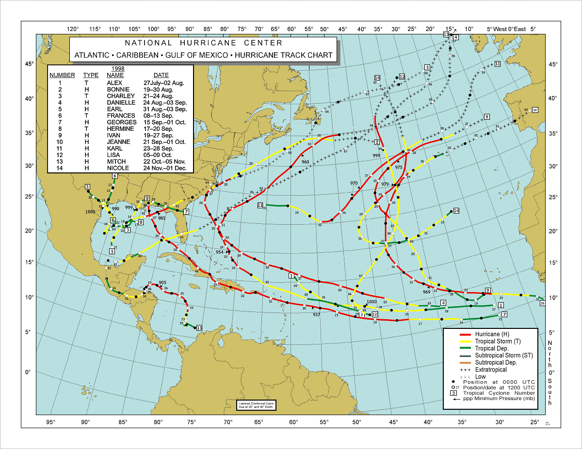
Latest modelling trending a bit more south and west, with a more gentle turn to the WNW or NW at the end of the 5-7 day period. Could this end up being a Georges (1998) kind of track I wonder?
http://www.nhc.noaa.gov/tracks/1998atl.gif
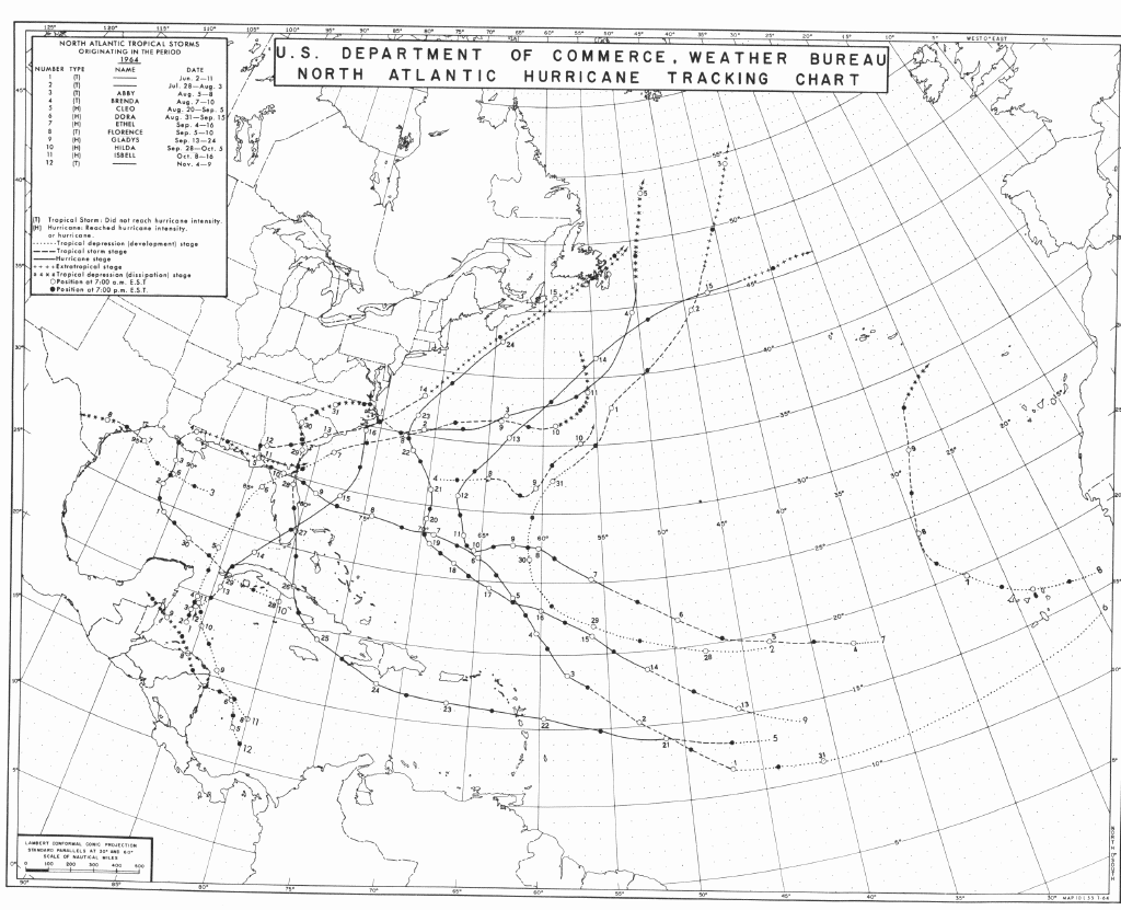
Or is it more like Cleo (1964), with a much more pronounced turn at the end of the forecast period. Hmmm!
http://www.nhc.noaa.gov/tracks/1964atl.gif
Watching and waiting as always!
http://www.nhc.noaa.gov/tracks/1998atl.gif
Or is it more like Cleo (1964), with a much more pronounced turn at the end of the forecast period. Hmmm!
http://www.nhc.noaa.gov/tracks/1964atl.gif
Watching and waiting as always!
0 likes
-
Gustywind

- Category 5
- Posts: 12334
- Joined: Mon Sep 03, 2007 7:29 am
- Location: Baie-Mahault, GUADELOUPE
000
AXNT20 KNHC 211804
TWDAT
TROPICAL WEATHER DISCUSSION
NWS NATIONAL HURRICANE CENTER MIAMI FL
205 PM EDT TUE AUG 21 2012
TROPICAL WEATHER DISCUSSION FOR NORTH AMERICA...CENTRAL
AMERICA...GULF OF MEXICO...CARIBBEAN SEA...NORTHERN SECTIONS
OF SOUTH AMERICA...AND ATLANTIC OCEAN TO THE AFRICAN COAST
FROM THE EQUATOR TO 32N. THE FOLLOWING INFORMATION IS BASED
ON SATELLITE IMAGERY...WEATHER OBSERVATIONS...RADAR...AND
METEOROLOGICAL ANALYSIS.
BASED ON 1200 UTC SURFACE ANALYSIS AND SATELLITE IMAGERY
THROUGH 1715 UTC.
...SPECIAL FEATURES...
TROPICAL DEPRESSION NINE AT 21/1800 UTC IS NEAR 15.3N 53.2W...OR
ABOUT 550 MI...885 KM E OF GUADELOUPE. THE DEPRESSION IS MOVING
WESTWARD AT 16 KT. THE ESTIMATED MINIMUM CENTRAL PRESSURE IS
1008 MB. THE MAXIMUM SUSTAINED WIND SPEEDS ARE 30 KT WITH GUSTS
TO 40 KT. PLEASE READ THE FORECAST/ADVISORY UNDER AWIPS/WMO
HEADERS MIATCMAT4/WTNT24 KNHC AND THE PUBLIC ADVISORY...
MIATCPAT4/ WTNT34 KNHC FOR MORE DETAILS. SCATTERED MODERATE TO
ISOLATED STRONG CONVECTION IS NEAR THE CENTER FROM 13N-16N
BETWEEN 52W-56W. WIDELY SCATTERED MODERATE CONVECTION IS
ELSEWHERE FROM 11N-20N BETWEEN 52W-58W. TROPICAL STORM WARNINGS
HAVE BEEN INITIATED BY THE INDIVIDUAL GOVERNMENTS OF THE EASTERN
CARIBBEAN SEA ISLANDS FROM DOMINICA AND GUADELOUPE NORTHWARD.
0 likes
-
Jevo

- S2K Supporter

- Posts: 1729
- Age: 47
- Joined: Tue Aug 03, 2004 8:45 pm
- Location: The Flemish Cap
- Contact:
With the 12Z Euro this board is going to be hoppin soon
Latest satellite derived winds look pretty interesting

Latest satellite derived winds look pretty interesting
0 likes
Disclaimer: 50% of the time I have no clue of what I am talking about. Chances are I am taking a less than educated guess that sounds good because 10 years ago I stole Mike Watkins book 'The Hurricane and its Impact'. For official information please direct yourself to the NHC and their cadre of weather geniuses.
-
Blown Away

- S2K Supporter
- Posts: 10253
- Joined: Wed May 26, 2004 6:17 am
Re: ATL: NINE - Tropical Depression - Discussion
0 likes
Hurricane Eye Experience: David 79, Irene 99, Frances 04, Jeanne 04, Wilma 05… Hurricane Brush Experience: Andrew 92, Erin 95, Floyd 99, Matthew 16, Irma 17, Ian 22, Nicole 22…
-
cycloneye

- Admin

- Posts: 149203
- Age: 69
- Joined: Thu Oct 10, 2002 10:54 am
- Location: San Juan, Puerto Rico
Re: ATL: NINE - Tropical Depression - Discussion
12z Best Track up to Tropical Storm Issac
AL, 09, 2012082118, , BEST, 0, 153N, 532W, 35, 1005, TS
AL, 09, 2012082118, , BEST, 0, 153N, 532W, 35, 1005, TS
0 likes
Visit the Caribbean-Central America Weather Thread where you can find at first post web cams,radars
and observations from Caribbean basin members Click Here
and observations from Caribbean basin members Click Here
Re: ATL: NINE - Tropical Depression - Discussion
Isaac (sp)...
P.S. Isaac was the oldest of the Biblical prophets...
P.S. Isaac was the oldest of the Biblical prophets...
Last edited by Frank2 on Tue Aug 21, 2012 2:31 pm, edited 3 times in total.
0 likes
-
SeminoleWind

- Category 1

- Posts: 359
- Age: 51
- Joined: Wed Jun 02, 2010 8:37 pm
- Location: Lake County Florida
Re: ATL: NINE - Tropical Depression - Discussion
cycloneye wrote:12z Best Track up to Tropical Storm Issac
[b]AL, 09, 2012082118, , BEST, 0, 153N, 532W, 35, 1005, TS
[/b]
was wondering how long it would take since they have found some T.S. winds in there.
0 likes
This post is NOT an official forecast and should not be used as such. It is just the opinion of the poster and may or may not be backed by sound meteorological data. It is NOT endorsed by any professional institution including storm2k.org For Official Information please refer to the NHC and NWS products.
-
Weatherboy1
- Category 5
- Posts: 1190
- Age: 50
- Joined: Mon Jul 05, 2004 1:50 pm
- Location: Jupiter/Sarasota, FL
Sooooooo looks like we've got our "I" storm at 5 p.m. eh? Gotta love recon! I still don't think we're going to see rapid intensification or anything, but steady strengthening seems like a decent bet. Worth pointing out it's about to cross over the 29 degrees Celsius (84 degrees F) line so SSTs are only getting warmer. If it can mix out more of that dry air, it's gonna pop. My opinion, as always ...
0 likes
-
latitude_20
- Tropical Storm
- Posts: 196
- Joined: Wed Jun 30, 2010 6:46 am
- Location: Tulum, Mexico
- Contact:
-
tolakram
- Admin
- Posts: 20176
- Age: 62
- Joined: Sun Aug 27, 2006 8:23 pm
- Location: Florence, KY (name is Mark)
Re: ATL: NINE - Tropical Depression - Discussion
latitude_20 wrote:So an upgrade is imminent, correct?
NHC makes the final decision and it will be officially upgraded once the advisory comes out.
0 likes
M a r k
- - - - -
Join us in chat: Storm2K Chatroom Invite. Android and IOS apps also available.
The posts in this forum are NOT official forecasts and should not be used as such. Posts are NOT endorsed by any professional institution or STORM2K.org. For official information and forecasts, please refer to NHC and NWS products.
Re: ATL: NINE - Tropical Depression - Discussion
latitude_20 wrote:So an upgrade is imminent, correct?
99.9%
0 likes
-
Gustywind
- Category 5
- Posts: 12334
- Joined: Mon Sep 03, 2007 7:29 am
- Location: Baie-Mahault, GUADELOUPE
Even the journalists who are not forecasters... seems very confident about Issac arrival in Guadeloupe 
 . Let's continue to monitor closely the situation as something is surely cooking not so far from the Leewards.
WEATHER GUADELOUPE
Yellow vigilance Isaac closer
franceantilles.fr 21.08.2012
 http://www.microsofttranslator.com/bv.a ... 183571.php
11 AM, the center was located about 930 km east of Guadeloupe. The depression is expected to strengthen to tropical storm stage today. Its planned trajectory through Guadeloupe, the center of the phenomenon should reach our archipelago in afternoon or evening of Wednesday.
The depression is expected to strengthen to tropical storm stage today. Its planned trajectory through the Guadeloupe, the center of the phenomenon should reach our archipelago in afternoon or evening of Wednesday. 11 AM, the Center was located about 930 km east of Guadeloupe.
First stormy showers arrived as early as the next night and continue into Wednesday. They intensify and become more sustainable in the night of Wednesday to Thursday and Thursday day. Accumulations of rainfall may exceed 100 mm / 24 hours at many points, as well Wednesday as Thursday.
Today and tomorrow, the wind blows moderately from Northeast but temporarily boosts grain stormy passage. The wind became more sustained after the passage of the depression centre on the night of Wednesday to Thursday. He then swung South-South-East, and blows between 50 and 60 km/h of average with gusts in the order of 80-100 km/h.
The sea is widening gradually tomorrow during the day. Average lows are around 2 m 50 Wednesday evening, then 3 m 3 m 50 Thursday morning with waves max 6 m in a swell of Northeast and then East. Cross-swell phenomena make the chaotic sea. In Caribbean, hollow of 2 m are expected Thursday in a main Southeast swell.
Heavy rains expected may cause disturbances: flooding, overflow of streams and gullies,... and make difficult traffic conditions.
WEATHER GUADELOUPE
Yellow vigilance Isaac closer
franceantilles.fr 21.08.2012
11 AM, the center was located about 930 km east of Guadeloupe. The depression is expected to strengthen to tropical storm stage today. Its planned trajectory through Guadeloupe, the center of the phenomenon should reach our archipelago in afternoon or evening of Wednesday.
The depression is expected to strengthen to tropical storm stage today. Its planned trajectory through the Guadeloupe, the center of the phenomenon should reach our archipelago in afternoon or evening of Wednesday. 11 AM, the Center was located about 930 km east of Guadeloupe.
First stormy showers arrived as early as the next night and continue into Wednesday. They intensify and become more sustainable in the night of Wednesday to Thursday and Thursday day. Accumulations of rainfall may exceed 100 mm / 24 hours at many points, as well Wednesday as Thursday.
Today and tomorrow, the wind blows moderately from Northeast but temporarily boosts grain stormy passage. The wind became more sustained after the passage of the depression centre on the night of Wednesday to Thursday. He then swung South-South-East, and blows between 50 and 60 km/h of average with gusts in the order of 80-100 km/h.
The sea is widening gradually tomorrow during the day. Average lows are around 2 m 50 Wednesday evening, then 3 m 3 m 50 Thursday morning with waves max 6 m in a swell of Northeast and then East. Cross-swell phenomena make the chaotic sea. In Caribbean, hollow of 2 m are expected Thursday in a main Southeast swell.
Heavy rains expected may cause disturbances: flooding, overflow of streams and gullies,... and make difficult traffic conditions.
0 likes
-
floridasun78
- Category 5
- Posts: 3755
- Joined: Sun May 17, 2009 10:16 pm
- Location: miami fl
Re: ATL: NINE - Tropical Depression - Discussion
you all still think south fl could be in cone by thur?
0 likes
-
Stormlover2012
- Category 1
- Posts: 262
- Joined: Sat Jun 23, 2012 11:03 am
-
otowntiger
- Category 5
- Posts: 1932
- Joined: Tue Aug 31, 2004 7:06 pm
Re: ATL: NINE - Tropical Depression - Discussion
cycloneye wrote:12z Best Track up to Tropical Storm Issac
AL, 09, 2012082118, , BEST, 0, 153N, 532W, 35, 1005, TS
Time for a spelling lesson everyone! Since I have a son by the same name I've had to learn this the hard way: No matter how badly you'll want to put 2 's's it is only one, but 2 'a's. 'Isaac'. Thanks. Now back to your regularly schedulred programming.
0 likes

Re: ATL: NINE - Tropical Depression - Discussion
GUSTY -
and all on the islands - stay safe and check in when you can.
and all on the islands - stay safe and check in when you can.
0 likes
-
SouthFLTropics

- Category 5
- Posts: 4258
- Age: 50
- Joined: Thu Aug 14, 2003 8:04 am
- Location: Port St. Lucie, Florida
Re: ATL: NINE - Tropical Depression - Discussion
floridasun78 wrote:you all still think south fl could be in cone by thur?
I think South Florida will be in the cone by 11:00PM tonight...The question is whether or not we will stay there. I have been in the cone many times only to have it shift and go elsewhere. 5 day cone is normally right where you want to be.
SFT
0 likes
Fourth Generation Florida Native
Personal Storm History: David 79, Andrew 92, Erin 95, Floyd 99, Irene 99, Frances 04, Jeanne 04, Wilma 05, Matthew 16, Irma 17, Ian 22, Nicole 22, Milton 24
Personal Storm History: David 79, Andrew 92, Erin 95, Floyd 99, Irene 99, Frances 04, Jeanne 04, Wilma 05, Matthew 16, Irma 17, Ian 22, Nicole 22, Milton 24
Who is online
Users browsing this forum: No registered users and 1 guest