ATL: DEBBY - Post-Tropical
Moderator: S2k Moderators
- stormhunter7
- Category 2

- Posts: 763
- Joined: Mon May 26, 2008 3:13 pm
- Location: Panama City Beach, Florida
- Contact:
Re: ATL: INVEST 96L - Models
Euro appears its going west in 00z.. up 72hrs
0 likes
The following post is NOT an official forecast and should not be used as such. It is just the opinion of the poster and may or may not be backed by sound meteorological data. It is NOT endorsed by any professional institution including storm2k.org For Official Information please refer to the NHC and NWS products. http://www.nhc.noaa.gov
Re: ATL: INVEST 96L - Models
ROCK wrote:west to Texas again....996mb TS probably....
Actually 992 mb
0 likes
Re: ATL: INVEST 96L - Models
so still a split camp tonight....maybe tomorrow will bring a consensus:lol:
0 likes
- Evil Jeremy
- S2K Supporter

- Posts: 5463
- Age: 32
- Joined: Mon Apr 10, 2006 2:10 pm
- Location: Los Angeles, CA
Re: ATL: INVEST 96L - Models
EURO 120 hours out, already inland after Texas landfall.


0 likes
Frances 04 / Jeanne 04 / Katrina 05 / Wilma 05 / Fay 08 / Debby 12 / Andrea 13 / Colin 16 / Hermine 16 / Matthew 16 / Irma 17
-
caneman
Re: ATL: INVEST 96L - Models
Looks like Euro is taking it further North on this run before going West?
0 likes
Re: ATL: INVEST 96L - Models
What bothers me is how the EURO negatively align the high pressure on Wednesday over the Midwest, so that Debbie starts to curve north at the end. If she is delayed just a tad or the high is slightly weaker as in the last CMC run, it will be moving northwest towards the upper Texas coast at that time.
0 likes
- Rgv20
- S2K Supporter

- Posts: 2466
- Age: 39
- Joined: Wed Jan 05, 2011 5:42 pm
- Location: Edinburg/McAllen Tx
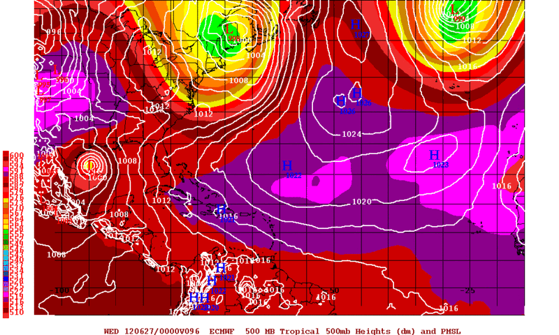
0zECMWF and UKMET almost identical thru 96hrs than diverge from their.....(UKMET has it in the Houston area and ECMWF to South Texas)
0zECMWF forecast valid for Tuesday Evening.

0zECMWF forecast valid for Tuesday Evening.

0 likes
The following post is NOT an official forecast and should not be used as such. It is just the opinion of the poster and may or may not be backed by sound meteorological data. It is NOT endorsed by any professional institution including storm2k.org For Official Information please refer to the NHC and NWS products.
Re: ATL: INVEST 96L - Discussion
That little naked swirl that we were laughing at earlier is developing some beautiful low cloud banding structures now. The cloud tops around the center have not started really cooling yet, but it is developing a nice compact organized structure. I wonder if this will turn out to be the new center by tomorrow.
0 likes
- stormhunter7
- Category 2

- Posts: 763
- Joined: Mon May 26, 2008 3:13 pm
- Location: Panama City Beach, Florida
- Contact:
Re: ATL: INVEST 96L - Discussion
upper winds over that vortex came hauling by.. looks like dry air over it is filling it with moisture in upper levels...
http://www.ssd.noaa.gov/goes/east/gmex/flash-wv.html (less black over the vortex) almost want to say there is ULL trying to pop, to se of Houston?
http://www.ssd.noaa.gov/goes/east/gmex/flash-wv.html (less black over the vortex) almost want to say there is ULL trying to pop, to se of Houston?
0 likes
The following post is NOT an official forecast and should not be used as such. It is just the opinion of the poster and may or may not be backed by sound meteorological data. It is NOT endorsed by any professional institution including storm2k.org For Official Information please refer to the NHC and NWS products. http://www.nhc.noaa.gov
Re: ATL: INVEST 96L - Discussion
stormhunter7 wrote:upper winds over that vortex came hauling by.. looks like dry air over it is filling it with moisture in upper levels...
http://www.ssd.noaa.gov/goes/east/gmex/flash-wv.html (less black over the vortex) almost want to say there is ULL trying to pop, to se of Houston?
nice low level convergence going on now....
http://tropic.ssec.wisc.edu/real-time/w ... oom=&time=
0 likes
- Jevo
- S2K Supporter

- Posts: 1729
- Age: 47
- Joined: Tue Aug 03, 2004 8:45 pm
- Location: The Flemish Cap
- Contact:
0z HWRF, GFS, and GFDL tracks


0 likes
Disclaimer: 50% of the time I have no clue of what I am talking about. Chances are I am taking a less than educated guess that sounds good because 10 years ago I stole Mike Watkins book 'The Hurricane and its Impact'. For official information please direct yourself to the NHC and their cadre of weather geniuses.
-
CYCLONE MIKE
- Category 5

- Posts: 2183
- Joined: Tue Aug 31, 2004 6:04 pm
- Location: Gonzales, LA
Re: ATL: INVEST 96L - Models
So there was a little shift north in track for the cmc,Houston area to around morgan city area. Not a huge shift but a shift nonetheless. Euro stayed pretty much status quo. Gfs = garbage.Will go with blend of real models and say upper tx coast to central la look to be prime target zone. Regardless looks like we have the potential to get some serious rains next week if the cmc euro and others are remotely close to being correct.
0 likes
-
caneman
Re: ATL: INVEST 96L - Models
CYCLONE MIKE wrote:So there was a little shift north in track for the cmc,Houston area to around morgan city area. Not a huge shift but a shift nonetheless. Euro stayed pretty much status quo. Gfs = garbage.Will go with blend of real models and say upper tx coast to central la look to be prime target zone. Regardless looks like we have the potential to get some serious rains next week if the cmc euro and others are remotely close to being correct.
Disagree. Real models? You mean like CMC? Anyone else see that ULL forming on the Texas coast?
0 likes
-
bamajammer4eva
- Category 4

- Posts: 907
- Joined: Sun Apr 18, 2010 3:21 am
- Location: Ozark, AL
Re: ATL: INVEST 96L - Models
Who's to say the system doesn't go straight north and wait to turn East or West until reaching the Northern Gulf coast shoreline?? Then the Central AND the Eastern or Western Gulf coasts get in on the fun.
0 likes
-
caneman
Re: ATL: INVEST 96L - Models
bamajammer4eva wrote:Who's to say the system doesn't go straight north and wait to turn East or West until reaching the Northern Gulf coast shoreline?? Then the Central AND the Eastern or Western Gulf coasts get in on the fun.
That is what I'm thinking. MS. and East. You have to actually look at what is taking place as well from satellite and not just models. Moving North, ULL setting up on Texas coast.
0 likes
- Evil Jeremy
- S2K Supporter

- Posts: 5463
- Age: 32
- Joined: Mon Apr 10, 2006 2:10 pm
- Location: Los Angeles, CA
Re: ATL: INVEST 96L - Models
CYCLONE MIKE wrote:So there was a little shift north in track for the cmc,Houston area to around morgan city area.
Since when is Houston to Morgan City a "little shift"? This was a hefty change for the CMC. Question is though, was it a fluke, or the start of a trend?
EDIT: It's also not just the point of landfall, but the angle of the landfalling system. Overall, it was a big change for the CMC, who has spent the past few days hitting Texas.
Last edited by Evil Jeremy on Sat Jun 23, 2012 2:31 am, edited 1 time in total.
0 likes
Frances 04 / Jeanne 04 / Katrina 05 / Wilma 05 / Fay 08 / Debby 12 / Andrea 13 / Colin 16 / Hermine 16 / Matthew 16 / Irma 17
- South Texas Storms
- Professional-Met

- Posts: 4256
- Joined: Thu Jun 24, 2010 12:28 am
- Location: Houston, TX
Re: ATL: INVEST 96L - Models
caneman wrote:bamajammer4eva wrote:Who's to say the system doesn't go straight north and wait to turn East or West until reaching the Northern Gulf coast shoreline?? Then the Central AND the Eastern or Western Gulf coasts get in on the fun.
That is what I'm thinking. MS. and East. You have to actually look at what is taking place as well from satellite and not just models. Moving North, ULL setting up on Texas coast.
There isn't an ULL on the Texas coast. There is no chance of rain here tomorrow and ULL's bring at least some scattered rain to areas around it.
0 likes
-
caneman
Re: ATL: INVEST 96L - Models
Evil Jeremy wrote:CYCLONE MIKE wrote:So there was a little shift north in track for the cmc,Houston area to around morgan city area.
Since when is Houston to Morgan City a "little shift"? This was a hefty change for the CMC. Question is though, was it a fluke, or the start of a trend?Anyone have the
EDIT: It's also not just the point of landfall, but the angle of the landfalling system. Overall, it was a big change for the CMC, who has spent the past few days hitting Texas.
Well stated and better than I did. In so far, the GFS has been the Eastern most solution and right so far. I really can't see it going North and diving SW. While I don't have proof, this just doesn't seem likely in June. Anyone have a link for storms that originate this time of year and in this location for a history of where they usually go?
0 likes
Who is online
Users browsing this forum: No registered users and 82 guests


