Except that Tallahassee isn't on the coast. That area would be in the vicinity of Apalachicola-Carabelle.
ATL: ISAAC - Models
Moderator: S2k Moderators
-
tropicwatch

- Category 5

- Posts: 3426
- Age: 62
- Joined: Sat Jun 02, 2007 10:01 am
- Location: Panama City Florida
- Contact:
Re: ATL: ISAAC - Models
Except that Tallahassee isn't on the coast. That area would be in the vicinity of Apalachicola-Carabelle.
0 likes
Tropicwatch
Agnes 72', Eloise 75, Elena 85', Kate 85', Charley 86', Florence 88', Beryl 94', Dean 95', Erin 95', Opal 95', Earl 98', Georges 98', Ivan 2004', Arlene 2005', Dennis 2005', Ida 2009' Debby 2012' Irma 2017' Michael 2018'
Agnes 72', Eloise 75, Elena 85', Kate 85', Charley 86', Florence 88', Beryl 94', Dean 95', Erin 95', Opal 95', Earl 98', Georges 98', Ivan 2004', Arlene 2005', Dennis 2005', Ida 2009' Debby 2012' Irma 2017' Michael 2018'
-
Pigsnibble

- Tropical Low

- Posts: 42
- Joined: Sun Sep 12, 2004 6:38 am
Re: ATL: ISAAC - Models
Yup, or St. Marks area.... SLOSH model would be bad for surge water.
0 likes
-
cycloneye

- Admin

- Posts: 149310
- Age: 69
- Joined: Thu Oct 10, 2002 10:54 am
- Location: San Juan, Puerto Rico
Re: ATL: ISAAC - Models
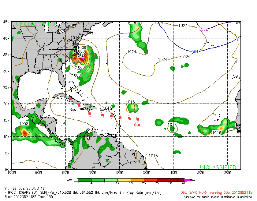
Just for kicks here is the 18z NOGAPS.
0 likes
Visit the Caribbean-Central America Weather Thread where you can find at first post web cams,radars
and observations from Caribbean basin members Click Here
and observations from Caribbean basin members Click Here
-
Hybridstorm_November2001

- S2K Supporter

- Posts: 2817
- Joined: Sat Aug 21, 2004 2:50 pm
- Location: SW New Brunswick, Canada
- Contact:
Re: ATL: ISAAC - Models
cycloneye wrote:Just for kicks here is the 18z NOGAPS.
Great New England Hurricane II
0 likes
-
Pigsnibble
- Tropical Low
- Posts: 42
- Joined: Sun Sep 12, 2004 6:38 am
Re: ATL: ISAAC - Models
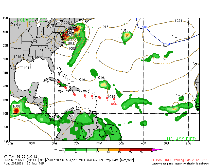
Like any recon data, next set will give us a better view. NOGAPS has its warts like everything else, but fun to watch....I like to watch CMC for potential development scenarios. It seems to see butterfly wing effects and develop them.
0 likes
-
Wx_Warrior
- Category 5
- Posts: 2718
- Joined: Thu Aug 03, 2006 3:58 pm
- Location: Beaumont, TX
Re: ATL: ISAAC - Models
That model is to the "good model" like William Chung was to American Idol. Funny, but not good.
0 likes
-
bamajammer4eva
- Category 4

- Posts: 907
- Joined: Sun Apr 18, 2010 3:21 am
- Location: Ozark, AL
Re: ATL: ISAAC - Models
weatherSnoop wrote:Jevo wrote:
3rd or 4th landfall... lets not forget about our friends in Haiti, Cuba, or South Florida
Not to mention, Tallahassee is inland
Oh yeah KTLH is 18 miles inland. Guess one could say Jacksonville and Panama City aren't actually on the coast either-only Panama City Beach and Jacksonville Beach.
0 likes
Re: ATL: ISAAC - Models
The model layout for Isaac looks strikingly similar to Irene last year at this point. Everyone was discussing Florida, and none of the models projected it moving over Puerto Rico like it did. In fact, most were clipping Hispaniola and going over east Cuba, if I recall correctly anyway?
0 likes
-
Hurricane Alexis

- Category 2

- Posts: 683
- Age: 29
- Joined: Thu Jun 14, 2012 7:59 pm
- Location: Miami,Florida
Re: ATL: ISAAC - Models
BobHarlem wrote:The model layout for Isaac looks strikingly similar to Irene last year at this point. Everyone was discussing Florida, and none of the models projected it moving over Puerto Rico like it did. In fact, most were clipping Hispaniola and going over east Cuba, if I recall correctly anyway?
But it's different this time because the models are in excellent agreement of Isaac going south of the islands and the ridge to the north is currently strong so Isaac should continue to move west.
0 likes
Personal Forecast Disclaimer:
The posts in this forum are NOT official forecast and should not be used as such. They are just the opinion of the poster and may or may not be backed by sound meteorological data. They are NOT endorsed by any professional institution or storm2k.org. For official information, please refer to the NHC and NWS products.
The posts in this forum are NOT official forecast and should not be used as such. They are just the opinion of the poster and may or may not be backed by sound meteorological data. They are NOT endorsed by any professional institution or storm2k.org. For official information, please refer to the NHC and NWS products.
-
WilmingtonSandbar
- S2K Supporter
- Posts: 505
- Joined: Sun Aug 29, 2010 12:11 pm
- Location: Southport, NC
Re: ATL: ISAAC - Models
I forgot the conversion. What time est is 0z? 0z is when the new models come out with the recon pass in it right?
0 likes
Diana X2 (look it up), Bertha, Fran, Bonnie, Floyd, Dennis, Charley, Ophelia, Ernesto, Irene, Matthew, And Florence
-
KBBOCA
- S2K Supporter
- Posts: 1559
- Joined: Fri Sep 05, 2003 5:27 am
- Location: Formerly Boca Raton, often West Africa. Currently Charlotte NC
Re: ATL: ISAAC - Models
WilmingtonSandbar wrote:I forgot the conversion. What time est is 0z? 0z is when the new models come out with the recon pass in it right?
0z is 8 p.m. Eastern during Daylight Savings Time
0 likes
-
tolakram
- Admin
- Posts: 20179
- Age: 62
- Joined: Sun Aug 27, 2006 8:23 pm
- Location: Florence, KY (name is Mark)
Re: ATL: ISAAC - Models
Right now EDT is -4 so 0z models are 8pm ... unfortunately I don't know when they first start generating output.
0 likes
M a r k
- - - - -
Join us in chat: Storm2K Chatroom Invite. Android and IOS apps also available.
The posts in this forum are NOT official forecasts and should not be used as such. Posts are NOT endorsed by any professional institution or STORM2K.org. For official information and forecasts, please refer to NHC and NWS products.
Re: ATL: ISAAC - Models
Hurricane Alexis wrote:BobHarlem wrote:The model layout for Isaac looks strikingly similar to Irene last year at this point. Everyone was discussing Florida, and none of the models projected it moving over Puerto Rico like it did. In fact, most were clipping Hispaniola and going over east Cuba, if I recall correctly anyway?
But it's different this time because the models are in excellent agreement of Isaac going south of the islands and the ridge to the north is currently strong so Isaac should continue to move west.
not all models are in agreement at this time gfs is more north into florida and the european model is to the south hitting the yucatan the american gfs is thinking a weaker bermuda high ridge and the european model is thinking a stronger ridge all other models are close for thee days out after that its up to how strong isaac gets or how weak he is everybody from the gulf to the east coast shoud monitor this carefully.
0 likes

Re: ATL: ISAAC - Models
0 likes
The following post is NOT an official forecast and should not be used as such. It is just the opinion of the poster and may or may not be backed by sound meteorological data. It is NOT endorsed by any professional institution including storm2k.org For Official Information please refer to the NHC and NWS products.
-
Evil Jeremy

- S2K Supporter
- Posts: 5463
- Age: 32
- Joined: Mon Apr 10, 2006 2:10 pm
- Location: Los Angeles, CA
Re: ATL: ISAAC - Models
tolakram wrote:Right now EDT is -4 so 0z models are 8pm ... unfortunately I don't know when they first start generating output.
1130 starts the output withGFS.
0 likes
Frances 04 / Jeanne 04 / Katrina 05 / Wilma 05 / Fay 08 / Debby 12 / Andrea 13 / Colin 16 / Hermine 16 / Matthew 16 / Irma 17
-
Hurricane Alexis
- Category 2
- Posts: 683
- Age: 29
- Joined: Thu Jun 14, 2012 7:59 pm
- Location: Miami,Florida
Re: ATL: ISAAC - Models
clipper35 wrote:Hurricane Alexis wrote:BobHarlem wrote:The model layout for Isaac looks strikingly similar to Irene last year at this point. Everyone was discussing Florida, and none of the models projected it moving over Puerto Rico like it did. In fact, most were clipping Hispaniola and going over east Cuba, if I recall correctly anyway?
But it's different this time because the models are in excellent agreement of Isaac going south of the islands and the ridge to the north is currently strong so Isaac should continue to move west.
not all models are in agreement at this time gfs is more north into florida and the european model is to the south hitting the yucatan the american gfs is thinking a weaker bermuda high ridge and the european model is thinking a stronger ridge all other models are close for thee days out after that its up to how strong isaac gets or how weak he is everybody from the gulf to the east coast shoud monitor this carefully.
I meant in that they're in agreement in not going north of Hispaniola and puerto rico, except a few models.
0 likes
Personal Forecast Disclaimer:
The posts in this forum are NOT official forecast and should not be used as such. They are just the opinion of the poster and may or may not be backed by sound meteorological data. They are NOT endorsed by any professional institution or storm2k.org. For official information, please refer to the NHC and NWS products.
The posts in this forum are NOT official forecast and should not be used as such. They are just the opinion of the poster and may or may not be backed by sound meteorological data. They are NOT endorsed by any professional institution or storm2k.org. For official information, please refer to the NHC and NWS products.
-
Evil Jeremy
- S2K Supporter
- Posts: 5463
- Age: 32
- Joined: Mon Apr 10, 2006 2:10 pm
- Location: Los Angeles, CA
Re: ATL: ISAAC - Models
I didnt see the new GFDL posted. Has a Broward County landfall in 5 days, much faster than the NHC forecast:
http://raleighwx.americanwx.com/models/ ... MSL120.gif
http://raleighwx.americanwx.com/models/ ... MSL120.gif
0 likes
Frances 04 / Jeanne 04 / Katrina 05 / Wilma 05 / Fay 08 / Debby 12 / Andrea 13 / Colin 16 / Hermine 16 / Matthew 16 / Irma 17
-
cycloneye
- Admin
- Posts: 149310
- Age: 69
- Joined: Thu Oct 10, 2002 10:54 am
- Location: San Juan, Puerto Rico
Re: ATL: ISAAC - Models
0 likes
Visit the Caribbean-Central America Weather Thread where you can find at first post web cams,radars
and observations from Caribbean basin members Click Here
and observations from Caribbean basin members Click Here
Re: ATL: ISAAC - Models
Evil Jeremy wrote:I didnt see the new GFDL posted. Has a Broward County landfall in 5 days, much faster than the NHC forecast:
i think the big qualifier on this run is the land interaction with Haiti/DR.. it goes right over mountains over 10,000ft high! lol
0 likes
-
weatherSnoop

- S2K Supporter
- Posts: 702
- Age: 63
- Joined: Wed Oct 09, 2002 10:06 pm
- Location: Tampa, FL
- Contact:
Re: ATL: ISAAC - Models
Oh yeah KTLH is 18 miles inland. Guess one could say Jacksonville and Panama City aren't actually on the coast either-only Panama City Beach and Jacksonville Beach.
But there is no Tallahassee Beach
0 likes
Who is online
Users browsing this forum: No registered users and 13 guests