

Next Mission...
TD-05 FLIGHT ONE -- TEAL 72--
A. 03/1800Z-04/0000Z
B. AFXXX 0305A CYCLONE
C. 03/1630Z
D. 14.0N 61.6W
E. 03/1730Z TO 04/2030Z
F. SFC TO 10,000 FT
ATL: ERNESTO - Post-Tropical
Moderator: S2k Moderators

Re: ATL: ERNESTO - Tropical Storm
I don't see him opening up into a wave today. the structure looks better, pressure slowing dropping, foreward speed could be a problem but not a huge one.
0 likes
The following post is NOT an official forecast and should not be used as such. It is just the opinion of the poster and may or may not be backed by sound meteorological data. It is NOT endorsed by any professional institution including storm2k.org For Official Information please refer to the NHC and NWS products.

Re: ATL: ERNESTO - Tropical Storm
HurrMark wrote:Definitely not as healthy this morning as last night. Frankly, in my opinion, it would not surprise me to see this degenerate to an open wave...24 mph in the Caribbean is a bit too fast. Euro might nail this one.
Usually tropical storms with this well defined of a center and recon reporting signs of a formative eyewall don't open up into waves very easily.
0 likes
-
cycloneye

- Admin

- Posts: 149317
- Age: 69
- Joined: Thu Oct 10, 2002 10:54 am
- Location: San Juan, Puerto Rico
Re: ATL: ERNESTO - Tropical Storm
RL3AO wrote:HurrMark wrote:Definitely not as healthy this morning as last night. Frankly, in my opinion, it would not surprise me to see this degenerate to an open wave...24 mph in the Caribbean is a bit too fast. Euro might nail this one.
Usually tropical storms with this well defined of a center and recon reporting signs of a formative eyewall don't open up into waves very easily.
Is expected to start to slowdown once arrives in Western Caribbean.
0 likes
Visit the Caribbean-Central America Weather Thread where you can find at first post web cams,radars
and observations from Caribbean basin members Click Here
and observations from Caribbean basin members Click Here
-
Rgv20

- S2K Supporter

- Posts: 2466
- Age: 39
- Joined: Wed Jan 05, 2011 5:42 pm
- Location: Edinburg/McAllen Tx
6zGFS still forecast Ernesto to be in the Western GOM by late next week/weekend..

0 likes
The following post is NOT an official forecast and should not be used as such. It is just the opinion of the poster and may or may not be backed by sound meteorological data. It is NOT endorsed by any professional institution including storm2k.org For Official Information please refer to the NHC and NWS products.
Re: ATL: ERNESTO - Tropical Storm
Much disagreement exists between the much more conservative way of classifying Tropical Depressions, Storms and Hurricanes years ago and what's out there this morning - 30 years ago a disturbance like this would be mentioned in the TWO as one - but not upgraded to a TS or even TD, that's for sure...
What is classified as TS Ernesto looks hardly like a tropical low at all - as others said perhaps it will be downgraded to a TD or wave today...
What is classified as TS Ernesto looks hardly like a tropical low at all - as others said perhaps it will be downgraded to a TD or wave today...
0 likes
-
Rgv20
- S2K Supporter
- Posts: 2466
- Age: 39
- Joined: Wed Jan 05, 2011 5:42 pm
- Location: Edinburg/McAllen Tx
Corpus NWS Morning Discussion..
"UNCERTAINTY DEFINITELY INCREASES AFTER THURSDAY AS
ALL WILL DEPEND ON ERNESTO...WHERE IT IS AND HOW STRONG IT IS...AS
WELL AS THE UPPER PATTERN WHICH WILL DICTATE WHERE ERNESTO WILL GO
(IF IT GOES TOO FAR SOUTH AND INTO MOUNTAINS AS SOMETHING WEAKER MAY
NOT BE MUCH OF AN ERNESTO...THAT IS WHAT ECMWF IS SAYING).
HOWEVER...THAT IS BEYOND THIS FORECAST PERIOD BUT POTENTIAL
CHALLENGING FORECAST ON THE HORIZON."
0 likes
The following post is NOT an official forecast and should not be used as such. It is just the opinion of the poster and may or may not be backed by sound meteorological data. It is NOT endorsed by any professional institution including storm2k.org For Official Information please refer to the NHC and NWS products.
-
tolakram
- Admin
- Posts: 20179
- Age: 62
- Joined: Sun Aug 27, 2006 8:23 pm
- Location: Florence, KY (name is Mark)
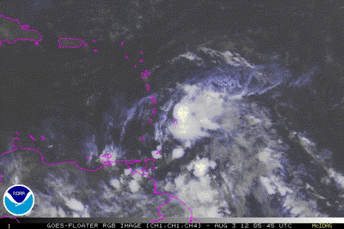
Re: ATL: ERNESTO - Tropical Storm
Latest

0 likes
M a r k
- - - - -
Join us in chat: Storm2K Chatroom Invite. Android and IOS apps also available.
The posts in this forum are NOT official forecasts and should not be used as such. Posts are NOT endorsed by any professional institution or STORM2K.org. For official information and forecasts, please refer to NHC and NWS products.
-
tolakram
- Admin
- Posts: 20179
- Age: 62
- Joined: Sun Aug 27, 2006 8:23 pm
- Location: Florence, KY (name is Mark)
Re: ATL: ERNESTO - Tropical Storm
Loop
0 likes
M a r k
- - - - -
Join us in chat: Storm2K Chatroom Invite. Android and IOS apps also available.
The posts in this forum are NOT official forecasts and should not be used as such. Posts are NOT endorsed by any professional institution or STORM2K.org. For official information and forecasts, please refer to NHC and NWS products.
- - - - -
Join us in chat: Storm2K Chatroom Invite. Android and IOS apps also available.
The posts in this forum are NOT official forecasts and should not be used as such. Posts are NOT endorsed by any professional institution or STORM2K.org. For official information and forecasts, please refer to NHC and NWS products.
-
hurricanes1234
- Category 5

- Posts: 2908
- Joined: Sat Jul 28, 2012 6:19 pm
- Location: Trinidad and Tobago
Re: ATL: ERNESTO - Tropical Storm
I agree wih FireBird, I live in Trinidad, also, and in my area, the thunder rocked my house for about an hour, along with the rainfall.
0 likes
PLEASE NOTE: With the exception of information from weather agencies that I may copy and paste here, my posts will NEVER be official, since I am NOT a meteorologist. They are solely my amateur opinion, and may or may not be accurate. Therefore, please DO NOT use them as official details, particularly when making important decisions. Thank you.
-
Dean4Storms
- S2K Supporter
- Posts: 6358
- Age: 63
- Joined: Sun Aug 31, 2003 1:01 pm
- Location: Miramar Bch. FL
06z GFDL holds firm with a turn toward the northern Gulf Coast with Ernesto an intensifying Hurricane.
http://moe.met.fsu.edu/cgi-bin/gfdltc2. ... =Animation
http://moe.met.fsu.edu/cgi-bin/gfdltc2. ... =Animation
0 likes
-
Meso

- Category 5
- Posts: 1609
- Age: 39
- Joined: Mon Aug 09, 2004 12:14 pm
- Location: South Africa
- Contact:
Re: ATL: ERNESTO - Models
12z SHIPS
Code: Select all
                    *   ATLANTIC SHIPS INTENSITY FORECAST       *
                    * GOES AVAILABLE,       OHC AVAILABLE       *
                    *     ERNESTO  AL052012  08/03/12  12 UTC   *

TIME (HR)          0     6    12    18    24    36    48    60    72    84    96   108   120
V (KT) NO LAND    45    45    46    48    50    53    57    66    73    79    84    87    86
V (KT) LAND       45    45    46    48    50    53    57    66    73    79    84    87    86
V (KT) LGE mod    45    45    46    48    50    56    62    70    80    91   100   105   103
Storm Type      TROP  TROP  TROP  TROP  TROP  TROP  TROP  TROP  TROP  TROP  TROP  TROP  TROP

SHEAR (KT)        14     7     5     4     7     6    11     2     6     2     5     8     9
SHEAR ADJ (KT)     0    -2    -3     1     0     0    -5    -1    -3     0     3    -1     2
SHEAR DIR        283   290   214   265   280   243   302    77   319   111   275   222   267
SST (C)         28.0  27.9  28.1  28.4  28.5  28.0  28.3  28.5  28.4  28.6  28.8  29.0  28.5
POT. INT. (KT)   140   138   140   144   146   139   143   145   143   145   148   152   144
ADJ. POT. INT.   144   140   142   145   147   139   142   142   137   137   139   143   133
200 MB T (C)   -53.7 -53.2 -53.1 -53.3 -53.3 -52.4 -52.9 -52.5 -52.8 -52.2 -52.7 -52.2 -52.7
TH_E DEV (C)       9    10    10     9     9    10     8     9     8     9     7     9     8
700-500 MB RH     57    57    59    61    61    62    65    67    69    74    72    74    73
GFS VTEX (KT)     11    12    11    12    11     9     9     9     9     8     9     9     9
850 MB ENV VOR    32    36    40    51    53    73    79    77    68    64    37    48    18
200 MB DIV       -18    -3    30    35    51    47    20    71    43    40    33    38    28
700-850 TADV      -4    -3    -2    -7    -2    -1    -1    -6    -7    -4    -8    -5   -10
LAND (KM)        315   338   368   392   336   277   257   147   177   330   346   233    23
LAT (DEG N)     13.6  13.8  13.9  14.2  14.4  14.9  15.7  16.4  17.0  17.8  18.7  19.7  20.8
LONG(DEG W)     61.5  63.2  64.9  66.4  67.9  71.0  74.1  76.9  79.4  81.4  83.0  84.8  86.7
STM SPEED (KT)    18    17    16    15    15    15    15    13    11    10     9    10    10
HEAT CONTENT      53    43    33    52    68    72    52    91   114    92    96   124    45
0 likes
-
Stormlover2012
- Category 1

- Posts: 262
- Joined: Sat Jun 23, 2012 11:03 am
Re: ATL: ERNESTO - Models
stronger the storm is it will feel the weakness and weaker the storm like euro and gfs shows then it will keep chugging west
0 likes
-
Stormcenter
- S2K Supporter
- Posts: 6689
- Joined: Wed Sep 03, 2003 11:27 am
- Location: Houston, TX
Re: ATL: ERNESTO - Tropical Storm
Good post and I agree 100%.
Frank2 wrote:Much disagreement exists between the much more conservative way of classifying Tropical Depressions, Storms and Hurricanes years ago and what's out there this morning - 30 years ago a disturbance like this would be mentioned in the TWO as one - but not upgraded to a TS or even TD, that's for sure...
What is classified as TS Ernesto looks hardly like a tropical low at all - as others said perhaps it will be downgraded to a TD or wave today...
0 likes
-
tolakram
- Admin
- Posts: 20179
- Age: 62
- Joined: Sun Aug 27, 2006 8:23 pm
- Location: Florence, KY (name is Mark)
Re: ATL: ERNESTO - Models
That shear forecast looks very wrong. Yes, they are usually wrong, but I really don't see how it can predict such low shear in just hours from now.

0 likes
M a r k
- - - - -
Join us in chat: Storm2K Chatroom Invite. Android and IOS apps also available.
The posts in this forum are NOT official forecasts and should not be used as such. Posts are NOT endorsed by any professional institution or STORM2K.org. For official information and forecasts, please refer to NHC and NWS products.
- - - - -
Join us in chat: Storm2K Chatroom Invite. Android and IOS apps also available.
The posts in this forum are NOT official forecasts and should not be used as such. Posts are NOT endorsed by any professional institution or STORM2K.org. For official information and forecasts, please refer to NHC and NWS products.
-
tolakram
- Admin
- Posts: 20179
- Age: 62
- Joined: Sun Aug 27, 2006 8:23 pm
- Location: Florence, KY (name is Mark)
Re: ATL: ERNESTO - Models
Especially considering the rapid forward motion and the fact the shear is coming from the west.

0 likes
M a r k
- - - - -
Join us in chat: Storm2K Chatroom Invite. Android and IOS apps also available.
The posts in this forum are NOT official forecasts and should not be used as such. Posts are NOT endorsed by any professional institution or STORM2K.org. For official information and forecasts, please refer to NHC and NWS products.
- - - - -
Join us in chat: Storm2K Chatroom Invite. Android and IOS apps also available.
The posts in this forum are NOT official forecasts and should not be used as such. Posts are NOT endorsed by any professional institution or STORM2K.org. For official information and forecasts, please refer to NHC and NWS products.
-
TropicalAnalystwx13

- Category 5
- Posts: 2109
- Age: 28
- Joined: Tue Jul 19, 2011 8:20 pm
- Location: Wilmington, NC
- Contact:
Ernesto may not be the most well-defined tropical storm ever, but it's organized enough to be considered a tropical cyclone. It has a very well-defined, strong, and closed center of circulation. Convection has continually been bursting on top of it (its in the process right now) and sustaining itself for most of the day. Winds are 50 mph (back up according to best track). The chances of dissipation over the next 2-3 days are below 10%.

0 likes
Re: ATL: ERNESTO - Tropical Storm
I think it's saving its thunder for further west. The first ice-breaking system usually struggles like this. Actually this is showing sings of better organization if you look at the shape.
0 likes
-
Nederlander
- S2K Supporter
- Posts: 1259
- Joined: Sat Jul 19, 2008 4:28 pm
- Location: Conroe, TX
Re: ATL: ERNESTO - Tropical Storm
Not sure why some people are thinking this will be downgraded. Looking pretty good given the circumstances. Not only did it withstand moderate shear the last couple of day, but it strengthened to mid-range TS. Don't let it's ragged look fool you. It's got a well defined coc and nice convection to boot.. It should look a little better by this evening.
Personal Forecast Disclaimer: The posts in this forum are NOT official forecast and should not be used as such. They are just the opinion of the poster and may or may not be backed by sound meteorological data. They are NOT endorsed by any professional institution or storm2k.org. For official information, please refer to the NHC and NWS products.
Personal Forecast Disclaimer: The posts in this forum are NOT official forecast and should not be used as such. They are just the opinion of the poster and may or may not be backed by sound meteorological data. They are NOT endorsed by any professional institution or storm2k.org. For official information, please refer to the NHC and NWS products.
0 likes
-
tolakram
- Admin
- Posts: 20179
- Age: 62
- Joined: Sun Aug 27, 2006 8:23 pm
- Location: Florence, KY (name is Mark)
Re: ATL: ERNESTO - Tropical Storm
Where is that well defined center of circulation?
live loop: http://wwwghcc.msfc.nasa.gov/cgi-bin/ge ... umframes=5
Bands on the west side of the storm are moving south and convection over what may have been the center is dying out while a new pulse is occurring further north. This looks more like a wave trying to close off a circulation than a storm with a clear circulation.
Personal Forecast Disclaimer:
The posts in this forum are NOT official forecast and should not be used as such. They are just the opinion of the poster and may or may not be backed by sound meteorological data. They are NOT endorsed by any professional institution or storm2k.org. For official information, please refer to the NHC and NWS products.
0 likes
M a r k
- - - - -
Join us in chat: Storm2K Chatroom Invite. Android and IOS apps also available.
The posts in this forum are NOT official forecasts and should not be used as such. Posts are NOT endorsed by any professional institution or STORM2K.org. For official information and forecasts, please refer to NHC and NWS products.
- - - - -
Join us in chat: Storm2K Chatroom Invite. Android and IOS apps also available.
The posts in this forum are NOT official forecasts and should not be used as such. Posts are NOT endorsed by any professional institution or STORM2K.org. For official information and forecasts, please refer to NHC and NWS products.
Who is online
Users browsing this forum: No registered users and 93 guests