ATL: BERYL - Post-Tropical
Moderator: S2k Moderators
-
Aric Dunn
- Category 5

- Posts: 21238
- Age: 43
- Joined: Sun Sep 19, 2004 9:58 pm
- Location: Ready for the Chase.
- Contact:
the sfwmd site has storm 02 now ?
http://www.sfwmd.gov/portal/page/portal ... el%20plots
http://www.sfwmd.gov/portal/page/portal ... el%20plots
0 likes
Note: If I make a post that is brief. Please refer back to previous posts for the analysis or reasoning. I do not re-write/qoute what my initial post said each time.
If there is nothing before... then just ask
Space & Atmospheric Physicist, Embry-Riddle Aeronautical University,
I believe the sky is falling...
If there is nothing before... then just ask
Space & Atmospheric Physicist, Embry-Riddle Aeronautical University,
I believe the sky is falling...
-
Brent
- S2K Supporter

- Posts: 38729
- Age: 37
- Joined: Sun May 16, 2004 10:30 pm
- Location: Tulsa Oklahoma
- Contact:
Re:
Aric Dunn wrote:the sfwmd site has storm 02 now ?
http://www.sfwmd.gov/portal/page/portal ... el%20plots
I believe that's Bud
0 likes
#neversummer
-
Aric Dunn
- Category 5

- Posts: 21238
- Age: 43
- Joined: Sun Sep 19, 2004 9:58 pm
- Location: Ready for the Chase.
- Contact:
Re: Re:
Brent wrote:Aric Dunn wrote:the sfwmd site has storm 02 now ?
http://www.sfwmd.gov/portal/page/portal ... el%20plots
I believe that's Bud
they never do anything with the pacific.
0 likes
Note: If I make a post that is brief. Please refer back to previous posts for the analysis or reasoning. I do not re-write/qoute what my initial post said each time.
If there is nothing before... then just ask
Space & Atmospheric Physicist, Embry-Riddle Aeronautical University,
I believe the sky is falling...
If there is nothing before... then just ask
Space & Atmospheric Physicist, Embry-Riddle Aeronautical University,
I believe the sky is falling...
- 'CaneFreak
- Category 5

- Posts: 1487
- Joined: Mon Jun 05, 2006 10:50 am
- Location: New Bern, NC
Re: Re:
Yeah they do. That is Bud. There are only two model plots that show up for Bud right now in both the legend and on the map. For 94L, the fresh 18Z BAMs were run on it. So, it is still 94L.
Aric Dunn wrote:Brent wrote:Aric Dunn wrote:the sfwmd site has storm 02 now ?
http://www.sfwmd.gov/portal/page/portal ... el%20plots
I believe that's Bud
they never do anything with the pacific.
0 likes
-
Aric Dunn
- Category 5

- Posts: 21238
- Age: 43
- Joined: Sun Sep 19, 2004 9:58 pm
- Location: Ready for the Chase.
- Contact:
okie dokie.
0 likes
Note: If I make a post that is brief. Please refer back to previous posts for the analysis or reasoning. I do not re-write/qoute what my initial post said each time.
If there is nothing before... then just ask
Space & Atmospheric Physicist, Embry-Riddle Aeronautical University,
I believe the sky is falling...
If there is nothing before... then just ask
Space & Atmospheric Physicist, Embry-Riddle Aeronautical University,
I believe the sky is falling...
-
jlauderdal
- S2K Supporter

- Posts: 7240
- Joined: Wed May 19, 2004 5:46 am
- Location: NE Fort Lauderdale
- Contact:
Re: ATL: INVEST 94L
Sun is out in full force NE FLL, winds maybe 7 mph, maybe the heating will get the tstorms going. Very interesting day here to say the least, urban flood advisory, then wind and now calm and stable.
0 likes
-
tolakram
- Admin

- Posts: 20179
- Age: 62
- Joined: Sun Aug 27, 2006 8:23 pm
- Location: Florence, KY (name is Mark)
Re: ATL: INVEST 94L
0 likes
M a r k
- - - - -
Join us in chat: Storm2K Chatroom Invite. Android and IOS apps also available.
The posts in this forum are NOT official forecasts and should not be used as such. Posts are NOT endorsed by any professional institution or STORM2K.org. For official information and forecasts, please refer to NHC and NWS products.
- HurricaneBelle
- S2K Supporter

- Posts: 1209
- Joined: Sun Aug 27, 2006 6:12 pm
- Location: Clearwater, FL
Re:
northjaxpro wrote:NWS Tampa mets sticking by the GFS runs on their long range discussion just issued this afternoon regarding the evolution of 94L:
FYI, starting several months ago NWS Tampa now only issues one long-term discussion a day, with the overnight (2-4 AM) AFD; the one in the afternoon is just a rerun as they only update the short-term at that time.
0 likes
- northjaxpro
- S2K Supporter

- Posts: 8900
- Joined: Mon Sep 27, 2010 11:21 am
- Location: Jacksonville, FL
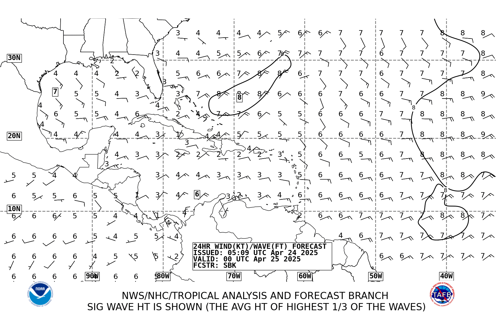
TAFB is forecasting 94L/potential Beryl positioned about 150-200 iles off shore Cape Canveral tomorrow morning at 12Z


0 likes
NEVER, EVER SAY NEVER in the tropics and weather in general, and most importantly, with life itself!!
________________________________________________________________________________________
Fay 2008 Beryl 2012 Debby 2012 Colin 2016 Hermine 2016 Julia 2016 Matthew 2016 Irma 2017 Dorian 2019
________________________________________________________________________________________
Fay 2008 Beryl 2012 Debby 2012 Colin 2016 Hermine 2016 Julia 2016 Matthew 2016 Irma 2017 Dorian 2019
- northjaxpro
- S2K Supporter

- Posts: 8900
- Joined: Mon Sep 27, 2010 11:21 am
- Location: Jacksonville, FL
Re: Re:
HurricaneBelle wrote:northjaxpro wrote:NWS Tampa mets sticking by the GFS runs on their long range discussion just issued this afternoon regarding the evolution of 94L:
FYI, starting several months ago NWS Tampa now only issues one long-term discussion a day, with the overnight (2-4 AM) AFD; the one in the afternoon is just a rerun as they only update the short-term at that time.
Thanks for that info. I wasn't aware they did that with their long-range discussions. They do it different than the NWS Jax office or most of the other WFOs in the state for that matter as far as I am aware.
0 likes
NEVER, EVER SAY NEVER in the tropics and weather in general, and most importantly, with life itself!!
________________________________________________________________________________________
Fay 2008 Beryl 2012 Debby 2012 Colin 2016 Hermine 2016 Julia 2016 Matthew 2016 Irma 2017 Dorian 2019
________________________________________________________________________________________
Fay 2008 Beryl 2012 Debby 2012 Colin 2016 Hermine 2016 Julia 2016 Matthew 2016 Irma 2017 Dorian 2019
-
ozonepete
- Professional-Met

- Posts: 4743
- Joined: Mon Sep 07, 2009 3:23 pm
- Location: From Ozone Park, NYC / Now in Brooklyn, NY
Re: ATL: INVEST 94L
tolakram wrote:Visible, zoomed out a bit.
http://img201.imageshack.us/img201/7875/ztemp.jpg
Live Loop: http://wwwghcc.msfc.nasa.gov/cgi-bin/ge ... mframes=15
Maybe a developing subtropical storm has had that look...
0 likes
- Hurricane Andrew
- S2K Supporter

- Posts: 1891
- Age: 27
- Joined: Sun May 23, 2010 2:53 pm
- Location: KS
-
CrazyC83
- Professional-Met

- Posts: 34315
- Joined: Tue Mar 07, 2006 11:57 pm
- Location: Deep South, for the first time!
Re: Re:
Hurricanehink wrote:CrazyC83 wrote:Time to lengthen hurricane season perhaps?
We've had Andrea and Barry in 2007 (Barry was a low on May 31st that became a tropical cyclone on June 1st), Arthur in 2008, TD 1 in 2009 (plus the Gulf low that nearly became a tropical cyclone in May '09), and then this year we had the invest near the Azores that could be added afterward, Alberto, and 94L. That's five systems in the past ten years. For comparison, in the ten years prior to 1964 (when the season was pushed back from June 15th to June 1st), there was a tropical storm in 1956, 1957, 1958 (Alma), and 1959 (although Arlene formed in late May but lasted until early June) in the period from June 1st to June 14th. It'd come down to whether the cost justifies extending the Atlantic season back to May 15th (I can't see them going back any earlier), and since the EPAC already starts on the 15th, I don't think it'd be that much more (if any) to have the Atlantic season start at the same time. If 94L becomes Beryl, and that Azores invest gets added (unlikely that both happens, but you never know), then I think there may be calls to extend the season back.
Yeah maybe, and we've had a few December storms the last decade too. May 15 to December 15 seems the most plausible extension.
0 likes
- cycloneye
- Admin

- Posts: 149275
- Age: 69
- Joined: Thu Oct 10, 2002 10:54 am
- Location: San Juan, Puerto Rico
Re: ATL: INVEST 94L
There has been references to 1887 as the last year there were two named storms prior to June 1rst,but I found another year ahead (1908) when two hurricanes formed,one in March and the other on late May.
http://weather.unisys.com/hurricane/atl ... /index.php
http://weather.unisys.com/hurricane/atl ... /index.php
0 likes
Visit the Caribbean-Central America Weather Thread where you can find at first post web cams,radars
and observations from Caribbean basin members Click Here
and observations from Caribbean basin members Click Here
-
Aric Dunn
- Category 5

- Posts: 21238
- Age: 43
- Joined: Sun Sep 19, 2004 9:58 pm
- Location: Ready for the Chase.
- Contact:
well it appears the circ near the keys is becoming elongated and weakening. so I would bet yet another circ is going to get started shortly somewhere to the NE and this same process will happen again just slightly farther up the coast. This is all due to the strong shear of course. everytime we get a burst of convection bet on a new vort to spin up.
0 likes
Note: If I make a post that is brief. Please refer back to previous posts for the analysis or reasoning. I do not re-write/qoute what my initial post said each time.
If there is nothing before... then just ask
Space & Atmospheric Physicist, Embry-Riddle Aeronautical University,
I believe the sky is falling...
If there is nothing before... then just ask
Space & Atmospheric Physicist, Embry-Riddle Aeronautical University,
I believe the sky is falling...
- wxman57
- Moderator-Pro Met

- Posts: 23172
- Age: 68
- Joined: Sat Jun 21, 2003 8:06 pm
- Location: Houston, TX (southwest)
Re: ATL: INVEST 94L
I'd say about a 90-100% chance of Beryl by Sunday. Should be subtropical to start with. Great deal of shear until late Saturday. Maybe a strong TS Sunday as it heads SW toward NE Florida. Some weakening likely before it reaches the coast. Third TS of the season (Azores system will likely be classified as such after the season ends.)
0 likes
- Hurricane Andrew
- S2K Supporter

- Posts: 1891
- Age: 27
- Joined: Sun May 23, 2010 2:53 pm
- Location: KS
- cycloneye
- Admin

- Posts: 149275
- Age: 69
- Joined: Thu Oct 10, 2002 10:54 am
- Location: San Juan, Puerto Rico
Re: ATL: INVEST 94L
wxman57 wrote:I'd say about a 90-100% chance of Beryl by Sunday. Should be subtropical to start with. Great deal of shear until late Saturday. Maybe a strong TS Sunday as it heads SW toward NE Florida. Some weakening likely before it reaches the coast. Third TS of the season (Azores system will likely be classified as such after the season ends.
Seeing you bullish means it will happen.
0 likes
Visit the Caribbean-Central America Weather Thread where you can find at first post web cams,radars
and observations from Caribbean basin members Click Here
and observations from Caribbean basin members Click Here
Who is online
Users browsing this forum: No registered users and 67 guests


